Aquí encontrarás todo lo relacionado al la meteorología en Puerto Rico y las condiciones del tiempo actuales, así como los huracanes que se desarrollen durante las temporadas ciclónicas, actualizados por expertos y aficionados a la meteorología de todo el pais! Este es tu foro! Leelo, escribe en el y disfrútalo! Cycloman.
StormWatch wrote: ↑Wed Jun 30, 2021 1:41 am
5am: DT
11am: Tormenta Tropical Elsa
Leer mi disclaimer..!!
No me sorprenderia... Danny fue de 60% a tormenta Danny... este ya tiene 70%
y la organización que ha estado adquiriendo pues esta a tiro de hit para que la clasifiquen
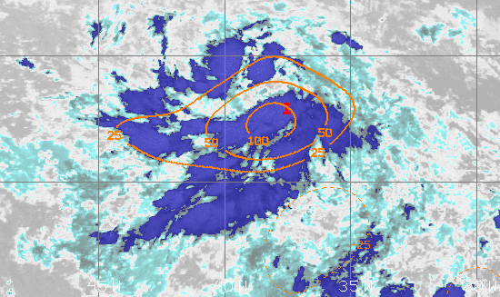
A broad area of low pressure, associated with a tropical wave, is located about midway between the west coast of Africa and the Windward Islands. This system is producing a large area of showers and thunderstorms that continues to show some signs of organization.
Environmental conditions appear generally favorable for development, and a tropical depression is likely form during the next few days while the system moves west-northwestward at about 20 mph.
Interests in the Windward and Leeward Islands should closely monitor this system as it will likely be moving through that region on Friday.
* Formation chance through 48 hours...50 percent.
* Formation chance through 5 days...70 percent.
Last edited by StormWatch on Wed Jun 30, 2021 1:49 am, edited 2 times in total.
Hurricane’s hit Puerto Rico: San Felipe 1928, San Ciprián 1932, Santa Clara 1956, Hugo 1989, Marilyn 1995, Hortense 1996, Georges 1998, Maria 2017, Fiona 2022
Hurricane’s hit Puerto Rico: San Felipe 1928, San Ciprián 1932, Santa Clara 1956, Hugo 1989, Marilyn 1995, Hortense 1996, Georges 1998, Maria 2017, Fiona 2022
Hurricane’s hit Puerto Rico: San Felipe 1928, San Ciprián 1932, Santa Clara 1956, Hugo 1989, Marilyn 1995, Hortense 1996, Georges 1998, Maria 2017, Fiona 2022
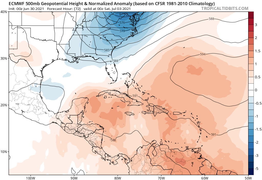
En este reporte, ya la proyección empieza a subirlo más al norte. Estamos a ley de una vaguada en el Este de E.U para que recibamos el impacto directo, muy probablemente como un huracán. En Julio!!! Increíble!!!
Georges_98 wrote: ↑Wed Jun 30, 2021 2:15 am
En este reporte, ya la proyección empieza a subirlo más al norte. Estamos a ley de una vaguada en el Este de E.U para que recibamos el impacto directo, muy probablemente como un huracán. En Julio!!! Increíble!!!
Si parece que esa vaguada sera bastante fuerte... incluso el EURO y el GFS estan de acuerdo en mostrar esa vaguada... cosa que muchas veces no estan tan de acuerdo
GFS
EURO
Tropical Weather Outlook
NWS National Hurricane Center Miami FL
800 AM EDT Wed Jun 30 2021
For the North Atlantic...Caribbean Sea and the Gulf of Mexico:
A broad area of low pressure, associated with a tropical wave, is located about midway between the west coast of Africa and the Windward Islands. This system is producing a large area of showers and thunderstorms that continues to show some signs of organization.
Environmental conditions appear generally favorable for development, and a tropical depression is likely to form during the next few days while the system moves west-northwestward at about 20 mph. Interests in the Windward and Leeward Islands should closely monitor this system as it will likely be moving through that region on Friday.
* Formation chance through 48 hours...60 percent.
* Formation chance through 5 days...80 percent.
Hurricane’s hit Puerto Rico: San Felipe 1928, San Ciprián 1932, Santa Clara 1956, Hugo 1989, Marilyn 1995, Hortense 1996, Georges 1998, Maria 2017, Fiona 2022