
Huracán Irma
Re: Huracán Irma - Categoría 4
No sé porque me siento como si me fuera a sentar en la silla eléctrica, contando el tiempo que nos queda. Dios quiera y me equivoque bien duro.
Las vaguadas no somos tan malas como algunos creen 
Re: Huracán Irma - Categoría 4
Si esto se confirma, pues mis ojos no están tan asustaos na

Las vaguadas no somos tan malas como algunos creen

Re: Huracán Irma - Categoría 4
Se mueve oeste o ya dio el giro por qué estoy en la clínica y no puedo ver el satélite en movimiento
-
StormWatch
- Cat. 3

- Posts: 3755
- Joined: Thu Aug 06, 2015 11:39 am
- Location: Texas, USA
Re: Huracán Irma - Categoría 4
Ese ojo debe medir muchísimo cuando lo estimen!
Creo q con esta gráfica oficial del NHC, da escalofríos
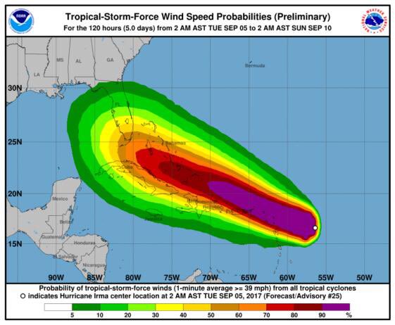
Creo q con esta gráfica oficial del NHC, da escalofríos
Member Since 2005
For official information, please refer to NHC: https://www.nhc.noaa.gov
Hurricane’s hit Puerto Rico:
San Felipe 1928, San Ciprián 1932, Santa Clara 1956, Hugo 1989, Marilyn 1995, Hortense 1996, Georges 1998, Maria 2017, Fiona 2022
Model Runs:
GFS:
[5:30 AM/PM, 11:30 AM/PM]
HWRF, GFDL, UKMET, NAVGEM:
[6:30-8:00 AM/PM, 12:30-2:00 AM/PM]
ECMWF:
[1:45 AM/PM]

Re: Huracán Irma - Categoría 4
Y bien que sí. PAr de horas mas al oeste de lo pronosticado, un wobble en nuestra area, cualquier cambio pequeño al oeste nos pone a IRMA de sombrero.StormWatch wrote: ↑Tue Sep 05, 2017 9:20 am Ese ojo debe medir muchísimo cuando lo estimen!
Creo q con esta gráfica oficial del NHC, da escalofríos
This sh_t got real!!!
-
StormWatch
- Cat. 3
- Posts: 3755
- Joined: Thu Aug 06, 2015 11:39 am
- Location: Texas, USA
Re: Huracán Irma - Categoría 4
Sin palabras! Seguimos mi gente....

Member Since 2005
For official information, please refer to NHC: https://www.nhc.noaa.gov
Hurricane’s hit Puerto Rico:
San Felipe 1928, San Ciprián 1932, Santa Clara 1956, Hugo 1989, Marilyn 1995, Hortense 1996, Georges 1998, Maria 2017, Fiona 2022
Model Runs:
GFS:
[5:30 AM/PM, 11:30 AM/PM]
HWRF, GFDL, UKMET, NAVGEM:
[6:30-8:00 AM/PM, 12:30-2:00 AM/PM]
ECMWF:
[1:45 AM/PM]
For official information, please refer to NHC: https://www.nhc.noaa.gov
Hurricane’s hit Puerto Rico:
San Felipe 1928, San Ciprián 1932, Santa Clara 1956, Hugo 1989, Marilyn 1995, Hortense 1996, Georges 1998, Maria 2017, Fiona 2022
Model Runs:
GFS:
[5:30 AM/PM, 11:30 AM/PM]
HWRF, GFDL, UKMET, NAVGEM:
[6:30-8:00 AM/PM, 12:30-2:00 AM/PM]
ECMWF:
[1:45 AM/PM]

Re: Huracán Irma - Categoría 4
Product: Air Force Temp Drop (Dropsonde) Message (UZNT13 KNHC)
Transmitted: 5th day of the month at 11:48Z
Agency: United States Air Force
Aircraft: Lockheed WC-130J Hercules with reg. number AF99-5309
Storm Number: 11
Storm Name: Irma (flight in the North Atlantic basin)
Mission Number: 8
Observation Number: 07
Part A...
Date: Near the closest hour of 11Z on the 5th day of the month
Highest Mandatory Level For Which Wind Was Reported: 700mb
Coordinates: 16.9N 57.5W
Location: 280 statute miles (451 km) to the ENE (67°) from Roseau, Dominica.
Marsden Square: 042
Surface and Standard Isobaric Surfaces
Level Geo. Height Air Temp. Dew Point Wind Direction Wind Speed
1000mb This level does not exist in this area of the storm above the surface level.
947mb (27.97 inHg) Surface (Sea Level) 25.0°C (77.0°F) 24.8°C (77°F) 65° (from the ENE) 129 knots (148 mph)
925mb 208m (682 ft) 23.0°C (73.4°F) 22.7°C (73°F) 70° (from the ENE) 158 knots (182 mph)
850mb 945m (3,100 ft) 20.0°C (68.0°F) 19.4°C (67°F) 115° (from the ESE) 170 knots (196 mph)
700mb 2,612m (8,570 ft) 12.8°C (55.0°F) 12.8°C (55°F) 130° (from the SE) 129 knots (148 mph)
Information About Radiosonde:
- Launch Time: 11:24Z
- About Sonde: A descending radiosonde tracked automatically by satellite navigation with no solar or infrared correction.
Remarks Section...
Dropsonde Location: Dropped in eyewall 45° (NE) from the eye center.
Highest altitude where wind was reported:
- Location: 16.90N 57.52W
- Time: 11:24:33Z
Lowest altitude where wind was reported:
- Location: 16.95N 57.71W
- Time: 11:29:18Z
Mean Boundary Level Wind (mean wind in the lowest 500 geopotential meters of the sounding):
- Wind Direction: 75° (from the ENE)
- Wind Speed: 168 knots (193 mph)
Deep Layer Mean Wind (average wind over the depth of the sounding):
- Wind Direction: 110° (from the ESE)
- Wind Speed: 144 knots (166 mph)
- Depth of Sounding: From 696mb to 946mb
Average Wind Over Lowest Available 150 geopotential meters (gpm) of the sounding:
- Lowest 150m: 156 gpm - 6 gpm (512 geo. feet - 20 geo. feet)
- Wind Direction: 70° (from the ENE)
- Wind Speed: 157 knots (181 mph)
Sounding Software Version: AEV 33304
Part B: Data for Significant Levels...
Significant Temperature And Relative Humidity Levels
Level Air Temperature Dew Point
947mb (Surface) 25.0°C (77.0°F) 24.8°C (77°F)
850mb 20.0°C (68.0°F) 19.4°C (67°F)
707mb 15.0°C (59.0°F) 14.6°C (58°F)
696mb 11.6°C (52.9°F) 11.6°C (53°F)
Significant Wind Levels
Level Wind Direction Wind Speed
947mb (Surface) 65° (from the ENE) 129 knots (148 mph)
946mb 65° (from the ENE) 128 knots (147 mph)
944mb 60° (from the ENE) 150 knots (173 mph)
943mb 65° (from the ENE) 157 knots (181 mph)
929mb 70° (from the ENE) 165 knots (190 mph)
922mb 70° (from the ENE) 156 knots (180 mph)
918mb 70° (from the ENE) 172 knots (198 mph)
914mb 80° (from the E) 178 knots (205 mph)
913mb 80° (from the E) 180 knots (207 mph)
902mb 85° (from the E) 188 knots (216 mph)
899mb 85° (from the E) 186 knots (214 mph)
894mb 90° (from the E) 173 knots (199 mph)
886mb 95° (from the E) 174 knots (200 mph)
881mb 100° (from the E) 182 knots (209 mph)
878mb 100° (from the E) 181 knots (208 mph)
873mb 100° (from the E) 171 knots (197 mph)
864mb 105° (from the ESE) 145 knots (167 mph)
863mb 105° (from the ESE) 147 knots (169 mph)
860mb 110° (from the ESE) 162 knots (186 mph)
858mb 110° (from the ESE) 166 knots (191 mph)
850mb 115° (from the ESE) 170 knots (196 mph)
828mb 115° (from the ESE) 177 knots (204 mph)
799mb 115° (from the ESE) 154 knots (177 mph)
791mb 125° (from the SE) 130 knots (150 mph)
696mb 130° (from the SE) 127 knots (146 mph)
Winds at a particular level are peak winds since a dropsonde only records momentary slices of data at each level as it falls through the atmosphere. These winds are not 1 minute sustained.
The highest wind observed in the "Significant Wind Levels" section is noted in bold.
Click here to view the sonde diagram for this observation on our site.
The dropsonde diagram cannot be viewed within this info window. For additional security, some browsers may also require you to copy the link and paste it into a new browser window before the diagram will load.

Re: Huracán Irma - Categoría 4
Olvidense ya de los modelos la obsevemos en tiempo real son las que cuentan, el sistema continua al oeste  , horas criticas para nosotros de pasarlo cerca o azote directo, es hora de protejer la familia y avisar a nuestros vecinos, familiares para ponerlos a salvo
Last edited by Villafañe on Tue Sep 05, 2017 9:43 am, edited 1 time in total.
-
huracan sur
- Depresión Tropical

- Posts: 400
- Joined: Wed Sep 04, 2013 3:26 am
Re: Huracán Irma - Categoría 4
Buenos dias, como muchos de nosotros advertimos ayer, y en especial la comparativa que hizo David sobre la velocidad de Irma con un caballo esbocao sin freno al llegar a la curva ya saben el resto. En cycloforums no queremos crear panico solo decimos lo que vemos y ya estamos al punto que los modelos dejan de tener protagonismo pero aclaro que lo trabajaron al dedillo hasta aqui en especial el Euro. Yo personalmente y lo mencione aqui el domingo temprano que yo me iba con la trayectoria del Ukmet, que lo ponia tocando la esquina noreste y asi vote en la encuesta. Mi gente esto es serio y los que llevamos mas tiemepo en este foro no es la primera vez que un sistema sigue al oeste guiado por los trade winds aun teniendo una baja presion y debilidad de la alta al norte. U ejemplo rapido que recuerdo fue Erika claro no es el mismo tipo de sistema aquello era una platanera, pero siguio hacia el oeste incluso llego al sur de PR donde perdio su status ciclonico a lo que voy, puede que yo este bien o mal aun no veo el componente ONO que se supone tuviese en esta longitud. Esto es serio cada movimiento con componente mas al West que norte son par de millas mas cerca o en el peor de los casos un posible direct hit. Dios quiera y no.
Saludos Villa, David, Rock, Carlos y a los demas igual a los que nos siguen desde las gradas.
Dato curioso Gaston llego a las 200 paginas.
Aqui creo llegaremos facil a las 300.
Pero cabe recordar y que yo tenga memoria no habia visto un Cat.5 de 175mph por debajo de 17 y 58w.
No señor esto es historia, terminen sus preparativos que deben haber terminado ya creo a observar y los que puedan a orar.
Para información oficial favor referirse a las agencias pertinentes. Un aficionado a la meteorología #TeamCycloforums

