
NWS SJ dice que tendremos vientos de TT:
Irma Local Watch/Warning Statement/Advisory Number 23
National Weather Service San Juan PR AL112017
1045 PM AST Mon Sep 4 2017
PRZ001-051045-
/O.NEW.TJSJ.HU.W.1011.170905T0245Z-000000T0000Z/
/O.UPG.TJSJ.HU.A.1011.000000T0000Z-000000T0000Z/
San Juan and Vicinity-
1045 PM AST Mon Sep 4 2017
...HURRICANE WARNING IN EFFECT...
A Hurricane Warning means Hurricane wind conditions are expected
somewhere within this area and within the next 36 hours
* LOCATIONS AFFECTED
- San Juan and Vicinity
* WIND
- LATEST LOCAL FORECAST: Equivalent Tropical Storm force wind
- Peak Wind Forecast: 35-45 mph with gusts to 60 mph
- Window for Tropical Storm force winds: Wednesday morning
until Thursday afternoon
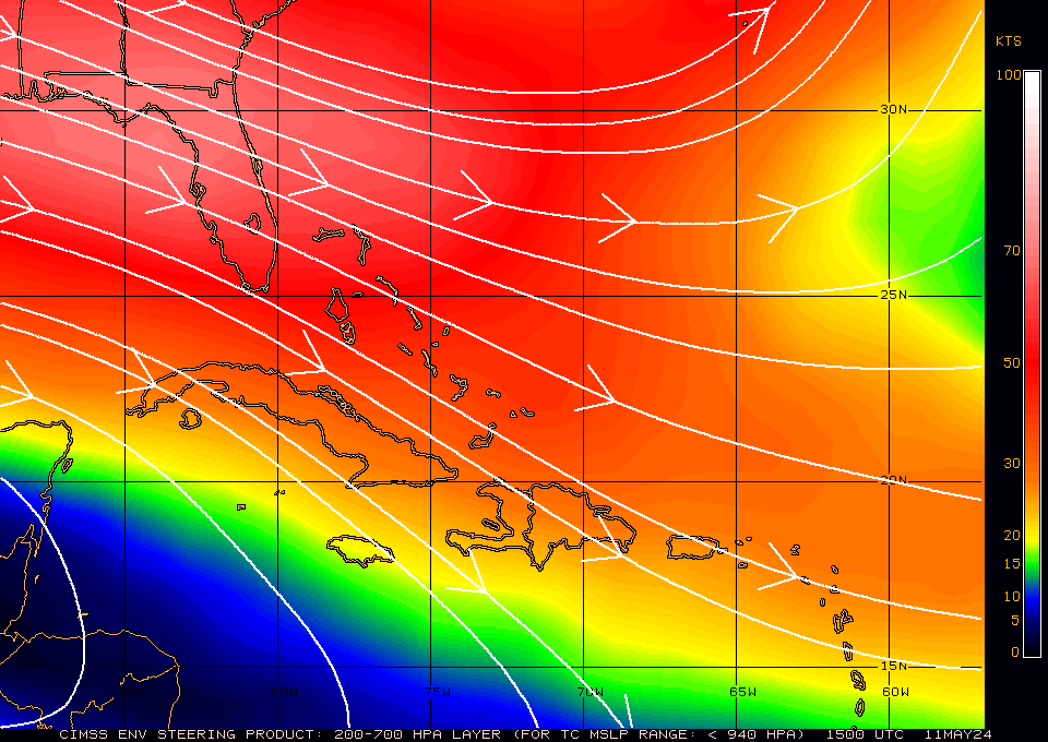
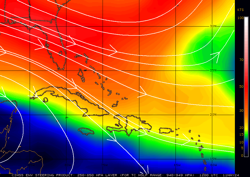
Huracán Irma

Re: Huracán Irma - Categoría 4
El modelo militar tiene a Irma con malas intenciones de un posible azote directo a la isla a 30 horas, veremos.
-
StormWatch
- Cat. 3

- Posts: 3755
- Joined: Thu Aug 06, 2015 11:39 am
- Location: Texas, USA
Re: Huracán Irma - Categoría 4
000
WTNT31 KNHC 050536
TCPAT1
BULLETIN
Hurricane Irma Intermediate Advisory Number 23A
NWS National Hurricane Center Miami FL AL112017
200 AM AST Tue Sep 05 2017
...SEVERE HURRICANE IRMA POSES A SERIOUS THREAT TO THE LEEWARD
ISLANDS...
...ALL PREPARATIONS SHOULD BE RUSH TO COMPLETION...
SUMMARY OF 200 AM AST...0600 UTC...INFORMATION
----------------------------------------------
LOCATION...16.6N 56.4W
ABOUT 360 MI...575 KM E OF THE LEEWARD ISLANDS
MAXIMUM SUSTAINED WINDS...145 MPH...235 KM/H
PRESENT MOVEMENT...W OR 270 DEGREES AT 13 MPH...20 KM/H
MINIMUM CENTRAL PRESSURE...939 MB...27.73 INCHES
WATCHES AND WARNINGS
--------------------
CHANGES WITH THIS ADVISORY:
None.
SUMMARY OF WATCHES AND WARNINGS IN EFFECT:
A Hurricane Warning is in effect for...
* Antigua, Barbuda, Anguilla, Montserrat, St. Kitts, and Nevis
* Saba, St. Eustatius, and Sint Maarten
* Saint Martin and Saint Barthelemy
* British Virgin Islands
* U.S. Virgin Islands
* Puerto Rico, Vieques, and Culebra
A Hurricane Watch is in effect for...
* Guadeloupe
A Tropical Storm Warning is in effect for...
* Guadeloupe
A Tropical Storm Watch is in effect for...
* Dominica
A Hurricane Warning means that hurricane conditions are expected
somewhere within the warning area. A warning is typically issued
36 hours before the anticipated first occurrence of tropical-storm-
force winds, conditions that make outside preparations difficult or
dangerous. Preparations to protect life and property should be
rushed to completion.
A Hurricane Watch means that hurricane conditions are possible
within the watch area. A watch is typically issued 48 hours before
the anticipated first occurrence of tropical-storm-force winds,
conditions that make outside preparations difficult or dangerous.
A Tropical Storm Warning means that tropical storm conditions are
expected somewhere within the warning area within 36 hours.
A Tropical Storm Watch means that tropical storm conditions are
possible within the watch area, generally within 48 hours.
Interests in the Dominican Republic, Haiti, the Turks and Caicos
Islands, Cuba, and the southeastern and central Bahamas should
monitor the progress of Irma.
For storm information specific to your area in the United States,
including possible inland watches and warnings, please monitor
products issued by your local National Weather Service forecast
office. For storm information specific to your area outside the
United States, please monitor products issued by your national
meteorological service.
DISCUSSION AND 48-HOUR OUTLOOK
------------------------------
At 200 AM AST (0600 UTC), the eye of Hurricane Irma was located by
an Air Force Hurricane Hunter aircraft near latitude 16.6 North,
longitude 56.4 West. Irma is moving toward the west near 13 mph
(20 km/h), and this general motion is expected to continue today,
followed by a turn toward the west-northwest Tuesday night.
On the forecast track, the center of Irma will move near or over
portions of the northern Leeward Islands Tuesday night and early
Wednesday.
Data from an Air Force Hurricane Hunter plane indicate that
the maximum sustained winds have increased to near 145 mph (235
km/h) with higher gusts. Irma is a category 4 hurricane on the
Saffir-Simpson Hurricane Wind Scale. Additional strengthening is
possible during the next 48 hours.
Hurricane-force winds extend outward up to 45 miles (75 km) from
the center and tropical-storm-force winds extend outward up to 140
miles (220 km).
The minimum central pressure just estimated from a Hurricane Hunter
plane was 939 mb (27.73 inches).
HAZARDS AFFECTING LAND
----------------------
STORM SURGE: The combination of a dangerous storm surge and large
breaking waves will raise water levels by as much as 6 to 9 feet
above normal tide levels along the coasts of the extreme northern
Leeward Islands within the hurricane warning area near and to the
north of the center of Irma. Near the coast, the surge will be
accompanied by large and destructive waves.
The combination of a dangerous storm surge and the tide will cause
normally dry areas near the coast to be flooded by rising waters
moving inland from the shoreline. The water is expected to reach
the following heights above ground if the peak surge occurs at the
time of high tide...
British and U.S. Virgin Islands except St. Croix...4 to 6 ft
Northern coast of Puerto Rico...2 to 4 ft
Southern coast of Puerto Rico and St. Croix...1 to 2 ft
The deepest water will occur along the immediate coast in areas of
onshore winds, where the surge will be accompanied by large and
destructive waves. Surge-related flooding depends on the relative
timing of the surge and the tidal cycle, and can vary greatly over
short distances. For information specific to your area, please see
products issued by your local National Weather Service forecast
office.
WIND: Hurricane conditions are expected within the hurricane
warning area by Tuesday night, with tropical storm conditions
beginning earlier during the day. Tropical storm conditions are
expected within the tropical storm warning area where hurricane
conditions are also possible.
RAINFALL: Irma is expected to produce total rainfall accumulations
of 3 to 6 inches with isolated maximum amounts of 10 inches across
the northern Leeward Islands, the British and U.S. Virgin Islands,
and Puerto Rico. These rainfall amounts may cause life-threatening
flash floods and mudslides.
SURF: Swells generated by Irma will affect the northern Leeward
Islands, Puerto Rico, and the U.S. and British Virgin Islands
during the next several days. These swells are likely to cause
life-threatening surf and rip current conditions. Please consult
products from your local weather office.
NEXT ADVISORY
-------------
Next complete advisory at 500 AM AST.
$$
Forecaster Avila
Member Since 2005
For official information, please refer to NHC: https://www.nhc.noaa.gov
Hurricane’s hit Puerto Rico:
San Felipe 1928, San Ciprián 1932, Santa Clara 1956, Hugo 1989, Marilyn 1995, Hortense 1996, Georges 1998, Maria 2017, Fiona 2022
Model Runs:
GFS:
[5:30 AM/PM, 11:30 AM/PM]
HWRF, GFDL, UKMET, NAVGEM:
[6:30-8:00 AM/PM, 12:30-2:00 AM/PM]
ECMWF:
[1:45 AM/PM]
Re: Huracán Irma - Categoría 4
Si...vientos de tormenta Tropical...es lo oficial hasta tanto y cuando el ciclon se mueva sobre la linea proyectada. 
Por eso!
Es una proyeccion del centro de meteorologia, confiamos en eso...pero mantenemos los ojos abiertos, de aqui pa abajo habla el satelite, aunque se le pelen los ojos a uno.
Por eso!
Es una proyeccion del centro de meteorologia, confiamos en eso...pero mantenemos los ojos abiertos, de aqui pa abajo habla el satelite, aunque se le pelen los ojos a uno.

Re: Huracán Irma - Categoría 4
Que raro..David1979 wrote: ↑Tue Sep 05, 2017 1:30 am A donde se fueron las bnadas exteriores del sistema?
Se ha compactado...lo que debe estar pasando cerca de ese nucleo!...habra gente que desee estar cerca de eso?
Que mal!
No tiene buen aspecto...ya como que no da gracia.
Sigue sin "olfatear" la baja presion.
Seguire aqui por media hora mas...no da signos de que desacelera...
a menos que aun este sintiendo esta
Re: Huracán Irma - Categoría 4
2:00 AM AST Tue Sep 5
Location: 16.6°N 56.4°W
Moving: W at 13 mph
Min pressure: 939 mb
Max sustained: 145 mph
Location: 16.6°N 56.4°W
Moving: W at 13 mph
Min pressure: 939 mb
Max sustained: 145 mph
-
StormWatch
- Cat. 3
- Posts: 3755
- Joined: Thu Aug 06, 2015 11:39 am
- Location: Texas, USA
Re: Huracán Irma - Categoría 4
Yo creo QUE BAJOOOOO 
Member Since 2005
For official information, please refer to NHC: https://www.nhc.noaa.gov
Hurricane’s hit Puerto Rico:
San Felipe 1928, San Ciprián 1932, Santa Clara 1956, Hugo 1989, Marilyn 1995, Hortense 1996, Georges 1998, Maria 2017, Fiona 2022
Model Runs:
GFS:
[5:30 AM/PM, 11:30 AM/PM]
HWRF, GFDL, UKMET, NAVGEM:
[6:30-8:00 AM/PM, 12:30-2:00 AM/PM]
ECMWF:
[1:45 AM/PM]
For official information, please refer to NHC: https://www.nhc.noaa.gov
Hurricane’s hit Puerto Rico:
San Felipe 1928, San Ciprián 1932, Santa Clara 1956, Hugo 1989, Marilyn 1995, Hortense 1996, Georges 1998, Maria 2017, Fiona 2022
Model Runs:
GFS:
[5:30 AM/PM, 11:30 AM/PM]
HWRF, GFDL, UKMET, NAVGEM:
[6:30-8:00 AM/PM, 12:30-2:00 AM/PM]
ECMWF:
[1:45 AM/PM]
Re: Huracán Irma - Categoría 4
Bajo un grado 16.6n y 56.4w 
Re: Huracán Irma - Categoría 4
StormWatch wrote: ↑Tue Sep 05, 2017 1:38 am 000
WTNT31 KNHC 050536
TCPAT1
BULLETIN
Hurricane Irma Intermediate Advisory Number 23A
NWS National Hurricane Center Miami FL AL112017
200 AM AST Tue Sep 05 2017
igual que mostraba el UKM
-
Hortense69
- Invest

- Posts: 153
- Joined: Tue Aug 06, 2013 11:52 pm
Re: Huracán Irma - Categoría 4
David 79...David1979 wrote: ↑Tue Sep 05, 2017 1:12 am Hay una leyenda urbana que escuho desde que era muchacho...bueno, quizas no tanto.
Yo he escuchado decir a mas de un "meteorologo" de pasillo decir que a veces. no siempre, pero a veces, los C5 crean a en su entorno como un cierto tipo de environment o ambiente donde se sienten a gusto y en ocasiones generan como que algun tipo de alta presion, aunque no aparezca en los mapas, regularmente en el cuadrante norte.__Rumores deben ser...vainas de la gente, nunca me ha dao por investigar semejante rumor a fondo.
Ese rumor es viejo! Muy cierto! No solo crean su propio entorno, cargan su propio oxigeno.... Como el asmatico que anda con ventilador y oxigeno
[i]El mejor pronóstico.... Las Horas...
[/i]
Mi opinión es de aficionada miramapas. Para información oficial favor dirigirse a: http://www.nhc.noaa.gov/
[/i]
Mi opinión es de aficionada miramapas. Para información oficial favor dirigirse a: http://www.nhc.noaa.gov/