
Huracán Irma

Re: Huracan Irma - Categoría 3
Luego de publicar mi opinión vi la del compañero Carlos y estoy TOTALMENTE DE ACUERDO. Por favor! Cordura, la palabrita "Next" esta de mas y de sobra en estos momentos. Hay que seguir monitoreando de cerca al sistema.
-
StormWatch
- Cat. 3

- Posts: 3755
- Joined: Thu Aug 06, 2015 11:39 am
- Location: Texas, USA
Re: Huracan Irma - Categoría 3
12z reciente
Member Since 2005
For official information, please refer to NHC: https://www.nhc.noaa.gov
Hurricane’s hit Puerto Rico:
San Felipe 1928, San Ciprián 1932, Santa Clara 1956, Hugo 1989, Marilyn 1995, Hortense 1996, Georges 1998, Maria 2017, Fiona 2022
Model Runs:
GFS:
[5:30 AM/PM, 11:30 AM/PM]
HWRF, GFDL, UKMET, NAVGEM:
[6:30-8:00 AM/PM, 12:30-2:00 AM/PM]
ECMWF:
[1:45 AM/PM]
Re: Huracan Irma - Categoría 3
Hasta el domingo o Lunes no se debe bajar la guardia, máximo cuando aún no ha comenzado su movimiento al suroeste. La tormenta Jeanne nos tomó de sorpresa, fue tanta la sorpresa que yo tenía un familiar en Centro Médico y me tuvieron que refugiar en el segundo piso. Desde ese día no confío.

Re: Huracan Irma - Categoría 3
BULLETIN
Hurricane Irma Advisory Number 9
NWS National Hurricane Center Miami FL AL112017
1100 AM AST Fri Sep 01 2017
...IRMA FORECAST TO REMAIN A POWERFUL HURRICANE FOR DAYS...
SUMMARY OF 1100 AM AST...1500 UTC...INFORMATION
-----------------------------------------------
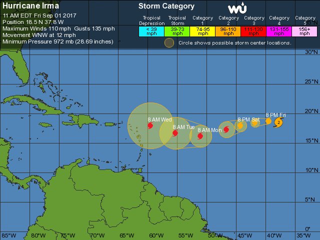
LOCATION...18.5N 37.8W
ABOUT 1580 MI...2540 KM E OF THE LEEWARD ISLANDS
MAXIMUM SUSTAINED WINDS...110 MPH...175 KM/H
PRESENT MOVEMENT...WNW OR 285 DEGREES AT 13 MPH...20 KM/H
MINIMUM CENTRAL PRESSURE...972 MB...28.71 INCHES
WATCHES AND WARNINGS
--------------------
There are no coastal watches or warnings in effect.
DISCUSSION AND 48-HOUR OUTLOOK
------------------------------
At 1100 AM AST (1500 UTC), the center of Hurricane Irma was located
near latitude 18.5 North, longitude 37.8 West. Irma is moving toward
the west-northwest near 13 mph (20 km/h). A turn toward the west is
expected by tonight, followed by a turn toward the west-southwest on
Saturday.
Maximum sustained winds are near 110 mph (175 km/h) with higher
gusts. Fluctuations in strength, up or down, are possible during
the next few days, but Irma is expected to remain a powerful
hurricane through the weekend.
Hurricane-force winds extend outward up to 15 miles (30 km) from the
center and tropical-storm-force winds extend outward up to 90 miles
(150 km).
The estimated minimum central pressure is 972 mb (28.71 inches).
HAZARDS AFFECTING LAND
----------------------
None
NEXT ADVISORY
-------------
Next complete advisory at 500 PM AST.
$$
Forecaster Blake
NNNN
Hurricane Irma Advisory Number 9
NWS National Hurricane Center Miami FL AL112017
1100 AM AST Fri Sep 01 2017
...IRMA FORECAST TO REMAIN A POWERFUL HURRICANE FOR DAYS...
SUMMARY OF 1100 AM AST...1500 UTC...INFORMATION
-----------------------------------------------
LOCATION...18.5N 37.8W
ABOUT 1580 MI...2540 KM E OF THE LEEWARD ISLANDS
MAXIMUM SUSTAINED WINDS...110 MPH...175 KM/H
PRESENT MOVEMENT...WNW OR 285 DEGREES AT 13 MPH...20 KM/H
MINIMUM CENTRAL PRESSURE...972 MB...28.71 INCHES
WATCHES AND WARNINGS
--------------------
There are no coastal watches or warnings in effect.
DISCUSSION AND 48-HOUR OUTLOOK
------------------------------
At 1100 AM AST (1500 UTC), the center of Hurricane Irma was located
near latitude 18.5 North, longitude 37.8 West. Irma is moving toward
the west-northwest near 13 mph (20 km/h). A turn toward the west is
expected by tonight, followed by a turn toward the west-southwest on
Saturday.
Maximum sustained winds are near 110 mph (175 km/h) with higher
gusts. Fluctuations in strength, up or down, are possible during
the next few days, but Irma is expected to remain a powerful
hurricane through the weekend.
Hurricane-force winds extend outward up to 15 miles (30 km) from the
center and tropical-storm-force winds extend outward up to 90 miles
(150 km).
The estimated minimum central pressure is 972 mb (28.71 inches).
HAZARDS AFFECTING LAND
----------------------
None
NEXT ADVISORY
-------------
Next complete advisory at 500 PM AST.
$$
Forecaster Blake
NNNN
emh- huracan es simplemente ahora Edgardo. Importante: Phil Klotzbach, recordó que "el mejor momento para prepararse para los huracanes es cuando todavía no hay huracanes".
Re: Huracan Irma - Categoría 3
Hurricane Irma Discussion Number 9
NWS National Hurricane Center Miami FL AL112017
1100 AM AST Fri Sep 01 2017
Irma is undergoing an eyewall replacement cycle. The small eye is
becoming less distinct, with both microwave and visible imagery
indicating the presence of a forming outer eyewall. Satellite
intensity estimates are lower, so the initial wind speed is reduced
to 95 kt. Some further weakening is possible over the next day or
so while Irma moves over marginally warm SSTs and continues the
eyewall replacement. After that time, the environment should be
generally conducive for some restrengthening, although forecasting
the timing of eyewall replacement cycles is next to impossible. The
biggest change from yesterday are the long-term wind shear
predictions from the global models, which shows a little more shear.
Still, the shear is not that strong, and the hurricane will be
moving over 29C SSTs. Thus, the NHC intensity forecast is reduced
somewhat from the previous one, but remains near or slightly above
the model consensus.
Irma has turned a little bit to the left, now estimated to be
moving 285/11. The general synoptic situation remains well
established due to a building mid-level high, which should cause
the hurricane to turn westward later today and then move
west-southwestward through the weekend. An upper-level low will be
dropping southward on the east side of that high, and should be a
key feature to how far south Irma goes before eventually turning
westward and west-northwestward early next week. There is a
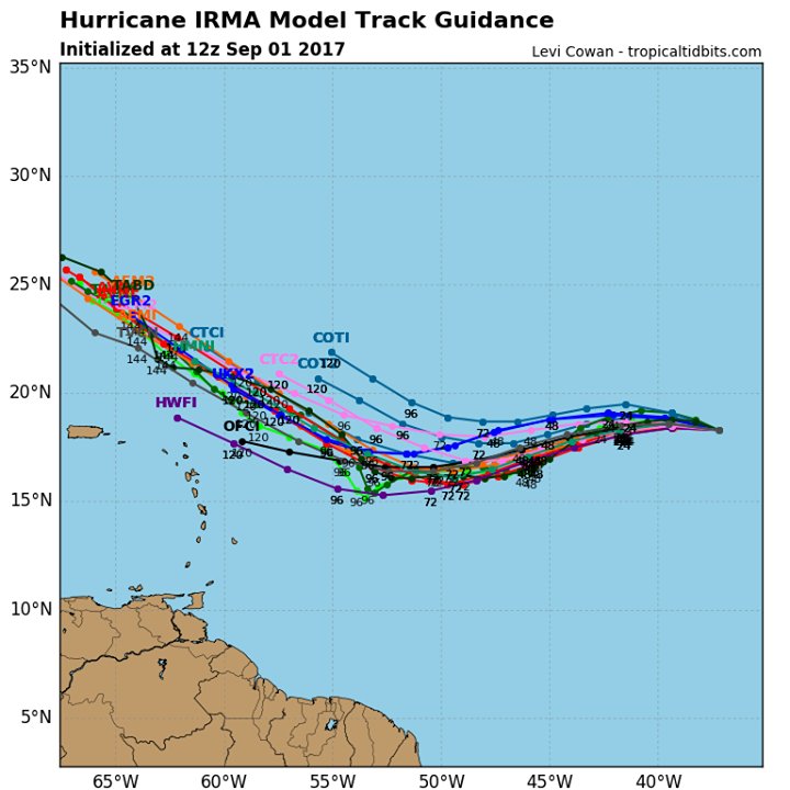
noticeable clustering of guidance by day 5, with the ECMWF, HWRF and
corrected-consensus models to the south, and the UKMET, GFS, CTC and
HMON to the north. Since Irma is forecast to be a vertically deep
cyclone, it seems more likely to respond to the northerly flow from
the upper-level low, which leads me to believe the track will be on
the southern side of the guidance. Thus, the forecast will stay
similar to the previous one, very close to the southern cluster
mentioned above.
FORECAST POSITIONS AND MAX WINDS
INIT 01/1500Z 18.5N 37.8W 95 KT 110 MPH
12H 02/0000Z 18.7N 39.5W 90 KT 105 MPH
24H 02/1200Z 18.5N 41.8W 90 KT 105 MPH
36H 03/0000Z 18.0N 44.2W 95 KT 110 MPH
48H 03/1200Z 17.3N 46.6W 100 KT 115 MPH
72H 04/1200Z 16.2N 51.0W 105 KT 120 MPH
96H 05/1200Z 16.7N 55.2W 110 KT 125 MPH
120H 06/1200Z 18.0N 59.5W 110 KT 125 MPH
$$
Forecaster Blake
NWS National Hurricane Center Miami FL AL112017
1100 AM AST Fri Sep 01 2017
Irma is undergoing an eyewall replacement cycle. The small eye is
becoming less distinct, with both microwave and visible imagery
indicating the presence of a forming outer eyewall. Satellite
intensity estimates are lower, so the initial wind speed is reduced
to 95 kt. Some further weakening is possible over the next day or
so while Irma moves over marginally warm SSTs and continues the
eyewall replacement. After that time, the environment should be
generally conducive for some restrengthening, although forecasting
the timing of eyewall replacement cycles is next to impossible. The
biggest change from yesterday are the long-term wind shear
predictions from the global models, which shows a little more shear.
Still, the shear is not that strong, and the hurricane will be
moving over 29C SSTs. Thus, the NHC intensity forecast is reduced
somewhat from the previous one, but remains near or slightly above
the model consensus.
Irma has turned a little bit to the left, now estimated to be
moving 285/11. The general synoptic situation remains well
established due to a building mid-level high, which should cause
the hurricane to turn westward later today and then move
west-southwestward through the weekend. An upper-level low will be
dropping southward on the east side of that high, and should be a
key feature to how far south Irma goes before eventually turning
westward and west-northwestward early next week. There is a
noticeable clustering of guidance by day 5, with the ECMWF, HWRF and
corrected-consensus models to the south, and the UKMET, GFS, CTC and
HMON to the north. Since Irma is forecast to be a vertically deep
cyclone, it seems more likely to respond to the northerly flow from
the upper-level low, which leads me to believe the track will be on
the southern side of the guidance. Thus, the forecast will stay
similar to the previous one, very close to the southern cluster
mentioned above.
FORECAST POSITIONS AND MAX WINDS
INIT 01/1500Z 18.5N 37.8W 95 KT 110 MPH
12H 02/0000Z 18.7N 39.5W 90 KT 105 MPH
24H 02/1200Z 18.5N 41.8W 90 KT 105 MPH
36H 03/0000Z 18.0N 44.2W 95 KT 110 MPH
48H 03/1200Z 17.3N 46.6W 100 KT 115 MPH
72H 04/1200Z 16.2N 51.0W 105 KT 120 MPH
96H 05/1200Z 16.7N 55.2W 110 KT 125 MPH
120H 06/1200Z 18.0N 59.5W 110 KT 125 MPH
$$
Forecaster Blake
emh- huracan es simplemente ahora Edgardo. Importante: Phil Klotzbach, recordó que "el mejor momento para prepararse para los huracanes es cuando todavía no hay huracanes".
-
StormWatch
- Cat. 3
- Posts: 3755
- Joined: Thu Aug 06, 2015 11:39 am
- Location: Texas, USA
Re: Huracan Irma - Categoría 3
En la 18 ya! Yessssssssssssssssssssss!
Member Since 2005
For official information, please refer to NHC: https://www.nhc.noaa.gov
Hurricane’s hit Puerto Rico:
San Felipe 1928, San Ciprián 1932, Santa Clara 1956, Hugo 1989, Marilyn 1995, Hortense 1996, Georges 1998, Maria 2017, Fiona 2022
Model Runs:
GFS:
[5:30 AM/PM, 11:30 AM/PM]
HWRF, GFDL, UKMET, NAVGEM:
[6:30-8:00 AM/PM, 12:30-2:00 AM/PM]
ECMWF:
[1:45 AM/PM]
For official information, please refer to NHC: https://www.nhc.noaa.gov
Hurricane’s hit Puerto Rico:
San Felipe 1928, San Ciprián 1932, Santa Clara 1956, Hugo 1989, Marilyn 1995, Hortense 1996, Georges 1998, Maria 2017, Fiona 2022
Model Runs:
GFS:
[5:30 AM/PM, 11:30 AM/PM]
HWRF, GFDL, UKMET, NAVGEM:
[6:30-8:00 AM/PM, 12:30-2:00 AM/PM]
ECMWF:
[1:45 AM/PM]

Re: Huracan Irma - Categoría 3
Pero no querias que pasara por la isla?
-
StormWatch
- Cat. 3
- Posts: 3755
- Joined: Thu Aug 06, 2015 11:39 am
- Location: Texas, USA
Re: Huracan Irma - Categoría 3
Tu quieres q nos azote un Categoría 4 o 5?
Member Since 2005
For official information, please refer to NHC: https://www.nhc.noaa.gov
Hurricane’s hit Puerto Rico:
San Felipe 1928, San Ciprián 1932, Santa Clara 1956, Hugo 1989, Marilyn 1995, Hortense 1996, Georges 1998, Maria 2017, Fiona 2022
Model Runs:
GFS:
[5:30 AM/PM, 11:30 AM/PM]
HWRF, GFDL, UKMET, NAVGEM:
[6:30-8:00 AM/PM, 12:30-2:00 AM/PM]
ECMWF:
[1:45 AM/PM]
For official information, please refer to NHC: https://www.nhc.noaa.gov
Hurricane’s hit Puerto Rico:
San Felipe 1928, San Ciprián 1932, Santa Clara 1956, Hugo 1989, Marilyn 1995, Hortense 1996, Georges 1998, Maria 2017, Fiona 2022
Model Runs:
GFS:
[5:30 AM/PM, 11:30 AM/PM]
HWRF, GFDL, UKMET, NAVGEM:
[6:30-8:00 AM/PM, 12:30-2:00 AM/PM]
ECMWF:
[1:45 AM/PM]
-
StormWatch
- Cat. 3
- Posts: 3755
- Joined: Thu Aug 06, 2015 11:39 am
- Location: Texas, USA
Re: Huracan Irma - Categoría 3

Member Since 2005
For official information, please refer to NHC: https://www.nhc.noaa.gov
Hurricane’s hit Puerto Rico:
San Felipe 1928, San Ciprián 1932, Santa Clara 1956, Hugo 1989, Marilyn 1995, Hortense 1996, Georges 1998, Maria 2017, Fiona 2022
Model Runs:
GFS:
[5:30 AM/PM, 11:30 AM/PM]
HWRF, GFDL, UKMET, NAVGEM:
[6:30-8:00 AM/PM, 12:30-2:00 AM/PM]
ECMWF:
[1:45 AM/PM]
For official information, please refer to NHC: https://www.nhc.noaa.gov
Hurricane’s hit Puerto Rico:
San Felipe 1928, San Ciprián 1932, Santa Clara 1956, Hugo 1989, Marilyn 1995, Hortense 1996, Georges 1998, Maria 2017, Fiona 2022
Model Runs:
GFS:
[5:30 AM/PM, 11:30 AM/PM]
HWRF, GFDL, UKMET, NAVGEM:
[6:30-8:00 AM/PM, 12:30-2:00 AM/PM]
ECMWF:
[1:45 AM/PM]
Re: Huracan Irma - Categoría 3
Saludos:
Esperemos siga subiendo. Muchachos atentos el fin de semana largo para evitar sorpresas con el movimiento proyectado wsw. Pendientes me entretiene esto pero algo asi de fuerte asusta cerca de nuestra islita.
Si llamo la atencion que compañias de venta de generadores estan utilizando la imagen de ayer donde habia azote directo para mi meter miedo y que salgan corriendo a comprar.
Precaucion a todos y mucho juicio.