Huracán Matthew
-
huracan_1975
- Tormenta Tropical

- Posts: 630
- Joined: Sun Aug 16, 2015 9:59 am
Re: Invest 97L al suroeste de Cabo Verde 20%-80%
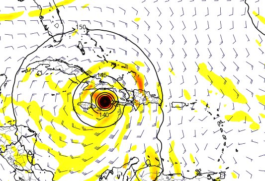
el GFS 12Z.. con cambios a esta hora se mueve mas lento y un giro mas la norte que en corridas anteriores 168 horas cerca de haiti y este cuba , pero mas por este de cuba al fin el GFS ve el frente frio y la vaguada al norte de esta . eso lo hara girar mas al norte que al oeste .... se une an algo al Europeo de 00z ..


Last edited by huracan_1975 on Sun Sep 25, 2016 12:35 pm, edited 1 time in total.
-
StormWatch
- Cat. 3

- Posts: 3755
- Joined: Thu Aug 06, 2015 11:39 am
- Location: Texas, USA
Re: Invest 97L al suroeste de Cabo Verde 20%-80%
Via Twitter: CycloforumsPR
@CycloforumsPR
Modelo GFS 12z sorprende con una cambio alguito similar al del Europeo. Sube al futuro Matthews entre Haití y Jamaica.

@CycloforumsPR
Modelo GFS 12z sorprende con una cambio alguito similar al del Europeo. Sube al futuro Matthews entre Haití y Jamaica.

Member Since 2005
For official information, please refer to NHC: https://www.nhc.noaa.gov
Hurricane’s hit Puerto Rico:
San Felipe 1928, San Ciprián 1932, Santa Clara 1956, Hugo 1989, Marilyn 1995, Hortense 1996, Georges 1998, Maria 2017, Fiona 2022
Model Runs:
GFS:
[5:30 AM/PM, 11:30 AM/PM]
HWRF, GFDL, UKMET, NAVGEM:
[6:30-8:00 AM/PM, 12:30-2:00 AM/PM]
ECMWF:
[1:45 AM/PM]
-
huracan_1975
- Tormenta Tropical

- Posts: 630
- Joined: Sun Aug 16, 2015 9:59 am
Re: Invest 97L al suroeste de Cabo Verde 20%-80%
el CMC o Gem 12Z.. 126 horas Mas fuerte y algo mas al oeste veremos como termina


-
huracan_1975
- Tormenta Tropical

- Posts: 630
- Joined: Sun Aug 16, 2015 9:59 am
Re: Invest 97L al suroeste de Cabo Verde 20%-80%
EL CMC O GEM 12z. se une al EURO , GFS ....192 horas .....


Re: Invest 97L al suroeste de Cabo Verde 20%-80%
sera que el modelo NAGVEM siempre tenia la razon
Re: Invest 97L al suroeste de Cabo Verde 20%-80%
GFS, Europeo, CMC y Navgem hacen más interesante el escenario, mientras el 97L parece ajustarse hacia los 8+ grados de latitud.


Siempre la Madre Naturaleza es la última que ríe.
-
StormWatch
- Cat. 3

- Posts: 3755
- Joined: Thu Aug 06, 2015 11:39 am
- Location: Texas, USA
Re: Invest 97L al suroeste de Cabo Verde 20%-80%
Subiooooooooo 30%-90%
Showers and thunderstorms associated with a low pressure area about
1500 miles east-southeast of the Windward Islands are showing some
signs of organization. Environmental conditions are expected to be
conducive for gradual development, and a tropical depression is
likely to form later this week while the low moves westward to west-
northwestward at 15 to 20 mph. Interests in the Windward Islands,
the southeastern and south-central Caribbean Sea, as well as the
northern coast of South America, should monitor the progress of this
system.
* Formation chance through 48 hours...low...30 percent
* Formation chance through 5 days...high...90 percent
Member Since 2005
For official information, please refer to NHC: https://www.nhc.noaa.gov
Hurricane’s hit Puerto Rico:
San Felipe 1928, San Ciprián 1932, Santa Clara 1956, Hugo 1989, Marilyn 1995, Hortense 1996, Georges 1998, Maria 2017, Fiona 2022
Model Runs:
GFS:
[5:30 AM/PM, 11:30 AM/PM]
HWRF, GFDL, UKMET, NAVGEM:
[6:30-8:00 AM/PM, 12:30-2:00 AM/PM]
ECMWF:
[1:45 AM/PM]
For official information, please refer to NHC: https://www.nhc.noaa.gov
Hurricane’s hit Puerto Rico:
San Felipe 1928, San Ciprián 1932, Santa Clara 1956, Hugo 1989, Marilyn 1995, Hortense 1996, Georges 1998, Maria 2017, Fiona 2022
Model Runs:
GFS:
[5:30 AM/PM, 11:30 AM/PM]
HWRF, GFDL, UKMET, NAVGEM:
[6:30-8:00 AM/PM, 12:30-2:00 AM/PM]
ECMWF:
[1:45 AM/PM]
-
huracan_1975
- Tormenta Tropical

- Posts: 630
- Joined: Sun Aug 16, 2015 9:59 am
Re: Invest 97L al suroeste de Cabo Verde 20%-80%
ZCZC MIATWOAT ALL
TTAA00 KNHC DDHHMM
TROPICAL WEATHER OUTLOOK
NWS NATIONAL HURRICANE CENTER MIAMI FL
200 PM EDT SUN SEP 25 2016
For the North Atlantic...Caribbean Sea and the Gulf of Mexico:
The National Hurricane Center has issued the last advisory on
Post-Tropical Storm Karl, located several hundred miles south-
southeast of Cape Race, Newfoundland.
1. Showers and thunderstorms associated with a low pressure area about
1500 miles east-southeast of the Windward Islands are showing some
signs of organization. Environmental conditions are expected to be
conducive for gradual development, and a tropical depression is
likely to form later this week while the low moves westward to west-
northwestward at 15 to 20 mph. Interests in the Windward Islands,
the southeastern and south-central Caribbean Sea, as well as the
northern coast of South America, should monitor the progress of this
system.
* Formation chance through 48 hours...low...30 percent

* Formation chance through 5 days...high...90 percent
Forecaster Kimberlain
TTAA00 KNHC DDHHMM
TROPICAL WEATHER OUTLOOK
NWS NATIONAL HURRICANE CENTER MIAMI FL
200 PM EDT SUN SEP 25 2016
For the North Atlantic...Caribbean Sea and the Gulf of Mexico:
The National Hurricane Center has issued the last advisory on
Post-Tropical Storm Karl, located several hundred miles south-
southeast of Cape Race, Newfoundland.
1. Showers and thunderstorms associated with a low pressure area about
1500 miles east-southeast of the Windward Islands are showing some
signs of organization. Environmental conditions are expected to be
conducive for gradual development, and a tropical depression is
likely to form later this week while the low moves westward to west-
northwestward at 15 to 20 mph. Interests in the Windward Islands,
the southeastern and south-central Caribbean Sea, as well as the
northern coast of South America, should monitor the progress of this
system.
* Formation chance through 48 hours...low...30 percent

* Formation chance through 5 days...high...90 percent
Forecaster Kimberlain
-
StormWatch
- Cat. 3

- Posts: 3755
- Joined: Thu Aug 06, 2015 11:39 am
- Location: Texas, USA
Re: Invest 97L al suroeste de Cabo Verde 20%-80%
Ese cono muy estrecho.......???????

Member Since 2005
For official information, please refer to NHC: https://www.nhc.noaa.gov
Hurricane’s hit Puerto Rico:
San Felipe 1928, San Ciprián 1932, Santa Clara 1956, Hugo 1989, Marilyn 1995, Hortense 1996, Georges 1998, Maria 2017, Fiona 2022
Model Runs:
GFS:
[5:30 AM/PM, 11:30 AM/PM]
HWRF, GFDL, UKMET, NAVGEM:
[6:30-8:00 AM/PM, 12:30-2:00 AM/PM]
ECMWF:
[1:45 AM/PM]
For official information, please refer to NHC: https://www.nhc.noaa.gov
Hurricane’s hit Puerto Rico:
San Felipe 1928, San Ciprián 1932, Santa Clara 1956, Hugo 1989, Marilyn 1995, Hortense 1996, Georges 1998, Maria 2017, Fiona 2022
Model Runs:
GFS:
[5:30 AM/PM, 11:30 AM/PM]
HWRF, GFDL, UKMET, NAVGEM:
[6:30-8:00 AM/PM, 12:30-2:00 AM/PM]
ECMWF:
[1:45 AM/PM]
Re: Invest 97L al suroeste de Cabo Verde 20%-80%
El cono es de formación ni de trayectoria final.
Siempre recuerden esto:
Los sistemas tropicales no se mueven en linea recta, se mueven es "zig-zag", o oscilaciones. Es normal que este a 290 grados y de momento vaya a 270 grados, esto hace un promedio de 280 grados, lo cual es Oeste-Noroeste. Es normal.
Los sistemas tropicales no se mueven en linea recta, se mueven es "zig-zag", o oscilaciones. Es normal que este a 290 grados y de momento vaya a 270 grados, esto hace un promedio de 280 grados, lo cual es Oeste-Noroeste. Es normal.

