
Pido opinion de los sabios de este foro.
¿Esta informacion de esta mañana va en acorde con lo que se esta discutiendo?
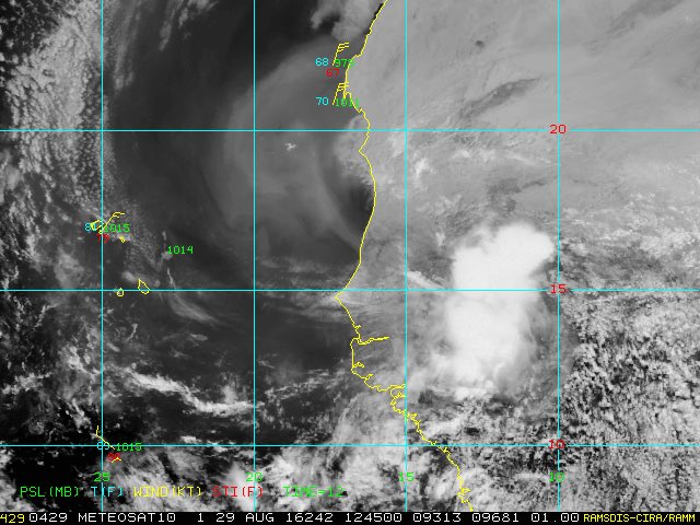
New Tropical Wave Will Move Into The Eastern Atlantic Tonight Will Need To Be Monitored Closely:
A tropical wave is expected to move off of the coast of Africa into the eastern Atlantic tonight. Environmental conditions are forecast to be favorable for this tropical wave to slowly develop during the middle and last part of this week. This is a tropical wave that will need to be monitored very closely as the upper level pattern is favorable for this system to not only become a tropical storm and possibly even a hurricane, but also be driven westward underneath a large area of high pressure. In particular, those of you in the northern Lesser Antilles, Virgin Islands and Puerto Rico should closely monitor this new tropical wave as it is currently forecast to move across these areas around next Monday.
At this point, I want to see how organized this tropical wave is when it moves into the eastern Atlantic and then go from there. If we do see a large ridge of high pressure set up across the Atlantic, then this is a system that may really need to be watched, not only for the eastern Caribbean, but also for the Bahamas and the US East Coast. For now, however, it is something to just watch.
SOURCE: Crown Weather Services
Opinen para que los que estamos aprendiendo en Cycloforums...
Invest 92L al Sur de Florida (Anaranjado 40%-40%)
-
4Ket Radar
- Onda Tropical

- Posts: 9
- Joined: Wed Aug 24, 2016 3:38 pm
-
StormWatch
- Cat. 3

- Posts: 3741
- Joined: Thu Aug 06, 2015 11:39 am
- Location: Texas, USA
Re: 0-50% sistema sobre Africa que modelos desarrollan
Pouch 25L
Move offshore of Africa later today or tonight.
Formation through 5 days 50%

Move offshore of Africa later today or tonight.
Formation through 5 days 50%
Member Since 2005
For official information, please refer to NHC: https://www.nhc.noaa.gov
Hurricane’s hit Puerto Rico:
San Felipe 1928, San Ciprián 1932, Santa Clara 1956, Hugo 1989, Marilyn 1995, Hortense 1996, Georges 1998, Maria 2017, Fiona 2022
Model Runs:
GFS:
[5:30 AM/PM, 11:30 AM/PM]
HWRF, GFDL, UKMET, NAVGEM:
[6:30-8:00 AM/PM, 12:30-2:00 AM/PM]
ECMWF:
[1:45 AM/PM]
-
StormWatch
- Cat. 3
- Posts: 3741
- Joined: Thu Aug 06, 2015 11:39 am
- Location: Texas, USA
Re: 0-50% sistema sobre Africa que modelos desarrollan
Esta NOCHE se tira al charco!
Member Since 2005
For official information, please refer to NHC: https://www.nhc.noaa.gov
Hurricane’s hit Puerto Rico:
San Felipe 1928, San Ciprián 1932, Santa Clara 1956, Hugo 1989, Marilyn 1995, Hortense 1996, Georges 1998, Maria 2017, Fiona 2022
Model Runs:
GFS:
[5:30 AM/PM, 11:30 AM/PM]
HWRF, GFDL, UKMET, NAVGEM:
[6:30-8:00 AM/PM, 12:30-2:00 AM/PM]
ECMWF:
[1:45 AM/PM]
For official information, please refer to NHC: https://www.nhc.noaa.gov
Hurricane’s hit Puerto Rico:
San Felipe 1928, San Ciprián 1932, Santa Clara 1956, Hugo 1989, Marilyn 1995, Hortense 1996, Georges 1998, Maria 2017, Fiona 2022
Model Runs:
GFS:
[5:30 AM/PM, 11:30 AM/PM]
HWRF, GFDL, UKMET, NAVGEM:
[6:30-8:00 AM/PM, 12:30-2:00 AM/PM]
ECMWF:
[1:45 AM/PM]

Re: 0-50% sistema sobre Africa que modelos desarrollan
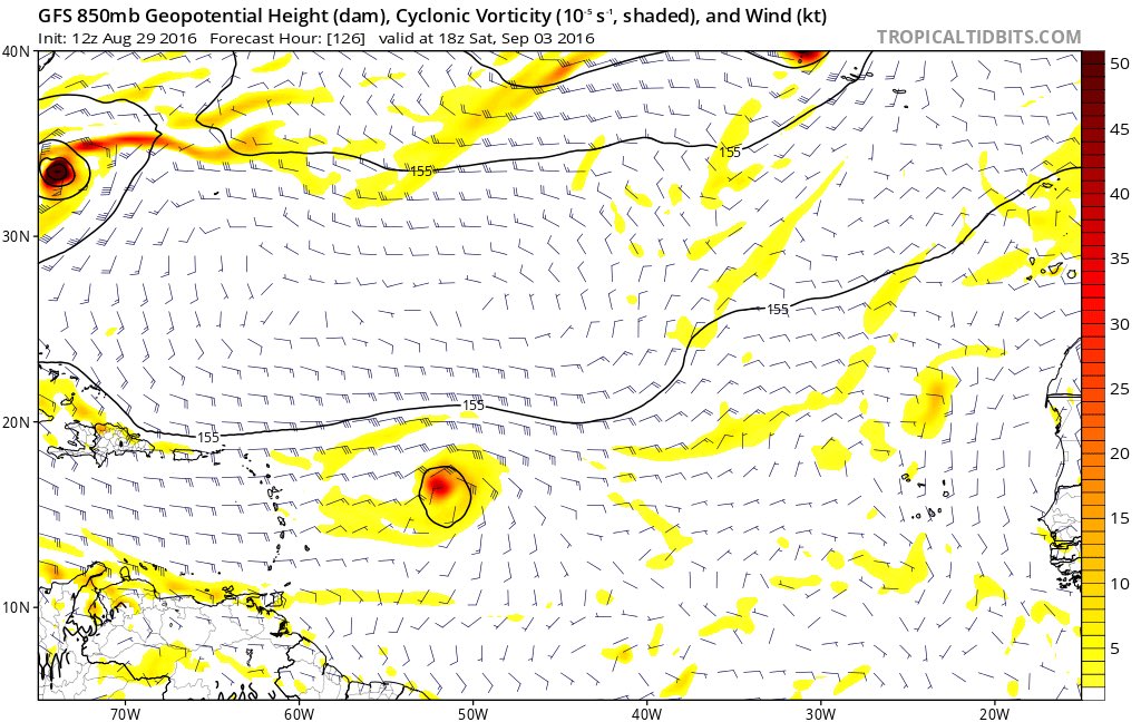
GFS 12z pasa el Centro tocando el Norte de la isla
-
huracan_1975
- Tormenta Tropical

- Posts: 630
- Joined: Sun Aug 16, 2015 9:59 am
Re: 0-50% sistema sobre Africa que modelos desarrollan
el GFS 12Z... sistema entrando por PR. Y RD . como posible huracán del 5 al 6 de sept. 2016 .
-
StormWatch
- Cat. 3
- Posts: 3741
- Joined: Thu Aug 06, 2015 11:39 am
- Location: Texas, USA
Re: 0-50% sistema sobre Africa que modelos desarrollan
Uyyyyy
Member Since 2005
For official information, please refer to NHC: https://www.nhc.noaa.gov
Hurricane’s hit Puerto Rico:
San Felipe 1928, San Ciprián 1932, Santa Clara 1956, Hugo 1989, Marilyn 1995, Hortense 1996, Georges 1998, Maria 2017, Fiona 2022
Model Runs:
GFS:
[5:30 AM/PM, 11:30 AM/PM]
HWRF, GFDL, UKMET, NAVGEM:
[6:30-8:00 AM/PM, 12:30-2:00 AM/PM]
ECMWF:
[1:45 AM/PM]
For official information, please refer to NHC: https://www.nhc.noaa.gov
Hurricane’s hit Puerto Rico:
San Felipe 1928, San Ciprián 1932, Santa Clara 1956, Hugo 1989, Marilyn 1995, Hortense 1996, Georges 1998, Maria 2017, Fiona 2022
Model Runs:
GFS:
[5:30 AM/PM, 11:30 AM/PM]
HWRF, GFDL, UKMET, NAVGEM:
[6:30-8:00 AM/PM, 12:30-2:00 AM/PM]
ECMWF:
[1:45 AM/PM]
-
huracan_1975
- Tormenta Tropical
- Posts: 630
- Joined: Sun Aug 16, 2015 9:59 am
Re: 0-50% sistema sobre Africa que modelos desarrollan
esta trayectoria va ser esencial por lo que ocurra con la TD 9 , ya que si no se muy rápido, la Alta no se establezca rápido . todo depende ahora de la TD9. seria fantástico que la TD 9 se mueva mas a tierra de U.S.A , ose mas por el norte de Florida o Misisipi o mejor aun siga su rumbo al oeste . y se disipe ahí , pero si decide ir por florida que lo haga por el extremo noroeste de florida para que no salga muy activa otro lado del atlántico .
veremos que pasa ......
veremos que pasa ......

Re: 0-50% sistema sobre Africa que modelos desarrollan
es increible que los modelo comensaron madandolo al norte y ahora los traen aqui con mucha lluvia y se movera bien rapido
