El Herbert Box Boricua!
Huracan Fiona Cat 1 - Al sur de Puerto Rico
-
StormWatch
- Cat. 3

- Posts: 3755
- Joined: Thu Aug 06, 2015 11:39 am
- Location: Texas, USA
Re: Tormenta Tropical Fiona al este de las Antillas
Veremos entonces!Georges_98 wrote: ↑Fri Sep 16, 2022 5:25 pmPronostican una ralentización en su velocidad de traslación una vez se divorcie del shear y se disipe la Alta que esta al norte de nosotros. Entonces comenzará a girar al norte y a ganar intensidad. La incertidumbre, hermano StormWatch, es en que punto hará estos dos movimientos.StormWatch wrote: ↑Fri Sep 16, 2022 5:06 pm Mencionó lo anterior pq ahora casi todos los meteorólogos dicen esto:
Fiona is going to impact Puerto Rico/Hispaniola this weekend into early next week.
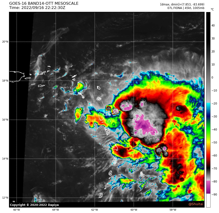
Mientras tanto!
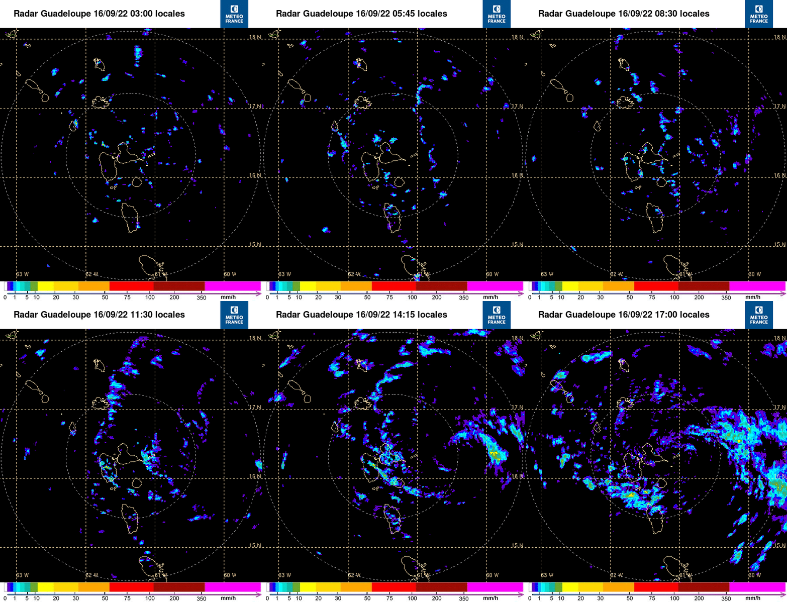
Imagen actual:
Member Since 2005
For official information, please refer to NHC: https://www.nhc.noaa.gov
Hurricane’s hit Puerto Rico:
San Felipe 1928, San Ciprián 1932, Santa Clara 1956, Hugo 1989, Marilyn 1995, Hortense 1996, Georges 1998, Maria 2017, Fiona 2022
Model Runs:
GFS:
[5:30 AM/PM, 11:30 AM/PM]
HWRF, GFDL, UKMET, NAVGEM:
[6:30-8:00 AM/PM, 12:30-2:00 AM/PM]
ECMWF:
[1:45 AM/PM]
Re: Tormenta Tropical Fiona al este de las Antillas
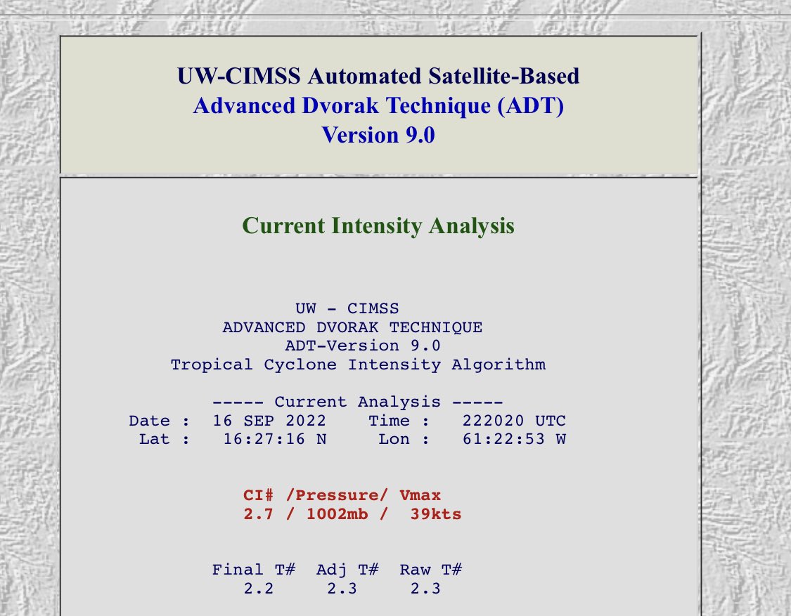
Parece que está pasándola mal. ADT ha bajado los final T numbers de 2.7 a 2.2.
Re: Tormenta Tropical Fiona al este de las Antillas
FIONA NO TE ENTIENDO JAJAJAJA
-
StormWatch
- Cat. 3

- Posts: 3755
- Joined: Thu Aug 06, 2015 11:39 am
- Location: Texas, USA
Re: Tormenta Tropical Fiona al este de las Antillas
En rojo es la conclusión verdad?
Member Since 2005
For official information, please refer to NHC: https://www.nhc.noaa.gov
Hurricane’s hit Puerto Rico:
San Felipe 1928, San Ciprián 1932, Santa Clara 1956, Hugo 1989, Marilyn 1995, Hortense 1996, Georges 1998, Maria 2017, Fiona 2022
Model Runs:
GFS:
[5:30 AM/PM, 11:30 AM/PM]
HWRF, GFDL, UKMET, NAVGEM:
[6:30-8:00 AM/PM, 12:30-2:00 AM/PM]
ECMWF:
[1:45 AM/PM]
For official information, please refer to NHC: https://www.nhc.noaa.gov
Hurricane’s hit Puerto Rico:
San Felipe 1928, San Ciprián 1932, Santa Clara 1956, Hugo 1989, Marilyn 1995, Hortense 1996, Georges 1998, Maria 2017, Fiona 2022
Model Runs:
GFS:
[5:30 AM/PM, 11:30 AM/PM]
HWRF, GFDL, UKMET, NAVGEM:
[6:30-8:00 AM/PM, 12:30-2:00 AM/PM]
ECMWF:
[1:45 AM/PM]
Re: Tormenta Tropical Fiona al este de las Antillas
The “Raw T#” value is the unadjusted Raw “DT” number determined using the
current scene type and measured environmental parameters (Section 5B and 5C) for the
selected scene type (cloud curvature, eye/cloud temperatures, etc.). The “Adj T#” value
represents the current intensity of the storm after any Constraint Limit (Dvorak “Rule 8”)
rules have been applied (see Section 5F). The “Final T#” value is the average of the
current and previous three hour analyses values (see Section 5D). Finally, the “CI#” value
represents the 3-hour averaged value after various ADT rules and constraints governing
its variability, listed next to the Constraint Limits and Weakening Flag labels at the end of
18
the intensity bulletin, have been applied. For more details on these rules, see Sections 5E,
5F, and 5G.
The EIR Rule 9 will hold the CI# at values 0.5 to 1.0 higher in value than the current Final T# (Raw T#
after adjustments and time-averaging). Subjective application of this rule (e.g. how and
when to apply it) varies between forecasters and is the focal point of much debate
https://tropic.ssec.wisc.edu/misc/adt/g ... _Guide.pdf
-
StormWatch
- Cat. 3

- Posts: 3755
- Joined: Thu Aug 06, 2015 11:39 am
- Location: Texas, USA
Re: Tormenta Tropical Fiona al este de las Antillas
8pm advisory:
NHC forecasts Fiona will strengthen as it enters the Caribbean and approaches Puerto Rico/Hispaniola.
NHC forecasts Fiona will strengthen as it enters the Caribbean and approaches Puerto Rico/Hispaniola.
Member Since 2005
For official information, please refer to NHC: https://www.nhc.noaa.gov
Hurricane’s hit Puerto Rico:
San Felipe 1928, San Ciprián 1932, Santa Clara 1956, Hugo 1989, Marilyn 1995, Hortense 1996, Georges 1998, Maria 2017, Fiona 2022
Model Runs:
GFS:
[5:30 AM/PM, 11:30 AM/PM]
HWRF, GFDL, UKMET, NAVGEM:
[6:30-8:00 AM/PM, 12:30-2:00 AM/PM]
ECMWF:
[1:45 AM/PM]
For official information, please refer to NHC: https://www.nhc.noaa.gov
Hurricane’s hit Puerto Rico:
San Felipe 1928, San Ciprián 1932, Santa Clara 1956, Hugo 1989, Marilyn 1995, Hortense 1996, Georges 1998, Maria 2017, Fiona 2022
Model Runs:
GFS:
[5:30 AM/PM, 11:30 AM/PM]
HWRF, GFDL, UKMET, NAVGEM:
[6:30-8:00 AM/PM, 12:30-2:00 AM/PM]
ECMWF:
[1:45 AM/PM]
Re: Tormenta Tropical Fiona al este de las Antillas
Nos leen.StormWatch wrote: ↑Fri Sep 16, 2022 7:56 pm 8pm advisory:
NHC forecasts Fiona will strengthen as it enters the Caribbean and approaches Puerto Rico/Hispaniola.
Obvio, no lo dicen.
Pero nos leen.
-
StormWatch
- Cat. 3

- Posts: 3755
- Joined: Thu Aug 06, 2015 11:39 am
- Location: Texas, USA
Re: Tormenta Tropical Fiona al este de las Antillas
CycloForum Twitter
Observaciónes de la Isla de Guadalupe indican vientos de tormenta entre 35 y 70 mph. El centro se encuentra justo al nortenoroeste de esa isla. Avión cazahuracán se encuentra volando por la tormenta. #Fiona
LMR
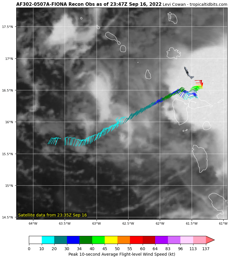
Observaciónes de la Isla de Guadalupe indican vientos de tormenta entre 35 y 70 mph. El centro se encuentra justo al nortenoroeste de esa isla. Avión cazahuracán se encuentra volando por la tormenta. #Fiona
LMR

Member Since 2005
For official information, please refer to NHC: https://www.nhc.noaa.gov
Hurricane’s hit Puerto Rico:
San Felipe 1928, San Ciprián 1932, Santa Clara 1956, Hugo 1989, Marilyn 1995, Hortense 1996, Georges 1998, Maria 2017, Fiona 2022
Model Runs:
GFS:
[5:30 AM/PM, 11:30 AM/PM]
HWRF, GFDL, UKMET, NAVGEM:
[6:30-8:00 AM/PM, 12:30-2:00 AM/PM]
ECMWF:
[1:45 AM/PM]
For official information, please refer to NHC: https://www.nhc.noaa.gov
Hurricane’s hit Puerto Rico:
San Felipe 1928, San Ciprián 1932, Santa Clara 1956, Hugo 1989, Marilyn 1995, Hortense 1996, Georges 1998, Maria 2017, Fiona 2022
Model Runs:
GFS:
[5:30 AM/PM, 11:30 AM/PM]
HWRF, GFDL, UKMET, NAVGEM:
[6:30-8:00 AM/PM, 12:30-2:00 AM/PM]
ECMWF:
[1:45 AM/PM]
-
StormWatch
- Cat. 3

- Posts: 3755
- Joined: Thu Aug 06, 2015 11:39 am
- Location: Texas, USA
Re: Tormenta Tropical Fiona al este de las Antillas
David.79 wrote: ↑Fri Sep 16, 2022 8:03 pmNos leen.StormWatch wrote: ↑Fri Sep 16, 2022 7:56 pm 8pm advisory:
NHC forecasts Fiona will strengthen as it enters the Caribbean and approaches Puerto Rico/Hispaniola.
Obvio, no lo dicen.
Pero nos leen.
Member Since 2005
For official information, please refer to NHC: https://www.nhc.noaa.gov
Hurricane’s hit Puerto Rico:
San Felipe 1928, San Ciprián 1932, Santa Clara 1956, Hugo 1989, Marilyn 1995, Hortense 1996, Georges 1998, Maria 2017, Fiona 2022
Model Runs:
GFS:
[5:30 AM/PM, 11:30 AM/PM]
HWRF, GFDL, UKMET, NAVGEM:
[6:30-8:00 AM/PM, 12:30-2:00 AM/PM]
ECMWF:
[1:45 AM/PM]
For official information, please refer to NHC: https://www.nhc.noaa.gov
Hurricane’s hit Puerto Rico:
San Felipe 1928, San Ciprián 1932, Santa Clara 1956, Hugo 1989, Marilyn 1995, Hortense 1996, Georges 1998, Maria 2017, Fiona 2022
Model Runs:
GFS:
[5:30 AM/PM, 11:30 AM/PM]
HWRF, GFDL, UKMET, NAVGEM:
[6:30-8:00 AM/PM, 12:30-2:00 AM/PM]
ECMWF:
[1:45 AM/PM]


