

Saludos Joe Man, bingo!!! si baja la velocidad de traslación, se intensifica y se convierte en huracán mayor se pudiera acercar peligrosamente siendo también mi preocupación. Seguimos vigilantes.
Huracán Beryl entrando al oeste del Mar Caribe
Re: Huracán Beryl rumbo al Caribe
Suben los vientos a 80mph y parece que continúa su intensificación.
8:00 PM AST Sat Jun 29
Location: 10.2°N 50.3°W
Moving: W at 22 mph
Min pressure: 990 mb
Max sustained: 80 mph
8:00 PM AST Sat Jun 29
Location: 10.2°N 50.3°W
Moving: W at 22 mph
Min pressure: 990 mb
Max sustained: 80 mph

Re: Huracán Beryl rumbo al Caribe
11:00 PM AST Sat Jun 29
Location: 10.4°N 51.2°W
Moving: W at 20 mph
Min pressure: 986 mb
Max sustained: 85 mph
000
WTNT42 KNHC 300243
TCDAT2
Hurricane Beryl Discussion Number 6
NWS National Hurricane Center Miami FL AL022024
1100 PM AST Sat Jun 29 2024
Beryl continues to strengthen rapidly this evening. Cold convective
cloud tops between -70 to -80 C are now wrapping fully around the
center after earlier being confined to its southern semicircle.
After the prior advisory, a late arriving SSMIS microwave pass
revealed a small closed eyewall now exists. The latest subjective
and objective intensity estimates range between 65 to 80 kt and
based on the continued improved structure on satellite imagery, the
intensity is set at 75 kt, towards the upper end of those estimates.
As earlier mentioned, both the NOAA and Air Force Reserve Hurricane
Hunters will investigate Beryl tomorrow morning, which will provide
our first in-situ data to assess the hurricane.
Beryl has maintained a just north of due west fast motion this
evening, estimated at 280/17 kt. An extensive mid-level ridge
remains positioned poleward of the hurricane, and Beryl should
maintain a westward to west-northwestward motion at a similar speed
over the next couple of days. This track will take the hurricane
over the Windward Islands overnight on Sunday into Monday. A subtle
weakness in this ridging in the 24-48 hour period should help the
hurricane gain a bit of latitude before the ridge builds back in
over the southeastern U.S. by the middle of next week, likely
resulting in a turn back more westward by the end of the forecast
period. The NHC forecast track is just a touch left and slower
compared to the prior advisory, but remains very close to a blend of
the consensus aids HCCA and TVCN.
Unfortunately Beryl has all the ingredients favorable for continued
rapid intensification in the short-term. The light to moderate
easterly shear that had been affecting the system is subsiding,
while the hurricane remains embedded in a large area of deep-layer
moisture and over 28-29 C sea-surface temperatures. The small and
well-organized inner core likely means the hurricane should take
full advantage of these pristine conditions, and both the GFS and
ECMWF versions of SHIPS-RII show rapid intensification indices 7 to
10 times above climatology. Thus, the latest NHC intensity forecast
will explicitly show rapid intensification over the next day, making
Beryl a very dangerous Category 3 hurricane before it moves across
the Windward islands by tomorrow night. Once Beryl enters the
Caribbean, there could be a marked increase in westerly vertical
wind shear as a strong easterly low-level jet, common for this time
of year in the eastern Caribbean Sea, will keep Beryl moving quickly
westward against lighter upper-level upper-level easterlies
partially eroded by a deep-layer trough off the Eastern Seaboard.
Thus some weakening is forecast after 48 hours as Beryl moves
further into the Caribbean. The NHC intensity forecast remains close
to the reliable consensus aids and now shows a peak intensity of 110
kt in 36 hours, though a few of the regional-hurricane models do
peak Beryl stronger than shown here.
Key Messages:
1. Beryl is expected to be a dangerous major hurricane when it
reaches the Windward Islands late Sunday night or Monday, bringing
destructive hurricane-force winds and life-threatening storm surge.
Hurricane Warnings are in effect for much of the Windward Islands.
2. Heavy rainfall and localized flooding is expected across the
Windward Islands Sunday night and Monday.
3. Interests in the central and western Caribbean should monitor the
progress of this system. Users are reminded that there is large
uncertainty at days 4 and 5 and to not focus on the specific details
of the track or intensity forecast.
FORECAST POSITIONS AND MAX WINDS
INIT 30/0300Z 10.4N 51.2W 75 KT 85 MPH
12H 30/1200Z 10.8N 53.7W 90 KT 105 MPH
24H 01/0000Z 11.5N 57.0W 105 KT 120 MPH
36H 01/1200Z 12.3N 60.4W 110 KT 125 MPH
48H 02/0000Z 13.4N 64.0W 110 KT 125 MPH
60H 02/1200Z 14.6N 67.6W 105 KT 120 MPH
72H 03/0000Z 15.6N 71.7W 100 KT 115 MPH
96H 04/0000Z 17.0N 78.9W 85 KT 100 MPH
120H 05/0000Z 18.5N 85.0W 75 KT 85 MPH
$$
Forecaster Papin
Re: Huracán Beryl rumbo al Caribe
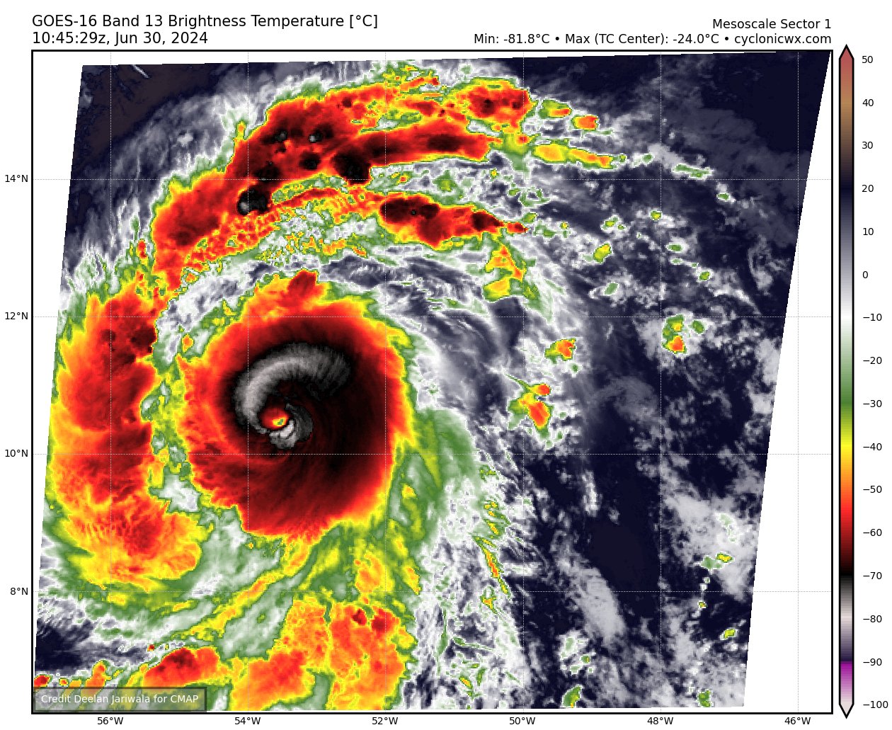
Tratando de sacar un ojo. 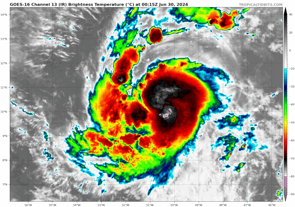
-
StormWatch
- Cat. 3

- Posts: 3755
- Joined: Thu Aug 06, 2015 11:39 am
- Location: Texas, USA
Re: Huracán Beryl rumbo al Caribe
Que clase hermosura! Huracán Beryl
Domingo 30 de Junio, 2024
Para la historia!

Domingo 30 de Junio, 2024
Para la historia!
Member Since 2005
For official information, please refer to NHC: https://www.nhc.noaa.gov
Hurricane’s hit Puerto Rico:
San Felipe 1928, San Ciprián 1932, Santa Clara 1956, Hugo 1989, Marilyn 1995, Hortense 1996, Georges 1998, Maria 2017, Fiona 2022
Model Runs:
GFS:
[5:30 AM/PM, 11:30 AM/PM]
HWRF, GFDL, UKMET, NAVGEM:
[6:30-8:00 AM/PM, 12:30-2:00 AM/PM]
ECMWF:
[1:45 AM/PM]
-
StormWatch
- Cat. 3
- Posts: 3755
- Joined: Thu Aug 06, 2015 11:39 am
- Location: Texas, USA
Re: Huracán Beryl rumbo al Caribe
Que no se ve BRUTAL?
Member Since 2005
For official information, please refer to NHC: https://www.nhc.noaa.gov
Hurricane’s hit Puerto Rico:
San Felipe 1928, San Ciprián 1932, Santa Clara 1956, Hugo 1989, Marilyn 1995, Hortense 1996, Georges 1998, Maria 2017, Fiona 2022
Model Runs:
GFS:
[5:30 AM/PM, 11:30 AM/PM]
HWRF, GFDL, UKMET, NAVGEM:
[6:30-8:00 AM/PM, 12:30-2:00 AM/PM]
ECMWF:
[1:45 AM/PM]
For official information, please refer to NHC: https://www.nhc.noaa.gov
Hurricane’s hit Puerto Rico:
San Felipe 1928, San Ciprián 1932, Santa Clara 1956, Hugo 1989, Marilyn 1995, Hortense 1996, Georges 1998, Maria 2017, Fiona 2022
Model Runs:
GFS:
[5:30 AM/PM, 11:30 AM/PM]
HWRF, GFDL, UKMET, NAVGEM:
[6:30-8:00 AM/PM, 12:30-2:00 AM/PM]
ECMWF:
[1:45 AM/PM]


Re: Huracán Beryl rumbo al Caribe
Lo bueno es que sigue bien rapido su movimiento de traslación lo cual por el momento nos da ese leve respiro de que si se va por el sur seguro. Ahora me preocupa su hermanita que viene detras y que viene algo mas lente comparada con Beryl...
Una observacion...yo no tengo recuerdo que una tormenta se desarrollara con tanta fuerza con lo rapido que se esta moviendo. Usualmente dan un frenazo para fortalecer mas...pero esta...para mi esta algo fuera de lo normal su fortalecimiento.
Si alguien tiene un ejemplo similar a este que haya ocurrido antes, por favor dejemelo saber para refrescar mi memoria
Disclaimer: "Solo soy otro fan de la meteorolgia...para informacion mas precisa vaya a buscarla del NHC y del SNM.... No soy la voz oficial de comunicaciones de la AAA asi que pendiente a sus anuncios oficiales en los medios de comunicación de prensa escrita, radial, televisiva, redes socials, etc."
-
StormWatch
- Cat. 3
- Posts: 3755
- Joined: Thu Aug 06, 2015 11:39 am
- Location: Texas, USA
Re: Huracán Beryl rumbo al Caribe
.
Last edited by StormWatch on Sun Jun 30, 2024 12:36 pm, edited 2 times in total.
Member Since 2005
For official information, please refer to NHC: https://www.nhc.noaa.gov
Hurricane’s hit Puerto Rico:
San Felipe 1928, San Ciprián 1932, Santa Clara 1956, Hugo 1989, Marilyn 1995, Hortense 1996, Georges 1998, Maria 2017, Fiona 2022
Model Runs:
GFS:
[5:30 AM/PM, 11:30 AM/PM]
HWRF, GFDL, UKMET, NAVGEM:
[6:30-8:00 AM/PM, 12:30-2:00 AM/PM]
ECMWF:
[1:45 AM/PM]
For official information, please refer to NHC: https://www.nhc.noaa.gov
Hurricane’s hit Puerto Rico:
San Felipe 1928, San Ciprián 1932, Santa Clara 1956, Hugo 1989, Marilyn 1995, Hortense 1996, Georges 1998, Maria 2017, Fiona 2022
Model Runs:
GFS:
[5:30 AM/PM, 11:30 AM/PM]
HWRF, GFDL, UKMET, NAVGEM:
[6:30-8:00 AM/PM, 12:30-2:00 AM/PM]
ECMWF:
[1:45 AM/PM]