

Huracán Beryl entrando al oeste del Mar Caribe
-
StormWatch
- Cat. 3

- Posts: 3755
- Joined: Thu Aug 06, 2015 11:39 am
- Location: Texas, USA
Re: Tormenta Tropical Beryl rumbo al Caribe
Tormenta Tropical Beryl
Member Since 2005
For official information, please refer to NHC: https://www.nhc.noaa.gov
Hurricane’s hit Puerto Rico:
San Felipe 1928, San Ciprián 1932, Santa Clara 1956, Hugo 1989, Marilyn 1995, Hortense 1996, Georges 1998, Maria 2017, Fiona 2022
Model Runs:
GFS:
[5:30 AM/PM, 11:30 AM/PM]
HWRF, GFDL, UKMET, NAVGEM:
[6:30-8:00 AM/PM, 12:30-2:00 AM/PM]
ECMWF:
[1:45 AM/PM]
-
StormWatch
- Cat. 3
- Posts: 3755
- Joined: Thu Aug 06, 2015 11:39 am
- Location: Texas, USA
Re: Tormenta Tropical Beryl rumbo al Caribe
La Naturaleza en todo su esplendor!
Member Since 2005
For official information, please refer to NHC: https://www.nhc.noaa.gov
Hurricane’s hit Puerto Rico:
San Felipe 1928, San Ciprián 1932, Santa Clara 1956, Hugo 1989, Marilyn 1995, Hortense 1996, Georges 1998, Maria 2017, Fiona 2022
Model Runs:
GFS:
[5:30 AM/PM, 11:30 AM/PM]
HWRF, GFDL, UKMET, NAVGEM:
[6:30-8:00 AM/PM, 12:30-2:00 AM/PM]
ECMWF:
[1:45 AM/PM]
For official information, please refer to NHC: https://www.nhc.noaa.gov
Hurricane’s hit Puerto Rico:
San Felipe 1928, San Ciprián 1932, Santa Clara 1956, Hugo 1989, Marilyn 1995, Hortense 1996, Georges 1998, Maria 2017, Fiona 2022
Model Runs:
GFS:
[5:30 AM/PM, 11:30 AM/PM]
HWRF, GFDL, UKMET, NAVGEM:
[6:30-8:00 AM/PM, 12:30-2:00 AM/PM]
ECMWF:
[1:45 AM/PM]
-
Georges_98
- Invest

- Posts: 230
- Joined: Fri Sep 02, 2016 2:27 am
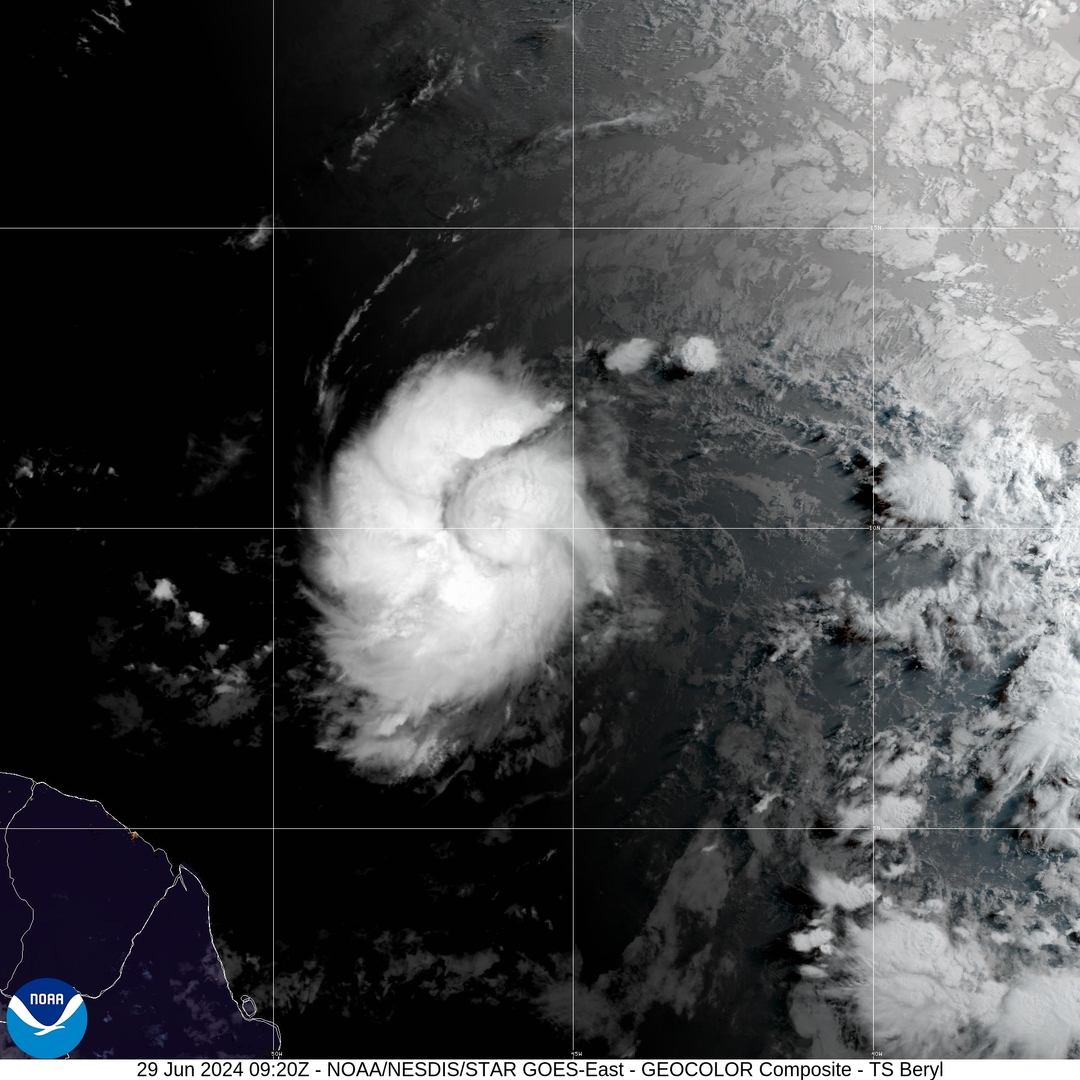
Re: Tormenta Tropical Beryl rumbo al Caribe
Buenos días, Stormwatch y a todos los miembros del foro! Eso correcto, Stormwatch. No dudo que al mediodía de hoy se cambien las alertas a huracán. De hecho, el NHC está previendo un major cuando alcance la latitud sur de P.R. Va a ser increíble ver un segundo sistema convertido en un major en julio. Desde Andrews creo que esto no ocurría.

Re: Tormenta Tropical Beryl rumbo al Caribe
11:00 AM AST Sat Jun 29
Location: 10.0°N 47.8°W
Moving: W at 23 mph
Min pressure: 998 mb
Max sustained: 65 mph
504
WTNT42 KNHC 291447
TCDAT2
Tropical Storm Beryl Discussion Number 4
NWS National Hurricane Center Miami FL AL022024
1100 AM AST Sat Jun 29 2024
Satellite images indicate that Beryl has been strengthening at a
quick pace. The storm is now more symmetric with the low-level
center located beneath an expanding central dense overcast feature.
Showers and thunderstorms are also organized in curved bands on the
west side of the circulation. The initial intensity is increased to
55 kt, in agreement with the Dvorak estimate from TAFB, and Beryl is
nearing hurricane strength.
Beryl has been wobbling around, but the general motion has been
westward at a fast 20 kt. A strong subtropical ridge should keep
the storm moving generally westward at only a slightly slower
forward speed for the next few days. This motion should take Beryl
across the Windward Islands late Sunday night and Monday, and then
across the eastern and central Caribbean Sea early next week. By
the middle of next week, the cyclone might gain a little more
latitude as it feels some influence from a weakness in the ridge,
before another ridge builds to its northwest. The NHC track
forecast has been nudged southward based on the trends in the latest
model runs.
The storm has been on a steady strengthening trend since it formed
yesterday, and now that its structure is more symmetric and compact,
it likely will have an opportunity to rapidly intensify given the
low wind shear conditions. The new NHC intensity forecast
explicitly calls for rapid strengthening and shows Beryl becoming a
major hurricane before moving across the Windward Islands. The
environment becomes a little less conducive after Beryl moves into
the Caribbean Sea, and some increase in shear will likely end its
strengthening phase and cause slow weakening toward the end of the
period. This forecast shows more aggressive strengthening in the
short term and a slightly higher peak intensity than the previous
one, and is near the middle of the guidance envelope.
Key Messages:
1. Beryl is expected to rapidly strengthen and be a major hurricane
when it reaches the Windward Islands late Sunday night or Monday,
bringing destructive hurricane-force winds and life-threatening
storm surge. A Hurricane Watch is in effect for much of the
Windward Islands.
2. Heavy rainfall and localized flooding is expected across the
Windward Islands Sunday night and Monday.
3. Interests in the central and western Caribbean should monitor the
progress of this system. Users are reminded that there is large
uncertainty at days 4 and 5 and to not focus on the specific
details of the track or intensity forecast.
FORECAST POSITIONS AND MAX WINDS
INIT 29/1500Z 10.0N 47.8W 55 KT 65 MPH
12H 30/0000Z 10.4N 50.5W 70 KT 80 MPH
24H 30/1200Z 11.1N 53.8W 85 KT 100 MPH
36H 01/0000Z 11.8N 57.3W 95 KT 110 MPH
48H 01/1200Z 12.6N 60.8W 100 KT 115 MPH
60H 02/0000Z 13.7N 64.3W 100 KT 115 MPH
72H 02/1200Z 14.9N 68.3W 100 KT 115 MPH
96H 03/1200Z 17.0N 75.5W 90 KT 105 MPH
120H 04/1200Z 18.7N 81.4W 80 KT 90 MPH
$$
Forecaster Cangialosi
Re: Tormenta Tropical Beryl rumbo al Caribe
Saludos Georges_98, StormWatch,Boleco,Obi-Wan,David79,Guarican,Caboverde2023,JoeMan y lo demas amigos forista, aqui nada esta escrito en piedra, la ruta oficial al sur de Puerto Rico, República Dominicana, pero una velocidad más lenta de traslación,Georges_98 wrote: ↑Sat Jun 29, 2024 5:51 am Buenos días, Stormwatch y a todos los miembros del foro! Eso correcto, Stormwatch. No dudo que al mediodía de hoy se cambien las alertas a huracán. De hecho, el NHC está previendo un major cuando alcance la latitud sur de P.R. Va a ser increíble ver un segundo sistema convertido en un major en julio. Desde Andrews creo que esto no ocurría.
un fortalecimiento mayor a lo estimado, una vaguada que profundice y tenga algún efecto de atraer un ciclón por completo o por un periodo de tiempo corto, una alta presión fuerte o que se debilite entre otros factores pueden cambiar la historia, así que siempre pendientes y ojo de águila en todo momento. Un abrazos a todos y nos quedan días de observación y monitoreo extremo.


Re: Tormenta Tropical Beryl rumbo al Caribe
Esa es la parte que me preocupa...que baje la velocidad....
Disclaimer: "Solo soy otro fan de la meteorolgia...para informacion mas precisa vaya a buscarla del NHC y del SNM.... No soy la voz oficial de comunicaciones de la AAA asi que pendiente a sus anuncios oficiales en los medios de comunicación de prensa escrita, radial, televisiva, redes socials, etc."
-
Caboverde2023
- Onda Tropical

- Posts: 14
- Joined: Fri Jun 16, 2023 6:43 pm
Re: Tormenta Tropical Beryl rumbo al Caribe
Esa imagen se ve preocupante
Re: Huracán Beryl rumbo al Caribe
000
WTNT42 KNHC 292036
TCDAT2
Hurricane Beryl Discussion Number 5
NWS National Hurricane Center Miami FL AL022024
500 PM AST Sat Jun 29 2024
Beryl continues to rapidly strengthen, and has now become a
hurricane. Satellite images show an expanding central dense
overcast feature, and recent microwave images indicate that a
partial eyewall has formed. This intensity estimate is in agreement
with the Dvorak estimate from TAFB of T4.0/65 kt. Beryl is a
compact tropical cyclone, with its tropical-storm-force winds
estimated to extend up to 50 n mi from the center. Both the NOAA
and Air Force Reserve Hurricane Hunters are scheduled to investigate
Beryl tomorrow, and the data they collect will be very helpful in
assessing the system's structure and intensity.
Beryl continues to wobble around, but the general motion has been
westward at a quick 19 kt. A strong subtropical ridge should keep
the hurricane moving generally westward at only a slightly slower
forward speed for the next couple of days. This motion should take
Beryl across the Windward Islands late Sunday night and Monday. A
weakness in the ridge could cause Beryl to gain a little more
latitude during the early and middle portions of next week, before
turning back slightly to the left as another ridge builds to the
northwest of Beryl. The NHC track forecast is very similar to the
previous one and in fairly good agreement with the various consensus
models.
Now that Beryl has developed a compact inner core, it seems likely
that it will continue to intensify quickly since the hurricane will
remain in near ideal environmental conditions during the next day or
two. The NHC intensity forecast is again nudged upward in the short
term, and shows Beryl becoming a dangerous major hurricane prior to
it reaching the Windward Islands. Beyond a couple of days, when
Beryl is moving across the Caribbean, an increase in shear should
end the strengthening trend and induce some weakening toward the end
of the forecast period. The intensity models are coming into better
agreement on this scenario, and the NHC forecast is roughly near
the middle of the guidance envelope.
Key Messages:
1. Beryl is expected to be a dangerous major hurricane when it
reaches the Windward Islands late Sunday night or Monday,
bringing destructive hurricane-force winds and life-threatening
storm surge. Hurricane Watch and Warnings are in effect for much
of the Windward Islands.
2. Heavy rainfall and localized flooding is expected across the
Windward Islands Sunday night and Monday.
3. Interests in the central and western Caribbean should monitor the
progress of this system. Users are reminded that there is large
uncertainty at days 4 and 5 and to not focus on the specific
details of the track or intensity forecast.
FORECAST POSITIONS AND MAX WINDS
INIT 29/2100Z 10.1N 49.3W 65 KT 75 MPH
12H 30/0600Z 10.6N 51.9W 75 KT 85 MPH
24H 30/1800Z 11.3N 55.3W 90 KT 105 MPH
36H 01/0600Z 12.0N 58.7W 100 KT 115 MPH
48H 01/1800Z 13.1N 62.3W 105 KT 120 MPH
60H 02/0600Z 14.3N 66.0W 105 KT 120 MPH
72H 02/1800Z 15.5N 69.8W 100 KT 115 MPH
96H 03/1800Z 17.3N 77.2W 90 KT 105 MPH
120H 04/1800Z 18.7N 83.3W 75 KT 85 MPH
$$
Forecaster Cangialosi