

Amig@s, oficialmente tenemos a la DT#13, a las 11pm comienzan los avisos por parte del NHC.
Cómo creen que será ese primer cono de trayectoria?
Yo diría tocando el noreste de PR o muy cerca.
Saludos!
Huracan Laura

-
huracan sur
- Depresión Tropical

- Posts: 400
- Joined: Wed Sep 04, 2013 3:26 am
Re: Depresión Tropical 13
Del saque con los cambios de las últimas corridas, creo la trayectoria será tocando algunas islitas las más al NE. Y como a 50-100 millas al norte como tormenta moderada 60mph.
Para información oficial favor referirse a las agencias pertinentes. Un aficionado a la meteorología #TeamCycloforums
Re: Depresión Tropical 13
Saludos si se dejan llevar por el Europeo y GFS cerca al norte. Veremos
-
StormWatch
- Cat. 3

- Posts: 3755
- Joined: Thu Aug 06, 2015 11:39 am
- Location: Texas, USA
Re: Depresión Tropical 13
Entrando por Fajardo...Anótalo
Member Since 2005
For official information, please refer to NHC: https://www.nhc.noaa.gov
Hurricane’s hit Puerto Rico:
San Felipe 1928, San Ciprián 1932, Santa Clara 1956, Hugo 1989, Marilyn 1995, Hortense 1996, Georges 1998, Maria 2017, Fiona 2022
Model Runs:
GFS:
[5:30 AM/PM, 11:30 AM/PM]
HWRF, GFDL, UKMET, NAVGEM:
[6:30-8:00 AM/PM, 12:30-2:00 AM/PM]
ECMWF:
[1:45 AM/PM]
-
StormWatch
- Cat. 3
- Posts: 3755
- Joined: Thu Aug 06, 2015 11:39 am
- Location: Texas, USA
Re: Depresión Tropical 13
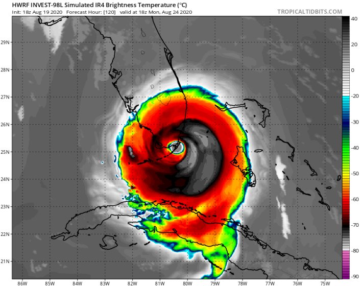
FLORIDA WE HAVE A PROBLEM! 
Member Since 2005
For official information, please refer to NHC: https://www.nhc.noaa.gov
Hurricane’s hit Puerto Rico:
San Felipe 1928, San Ciprián 1932, Santa Clara 1956, Hugo 1989, Marilyn 1995, Hortense 1996, Georges 1998, Maria 2017, Fiona 2022
Model Runs:
GFS:
[5:30 AM/PM, 11:30 AM/PM]
HWRF, GFDL, UKMET, NAVGEM:
[6:30-8:00 AM/PM, 12:30-2:00 AM/PM]
ECMWF:
[1:45 AM/PM]
For official information, please refer to NHC: https://www.nhc.noaa.gov
Hurricane’s hit Puerto Rico:
San Felipe 1928, San Ciprián 1932, Santa Clara 1956, Hugo 1989, Marilyn 1995, Hortense 1996, Georges 1998, Maria 2017, Fiona 2022
Model Runs:
GFS:
[5:30 AM/PM, 11:30 AM/PM]
HWRF, GFDL, UKMET, NAVGEM:
[6:30-8:00 AM/PM, 12:30-2:00 AM/PM]
ECMWF:
[1:45 AM/PM]

Re: Depresión Tropical 13
Parecida la ruta de Federico del 1979?
Disclaimer: "Solo soy otro fan de la meteorolgia...para informacion mas precisa vaya a buscarla del NHC y del SNM.... No soy la voz oficial de comunicaciones de la AAA asi que pendiente a sus anuncios oficiales en los medios de comunicación de prensa escrita, radial, televisiva, redes socials, etc."
-
StormWatch
- Cat. 3
- Posts: 3755
- Joined: Thu Aug 06, 2015 11:39 am
- Location: Texas, USA
Re: Depresión Tropical 13
TROPICAL DEPRESSION THIRTEEN FORECAST/ADVISORY NUMBER 1
NWS NATIONAL HURRICANE CENTER MIAMI FL AL132020
0300 UTC THU AUG 20 2020
CHANGES IN WATCHES AND WARNINGS WITH THIS ADVISORY...
THE GOVERNMENT OF THE NETHERLANDS HAS ISSUED A TROPICAL STORM
WATCH FOR SABA AND ST. EUSTATIUS.
SUMMARY OF WATCHES AND WARNINGS IN EFFECT...
A TROPICAL STORM WATCH IS IN EFFECT FOR...
* SABA AND ST. EUSTATIUS
A TROPICAL STORM WATCH MEANS THAT TROPICAL STORM CONDITIONS ARE
POSSIBLE WITHIN THE WATCH AREA...GENERALLY WITHIN 48 HOURS.
INTERESTS ELSEWHERE IN THE NORTHERN LEEWARD ISLANDS...THE VIRGIN
ISLANDS...AND PUERTO RICO SHOULD MONITOR THE PROGRESS OF THIS
SYSTEM...AS TROPICAL STORM WATCHES COULD BE REQUIRED FOR THOSE
AREAS ON THURSDAY.
TROPICAL DEPRESSION CENTER LOCATED NEAR 14.6N 47.9W AT 20/0300Z
POSITION ACCURATE WITHIN 45 NM
PRESENT MOVEMENT TOWARD THE WEST-NORTHWEST OR 295 DEGREES AT 17 KT
ESTIMATED MINIMUM CENTRAL PRESSURE 1008 MB
MAX SUSTAINED WINDS 30 KT WITH GUSTS TO 40 KT.
WINDS AND SEAS VARY GREATLY IN EACH QUADRANT. RADII IN NAUTICAL
MILES ARE THE LARGEST RADII EXPECTED ANYWHERE IN THAT QUADRANT.
REPEAT...CENTER LOCATED NEAR 14.6N 47.9W AT 20/0300Z
AT 20/0000Z CENTER WAS LOCATED NEAR 14.4N 47.3W
FORECAST VALID 20/1200Z 16.1N 50.8W
MAX WIND 30 KT...GUSTS 40 KT.
FORECAST VALID 21/0000Z 17.4N 54.6W
MAX WIND 35 KT...GUSTS 45 KT.
34 KT... 40NE 40SE 0SW 30NW.
FORECAST VALID 21/1200Z 18.4N 58.4W
MAX WIND 40 KT...GUSTS 50 KT.
34 KT... 70NE 60SE 0SW 50NW.
FORECAST VALID 22/0000Z 19.1N 62.1W
MAX WIND 45 KT...GUSTS 55 KT.
34 KT... 90NE 80SE 0SW 70NW.
FORECAST VALID 22/1200Z 19.9N 65.9W
MAX WIND 50 KT...GUSTS 60 KT.
50 KT... 40NE 0SE 0SW 40NW.
34 KT...110NE 90SE 30SW 90NW.
FORECAST VALID 23/0000Z 20.8N 69.7W
MAX WIND 55 KT...GUSTS 65 KT.
50 KT... 40NE 0SE 0SW 40NW.
34 KT...110NE 90SE 30SW 90NW.
EXTENDED OUTLOOK. NOTE...ERRORS FOR TRACK HAVE AVERAGED NEAR 150 NM
ON DAY 4 AND 175 NM ON DAY 5...AND FOR INTENSITY NEAR 15 KT EACH DAY
OUTLOOK VALID 24/0000Z 22.9N 76.7W
MAX WIND 60 KT...GUSTS 75 KT.
OUTLOOK VALID 25/0000Z 26.2N 82.2W
MAX WIND 60 KT...GUSTS 75 KT.
REQUEST FOR 3 HOURLY SHIP REPORTS WITHIN 300 MILES OF 14.6N 47.9W
INTERMEDIATE PUBLIC ADVISORY...WTNT33 KNHC/MIATCPAT3...AT 20/0600Z
NEXT ADVISORY AT 20/0900Z
$$
FORECASTER CANGIALOSI
Member Since 2005
For official information, please refer to NHC: https://www.nhc.noaa.gov
Hurricane’s hit Puerto Rico:
San Felipe 1928, San Ciprián 1932, Santa Clara 1956, Hugo 1989, Marilyn 1995, Hortense 1996, Georges 1998, Maria 2017, Fiona 2022
Model Runs:
GFS:
[5:30 AM/PM, 11:30 AM/PM]
HWRF, GFDL, UKMET, NAVGEM:
[6:30-8:00 AM/PM, 12:30-2:00 AM/PM]
ECMWF:
[1:45 AM/PM]
For official information, please refer to NHC: https://www.nhc.noaa.gov
Hurricane’s hit Puerto Rico:
San Felipe 1928, San Ciprián 1932, Santa Clara 1956, Hugo 1989, Marilyn 1995, Hortense 1996, Georges 1998, Maria 2017, Fiona 2022
Model Runs:
GFS:
[5:30 AM/PM, 11:30 AM/PM]
HWRF, GFDL, UKMET, NAVGEM:
[6:30-8:00 AM/PM, 12:30-2:00 AM/PM]
ECMWF:
[1:45 AM/PM]
-
StormWatch
- Cat. 3
- Posts: 3755
- Joined: Thu Aug 06, 2015 11:39 am
- Location: Texas, USA
Re: Depresión Tropical 13
Aqui va!

Member Since 2005
For official information, please refer to NHC: https://www.nhc.noaa.gov
Hurricane’s hit Puerto Rico:
San Felipe 1928, San Ciprián 1932, Santa Clara 1956, Hugo 1989, Marilyn 1995, Hortense 1996, Georges 1998, Maria 2017, Fiona 2022
Model Runs:
GFS:
[5:30 AM/PM, 11:30 AM/PM]
HWRF, GFDL, UKMET, NAVGEM:
[6:30-8:00 AM/PM, 12:30-2:00 AM/PM]
ECMWF:
[1:45 AM/PM]
For official information, please refer to NHC: https://www.nhc.noaa.gov
Hurricane’s hit Puerto Rico:
San Felipe 1928, San Ciprián 1932, Santa Clara 1956, Hugo 1989, Marilyn 1995, Hortense 1996, Georges 1998, Maria 2017, Fiona 2022
Model Runs:
GFS:
[5:30 AM/PM, 11:30 AM/PM]
HWRF, GFDL, UKMET, NAVGEM:
[6:30-8:00 AM/PM, 12:30-2:00 AM/PM]
ECMWF:
[1:45 AM/PM]
Re: Depresión Tropical 13
Key Messages:
1. Tropical storm conditions are possible across portions of the
northern Leeward Islands by Friday night, and Tropical Storm Watches
have been issued for some of these islands. Heavy rainfall is
likely across this area beginning late Friday.
2. There is a risk of tropical storm conditions in the Virgin
Islands and Puerto Rico Friday night and Saturday and Tropical
Storm Watches could be required for these islands tomorrow.
Interests there should closely monitor the progress of this system.
3. The details of the long-range track and intensity forecasts are
more uncertain than usual since the system could move over portions
of the Greater Antilles this weekend. However, this system could
bring some rainfall and wind impacts to portions of Hispaniola,
Cuba, the Bahamas, and Florida this weekend and early next week.
Interests there should monitor this system's progress and updates to
the forecast over the next few days.