


Tormenta Isaac

Re: Tormenta Tropical Isaac
Increiblemente pero ayer y hoy el ASCAT ha podido tomar buenas imagenes de vientos de Isaac


Re: Tormenta Tropical Isaac
Viendo la imagen del visible que puso un forista veo amplia humedad alrededor de Isaac. Es muy amplio típico de los sistemas Cabo Verde. Creo que la ruta no la despinta nadie. Ahora lo que nos interesa es la intensidad. La intensidad decidirá que tan cerca pueda pasar el sistema. Ahora se menciona en la discussion una vaguada que podría afectar trayectoria. Un huracán intenso no va a mantenerse en una linea recta al oeste es natural cierta recurvatura.El HWRF lleva varias corridas con un huracán súper intenso. Como mencionaron algunos compañeros pronosticó intensidad de María y me acuerdo cómo estábamos incrédulos hasta que María exploto. Pueden leer el hilo de María y verán 930mb pronosticó. Recordemos la fecha en que estamos. El pico del pico.
-
StormWatch
- Cat. 3

- Posts: 3755
- Joined: Thu Aug 06, 2015 11:39 am
- Location: Texas, USA
Re: Tormenta Tropical Isaac
Comió espinacas?

Member Since 2005
For official information, please refer to NHC: https://www.nhc.noaa.gov
Hurricane’s hit Puerto Rico:
San Felipe 1928, San Ciprián 1932, Santa Clara 1956, Hugo 1989, Marilyn 1995, Hortense 1996, Georges 1998, Maria 2017, Fiona 2022
Model Runs:
GFS:
[5:30 AM/PM, 11:30 AM/PM]
HWRF, GFDL, UKMET, NAVGEM:
[6:30-8:00 AM/PM, 12:30-2:00 AM/PM]
ECMWF:
[1:45 AM/PM]

Re: Tormenta Tropical Isaac
Weather Underground
Bob Henson
Isaac will need to traverse the length of the Atlantic tropics before it poses any threat to land. Recurvature is still possible, as indicated consistently by the UKMET and Canadian models, but the bulk of model guidance keeps Isaac heading very steadily westward on a path that would reach the Lesser Antilles around Thursday (as depicted in the NHC forecast). Conditions will favor strengthening over the next several days: wind shear will be low (5 – 10 knots) and SSTs around 27°C (81°F). Later in the week, Isaac will encounter even warmer water (around 28°C) with greater oceanic heat content, but wind shear will also be increasing--perhaps due, in part, to the outflow from Hurricane Florence. The HWRF model, our top performer on intensity in the 2017 season, makes Isaac a solid Category 3 storm by Wednesday: this is considerably above other guidance but is certainly possible.
Re: Tormenta Tropical Isaac
Tropical Storm Isaac Discussion Number 6
NWS National Hurricane Center Miami FL AL092018
1100 PM AST Sat Sep 08 2018
Isaac is strengthening this evening. Satellite images indicate that
the deep convection has been increasing in intensity and coverage
with better defined banding features. The center is not located in
the center of the convection, however, due to some easterly shear.
An ASCAT pass around 00Z showed maximum winds in the 40-45 kt
range. These data are also in line with the latest Dvorak
classifications of 3.0/45 kt from TAFB and SAB. Based on these
estimates, the initial intensity is raised to 45 kt.
Isaac will likely continue to strengthen during the next few days as
the storm remains over warm waters and moves into an environment of
decreasing wind shear. Beyond a few days, the SHIPS model shows a
notable increase in shear, in part due to the outflow from Florence,
which should end the strengthening trend and cause some weakening.
With the exception of the HMON and COAMPS-TC models, the remainder
of the intensity guidance is higher this cycle. The NHC intensity
forecast is raised from the previous one, but it is a little lower
than the HCCA and IVCN guidance.
The storm is moving due westward at 7 kt. The track forecast seems
fairly straightforward. A strengthening subtropical ridge to the
north of the system should cause Isaac to move westward at an
increasing forward speed during the next several days. This
scenario is supported by the usually more reliable GFS and ECMWF
models, and the NHC track forecast is near a blend of those aids.
Based on the current forecast, Isaac will be near the Lesser
Antilles in 4 to 5 days and interests there should monitor the
progress of this system.
FORECAST POSITIONS AND MAX WINDS
INIT 09/0300Z 14.4N 37.5W 45 KT 50 MPH
12H 09/1200Z 14.4N 38.7W 50 KT 60 MPH
24H 10/0000Z 14.5N 40.9W 60 KT 70 MPH
36H 10/1200Z 14.5N 43.5W 70 KT 80 MPH
48H 11/0000Z 14.5N 46.1W 75 KT 85 MPH
72H 12/0000Z 14.5N 51.5W 85 KT 100 MPH
96H 13/0000Z 14.6N 57.0W 80 KT 90 MPH
120H 14/0000Z 15.0N 62.9W 75 KT 85 MPH
$$
Forecaster Cangialosi
-
StormWatch
- Cat. 3
- Posts: 3755
- Joined: Thu Aug 06, 2015 11:39 am
- Location: Texas, USA
Re: Tormenta Tropical Isaac
Via Twitter
The IR/ASCAT overlay feature on @Weathernerds is really nice. #Isaac appears to be aligning the strongest thunderstorms with the low-level center, getting better organized.
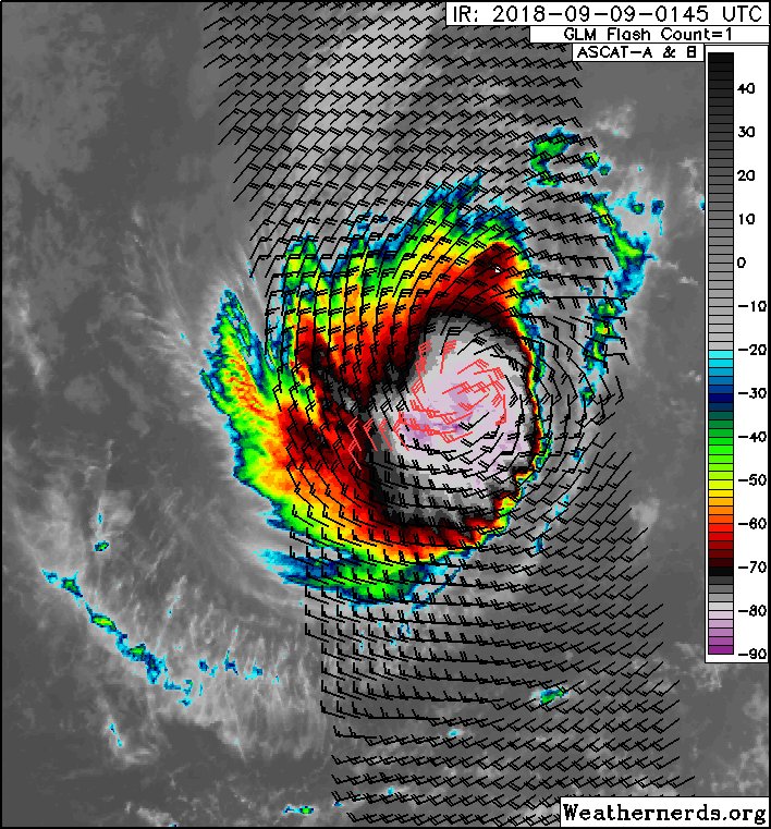
The IR/ASCAT overlay feature on @Weathernerds is really nice. #Isaac appears to be aligning the strongest thunderstorms with the low-level center, getting better organized.
Member Since 2005
For official information, please refer to NHC: https://www.nhc.noaa.gov
Hurricane’s hit Puerto Rico:
San Felipe 1928, San Ciprián 1932, Santa Clara 1956, Hugo 1989, Marilyn 1995, Hortense 1996, Georges 1998, Maria 2017, Fiona 2022
Model Runs:
GFS:
[5:30 AM/PM, 11:30 AM/PM]
HWRF, GFDL, UKMET, NAVGEM:
[6:30-8:00 AM/PM, 12:30-2:00 AM/PM]
ECMWF:
[1:45 AM/PM]
For official information, please refer to NHC: https://www.nhc.noaa.gov
Hurricane’s hit Puerto Rico:
San Felipe 1928, San Ciprián 1932, Santa Clara 1956, Hugo 1989, Marilyn 1995, Hortense 1996, Georges 1998, Maria 2017, Fiona 2022
Model Runs:
GFS:
[5:30 AM/PM, 11:30 AM/PM]
HWRF, GFDL, UKMET, NAVGEM:
[6:30-8:00 AM/PM, 12:30-2:00 AM/PM]
ECMWF:
[1:45 AM/PM]


Re: Tormenta Tropical Isaac
En realidad fue que tomó super vitaminas Pac-Man
Disclaimer: "Solo soy otro fan de la meteorolgia...para informacion mas precisa vaya a buscarla del NHC y del SNM.... No soy la voz oficial de comunicaciones de la AAA asi que pendiente a sus anuncios oficiales en los medios de comunicación de prensa escrita, radial, televisiva, redes socials, etc."