
Huracán Irma

Re: Tormenta Tropical Irma
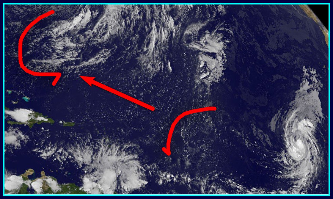
Que clajeeeeee de pelea entre la High y mi prima la Vaguada
Las vaguadas no somos tan malas como algunos creen 
-
StormWatch
- Cat. 3

- Posts: 3755
- Joined: Thu Aug 06, 2015 11:39 am
- Location: Texas, USA
Re: Tormenta Tropical Irma
Yeap! Pero no estará ya para la semana q viene.StormWatch wrote: ↑Wed Aug 30, 2017 7:04 pm Vía Twitter @DaDaBuh
This may be wishful thinking
As of right now based on what I see in the imagery I am going with GFS
THIS COULD CHANGE HOWEVER
Member Since 2005
For official information, please refer to NHC: https://www.nhc.noaa.gov
Hurricane’s hit Puerto Rico:
San Felipe 1928, San Ciprián 1932, Santa Clara 1956, Hugo 1989, Marilyn 1995, Hortense 1996, Georges 1998, Maria 2017, Fiona 2022
Model Runs:
GFS:
[5:30 AM/PM, 11:30 AM/PM]
HWRF, GFDL, UKMET, NAVGEM:
[6:30-8:00 AM/PM, 12:30-2:00 AM/PM]
ECMWF:
[1:45 AM/PM]
-
StormWatch
- Cat. 3
- Posts: 3755
- Joined: Thu Aug 06, 2015 11:39 am
- Location: Texas, USA
Re: Tormenta Tropical Irma
Esa tendencia será real? Un monstruo 

Member Since 2005
For official information, please refer to NHC: https://www.nhc.noaa.gov
Hurricane’s hit Puerto Rico:
San Felipe 1928, San Ciprián 1932, Santa Clara 1956, Hugo 1989, Marilyn 1995, Hortense 1996, Georges 1998, Maria 2017, Fiona 2022
Model Runs:
GFS:
[5:30 AM/PM, 11:30 AM/PM]
HWRF, GFDL, UKMET, NAVGEM:
[6:30-8:00 AM/PM, 12:30-2:00 AM/PM]
ECMWF:
[1:45 AM/PM]
For official information, please refer to NHC: https://www.nhc.noaa.gov
Hurricane’s hit Puerto Rico:
San Felipe 1928, San Ciprián 1932, Santa Clara 1956, Hugo 1989, Marilyn 1995, Hortense 1996, Georges 1998, Maria 2017, Fiona 2022
Model Runs:
GFS:
[5:30 AM/PM, 11:30 AM/PM]
HWRF, GFDL, UKMET, NAVGEM:
[6:30-8:00 AM/PM, 12:30-2:00 AM/PM]
ECMWF:
[1:45 AM/PM]

Re: Tormenta Tropical Irma
De acuerdo contigo horrizonepr, me parece que Irma continua al oeste, veremos por cuanto mas, pero si continua al oeste uyyyy.hurrizonepr wrote: ↑Wed Aug 30, 2017 8:15 pm Parece se movera por debajo del punto proyectado para las 06z. Mas rapido y mas a la izquierda de lo proyectado. Es solo opinion observando la imagen infrarroja
http://www.ssd.noaa.gov/PS/TROP/floater ... short.html
Re: Tormenta Tropical Irma
Irma se ve un poco mas fuerte, subiran los vientos a 65mph o se quedara en 60mph, veremos a las 11pm.
-
StormWatch
- Cat. 3
- Posts: 3755
- Joined: Thu Aug 06, 2015 11:39 am
- Location: Texas, USA
Re: Tormenta Tropical Irma
000
WTNT31 KNHC 310231
TCPAT1
BULLETIN
Tropical Storm Irma Advisory Number 3
NWS National Hurricane Center Miami FL AL112017
1100 PM AST Wed Aug 30 2017
...IRMA EXPECTED TO BECOME A HURRICANE ON THURSDAY...
SUMMARY OF 1100 PM AST...0300 UTC...INFORMATION
-----------------------------------------------
LOCATION...16.4N 32.2W
ABOUT 545 MI...875 KM W OF THE CABO VERDE ISLANDS
MAXIMUM SUSTAINED WINDS...65 MPH...100 KM/H
PRESENT MOVEMENT...W OR 275 DEGREES AT 12 MPH...19 KM/H
MINIMUM CENTRAL PRESSURE...999 MB...29.50 INCHES
WATCHES AND WARNINGS
--------------------
There are no coastal watches or warnings in effect.
DISCUSSION AND 48-HOUR OUTLOOK
------------------------------
At 1100 PM AST (0300 UTC), the center of Tropical Storm Irma was
located near latitude 16.4 North, longitude 32.2 West. Irma is
moving toward the west near 12 mph (19 km/h). A turn toward
the west-northwest is expected by Thursday, and this general motion
should continue through Friday.
Maximum sustained winds have increased to near 65 mph (100 km/h)
with higher gusts. Additional strengthening is forecast and Irma
is expected to become a hurricane on Thursday.
Tropical-storm-force winds extend outward up to 60 miles (95 km)
from the center.
The estimated minimum central pressure is 999 mb (29.50 inches).
HAZARDS AFFECTING LAND
----------------------
None
NEXT ADVISORY
-------------
Next complete advisory at 500 AM AST.
$$
Forecaster Brown
Member Since 2005
For official information, please refer to NHC: https://www.nhc.noaa.gov
Hurricane’s hit Puerto Rico:
San Felipe 1928, San Ciprián 1932, Santa Clara 1956, Hugo 1989, Marilyn 1995, Hortense 1996, Georges 1998, Maria 2017, Fiona 2022
Model Runs:
GFS:
[5:30 AM/PM, 11:30 AM/PM]
HWRF, GFDL, UKMET, NAVGEM:
[6:30-8:00 AM/PM, 12:30-2:00 AM/PM]
ECMWF:
[1:45 AM/PM]
For official information, please refer to NHC: https://www.nhc.noaa.gov
Hurricane’s hit Puerto Rico:
San Felipe 1928, San Ciprián 1932, Santa Clara 1956, Hugo 1989, Marilyn 1995, Hortense 1996, Georges 1998, Maria 2017, Fiona 2022
Model Runs:
GFS:
[5:30 AM/PM, 11:30 AM/PM]
HWRF, GFDL, UKMET, NAVGEM:
[6:30-8:00 AM/PM, 12:30-2:00 AM/PM]
ECMWF:
[1:45 AM/PM]
Re: Tormenta Tropical Irma
Ya salio el boletin de las 11pm
ZCZC MIATCDAT1 ALL
TTAA00 KNHC DDHHMM
Tropical Storm Irma Discussion Number 3
NWS National Hurricane Center Miami FL AL112017
1100 PM AST Wed Aug 30 2017
Irma continues to become better organized, with the development of
a small CDO feature and increased banding near the center. An
earlier high-resolution Windsat microwave overpass showed that Irma
has a tight inner core and a low-level eye-like feature was
present. A Dvorak classification of T3.5 from TAFB is the basis
for the initial intensity of 55 kt. Irma is expected to steadily
strengthen during the next couple of days while it moves through a
low-shear and moist environment, and remains over warm sea
surface temperatures. After that time, slightly cooler SSTs and
lower mid-level moisture may temper the intensification process.
However, the statistical aids, HWRF, and most of the consensus
models make Irma a major hurricane by the end of the forecast
period. The NHC forecast is fairly similar to the previous advisory
through 48 hours, but is above the earlier forecast thereafter. The
new official intensity forecast could still be a little conservative
as it remains a little below the SHIPS/LGEM guidance and the ICON
consensus at days 4 and 5.
Irma is moving westward at about 10 kt to the south of deep-layer
ridge over the eastern Atlantic. The track forecast reasoning is
about the same as the previous advisory, with Irma expected to turn
west-northwestward on Thursday, then continue on that heading
for a couple of days. The high pressure ridge over the central
Atlantic is forecast to strengthen later this week, which is
expected to result in Irma turning west-southwestward by the
weekend. There is still some spread among the track models, so the
NHC forecast lies near a blend of the typically reliable GFS and
ECMWF, and the HFIP corrected consensus.
FORECAST POSITIONS AND MAX WINDS
INIT 31/0300Z 16.4N 32.2W 55 KT 65 MPH
12H 31/1200Z 16.8N 33.6W 65 KT 75 MPH
24H 01/0000Z 17.3N 35.5W 75 KT 85 MPH
36H 01/1200Z 17.7N 37.3W 85 KT 100 MPH
48H 02/0000Z 18.0N 39.5W 90 KT 105 MPH
72H 03/0000Z 17.6N 44.3W 95 KT 110 MPH
96H 04/0000Z 16.8N 49.0W 100 KT 115 MPH
120H 05/0000Z 16.2N 53.5W 105 KT 120 MPH
Re: Tormenta Tropical Irma
Wow!!! 16.2n y 53.5w 120mph 


Re: Tormenta Tropical Irma
Se mantuvo en la 16.4 
-
StormWatch
- Cat. 3
- Posts: 3755
- Joined: Thu Aug 06, 2015 11:39 am
- Location: Texas, USA
Re: Tormenta Tropical Irma
O sea q hubo un ajuste más al OESTE!
Member Since 2005
For official information, please refer to NHC: https://www.nhc.noaa.gov
Hurricane’s hit Puerto Rico:
San Felipe 1928, San Ciprián 1932, Santa Clara 1956, Hugo 1989, Marilyn 1995, Hortense 1996, Georges 1998, Maria 2017, Fiona 2022
Model Runs:
GFS:
[5:30 AM/PM, 11:30 AM/PM]
HWRF, GFDL, UKMET, NAVGEM:
[6:30-8:00 AM/PM, 12:30-2:00 AM/PM]
ECMWF:
[1:45 AM/PM]
For official information, please refer to NHC: https://www.nhc.noaa.gov
Hurricane’s hit Puerto Rico:
San Felipe 1928, San Ciprián 1932, Santa Clara 1956, Hugo 1989, Marilyn 1995, Hortense 1996, Georges 1998, Maria 2017, Fiona 2022
Model Runs:
GFS:
[5:30 AM/PM, 11:30 AM/PM]
HWRF, GFDL, UKMET, NAVGEM:
[6:30-8:00 AM/PM, 12:30-2:00 AM/PM]
ECMWF:
[1:45 AM/PM]