Harvey
Re: INVEST 91L al SE de Cabo Verde: 0%-20%
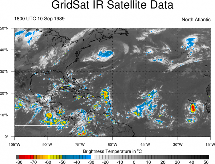
Miren como era Hugo cuando estaba cerca de Cabo Verde
ahora miren esta onda
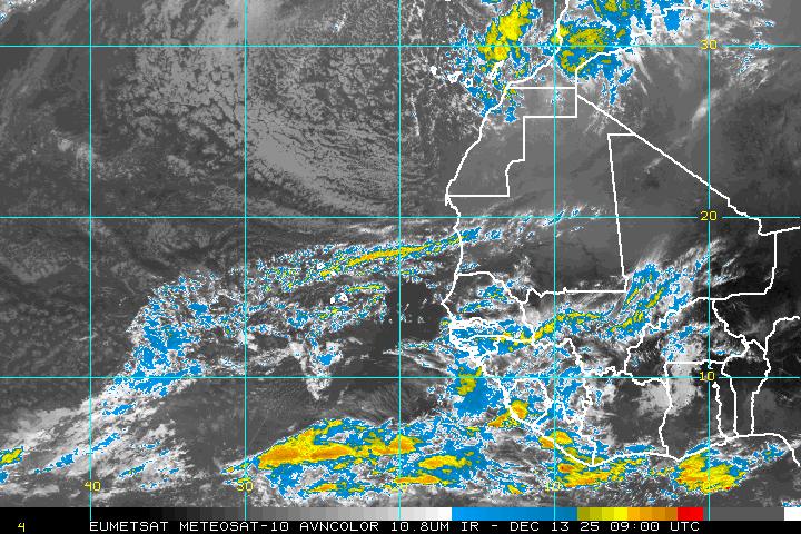
Pueden ver las imagenes de satelite desde los 80s en este link
http://www.atmos.albany.edu/student/ppapin/gridsat.php
ahora miren esta onda
Pueden ver las imagenes de satelite desde los 80s en este link
http://www.atmos.albany.edu/student/ppapin/gridsat.php
Last edited by Arlequín on Sun Aug 13, 2017 10:43 am, edited 1 time in total.
-
- Cat. 3
- Posts: 3755
- Joined: Thu Aug 06, 2015 11:39 am
- Location: Texas, USA
Re: INVEST 91L al SE de Cabo Verde: 0%-20%
Buena comparación, tal vez si su trayectoria pudiera ser due West!Arlequín wrote: ↑Sun Aug 13, 2017 10:26 am Miren como era Hugo cuando estaba cerca de Cabo Verde
ahora miren esta onda
Pueden ver las imagenes de satelite desde los 80s en este link
http://www.atmos.albany.edu/student/ppapin/gridsat.php
Peroooooooo otro Hugo? Fue muy fuerte.
Uffffff sin Energía Eléctrica hasta las Elecciones de Noviembre 2020
Member Since 2005
For official information, please refer to NHC: https://www.nhc.noaa.gov
Hurricane’s hit Puerto Rico:
San Felipe 1928, San Ciprián 1932, Santa Clara 1956, Hugo 1989, Marilyn 1995, Hortense 1996, Georges 1998, Maria 2017, Fiona 2022
Model Runs:
GFS:
[5:30 AM/PM, 11:30 AM/PM]
HWRF, GFDL, UKMET, NAVGEM:
[6:30-8:00 AM/PM, 12:30-2:00 AM/PM]
ECMWF:
[1:45 AM/PM]
-
- Cat. 3
- Posts: 3755
- Joined: Thu Aug 06, 2015 11:39 am
- Location: Texas, USA
Re: INVEST 91L al SE de Cabo Verde: 0%-20%
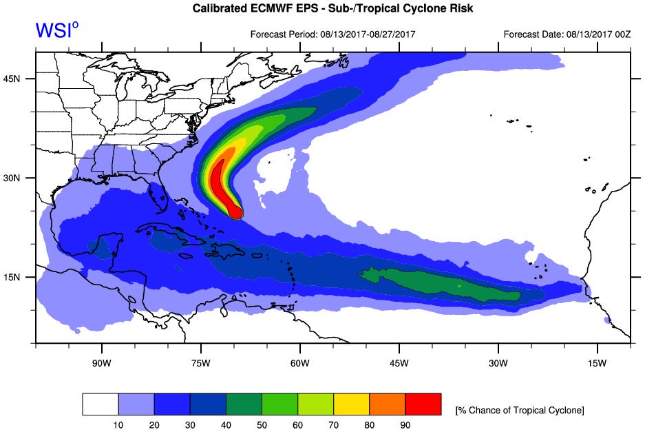
Vía Twitter CycloforumsPR
El pronóstico a LARGO PLAZO del modelo Europeo para el invest 91L indica una posible ruta hacia el Caribe y Golfo de México. @MJVentrice
Member Since 2005
For official information, please refer to NHC: https://www.nhc.noaa.gov
Hurricane’s hit Puerto Rico:
San Felipe 1928, San Ciprián 1932, Santa Clara 1956, Hugo 1989, Marilyn 1995, Hortense 1996, Georges 1998, Maria 2017, Fiona 2022
Model Runs:
GFS:
[5:30 AM/PM, 11:30 AM/PM]
HWRF, GFDL, UKMET, NAVGEM:
[6:30-8:00 AM/PM, 12:30-2:00 AM/PM]
ECMWF:
[1:45 AM/PM]
For official information, please refer to NHC: https://www.nhc.noaa.gov
Hurricane’s hit Puerto Rico:
San Felipe 1928, San Ciprián 1932, Santa Clara 1956, Hugo 1989, Marilyn 1995, Hortense 1996, Georges 1998, Maria 2017, Fiona 2022
Model Runs:
GFS:
[5:30 AM/PM, 11:30 AM/PM]
HWRF, GFDL, UKMET, NAVGEM:
[6:30-8:00 AM/PM, 12:30-2:00 AM/PM]
ECMWF:
[1:45 AM/PM]
Re: INVEST 91L al SE de Cabo Verde: 0%-20%
A mi me gusta un nombre de Harvey para una tormenta acercandose a las Azores con 40mph en vientos maximos...
Re: INVEST 91L al SE de Cabo Verde: 0%-20%
Me gusta esta onda. Tiene un no sé que combinado con un que se yo. De ahí, va a salir algo.
Re: INVEST 91L al SE de Cabo Verde: 0%-20%
Siempre la Madre Naturaleza es la última que ríe.
Re: INVEST 91L al SE de Cabo Verde: 0%-20%
Modelo del Navy 12z:
Siempre la Madre Naturaleza es la última que ríe.
Re: INVEST 91L al SE de Cabo Verde: 0%-20%
Modelo inglés 12z, por el Sur...
... pero de momento tengo dudas si desarrolla al 91L o al sistema de la 35W. Miren la gráfica del UKMET 00z.
Siempre la Madre Naturaleza es la última que ríe.
Re: INVEST 91L al SE de Cabo Verde: 10%-30%
Sube a 10%-30%.
1. An area of disturbed weather located to the southeast of the Cabo
Verde Islands is associated with a tropical wave. The wave is
forecast to merge with a broad area of low pressure located
southwest of the Cabo Verde Islands in a day or two. Environmental
conditions are expected to become more conducive for development of
this system later this week while it moves westward at about
15 mph over the tropical Atlantic.
* Formation chance through 48 hours...low...near 10 percent.
* Formation chance through 5 days...low...30 percent.