

Esta Onda se ve media sospechosa porque ha mantenido su rotación.. como no le vi tópico, le abro uno, por si acaso..
..TROPICAL WAVES...
A far eastern Atlantic tropical wave extends from 19N26W to
14N27W to 07N27W, moving west at 15 kt. Satellite imagery shows
an exposed cyclonic vortex at 14N27W with no precipitation. This
portion of the wave is embedded in an extensive area of Saharan
dry air and dust. SSMI TPW imagery shows an area of moisture S of
13N. The 700 mb guidance from the GFS model indicates broad
troughing with this wave. Scattered showers are within 120 nm of
the wave axis S of 12N.
Onda Tropical en la longitud 35 - 10-20%
Onda Tropical en la longitud 35 - 10-20%
Last edited by albertopr on Tue Aug 01, 2017 1:54 pm, edited 1 time in total.

Re: Onda Tropical en la longitud 30/35
Buenas noches amigo yo estaba pensando en toda esa humedad quizá salga algo de ahí
Re: Onda Tropical en la longitud 30/35
Saludos Boleco! Se ve interesante porque ha mantenido esa rotación. Me parece que los pasados días los modelos sacaban algo de este sistema, pero dejaron de hacerlo. El HWRF ve algo cerca de las Antillas... pero no estoy seguro de donde lo saca.
-
hurrizonepr
- Depresión Tropical

- Posts: 451
- Joined: Wed Sep 04, 2013 10:30 am
Re: Onda Tropical en la longitud 30/35
Buenos Dias: Esta onda salto a la atencion (del ojo) desde que salio muy fuerte del continente africano. Se ha mantenido bastante bien a pesar del SAL al norte de ella.Incluso ahora mismo sigue luciendo bien. Gracias a Albertopr por abrir el topico, pues se comentaba de ella pero en otro topico :
http://tropic.ssec.wisc.edu/real-time/s ... E5new.html
http://tropic.ssec.wisc.edu/real-time/s ... E5new.html
Re: Onda Tropical en la longitud 35 - 10-20%
Pintura Amarilla
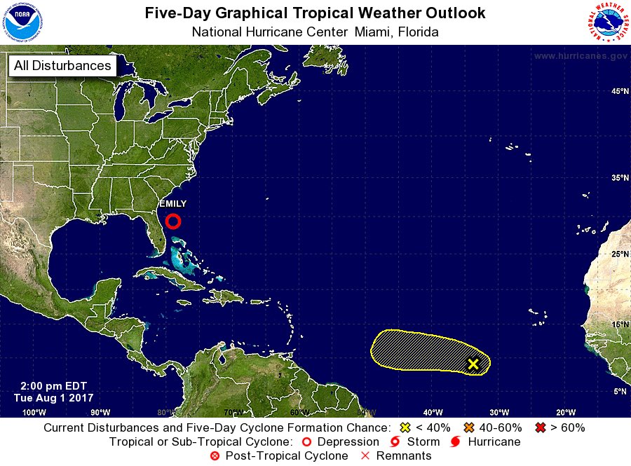
ZCZC MIATWOAT ALL
TTAA00 KNHC DDHHMM
Tropical Weather Outlook
NWS National Hurricane Center Miami FL
200 PM EDT Tue Aug 1 2017
For the North Atlantic...Caribbean Sea and the Gulf of Mexico:
The National Hurricane Center is issuing advisories on Tropical
Depression Emily, located over the Atlantic Ocean well to the east
Florida.
1. A tropical wave accompanied by a low pressure system is producing a
large area of cloudiness and disorganized shower activity several
hundred miles southwest of the Cabo Verde Islands. Some slow
development is possible during the next few days while the
disturbance moves westward at 10 to 15 mph. However, upper-level
winds are expected to become less conducive for development by the
weekend.
* Formation chance through 48 hours...low...10 percent.
* Formation chance through 5 days...low...20 percent.
Forecaster Stewart
-
StormWatch
- Cat. 3

- Posts: 3755
- Joined: Thu Aug 06, 2015 11:39 am
- Location: Texas, USA
Re: Onda Tropical en la longitud 35 - 10-20%
Again! #Tropics @NHC_Atlantic
Member Since 2005
For official information, please refer to NHC: https://www.nhc.noaa.gov
Hurricane’s hit Puerto Rico:
San Felipe 1928, San Ciprián 1932, Santa Clara 1956, Hugo 1989, Marilyn 1995, Hortense 1996, Georges 1998, Maria 2017, Fiona 2022
Model Runs:
GFS:
[5:30 AM/PM, 11:30 AM/PM]
HWRF, GFDL, UKMET, NAVGEM:
[6:30-8:00 AM/PM, 12:30-2:00 AM/PM]
ECMWF:
[1:45 AM/PM]

Re: Onda Tropical en la longitud 35 - 10-20%
Tratando de ser objetivo, no se que modelo predice desarrollo en esta onda
-
ROCKstormSJ4315

- Tormenta Tropical

- Posts: 888
- Joined: Tue Aug 06, 2013 10:09 pm
- Location: Hato Rey, San Juan, PR
Re: Onda Tropical en la longitud 35 - 10-20%
Y parece que seguimos con El mal de la probabilidad estatica. Si esta onda no mejora su aspecto y por tanto en 24 horas no cambian las probabilidades, en mi opinion veremos lo mismo que le paso a sus predecesoras. 
"Georgy Girl", The Seekers
"Back for Good", Take That
"Perfectionist", SAGA
"Graves Into Gardens", Elevation Worship ft. Brandon Lake
"Thunder", Imagine Dragons
"Viva la Vida", Coldplay
"Back for Good", Take That
"Perfectionist", SAGA
"Graves Into Gardens", Elevation Worship ft. Brandon Lake
"Thunder", Imagine Dragons
"Viva la Vida", Coldplay