patio para mantenerlo.. Nunca se sabe lo que pueda pasar el caribe es una caja de pandora..
Detrás de la DT4 (GFS/Europeo agresivos)
Re: Detrás de la DT4 (GFS/Europeo agresivos)
Activado!!! Ya desde hoy limpiando el
patio para mantenerlo.. Nunca se sabe lo que pueda pasar el caribe es una caja de pandora..
patio para mantenerlo.. Nunca se sabe lo que pueda pasar el caribe es una caja de pandora..
-
StormWatch
- Cat. 3

- Posts: 3755
- Joined: Thu Aug 06, 2015 11:39 am
- Location: Texas, USA
Re: Detrás de la DT4 (GFS/Europeo agresivos)
Casi todos al Sur......


Member Since 2005
For official information, please refer to NHC: https://www.nhc.noaa.gov
Hurricane’s hit Puerto Rico:
San Felipe 1928, San Ciprián 1932, Santa Clara 1956, Hugo 1989, Marilyn 1995, Hortense 1996, Georges 1998, Maria 2017, Fiona 2022
Model Runs:
GFS:
[5:30 AM/PM, 11:30 AM/PM]
HWRF, GFDL, UKMET, NAVGEM:
[6:30-8:00 AM/PM, 12:30-2:00 AM/PM]
ECMWF:
[1:45 AM/PM]
-
StormWatch
- Cat. 3

- Posts: 3755
- Joined: Thu Aug 06, 2015 11:39 am
- Location: Texas, USA
Re: Detrás de la DT4 (GFS/Europeo agresivos)
Una Tormenta Tropical en 4 días ....


Member Since 2005
For official information, please refer to NHC: https://www.nhc.noaa.gov
Hurricane’s hit Puerto Rico:
San Felipe 1928, San Ciprián 1932, Santa Clara 1956, Hugo 1989, Marilyn 1995, Hortense 1996, Georges 1998, Maria 2017, Fiona 2022
Model Runs:
GFS:
[5:30 AM/PM, 11:30 AM/PM]
HWRF, GFDL, UKMET, NAVGEM:
[6:30-8:00 AM/PM, 12:30-2:00 AM/PM]
ECMWF:
[1:45 AM/PM]
For official information, please refer to NHC: https://www.nhc.noaa.gov
Hurricane’s hit Puerto Rico:
San Felipe 1928, San Ciprián 1932, Santa Clara 1956, Hugo 1989, Marilyn 1995, Hortense 1996, Georges 1998, Maria 2017, Fiona 2022
Model Runs:
GFS:
[5:30 AM/PM, 11:30 AM/PM]
HWRF, GFDL, UKMET, NAVGEM:
[6:30-8:00 AM/PM, 12:30-2:00 AM/PM]
ECMWF:
[1:45 AM/PM]
-
StormWatch
- Cat. 3

- Posts: 3755
- Joined: Thu Aug 06, 2015 11:39 am
- Location: Texas, USA
Re: Detrás de la DT4 (GFS/Europeo agresivos)
Vía Twitter!
Cerca al sur de PR...........

Cerca al sur de PR...........

Member Since 2005
For official information, please refer to NHC: https://www.nhc.noaa.gov
Hurricane’s hit Puerto Rico:
San Felipe 1928, San Ciprián 1932, Santa Clara 1956, Hugo 1989, Marilyn 1995, Hortense 1996, Georges 1998, Maria 2017, Fiona 2022
Model Runs:
GFS:
[5:30 AM/PM, 11:30 AM/PM]
HWRF, GFDL, UKMET, NAVGEM:
[6:30-8:00 AM/PM, 12:30-2:00 AM/PM]
ECMWF:
[1:45 AM/PM]
For official information, please refer to NHC: https://www.nhc.noaa.gov
Hurricane’s hit Puerto Rico:
San Felipe 1928, San Ciprián 1932, Santa Clara 1956, Hugo 1989, Marilyn 1995, Hortense 1996, Georges 1998, Maria 2017, Fiona 2022
Model Runs:
GFS:
[5:30 AM/PM, 11:30 AM/PM]
HWRF, GFDL, UKMET, NAVGEM:
[6:30-8:00 AM/PM, 12:30-2:00 AM/PM]
ECMWF:
[1:45 AM/PM]
-
StormWatch
- Cat. 3

- Posts: 3755
- Joined: Thu Aug 06, 2015 11:39 am
- Location: Texas, USA
Re: Detrás de la DT4 (GFS/Europeo agresivos)
A las 8pm la mencionan y será Invest!
Member Since 2005
For official information, please refer to NHC: https://www.nhc.noaa.gov
Hurricane’s hit Puerto Rico:
San Felipe 1928, San Ciprián 1932, Santa Clara 1956, Hugo 1989, Marilyn 1995, Hortense 1996, Georges 1998, Maria 2017, Fiona 2022
Model Runs:
GFS:
[5:30 AM/PM, 11:30 AM/PM]
HWRF, GFDL, UKMET, NAVGEM:
[6:30-8:00 AM/PM, 12:30-2:00 AM/PM]
ECMWF:
[1:45 AM/PM]
For official information, please refer to NHC: https://www.nhc.noaa.gov
Hurricane’s hit Puerto Rico:
San Felipe 1928, San Ciprián 1932, Santa Clara 1956, Hugo 1989, Marilyn 1995, Hortense 1996, Georges 1998, Maria 2017, Fiona 2022
Model Runs:
GFS:
[5:30 AM/PM, 11:30 AM/PM]
HWRF, GFDL, UKMET, NAVGEM:
[6:30-8:00 AM/PM, 12:30-2:00 AM/PM]
ECMWF:
[1:45 AM/PM]
Re: Detrás de la DT4 (GFS/Europeo agresivos)
DeberíanStormWatch wrote:A las 8pm la mencionan y será Invest!
-
hurrizonepr
- Depresión Tropical

- Posts: 451
- Joined: Wed Sep 04, 2013 10:30 am
Re: Detrás de la DT4 (GFS/Europeo agresivos)
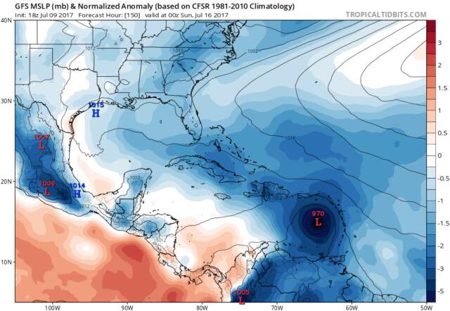
El 18z vuelve a desarrollar y la pasa mas cerca al Sur de nuestra area:
http://www.tropicaltidbits.com/analysis ... 0&ypos=375
El nuevo GFS-P no ve desarrollo significativo y pasa la baja presion cercano a la costa de Suramerica:
http://www.tropicaltidbits.com/analysis ... 0&ypos=240
http://www.tropicaltidbits.com/analysis ... 0&ypos=375
El nuevo GFS-P no ve desarrollo significativo y pasa la baja presion cercano a la costa de Suramerica:
http://www.tropicaltidbits.com/analysis ... 0&ypos=240
-
huracan_1975
- Tormenta Tropical

- Posts: 630
- Joined: Sun Aug 16, 2015 9:59 am
Re: Detrás de la DT4 (GFS/Europeo agresivos)
000
ABNT20 KNHC 092336
TWOAT
Tropical Weather Outlook
NWS National Hurricane Center Miami FL
800 PM EDT Sun Jul 9 2017
For the North Atlantic...Caribbean Sea and the Gulf of Mexico:
A tropical wave passing south of the Cabo Verde Islands is
producing disorganized showers and thunderstorms. Some gradual
development of this system is possible during the next several
days while it moves westward at 15 to 20 mph.
* Formation chance through 48 hours...low...near 0 percent.
* Formation chance through 5 days...low...20 percent.
$$
Forecaster Brown
-
StormWatch
- Cat. 3

- Posts: 3755
- Joined: Thu Aug 06, 2015 11:39 am
- Location: Texas, USA
Re: Detrás de la DT4 (GFS/Europeo agresivos)
Vamos arribaaaaaaaa!


Member Since 2005
For official information, please refer to NHC: https://www.nhc.noaa.gov
Hurricane’s hit Puerto Rico:
San Felipe 1928, San Ciprián 1932, Santa Clara 1956, Hugo 1989, Marilyn 1995, Hortense 1996, Georges 1998, Maria 2017, Fiona 2022
Model Runs:
GFS:
[5:30 AM/PM, 11:30 AM/PM]
HWRF, GFDL, UKMET, NAVGEM:
[6:30-8:00 AM/PM, 12:30-2:00 AM/PM]
ECMWF:
[1:45 AM/PM]
For official information, please refer to NHC: https://www.nhc.noaa.gov
Hurricane’s hit Puerto Rico:
San Felipe 1928, San Ciprián 1932, Santa Clara 1956, Hugo 1989, Marilyn 1995, Hortense 1996, Georges 1998, Maria 2017, Fiona 2022
Model Runs:
GFS:
[5:30 AM/PM, 11:30 AM/PM]
HWRF, GFDL, UKMET, NAVGEM:
[6:30-8:00 AM/PM, 12:30-2:00 AM/PM]
ECMWF:
[1:45 AM/PM]
-
StormWatch
- Cat. 3

- Posts: 3755
- Joined: Thu Aug 06, 2015 11:39 am
- Location: Texas, USA
Re: Detrás de la DT4 (GFS/Europeo agresivos)

Member Since 2005
For official information, please refer to NHC: https://www.nhc.noaa.gov
Hurricane’s hit Puerto Rico:
San Felipe 1928, San Ciprián 1932, Santa Clara 1956, Hugo 1989, Marilyn 1995, Hortense 1996, Georges 1998, Maria 2017, Fiona 2022
Model Runs:
GFS:
[5:30 AM/PM, 11:30 AM/PM]
HWRF, GFDL, UKMET, NAVGEM:
[6:30-8:00 AM/PM, 12:30-2:00 AM/PM]
ECMWF:
[1:45 AM/PM]
For official information, please refer to NHC: https://www.nhc.noaa.gov
Hurricane’s hit Puerto Rico:
San Felipe 1928, San Ciprián 1932, Santa Clara 1956, Hugo 1989, Marilyn 1995, Hortense 1996, Georges 1998, Maria 2017, Fiona 2022
Model Runs:
GFS:
[5:30 AM/PM, 11:30 AM/PM]
HWRF, GFDL, UKMET, NAVGEM:
[6:30-8:00 AM/PM, 12:30-2:00 AM/PM]
ECMWF:
[1:45 AM/PM]

