Page 1 of 2
Invest 99L al este de las Antillas Menores - 10 / 20
Posted: Fri Aug 10, 2018 9:14 am
by Migdalia
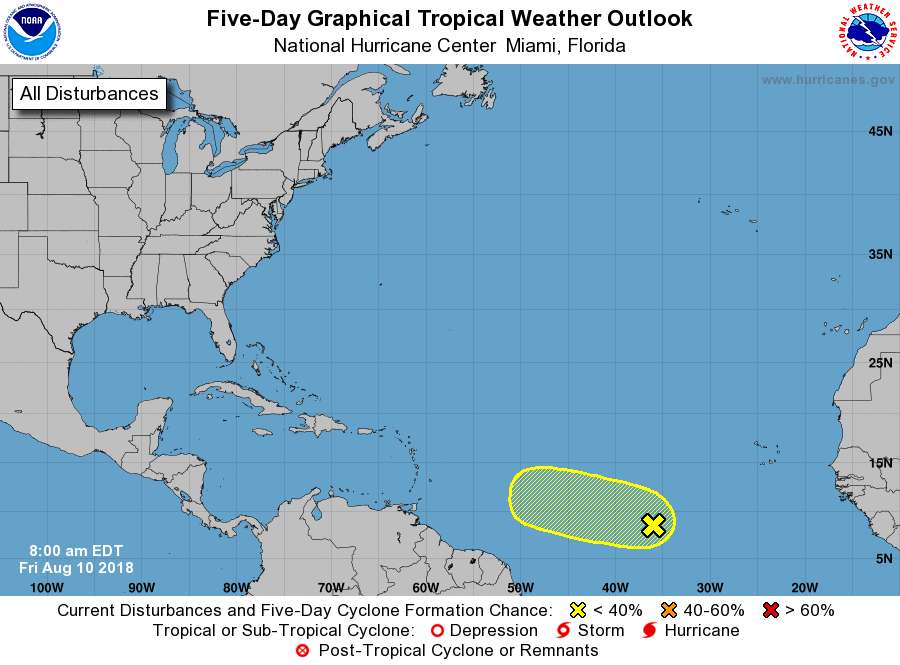
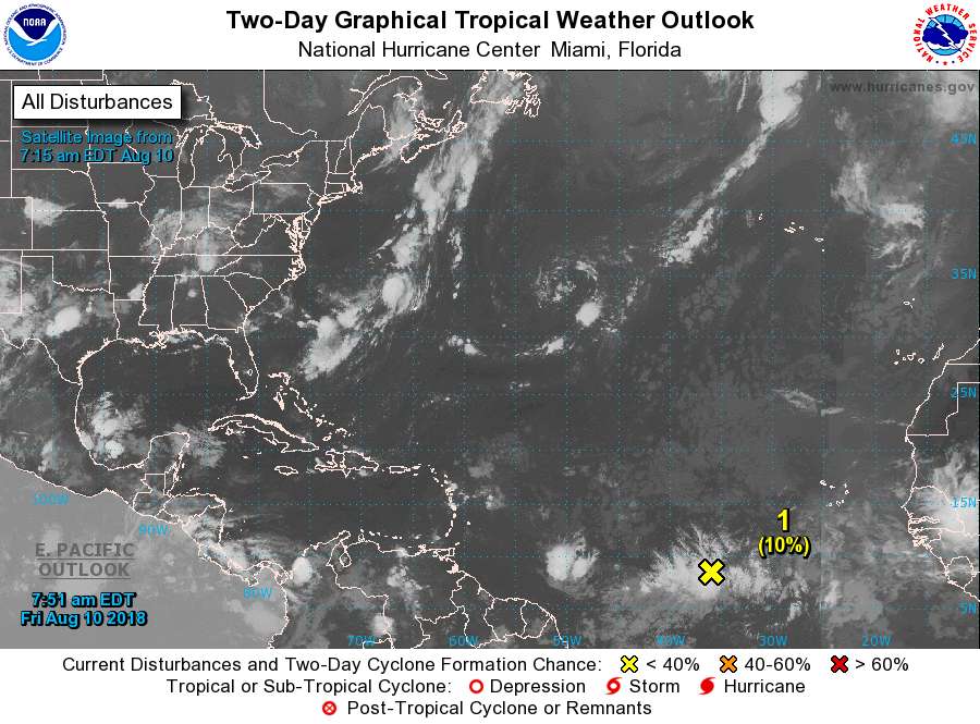
Tropical Weather Outlook
NWS National Hurricane Center Miami FL
800 AM EDT Fri Aug 10 2018
For the North Atlantic...Caribbean Sea and the Gulf of Mexico:
1. An area of disturbed weather is located about midway between Africa
and the Lesser Antilles. Environmental conditions are expected to
become conducive for some gradual development while the system moves
slowly west over the next few days. By the middle of next week,
stronger upper-level winds could limit the chance for further
development.
* Formation chance through 48 hours...low...10 percent.
* Formation chance through 5 days...low...20 percent.
Forecaster Zelinsky
Re: Nueva área a vigilar según TWO 8am del 10 agosto 2018
Posted: Fri Aug 10, 2018 10:18 am
by Villafañe
Saludos Migdalia y a todos los foristas, presente por aquí con este nuevo prospecto ciclónico, los modelos no le dan muchas oportunidades de desarrollo por el momento , sin embargo entramos en agosto así que ojo. Veremos
Re: Nueva área a vigilar según TWO 8am del 10 agosto 2018
Posted: Fri Aug 10, 2018 3:46 pm
by Villafañe
ZCZC MIATWOAT ALL
TTAA00 KNHC DDHHMM
Tropical Weather Outlook
NWS National Hurricane Center Miami FL
200 PM EDT Fri Aug 10 2018
For the North Atlantic...Caribbean Sea and the Gulf of Mexico:
1. An area of disturbed weather is located about midway between Africa
and the Lesser Antilles. Strong upper-level winds are likely to
limit development of this system for the next day or two, but some
gradual development is possible after that time while the system
moves slowly westward through early next week.
* Formation chance through 48 hours...low...10 percent.
* Formation chance through 5 days...low...20 percent.
Forecaster Zelinsky
Re: Nueva área a vigilar según TWO 8am del 10 agosto 2018
Posted: Fri Aug 10, 2018 8:07 pm
by Arlequín
Invest 99L al este de las Antillas Menores - 10 / 20
Posted: Wed Aug 15, 2018 11:01 pm
by Obi-Wan
Luego de estar un tiempo estacionaria y fuera del TWO por varios días, esta zona de mal tiempo vuelve a estar en el TWO de esta noche y adicionalmente con clasificación de Invest 99L con 10/20 posibilidad de desarrollo.
Se espera que pase al sur de nuestra zona entre domingo y lunes.
De llegar a convertirse en tormenta tropical llevaría el nombre de Florence.
Re: Invest 99L al este de las Antillas Menores - 10 / 20
Posted: Wed Aug 15, 2018 11:28 pm
by Arlequín
He estado observando los modelos últimamente con este sistema y lo mas que muestran es una fuerte onda tropical pasando las antillas menores...

Re: Invest 99L al este de las Antillas Menores - 10 / 20
Posted: Thu Aug 16, 2018 2:08 am
by Arlequín
EURO mostrando su corrida mas agresiva... pero apenas lo mantiene como onda tropical fuerte..

Re: Invest 99L al este de las Antillas Menores - 10 / 20
Posted: Thu Aug 16, 2018 3:19 am
by Abito
Estimado Arlequin y demas foristas: Con ojos de un aficionado a la meteorologia, me parece que el sistema esta expandiendo en tamaño, pero aparenta estar un poco menos concentrado. Creo que tiene un chin de circulacion . En resumen, no luce muy bonito, pero por lo menos es algo que se puede ser observado con algun interes, ya que podria ser el comienzo de mejores sistemas en esta temporada lenta y rara, con 4 de los cinco mas fuertes y organizados se originaron fuera del Main Development Region (MDR). Saludos a todos, Abito
Re: Invest 99L al este de las Antillas Menores - 10 / 20
Posted: Thu Aug 16, 2018 7:44 am
by edgardo
Tropical Weather Outlook
NWS National Hurricane Center Miami FL
800 AM EDT Thu Aug 16 2018
For the North Atlantic...Caribbean Sea and the Gulf of Mexico:
The National Hurricane Center is issuing advisories on Subtropical
Storm Ernesto located several hundred miles southeast of Cape Race,
Newfoundland.
A tropical wave located about 750 miles east-southeast of the
Windward Islands is producing a large area of disorganized
cloudiness and showers. Some gradual development of this system
is possible over the next couple of days while it moves west-
northwestward at 15 to 20 mph toward the Windward Islands. By late
Saturday, unfavorable environmental conditions should limit the
chances for additional development while the system moves over
the eastern Caribbean Sea. Regardless of development, this system is
likely to bring locally heavy rainfall to portions of the Lesser
Antilles during the next few days.
* Formation chance through 48 hours...low...10 percent.
* Formation chance through 5 days...low...20 percent.
Re: Invest 99L al este de las Antillas Menores - 10 / 20
Posted: Thu Aug 16, 2018 7:47 am
by Villafañe
Saludos a todos, Seguimos en observación a ver qué pasa con este disturbio tropical.
