Page 81 of 273
Re: Huracan Irma - Categoría 3
Posted: Fri Sep 01, 2017 9:57 pm
by CRASH
San Felipe II wrote: ↑Fri Sep 01, 2017 9:41 pm
CRASH wrote: ↑Fri Sep 01, 2017 8:36 pm
Lymaris saludos!
Creo q el movimiento wsw debe ser tomorrow
La longitud que se espera de el comienzo hacia abajo es la 40.9 según el último boletín de las 5:00 PM y noto en el radar que el huracán Irma ya pasó ese punto, me corrigen compañeros?
Saludos, creo que todavia no ha pasado la 40.9 maybe anda por la 40 o 40.1
Re: Huracan Irma - Categoría 3
Posted: Fri Sep 01, 2017 10:24 pm
by Lymaris
CRASH wrote: ↑Fri Sep 01, 2017 8:36 pm
Lymaris saludos!
Creo q el movimiento wsw debe ser tomorrow
Gracias! Hasta ahora todo sigue al pie de la letra, veremos mañana entonces!
Re: Huracan Irma - Categoría 3
Posted: Fri Sep 01, 2017 10:29 pm
by fanatica
Ok.... una pregunta porque el ojo se ve pequeño o casi invisible según lo veo en los mapas?
Re: Huracan Irma - Categoría 3
Posted: Fri Sep 01, 2017 10:32 pm
by Lymaris
fanatica wrote: ↑Fri Sep 01, 2017 10:29 pm
Ok.... una pregunta porque el ojo se ve pequeño o casi invisible según lo veo en los mapas?
Según n lo que han explicado los compañeris aquí, es por remplazo de paredes del ojo, equivalente a intensificación.
Re: Huracan Irma - Categoría 3
Posted: Fri Sep 01, 2017 10:34 pm
by San Felipe II
Me comentan varían personas que el huracán Irma esta demasiada alta y que esa posición influye muchísimo que PR no sufra algún azote, y porque el Centro Nacional de Huracanes estimó el mismo en una Latitud menor.
Re: Huracan Irma - Categoría 3
Posted: Fri Sep 01, 2017 10:47 pm
by CarlosP
Lymaris wrote: ↑Fri Sep 01, 2017 10:32 pm
fanatica wrote: ↑Fri Sep 01, 2017 10:29 pm
Ok.... una pregunta porque el ojo se ve pequeño o casi invisible según lo veo en los mapas?
Según n lo que han explicado los compañeris aquí, es por remplazo de paredes del ojo, equivalente a intensificación.
No 100% certero. Cuando ocurre reemplazo el sistema se debilita, pero el campo de vientos se expande considerablemente. Después, cuando retoma de nuevo la pared, se reintensifica y hasta desarrolla una segunda pared.
Re: Huracan Irma - Categoría 3
Posted: Fri Sep 01, 2017 10:48 pm
by digital77
000
WTNT31 KNHC 020242
TCPAT1
BULLETIN
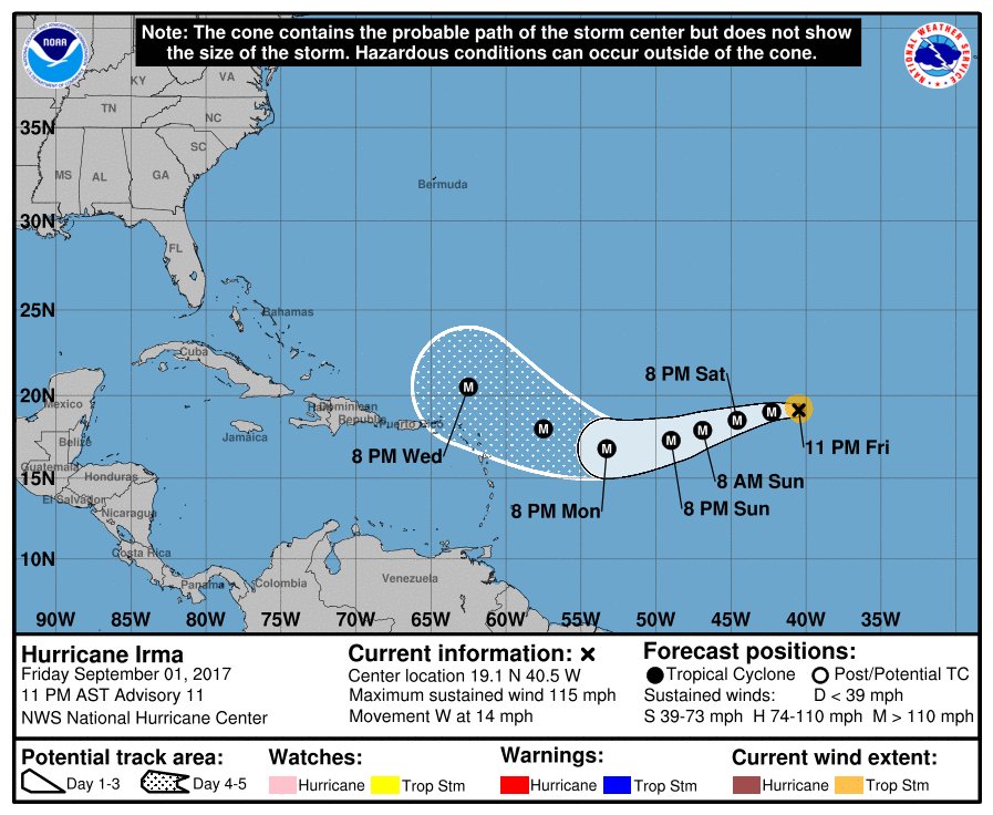
Hurricane Irma Advisory Number 11
NWS National Hurricane Center Miami FL AL112017
1100 PM AST Fri Sep 01 2017
...IRMA FLUCTUATING IN INTENSITY BUT STILL A POWERFUL HURRICANE...
SUMMARY OF 1100 PM AST...0300 UTC...INFORMATION
-----------------------------------------------
LOCATION...19.1N 40.5W
ABOUT 1405 MI...2260 KM E OF THE LEEWARD ISLANDS
MAXIMUM SUSTAINED WINDS...115 MPH...185 KM/H
PRESENT MOVEMENT...W OR 275 DEGREES AT 14 MPH...22 KM/H
MINIMUM CENTRAL PRESSURE...967 MB...28.56 INCHES
WATCHES AND WARNINGS
--------------------
There are no coastal watches or warnings in effect.
Interests in the northern Leeward Islands should monitor the
progress of this system.
DISCUSSION AND 48-HOUR OUTLOOK
------------------------------
At 1100 PM AST (0300 UTC), the center of Hurricane Irma was located
near latitude 19.1 North, longitude 40.5 West. Irma is moving toward
the west near 14 mph (22 km/h). A turn toward the west-southwest
is expected on Saturday.
Maximum sustained winds are near 115 mph (185 km/h) with higher
gusts. Irma is a category 3 hurricane on the Saffir-Simpson
Hurricane Wind Scale. Fluctuations in strength, up or down, are
possible during the next few days, but Irma is expected to remain a
powerful hurricane through the weekend.
Hurricane-force winds extend outward up to 25 miles (35 km) from the
center and tropical-storm-force winds extend outward up to 70 miles
(110 km).
The estimated minimum central pressure is 967 mb (28.56 inches).
HAZARDS AFFECTING LAND
----------------------
None
NEXT ADVISORY
-------------
Next complete advisory at 500 AM AST.
$$
Forecaster Zelinsky
Re: Huracan Irma - Categoría 3
Posted: Fri Sep 01, 2017 10:49 pm
by digital77
Due west. seguimos. Creo que ya en las proximas hoaras comenzara el tan wsw.
Re: Huracan Irma - Categoría 3
Posted: Fri Sep 01, 2017 10:52 pm
by StormWatch
Un poco más lejos! Veremos cuanto baja, la veo Oeste franco.......
Re: Huracan Irma - Categoría 3
Posted: Fri Sep 01, 2017 10:53 pm
by Lymaris
CarlosP wrote: ↑Fri Sep 01, 2017 10:47 pm
Lymaris wrote: ↑Fri Sep 01, 2017 10:32 pm
fanatica wrote: ↑Fri Sep 01, 2017 10:29 pm
Ok.... una pregunta porque el ojo se ve pequeño o casi invisible según lo veo en los mapas?
Según n lo que han explicado los compañeris aquí, es por remplazo de paredes del ojo, equivalente a intensificación.
No 100% certero. Cuando ocurre reemplazo el sistema se debilita, pero el campo de vientos se expande considerablemente. Después, cuando retoma de nuevo la pared, se reintensifica y hasta desarrolla una segunda pared.
Gracias por aclarar!!!

