
Tormenta Kirk

Re: Remanentes de Kirk (70%-70%)
Muy sospechoso este sistema, hablan de mucho shear, sin embargo observó las imágenes del satélite de vapor de agua y no se ve tan alto el shear, lo que se ve es la vaguada que está sobre Puerto Rico moviéndose al oeste y dándole más espacio a los remanentes de Kirk a una posible intensificación, Rockstorm mencionó lo de la vaguada retirándose al oeste. Lo dicho arriba es solo mi opinión. Veremos


Re: Remanentes de Kirk (70%-70%)
En mi vida yo he visto una onda tropical tan saludable, produciendo bandas en espiral, tronadas altas en el centro, con bastante simetría. Muy probable que ya sea tormenta tropical, o está proximo a serlo.Villafañe wrote: ↑Tue Sep 25, 2018 11:29 pm Muy sospechoso este sistema, hablan de mucho shear, sin embargo observó las imágenes del satélite de vapor de agua y no se ve tan alto el shear, lo que se ve es la vaguada que está sobre Puerto Rico moviéndose al oeste y dándole más espacio a los remanentes de Kirk a una posible intensificación, Rockstorm mencionó lo de la vaguada retirándose al oeste. Lo dicho arriba es solo mi opinión. Veremos
Re: Remanentes de Kirk (70%-70%)
Mi opinión es que si parece Tormenta y que el centro de circulación está cerrado a esta hora, veremos en la mañana las imágenes del visible si en fin es correcta mi observación..
cg1672 wrote: ↑Tue Sep 25, 2018 11:54 pmEn mi vida yo he visto una onda tropical tan saludable, produciendo bandas en espiral, tronadas altas en el centro, con bastante simetría. Muy probable que ya sea tormenta tropical, o está proximo a serlo.Villafañe wrote: ↑Tue Sep 25, 2018 11:29 pm Muy sospechoso este sistema, hablan de mucho shear, sin embargo observó las imágenes del satélite de vapor de agua y no se ve tan alto el shear, lo que se ve es la vaguada que está sobre Puerto Rico moviéndose al oeste y dándole más espacio a los remanentes de Kirk a una posible intensificación, Rockstorm mencionó lo de la vaguada retirándose al oeste. Lo dicho arriba es solo mi opinión. Veremos
Re: Remanentes de Kirk (70%-70%)
El shear devastador que se espera parece ser que no será de la vaguada que está sobre  la misma se retirara al oeste , según me informó un amigo meteorólogo serán los de Leslie.
 veremos
la misma se retirara al oeste , según me informó un amigo meteorólogo serán los de Leslie. veremosRe: Remanentes de Kirk (70%-70%)
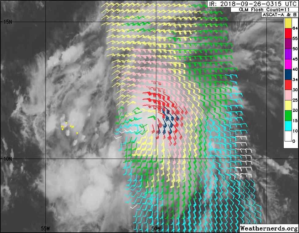
ASCAT de las 11:15 muestra una circulación cerrada en Kirk
-
StormWatch
- Cat. 3

- Posts: 3755
- Joined: Thu Aug 06, 2015 11:39 am
- Location: Texas, USA
Re: Remanentes de Kirk (70%-70%)
Para donde tú .........

Member Since 2005
For official information, please refer to NHC: https://www.nhc.noaa.gov
Hurricane’s hit Puerto Rico:
San Felipe 1928, San Ciprián 1932, Santa Clara 1956, Hugo 1989, Marilyn 1995, Hortense 1996, Georges 1998, Maria 2017, Fiona 2022
Model Runs:
GFS:
[5:30 AM/PM, 11:30 AM/PM]
HWRF, GFDL, UKMET, NAVGEM:
[6:30-8:00 AM/PM, 12:30-2:00 AM/PM]
ECMWF:
[1:45 AM/PM]
-
StormWatch
- Cat. 3
- Posts: 3755
- Joined: Thu Aug 06, 2015 11:39 am
- Location: Texas, USA
Re: Remanentes de Kirk (70%-70%)
90% -90%
As of 2:00 am EDT Wed Sep 26 2018 ...
Thunderstorm activity has increased and become better organized in
association with the remnants of Kirk located about 650 miles east
of the Windward Islands. Recent satellite-derived wind data also
indicate that the circulation has become better defined and that the
winds have increased. If this development trend continues, then
advisories will be re-initiated on this system later this morning.
Interests in the Windward and Leeward Islands should monitor the
progress of this disturbance. An Air Force Reserve reconnaissance
aircraft is schedule to investigate this disturbance later today.
For more information on this system, see High Seas Forecasts issued
by the National Weather Service.
* Formation chance through 48 hours...high...90 percent.
* Formation chance through 5 days...high...90 percent.
Member Since 2005
For official information, please refer to NHC: https://www.nhc.noaa.gov
Hurricane’s hit Puerto Rico:
San Felipe 1928, San Ciprián 1932, Santa Clara 1956, Hugo 1989, Marilyn 1995, Hortense 1996, Georges 1998, Maria 2017, Fiona 2022
Model Runs:
GFS:
[5:30 AM/PM, 11:30 AM/PM]
HWRF, GFDL, UKMET, NAVGEM:
[6:30-8:00 AM/PM, 12:30-2:00 AM/PM]
ECMWF:
[1:45 AM/PM]
For official information, please refer to NHC: https://www.nhc.noaa.gov
Hurricane’s hit Puerto Rico:
San Felipe 1928, San Ciprián 1932, Santa Clara 1956, Hugo 1989, Marilyn 1995, Hortense 1996, Georges 1998, Maria 2017, Fiona 2022
Model Runs:
GFS:
[5:30 AM/PM, 11:30 AM/PM]
HWRF, GFDL, UKMET, NAVGEM:
[6:30-8:00 AM/PM, 12:30-2:00 AM/PM]
ECMWF:
[1:45 AM/PM]
-
Laniña2016
- Invest

- Posts: 212
- Joined: Sat May 28, 2016 7:19 am
Re: Remanentes de Kirk (70%-70%)
064
WTNT32 KNHC 260836
TCPAT2
BULLETIN
Tropical Storm Kirk Advisory Number 10
NWS National Hurricane Center Miami FL AL122018
500 AM AST Wed Sep 26 2018
...KIRK REGENERATES INTO A TROPICAL STORM OVER THE WESTERN TROPICAL
ATLANTIC...
...TROPICAL STORM WARNINGS AND WATCHES ISSUED FOR PORTIONS OF THE
LESSER ANTILLES...
SUMMARY OF 500 AM AST...0900 UTC...INFORMATION
----------------------------------------------
LOCATION...11.8N 52.7W
ABOUT 470 MI...755 KM E OF BARBADOS
ABOUT 595 MI...955 KM ESE OF MARTINIQUE
MAXIMUM SUSTAINED WINDS...45 MPH...75 KM/H
PRESENT MOVEMENT...W OR 280 DEGREES AT 18 MPH...30 KM/H
MINIMUM CENTRAL PRESSURE...1004 MB...29.65 INCHES
WATCHES AND WARNINGS
--------------------
CHANGES WITH THIS ADVISORY:
The government of Barbados has issued a Tropical Storm Warning for
Barbados. The government of St. Lucia has issued a Tropical Storm
Warning for St. Lucia.
The government of Barbados has issued a Tropical Storm Watch for
St. Vincent and the Grenadines.
SUMMARY OF WATCHES AND WARNINGS IN EFFECT:
A Tropical Storm Warning is in effect for...
* Barbados
* St. Lucia
A Tropical Storm Watch is in effect for...
* St. Vincent and the Grenadines
A Tropical Storm Warning means that tropical storm conditions are
expected somewhere within the warning area within 36 hours.
A Tropical Storm Watch means that tropical storm conditions are
possible within the watch area, in this case within 36 hours.
Interests elsewhere in the central and northern Lesser Antilles
should monitor the progress of Kirk as additional warnings or
watches could be issued later today.
For storm information specific to your area, please monitor
products issued by your national meteorological service.
DISCUSSION AND OUTLOOK
----------------------
At 500 AM AST (0900 UTC), the center of Tropical Storm Kirk was
located near latitude 11.8 North, longitude 52.7 West. Kirk is
moving toward the west near 18 mph (30 km/h). A westward to
west-northwestward motion is expected through Friday night. On the
forecast track, Kirk is expected to approach Barbados and the
northern Windward Islands Thursday afternoon and move into the
eastern Caribbean Sea by Friday morning.
Maximum sustained winds are near 45 mph (75 km/h) with higher gusts.
Little change in strength is forecast until Kirk moves through the
central Lesser Antilles Thursday afternoon and evening. Rapid
weakening is expected on Friday after Kirk emerges over the
Caribbean Sea.
Tropical-storm-force winds extend outward up to 115 miles (185 km)
from the center.
The estimated minimum central pressure is 1004 mb (29.65 inches).
HAZARDS AFFECTING LAND
----------------------
WIND: Tropical storm conditions are expected to first reach the
warning area by Thursday afternoon, making outside preparations
difficult or dangerous. Tropical storm conditions are possible
within the watch area by Thursday afternoon or evening.
RAINFALL: Kirk is expected to produce total rainfall totals of
4 to 6 inches with maximum totals of 10 across the northern Windward
and southern Leeward Islands from Barbados and St. Lucia northward
across Martinique, Dominica, and Guadeloupe. These rains may
produce life-threatening flash floods and mudslides.
NEXT ADVISORY
-------------
Next intermediate advisory at 800 AM AST.
Next complete advisory at 1100 AM AST.
Re: Remanentes de Kirk (70%-70%)

...the resurrection