
Tormenta Hermine (Invest 99L)
-
categoria5
- Onda Tropical

- Posts: 46
- Joined: Mon Aug 17, 2015 12:33 am
Re: Invest 99L al Este de Antillas Menores 50%-70%
-
ROCKstormSJ4315

- Tormenta Tropical

- Posts: 888
- Joined: Tue Aug 06, 2013 10:09 pm
- Location: Hato Rey, San Juan, PR
Re: Invest 99L al Este de Antillas Menores 50%-70%
Interesante la ultima discusion de la oficina del NWS en San Juan:
"Area Forecast Discussion
National Weather Service San Juan PR
958 PM AST TUE AUG 23 2016
.UPDATE...Strong tropical wave continues to get better organized
as it moves closer to the local area. As 8 pm AST...the latest
Tropical Weather Outlook from the National Hurricane Center
indicated there is a 50% chance of this system to develop into a
tropical depression the next day or two. Band of showers
associated with this system are spreading across the coastal
waters...with some showers approaching the northern coastal
waters. These showers will be more frequent overnight as the
Tropical Wave approaches the local area. Flash flood watch will be
in effect early Wednesday morning through at least Wednesday
night. Residents and visitors in Puerto Rico and the U.S. Virgin
Islands should closely monitor the progress of this system. Stay
tuned.
&&
.AVIATION...Strong tropical wave just east of the Leeward terminals
will continue to move west-northwest through the fcst period,
impacting all terminals. SHRA/TSRA associated to the wave will
result mainly in MVFR conds to tempo IFR. Showers and TSTMS are
increasing across the Atlantic waters and are expected to become
more frequent after 06z across the northern terminals of PR/USVI and
the leeward terminals. Low level winds expected to continue ENE at 7-
15 knots thru 12z...veering ESE afterwards. Gusty winds between 25-
35 kts possible with TSRA".
"Georgy Girl", The Seekers
"Back for Good", Take That
"Perfectionist", SAGA
"Graves Into Gardens", Elevation Worship ft. Brandon Lake
"Thunder", Imagine Dragons
"Viva la Vida", Coldplay
"Back for Good", Take That
"Perfectionist", SAGA
"Graves Into Gardens", Elevation Worship ft. Brandon Lake
"Thunder", Imagine Dragons
"Viva la Vida", Coldplay
-
categoria5
- Onda Tropical
- Posts: 46
- Joined: Mon Aug 17, 2015 12:33 am
Re: Invest 99L al Este de Antillas Menores 50%-70%
-
huracan_1975
- Tormenta Tropical
- Posts: 630
- Joined: Sun Aug 16, 2015 9:59 am
Re: Invest 99L al Este de Antillas Menores 50%-70%
el GFS moviendo una tormenta a 190 horas y siguientes de oeste , al oeste suroeste , y llegando a PR,, ummmm sera verdad ?
-
categoria5
- Onda Tropical
- Posts: 46
- Joined: Mon Aug 17, 2015 12:33 am
-
huracan_1975
- Tormenta Tropical
- Posts: 630
- Joined: Sun Aug 16, 2015 9:59 am
Re: Invest 99L al Este de Antillas Menores 50%-70%
esto se mueve directo al oeste . que ustedes creen o es mi visión ?
-
huracan sur
- Depresión Tropical

- Posts: 400
- Joined: Wed Sep 04, 2013 3:26 am
Re: Invest 99L al Este de Antillas Menores 50%-70%
Saludos muchachos por aqui presente como de costumbre pendiente al kiosko a estas horas como tambien Rock",
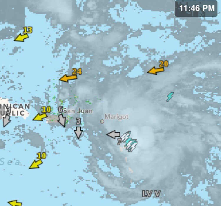
Mirando ambas imagenes tanto shortwave como el radar de martinica, se ve una consolidacion del posible LLC dominante, ya no se ve claramente ese aparente MLC que habia temprano en la noche cerca a la 15.8n y tampoco otro que habia cerca a la 17.2n
Se ve una consolidacion justo o sobre el NNE de Guadalupe, atentos.
Mi opinion muy personal no veo mucho cambio en el proximo TWO que esta por ahi ya, y nuestro 99L todavia tiene el chance de lograrlo, pero si no, ya estamos "curaos de espanto" de los " casi ciclones" a nuestra puerta
Para información oficial favor referirse a las agencias pertinentes. Un aficionado a la meteorología #TeamCycloforums
-
YankeeStorm

- Invest

- Posts: 117
- Joined: Tue Aug 06, 2013 11:30 pm
- Location: Yankees 27 Championships - Red Sox 3 Championships
Re: Invest 99L al Este de Antillas Menores 50%-70%
aqui se nota clarito en el radar de Guadalupe http://flhurricane.com/imageanimator.php?214
Refer to National Hurricane Center
-
huracan_1975
- Tormenta Tropical
- Posts: 630
- Joined: Sun Aug 16, 2015 9:59 am
Re: Invest 99L al Este de Antillas Menores 50%-70%
centro justo en Guadalupe ....
-
StormWatch
- Cat. 3

- Posts: 3755
- Joined: Thu Aug 06, 2015 11:39 am
- Location: Texas, USA
Re: Invest 99L al Este de Antillas Menores 50%-70%
El boletin de las 2am 80-90...Ya en breve...
Member Since 2005
For official information, please refer to NHC: https://www.nhc.noaa.gov
Hurricane’s hit Puerto Rico:
San Felipe 1928, San Ciprián 1932, Santa Clara 1956, Hugo 1989, Marilyn 1995, Hortense 1996, Georges 1998, Maria 2017, Fiona 2022
Model Runs:
GFS:
[5:30 AM/PM, 11:30 AM/PM]
HWRF, GFDL, UKMET, NAVGEM:
[6:30-8:00 AM/PM, 12:30-2:00 AM/PM]
ECMWF:
[1:45 AM/PM]