
Tormenta Hermine (Invest 99L)
-
huracan sur
- Depresión Tropical

- Posts: 400
- Joined: Wed Sep 04, 2013 3:26 am
Re: Invest 99L al Este de Antillas Menores 50%-60%
Nada mas con el testigo busquen el radar de martinica y veran la rotacion al ESE de Guadalupe 
Para información oficial favor referirse a las agencias pertinentes. Un aficionado a la meteorología #TeamCycloforums
-
hurrizonepr
- Depresión Tropical
- Posts: 451
- Joined: Wed Sep 04, 2013 10:30 am
Re: Invest 99L al Este de Antillas Menores 50%-60%
Pronto perderemos las imagenes visibles,que nos ayudan tanto  . Pero trataremos de descifrar las otras imagenes con la ayuda y experiencia de los expertos del foro. la noche se presenta interesante...
-
Thunderstruck

- Onda Tropical

- Posts: 19
- Joined: Thu Aug 20, 2015 8:17 pm
Re: Invest 99L al Este de Antillas Menores 50%-60%
Esta noche hay Vigiiiiiliaaaaa!!!
En Puerto Rico cuando no es sequia es Huracán..........
-
Thunderstruck
- Onda Tropical
- Posts: 19
- Joined: Thu Aug 20, 2015 8:17 pm
Re: Invest 99L al Este de Antillas Menores 50%-60%
http://www.ssd.noaa.gov/goes/east/carb/ft-animated.gif
Me parece que sorpresa nos treará esta noche....
Me parece que sorpresa nos treará esta noche....
En Puerto Rico cuando no es sequia es Huracán..........
-
StormWatch
- Cat. 3

- Posts: 3755
- Joined: Thu Aug 06, 2015 11:39 am
- Location: Texas, USA
Re: Invest 99L al Este de Antillas Menores 50%-60%
Invest 99L view! 

Member Since 2005
For official information, please refer to NHC: https://www.nhc.noaa.gov
Hurricane’s hit Puerto Rico:
San Felipe 1928, San Ciprián 1932, Santa Clara 1956, Hugo 1989, Marilyn 1995, Hortense 1996, Georges 1998, Maria 2017, Fiona 2022
Model Runs:
GFS:
[5:30 AM/PM, 11:30 AM/PM]
HWRF, GFDL, UKMET, NAVGEM:
[6:30-8:00 AM/PM, 12:30-2:00 AM/PM]
ECMWF:
[1:45 AM/PM]
-
StormWatch
- Cat. 3
- Posts: 3755
- Joined: Thu Aug 06, 2015 11:39 am
- Location: Texas, USA
Re: Invest 99L al Este de Antillas Menores 50%-60%
Se acaba el Sol.......... Nice spin! Yessssssssss!

Member Since 2005
For official information, please refer to NHC: https://www.nhc.noaa.gov
Hurricane’s hit Puerto Rico:
San Felipe 1928, San Ciprián 1932, Santa Clara 1956, Hugo 1989, Marilyn 1995, Hortense 1996, Georges 1998, Maria 2017, Fiona 2022
Model Runs:
GFS:
[5:30 AM/PM, 11:30 AM/PM]
HWRF, GFDL, UKMET, NAVGEM:
[6:30-8:00 AM/PM, 12:30-2:00 AM/PM]
ECMWF:
[1:45 AM/PM]
For official information, please refer to NHC: https://www.nhc.noaa.gov
Hurricane’s hit Puerto Rico:
San Felipe 1928, San Ciprián 1932, Santa Clara 1956, Hugo 1989, Marilyn 1995, Hortense 1996, Georges 1998, Maria 2017, Fiona 2022
Model Runs:
GFS:
[5:30 AM/PM, 11:30 AM/PM]
HWRF, GFDL, UKMET, NAVGEM:
[6:30-8:00 AM/PM, 12:30-2:00 AM/PM]
ECMWF:
[1:45 AM/PM]
Re: Invest 99L al Este de Antillas Menores 50%-60%
8pm Satellite images, surface observations, and radar from the Lesser
Antilles indicate that a broad area of low pressure associated
with a tropical wave a couple of hundred miles east of the Lesser
Antilles has become a little better defined. Although environmental
conditions are only marginally conducive for development, this
system could become a tropical depression during the next day
or two while it moves west-northwest at 15 to 20 mph near the
Leeward Islands and the Greater Antilles. Conditions could become
more conducive later this week while the system moves near the
southeastern and central Bahamas. Another Air Force Reserve
Hurricane Hunter aircraft is scheduled to investigate this
disturbance tomorrow, if necessary. Interests from the islands of
the northeastern Caribbean Sea to the Bahamas should continue to
monitor the progress of this system. Gusty winds, heavy rains, and
possible flash floods and mud slides could occur over portions of
these areas regardless of tropical cyclone formation.
Please consult products issued by your local meteorological offices
for further details.
* Formation chance through 48 hours...medium...50 percent
* Formation chance through 5 days...high...70 percent
emh- huracan es simplemente ahora Edgardo. Importante: Phil Klotzbach, recordó que "el mejor momento para prepararse para los huracanes es cuando todavía no hay huracanes".

Re: Invest 99L al Este de Antillas Menores 50%-60%
Comeback??

Siempre la Madre Naturaleza es la última que ríe.
-
hurrizonepr
- Depresión Tropical
- Posts: 451
- Joined: Wed Sep 04, 2013 10:30 am
Re: Invest 99L al Este de Antillas Menores 50%-60%
El NHC relocalizo la baja presion mas al sur como habiamos comentado muchos en el foro. Ahora estamos de nuevo en el centro del cono de trayectoria.  Ya con un 50-70% puede haber sorpresas antes de entrar al Noreste del Caribe en nuestra direccion.
Re: Invest 99L al Este de Antillas Menores 50%-60%
Para observar sistemas de noche, esta es una buena herramienta.
http://www.ssd.noaa.gov/PS/TROP/floater ... -long.html
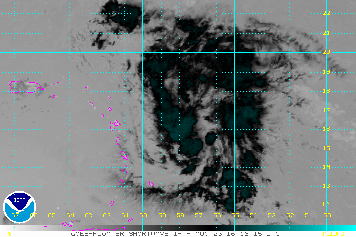
http://www.ssd.noaa.gov/PS/TROP/floater ... -long.html

Siempre la Madre Naturaleza es la última que ríe.