Re: Huracán Isaac
Posted: Tue Sep 11, 2018 10:57 am
BULLETIN
Tropical Storm Isaac Advisory Number 16
NWS National Hurricane Center Miami FL AL092018
1100 AM AST Tue Sep 11 2018
...HURRICANE AND TROPICAL STORM WATCHES ISSUED FOR ISAAC...
SUMMARY OF 1100 AM AST...1500 UTC...INFORMATION
-----------------------------------------------
LOCATION...14.6N 49.7W
ABOUT 775 MI...1250 KM E OF THE LESSER ANTILLES
MAXIMUM SUSTAINED WINDS...70 MPH...110 KM/H
PRESENT MOVEMENT...W OR 270 DEGREES AT 16 MPH...26 KM/H
MINIMUM CENTRAL PRESSURE...996 MB...29.42 INCHES
WATCHES AND WARNINGS
--------------------
CHANGES WITH THIS ADVISORY:
The government of France has issued a Hurricane Watch for Guadeloupe
and Martinique.
The government of Barbados has issued a Hurricane Watch for
Dominica.
The meteorological service of Antigua and Barbuda has issued a
Tropical Storm Watch for Antigua and Montserrat.
SUMMARY OF WATCHES AND WARNINGS IN EFFECT:
A Hurricane Watch is in effect for...
* Guadeloupe
* Martinique
* Dominica
A Tropical Storm Watch is in effect for...
* Antigua and Montserrat
A Hurricane Watch means that hurricane conditions are possible
within the watch area. A watch is typically issued 48 hours
before the anticipated first occurrence of tropical-storm-force
winds, conditions that make outside preparations difficult or
dangerous.
A Tropical Storm Watch means that tropical storm conditions are
possible within the watch area, generally within 48 hours.
Interests elsewhere in the Leeward Islands should monitor the
progress of Isaac as additional watches could be issued this
afternoon or evening.
For storm information specific to your area, please monitor
products issued by your national meteorological service.
DISCUSSION AND OUTLOOK
----------------------
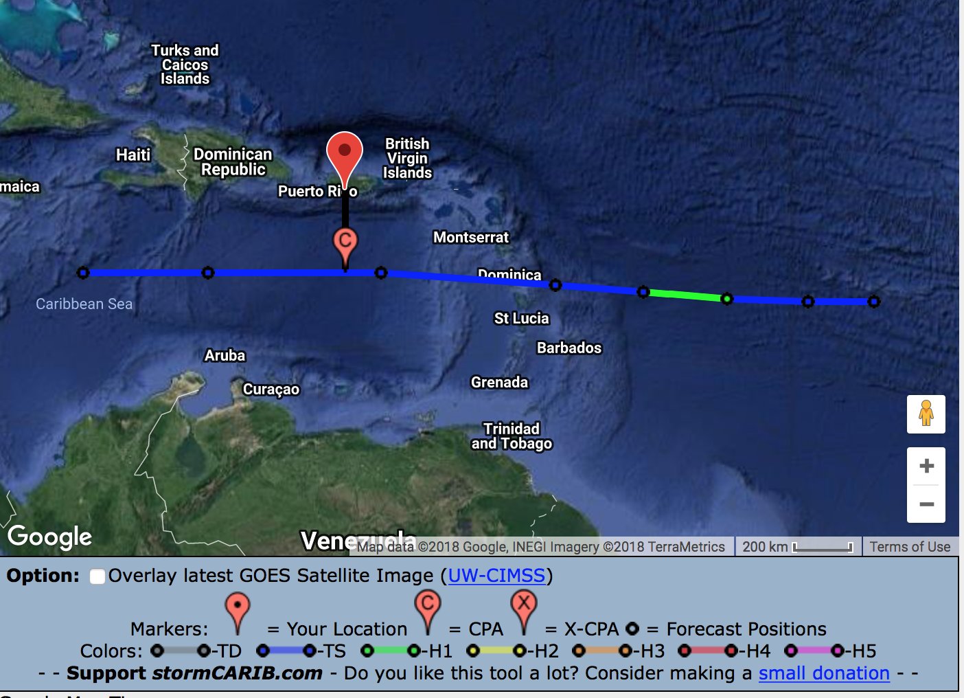
At 1100 AM AST (1500 UTC), the center of Tropical Storm Isaac was
located near latitude 14.6 North, longitude 49.7 West. Isaac is
moving toward the west near 16 mph (26 km/h) and this motion is
expected to continue for the next few days. On the forecast track
Isaac is anticipated to move near or over the central Lesser
Antilles on Thursday and move into the eastern Caribbean Sea
Thursday night.
Maximum sustained winds remain near 70 mph (110 km/h) with higher
gusts. Isaac is expected to be near hurricane strength when it
moves through the central Lesser Antilles, with some weakening
forecast afterward on Friday.
Tropical-storm-force winds extend outward up to 105 miles (165 km)
from the center.
The estimated minimum central pressure is 996 mb (29.42 inches).
HAZARDS AFFECTING LAND
----------------------
RAINFALL: Isaac is expected to produce total rainfall accumulations
of 3 to 5 inches with isolated amounts near 10 inches across the
southern Leeward Islands late this week, with 1 to 2 inches
anticipated across portions of the Windward Islands.
STORM SURGE: A storm surge of 2 to 4 feet above normal tide levels
is possible near and to the north of where the center moves through
the Lesser Antilles. Near the coast, the surge will be accompanied
by large and destructive waves.
WIND: Hurricane conditions are possible within the hurricane watch
area by Thursday morning, with tropical storm conditions possible
early Thursday in both the hurricane and tropical storm watch areas.
SURF: Swells generated by Isaac will begin to affect portions
of the Lesser Antilles on Wednesday afternoon. These swells are
likely to cause life-threatening surf and rip current conditions.
Please consult products from your local weather office.
NEXT ADVISORY
-------------
Next intermediate advisory at 200 PM AST.
Next complete advisory at 500 PM AST.
$$
Forecaster Blake
Tropical Storm Isaac Advisory Number 16
NWS National Hurricane Center Miami FL AL092018
1100 AM AST Tue Sep 11 2018
...HURRICANE AND TROPICAL STORM WATCHES ISSUED FOR ISAAC...
SUMMARY OF 1100 AM AST...1500 UTC...INFORMATION
-----------------------------------------------
LOCATION...14.6N 49.7W
ABOUT 775 MI...1250 KM E OF THE LESSER ANTILLES
MAXIMUM SUSTAINED WINDS...70 MPH...110 KM/H
PRESENT MOVEMENT...W OR 270 DEGREES AT 16 MPH...26 KM/H
MINIMUM CENTRAL PRESSURE...996 MB...29.42 INCHES
WATCHES AND WARNINGS
--------------------
CHANGES WITH THIS ADVISORY:
The government of France has issued a Hurricane Watch for Guadeloupe
and Martinique.
The government of Barbados has issued a Hurricane Watch for
Dominica.
The meteorological service of Antigua and Barbuda has issued a
Tropical Storm Watch for Antigua and Montserrat.
SUMMARY OF WATCHES AND WARNINGS IN EFFECT:
A Hurricane Watch is in effect for...
* Guadeloupe
* Martinique
* Dominica
A Tropical Storm Watch is in effect for...
* Antigua and Montserrat
A Hurricane Watch means that hurricane conditions are possible
within the watch area. A watch is typically issued 48 hours
before the anticipated first occurrence of tropical-storm-force
winds, conditions that make outside preparations difficult or
dangerous.
A Tropical Storm Watch means that tropical storm conditions are
possible within the watch area, generally within 48 hours.
Interests elsewhere in the Leeward Islands should monitor the
progress of Isaac as additional watches could be issued this
afternoon or evening.
For storm information specific to your area, please monitor
products issued by your national meteorological service.
DISCUSSION AND OUTLOOK
----------------------
At 1100 AM AST (1500 UTC), the center of Tropical Storm Isaac was
located near latitude 14.6 North, longitude 49.7 West. Isaac is
moving toward the west near 16 mph (26 km/h) and this motion is
expected to continue for the next few days. On the forecast track
Isaac is anticipated to move near or over the central Lesser
Antilles on Thursday and move into the eastern Caribbean Sea
Thursday night.
Maximum sustained winds remain near 70 mph (110 km/h) with higher
gusts. Isaac is expected to be near hurricane strength when it
moves through the central Lesser Antilles, with some weakening
forecast afterward on Friday.
Tropical-storm-force winds extend outward up to 105 miles (165 km)
from the center.
The estimated minimum central pressure is 996 mb (29.42 inches).
HAZARDS AFFECTING LAND
----------------------
RAINFALL: Isaac is expected to produce total rainfall accumulations
of 3 to 5 inches with isolated amounts near 10 inches across the
southern Leeward Islands late this week, with 1 to 2 inches
anticipated across portions of the Windward Islands.
STORM SURGE: A storm surge of 2 to 4 feet above normal tide levels
is possible near and to the north of where the center moves through
the Lesser Antilles. Near the coast, the surge will be accompanied
by large and destructive waves.
WIND: Hurricane conditions are possible within the hurricane watch
area by Thursday morning, with tropical storm conditions possible
early Thursday in both the hurricane and tropical storm watch areas.
SURF: Swells generated by Isaac will begin to affect portions
of the Lesser Antilles on Wednesday afternoon. These swells are
likely to cause life-threatening surf and rip current conditions.
Please consult products from your local weather office.
NEXT ADVISORY
-------------
Next intermediate advisory at 200 PM AST.
Next complete advisory at 500 PM AST.
$$
Forecaster Blake