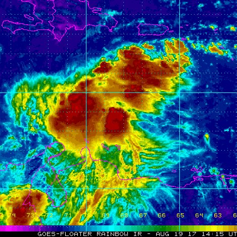
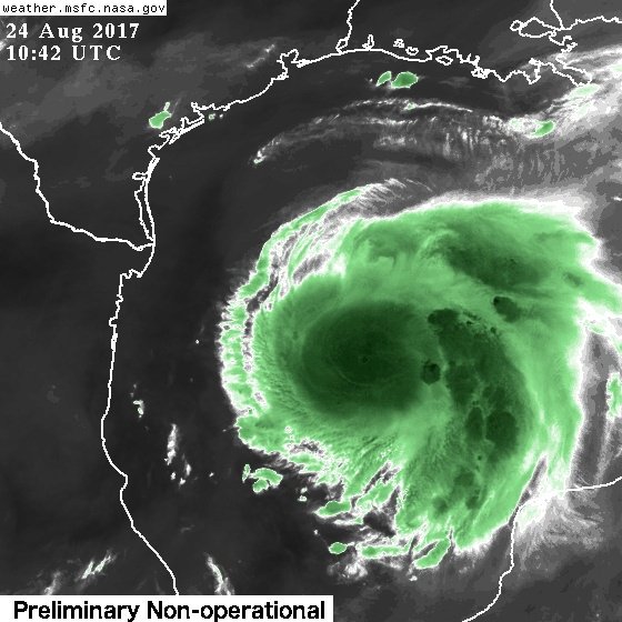
Lo veo solo un poco arriba. Sin embargo el q se ve brutal hacia el Oeste (por ahora) es el Invest 92Lfanatica wrote: ↑Thu Aug 17, 2017 9:10 pm Buenas noches por fin pude entrar jeje pero aquí estoy, vi este mapa y veo como la línea yo le digo la cadena del perro, se mueve un poco arriba, si alguien lo puede ver me dicen. Vamos a ver....
http://my.sfwmd.gov/sfwmd/common/images ... t_anim.gif
Harvey
-
StormWatch
- Cat. 3

- Posts: 3755
- Joined: Thu Aug 06, 2015 11:39 am
- Location: Texas, USA
Re: Tormenta Tropical Harvey
Member Since 2005
For official information, please refer to NHC: https://www.nhc.noaa.gov
Hurricane’s hit Puerto Rico:
San Felipe 1928, San Ciprián 1932, Santa Clara 1956, Hugo 1989, Marilyn 1995, Hortense 1996, Georges 1998, Maria 2017, Fiona 2022
Model Runs:
GFS:
[5:30 AM/PM, 11:30 AM/PM]
HWRF, GFDL, UKMET, NAVGEM:
[6:30-8:00 AM/PM, 12:30-2:00 AM/PM]
ECMWF:
[1:45 AM/PM]
Re: Tormenta Tropical Harvey
Sí es verdad.... hay que vigilar uno nunca sabe que pueda pasar.
Re: Tormenta Tropical Harvey
ROCKstormSJ4315 wrote: ↑Thu Aug 17, 2017 9:00 pm Vi este sistema en la manana y ahora y tengo que decir que su estructura luce. No hay forma en que pueda ver su circulacion. Si no fuera porque el caza dio la informacion oficial seria dificil de creer. Aunque tampoco muy impresionante, la 92 luce mejor. Esta llegando a la longitud 60 aun muy baja. Tiene que subir por encima de la latitud 15 antes, de lo contrario se ira lo mas probable por debajo de la Isla. Lo unico que veo Interesante es que los D fix y Los M fix los estan ajustado mas al norte segun pasa el tiempo. Si nos dejaramos llevar por esos ajustes, pareciera que se quiere mover oeste a oeste-noroeste. Queda poco tiempo para perderla al sur. Vamos a ver que hace en las proximas horas.

Si segun esto esta un poco mas al norte de lo pronosticad
- ROCKstormSJ4315
- Tormenta Tropical

- Posts: 888
- Joined: Tue Aug 06, 2013 10:09 pm
- Location: Hato Rey, San Juan, PR
Re: Tormenta Tropical Harvey
El TWD de las 5 de la manana del NHC, me gusta lo que esta en rojo: 
"Tropical Storm Harvey Discussion Number 4
NWS National Hurricane Center Miami FL AL092017
500 AM AST Fri Aug 18 2017
Harvey's cloud pattern has changed very little in organization
during the past several hours. The low-level center is difficult to
find even using the 1-min images from GOES 16, but it appears to
be located on the eastern edge of the convection due to the
prevailing easterly shear. Dvorak estimates from both TAFB
and SAB support keeping the intensity at 35 kt. Another Air
Force plane will be investigating Harvey at sunrise.
The moderate easterly shear affecting the cyclone is expected to
increase a little during the next day or so, and this factor should
not allow significant strengthening. Once the cyclone reaches the
western Caribbean Sea in 3 or 4 days, an environment of lower shear
and high moisture is forecast to prevail, and Harvey should then
gather some strength. The cyclone could be near hurricane strength
by the time it is approaching Central America or the Yucatan
peninsula. The NHC forecast is very similar to the previous one and
is very close to the intensity consensus. The GFS and the ECMWF
global models are just a little more enthusiastic in keeping the
cyclone from dissipating in this last run, but who knows what they
might forecast the next time.
Harvey has not changed in track or speed, and it is still moving
toward the west or 270 degrees at 16 kt. The cyclone is well
embedded within the easterlies south of a persistent subtropical
ridge. This steering pattern will keep Harvey trapped in the
Caribbean Sea while moving westward for the next few days. The
track forecast is similar to the one issued by my predecessor and it
follows closely the multi-model consensus. The guidance envelope is
quite tight and is bounded by the northernmost ECMWF and the GFS to
the south.
FORECAST POSITIONS AND MAX WINDS
INIT 18/0900Z 13.1N 59.1W 35 KT 40 MPH
12H 18/1800Z 13.2N 61.7W 35 KT 40 MPH
24H 19/0600Z 13.5N 65.2W 40 KT 45 MPH
36H 19/1800Z 13.9N 68.8W 40 KT 45 MPH
48H 20/0600Z 14.1N 72.7W 50 KT 60 MPH
72H 21/0600Z 15.0N 80.2W 60 KT 70 MPH
96H 22/0600Z 16.5N 86.5W 60 KT 70 MPH
120H 23/0600Z 17.5N 90.0W 35 KT 40 MPH...INLAND
$$
Forecaster Avila"
Parece que no estoy solo en mi guerra con los modelos de trayectoria.
"Georgy Girl", The Seekers
"Back for Good", Take That
"Perfectionist", SAGA
"Graves Into Gardens", Elevation Worship ft. Brandon Lake
"Thunder", Imagine Dragons
"Viva la Vida", Coldplay
"Back for Good", Take That
"Perfectionist", SAGA
"Graves Into Gardens", Elevation Worship ft. Brandon Lake
"Thunder", Imagine Dragons
"Viva la Vida", Coldplay
Re: Tormenta Tropical Harvey
parece que dejara buena lluvia en rep dom


Re: Depression Tropical Harvey
Tropical Depression Harvey Discussion Number 10
NWS National Hurricane Center Miami FL AL092017
500 PM EDT Sat Aug 19 2017
The cloud pattern of Harvey has continued to decay during the day,
at least in part due to 15-20 kt of northerly shear. The convective
area near the center is neither very concentrated or curved, and
overall the pattern more resembles that of an open wave than a
tropical cyclone. Based on the decay and data from the aircraft
mission this morning, the cyclone is downgraded to a tropical
depression. Another Air Force Reserve Hurricane Hunter aircraft
will investigate the system this evening to see if the circulation
still exists.
The intensity forecast is problematic. The current shear should
subside over the next 24 h, and the statistical guidance responds
to this by forecasting significant strengthening. On the other
hand, the structure of the cyclone has decayed to the point where
it may not be able to take advantage of the better environment, as
suggested by the ECMWF and GFS. The intensity forecast follows the
trend of the previous forecast, albeit with lower intensities, in
showing gradual strengthening until landfall in Belize or Yucatan.
However, an alternative forecast scenario is that the system
degenerates to an open wave and is unable to regenerate during the
next 72 h.
The initial motion remains 275/19. There is no change in the
forecast philosophy from the previous advisory, and there are only
minor tweaks to the forecast track. A low- to mid-level ridge
extending across the western Atlantic should keep Harvey, or its
remnants, on a fast westward course across the Caribbean Sea for the
next 36 h. Thereafter, there should be a weakness in the ridge north
of Harvey caused by a strong mid/upper-level low currently seen in
water vapor imagery over the Gulf of Mexico. This pattern should
cause a turn toward the west-northwest and a decrease in forward
speed. The track guidance remains in good agreement that Harvey
should pass near or just north of northeastern Honduras, and then
cross Belize and/or the Yucatan Peninsula into the Bay of Campeche.
A Tropical Storm Watch could be required for portions of the
northern coast of Honduras and northeastern Nicaragua tonight. At
the present time, there is enough uncertainty about whether Harvey
will actually be a tropical storm in 48 h that a watch is not
warranted.
FORECAST POSITIONS AND MAX WINDS
INIT 19/2100Z 14.1N 70.0W 30 KT 35 MPH
12H 20/0600Z 14.3N 73.0W 30 KT 35 MPH
24H 20/1800Z 14.6N 77.0W 35 KT 40 MPH
36H 21/0600Z 15.2N 80.5W 40 KT 45 MPH
48H 21/1800Z 16.0N 83.8W 45 KT 50 MPH
72H 22/1800Z 18.0N 89.0W 45 KT 50 MPH...INLAND
96H 23/1800Z 19.0N 92.0W 30 KT 35 MPH...OVER WATER
120H 24/1800Z 19.5N 94.0W 40 KT 45 MPH
$$
Forecaster Beven
Re: Remanentes de Harvey
Remnants Of Harvey Discussion Number 11
NWS National Hurricane Center Miami FL AL092017
1100 PM EDT Sat Aug 19 2017
An Air Force Reserve Hurricane Hunter aircraft investigated Harvey
earlier this evening and was unable to close off a center of
circulation. The plane found a well-defined wind shift across the
wave axis, and winds decreased as the plane flew south along the
axis toward a pressure minimum south of 14N. Harvey has therefore
degenerated into an open wave, and this will be the last advisory.
Maximum surface winds, as measured by the plane, remain 30 kt. As
a side note, the associated deep convection has continued to lose
organization and is now oriented linearly from northeast to
southwest along the wave axis.
Harvey's remnants are moving quickly westward with a motion of
275/19 kt. A fast westward to west-northwestward motion is
expected to continue for the next couple of days as the wave moves
along the southern periphery of the subtropical ridge. A break in
the ridge caused by a mid- to upper-level low over the Gulf of
Mexico could cause the system to turn northwestward and slow down
as it moves across the Yucatan Peninsula and into the Bay of
Campeche in 3-5 days.
The global models, particularly the GFS and ECMWF, deserve a lot of
credit for showing Harvey dissipating, or at least not
strengthening, over the Caribbean Sea. Even though the vertical
shear that has been plaguing the system is expected to diminish in
24-48 hours, the system's fast motion and ambient dry air will
likely keep Harvey's remnants from regenerating into a tropical
cyclone in the near term. For that reason, the solutions shown by
the GFS, ECMWF, and UKMET appear most reasonable, keeping the
system as an open wave, or possibly regenerating to a tropical
depression before it reaches Belize and the Yucatan coast.
Regeneration is also possible if the remnants emerge over the Bay
of Campeche.
The remnants of Harvey will be monitored for signs of regeneration
and for the possibility of bringing tropical storm conditions to
Belize and the Yucatan Peninsula of Mexico during the next couple of
days. If necessary, advisories could be resumed and tropical storm
watches or warnings issued before Harvey regains tropical cyclone
status. Please refer to the Atlantic Tropical Weather Outlook for
this system's potential to regenerate into a tropical cyclone,
beginning with the 2 AM issuance on Sunday morning.
FORECAST POSITIONS AND MAX WINDS
INIT 20/0300Z 14.3N 71.8W 30 KT 35 MPH...REMNANTS OF HARVEY
12H 20/1200Z...DISSIPATED
$$
Forecaster Berg
Re: Remanentes de Harvey: 50%/60%
8 AM.
Showers and thunderstorms have increased this morning in
association with the remnants of Harvey. Gradual development of
this system is possible, and it could become a tropical cyclone
once again as it moves west-northwestward across the central and
northwestern Caribbean Sea during the next couple of days.
Interests in northern Nicaragua, Honduras, Belize, and the Yucatan
peninsula should monitor the progress of this system. An Air Force
Reserve reconnaissance aircraft is scheduled to investigate this
disturbance later today.
* Formation chance through 48 hours...medium...50 percent
* Formation chance through 5 days...medium...60 percent
-
StormWatch
- Cat. 3

- Posts: 3755
- Joined: Thu Aug 06, 2015 11:39 am
- Location: Texas, USA
Re: Remanentes de Harvey
Por lo menos veré algo acá en TEXAS!
Jaaaaassssaa! Sufrannnnnnnnnnnnnnnnnn

Jaaaaassssaa! Sufrannnnnnnnnnnnnnnnnn

Member Since 2005
For official information, please refer to NHC: https://www.nhc.noaa.gov
Hurricane’s hit Puerto Rico:
San Felipe 1928, San Ciprián 1932, Santa Clara 1956, Hugo 1989, Marilyn 1995, Hortense 1996, Georges 1998, Maria 2017, Fiona 2022
Model Runs:
GFS:
[5:30 AM/PM, 11:30 AM/PM]
HWRF, GFDL, UKMET, NAVGEM:
[6:30-8:00 AM/PM, 12:30-2:00 AM/PM]
ECMWF:
[1:45 AM/PM]
For official information, please refer to NHC: https://www.nhc.noaa.gov
Hurricane’s hit Puerto Rico:
San Felipe 1928, San Ciprián 1932, Santa Clara 1956, Hugo 1989, Marilyn 1995, Hortense 1996, Georges 1998, Maria 2017, Fiona 2022
Model Runs:
GFS:
[5:30 AM/PM, 11:30 AM/PM]
HWRF, GFDL, UKMET, NAVGEM:
[6:30-8:00 AM/PM, 12:30-2:00 AM/PM]
ECMWF:
[1:45 AM/PM]
Re: Remanentes de Harvey
De onda a huracan en un día. Wow.
Siempre recuerden esto:
Los sistemas tropicales no se mueven en linea recta, se mueven es "zig-zag", o oscilaciones. Es normal que este a 290 grados y de momento vaya a 270 grados, esto hace un promedio de 280 grados, lo cual es Oeste-Noroeste. Es normal.
Los sistemas tropicales no se mueven en linea recta, se mueven es "zig-zag", o oscilaciones. Es normal que este a 290 grados y de momento vaya a 270 grados, esto hace un promedio de 280 grados, lo cual es Oeste-Noroeste. Es normal.


