
Para q se materialice el pronóstico de trayectoria todavia tendria q bajara un poco mas...veremos a ver q pasa, en adición hay q ver cuando retome su rumbo WNW cuan pronunciado lo haga o si lo sigue mas W de lo proyectado. Ese es el momento de la verdad!
Huracán Irma
Re: Huracan Irma - Categoría 3

Re: Huracan Irma - Categoría 3
Vientos Guiantes 12UTC

-
StormWatch
- Cat. 3

- Posts: 3755
- Joined: Thu Aug 06, 2015 11:39 am
- Location: Texas, USA
Re: Huracan Irma - Categoría 3
Vía Levi Cowan
Dropsonde into #Irma's eye measured a pressure of 946mb with an 18kt surface wind, so perhaps ~944-945mb. Still falling. Irma strengthening.
Dropsonde into #Irma's eye measured a pressure of 946mb with an 18kt surface wind, so perhaps ~944-945mb. Still falling. Irma strengthening.
Member Since 2005
For official information, please refer to NHC: https://www.nhc.noaa.gov
Hurricane’s hit Puerto Rico:
San Felipe 1928, San Ciprián 1932, Santa Clara 1956, Hugo 1989, Marilyn 1995, Hortense 1996, Georges 1998, Maria 2017, Fiona 2022
Model Runs:
GFS:
[5:30 AM/PM, 11:30 AM/PM]
HWRF, GFDL, UKMET, NAVGEM:
[6:30-8:00 AM/PM, 12:30-2:00 AM/PM]
ECMWF:
[1:45 AM/PM]
-
Candy Perez Vazquez
- Onda Tropical

- Posts: 44
- Joined: Sun Sep 03, 2017 9:02 pm
Re: Huracan Irma - Categoría 3
Muy buenos Dias. Aqui de nuevo despues de una rica desvelada,,,,,,a ver que pasa  , aqui en texas on las 8:55 am
Last edited by Candy Perez Vazquez on Mon Sep 04, 2017 9:57 am, edited 1 time in total.
-
StormWatch
- Cat. 3
- Posts: 3755
- Joined: Thu Aug 06, 2015 11:39 am
- Location: Texas, USA
Re: Huracan Irma - Categoría 3
Por aquí va!
Hasta las 9:41am

Hasta las 9:41am
Member Since 2005
For official information, please refer to NHC: https://www.nhc.noaa.gov
Hurricane’s hit Puerto Rico:
San Felipe 1928, San Ciprián 1932, Santa Clara 1956, Hugo 1989, Marilyn 1995, Hortense 1996, Georges 1998, Maria 2017, Fiona 2022
Model Runs:
GFS:
[5:30 AM/PM, 11:30 AM/PM]
HWRF, GFDL, UKMET, NAVGEM:
[6:30-8:00 AM/PM, 12:30-2:00 AM/PM]
ECMWF:
[1:45 AM/PM]
For official information, please refer to NHC: https://www.nhc.noaa.gov
Hurricane’s hit Puerto Rico:
San Felipe 1928, San Ciprián 1932, Santa Clara 1956, Hugo 1989, Marilyn 1995, Hortense 1996, Georges 1998, Maria 2017, Fiona 2022
Model Runs:
GFS:
[5:30 AM/PM, 11:30 AM/PM]
HWRF, GFDL, UKMET, NAVGEM:
[6:30-8:00 AM/PM, 12:30-2:00 AM/PM]
ECMWF:
[1:45 AM/PM]
Re: Huracan Irma - Categoría 3
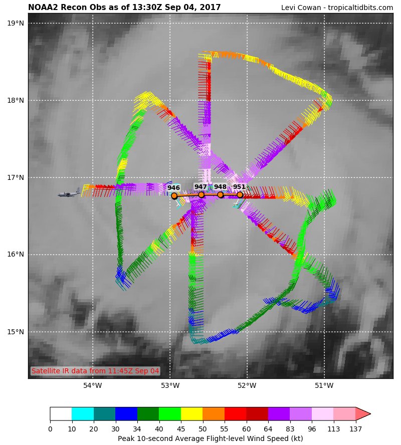
Vientos guiantes, 13 UTC.
Mi opinion...not good. Mi opinion, nada tiene que ver con la official, refiérase a NHC, NWS SJ para información official.

Mi opinion...not good. Mi opinion, nada tiene que ver con la official, refiérase a NHC, NWS SJ para información official.
-
StormWatch
- Cat. 3
- Posts: 3755
- Joined: Thu Aug 06, 2015 11:39 am
- Location: Texas, USA
Re: Huracan Irma - Categoría 3
Vía Twitter CycloforumsPR
Importante DATO:
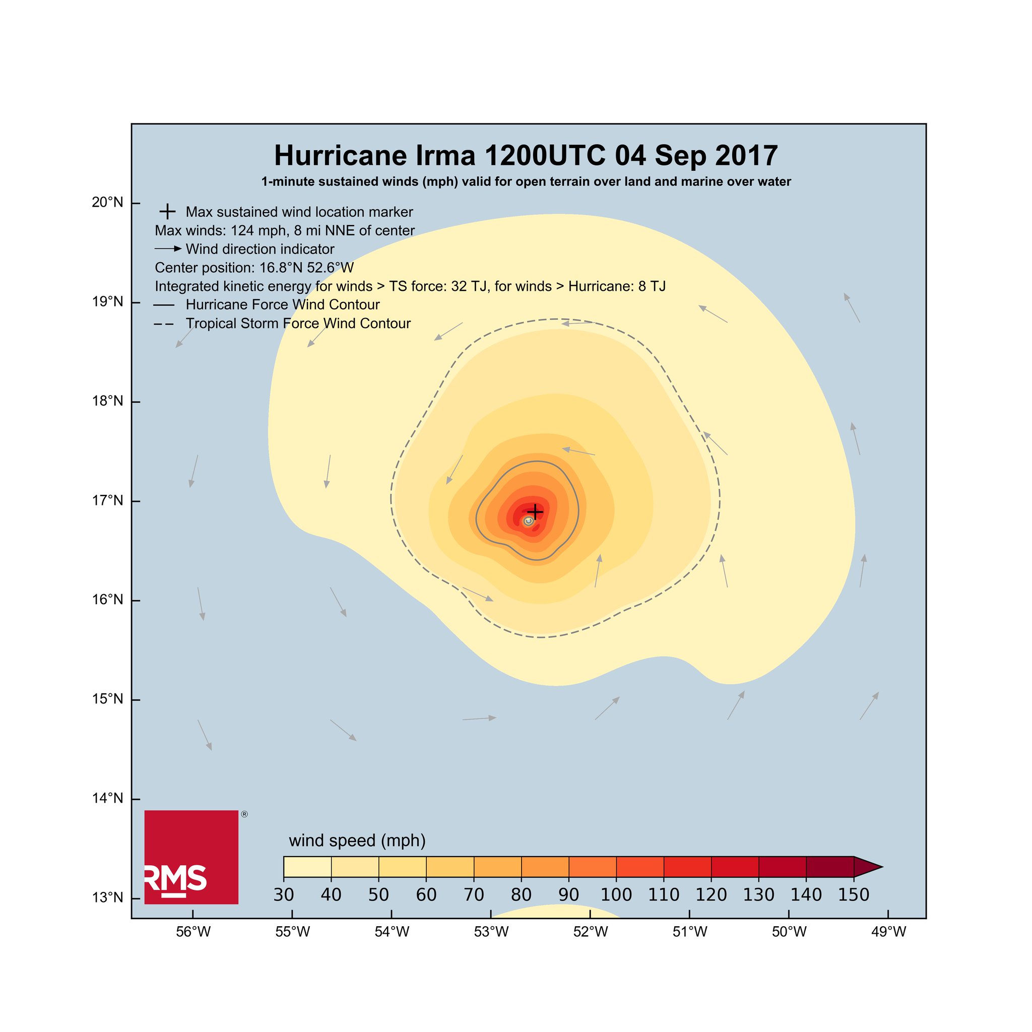
Análisis privado del campo de vientos de #Irma asemeja en tamaño e intensidad a Harvey.
Importante DATO:
Análisis privado del campo de vientos de #Irma asemeja en tamaño e intensidad a Harvey.
Member Since 2005
For official information, please refer to NHC: https://www.nhc.noaa.gov
Hurricane’s hit Puerto Rico:
San Felipe 1928, San Ciprián 1932, Santa Clara 1956, Hugo 1989, Marilyn 1995, Hortense 1996, Georges 1998, Maria 2017, Fiona 2022
Model Runs:
GFS:
[5:30 AM/PM, 11:30 AM/PM]
HWRF, GFDL, UKMET, NAVGEM:
[6:30-8:00 AM/PM, 12:30-2:00 AM/PM]
ECMWF:
[1:45 AM/PM]
For official information, please refer to NHC: https://www.nhc.noaa.gov
Hurricane’s hit Puerto Rico:
San Felipe 1928, San Ciprián 1932, Santa Clara 1956, Hugo 1989, Marilyn 1995, Hortense 1996, Georges 1998, Maria 2017, Fiona 2022
Model Runs:
GFS:
[5:30 AM/PM, 11:30 AM/PM]
HWRF, GFDL, UKMET, NAVGEM:
[6:30-8:00 AM/PM, 12:30-2:00 AM/PM]
ECMWF:
[1:45 AM/PM]
-
StormWatch
- Cat. 3
- Posts: 3755
- Joined: Thu Aug 06, 2015 11:39 am
- Location: Texas, USA
Re: Huracan Irma - Categoría 3
Vía Twitter CycloforumsPR
Radar muestra doble pared en el ojo de #Irma, señal de q podría crecer en tamaño. Eso no sería bueno dada la trayectoria cerca de PR.
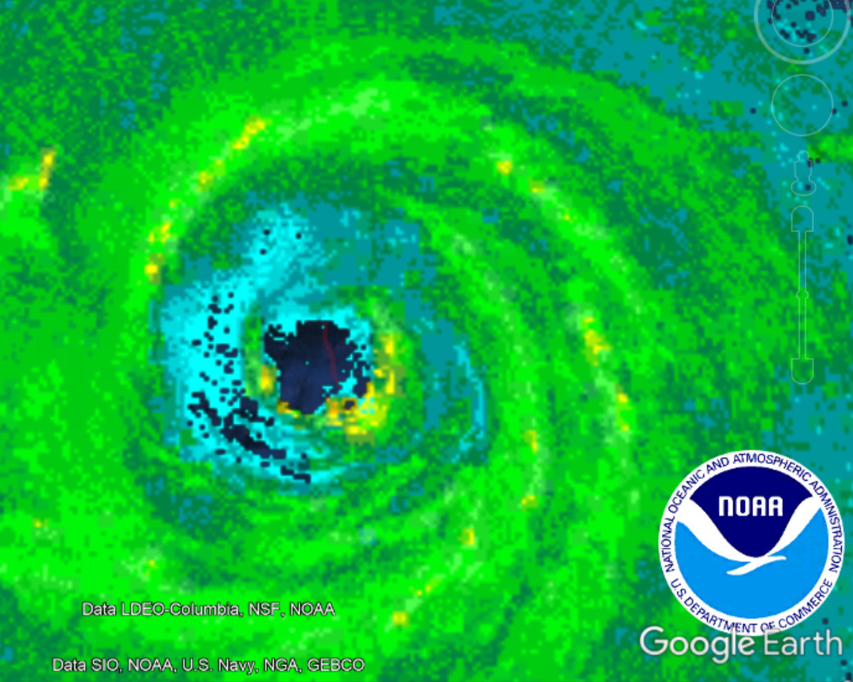

Radar muestra doble pared en el ojo de #Irma, señal de q podría crecer en tamaño. Eso no sería bueno dada la trayectoria cerca de PR.
Member Since 2005
For official information, please refer to NHC: https://www.nhc.noaa.gov
Hurricane’s hit Puerto Rico:
San Felipe 1928, San Ciprián 1932, Santa Clara 1956, Hugo 1989, Marilyn 1995, Hortense 1996, Georges 1998, Maria 2017, Fiona 2022
Model Runs:
GFS:
[5:30 AM/PM, 11:30 AM/PM]
HWRF, GFDL, UKMET, NAVGEM:
[6:30-8:00 AM/PM, 12:30-2:00 AM/PM]
ECMWF:
[1:45 AM/PM]
For official information, please refer to NHC: https://www.nhc.noaa.gov
Hurricane’s hit Puerto Rico:
San Felipe 1928, San Ciprián 1932, Santa Clara 1956, Hugo 1989, Marilyn 1995, Hortense 1996, Georges 1998, Maria 2017, Fiona 2022
Model Runs:
GFS:
[5:30 AM/PM, 11:30 AM/PM]
HWRF, GFDL, UKMET, NAVGEM:
[6:30-8:00 AM/PM, 12:30-2:00 AM/PM]
ECMWF:
[1:45 AM/PM]
-
StormWatch
- Cat. 3
- Posts: 3755
- Joined: Thu Aug 06, 2015 11:39 am
- Location: Texas, USA
Re: Huracan Irma - Categoría 3
ATENCIÓN: CNH y @NWSSanJuan emiten vigilancia de huracán para Puerto Rico.
Member Since 2005
For official information, please refer to NHC: https://www.nhc.noaa.gov
Hurricane’s hit Puerto Rico:
San Felipe 1928, San Ciprián 1932, Santa Clara 1956, Hugo 1989, Marilyn 1995, Hortense 1996, Georges 1998, Maria 2017, Fiona 2022
Model Runs:
GFS:
[5:30 AM/PM, 11:30 AM/PM]
HWRF, GFDL, UKMET, NAVGEM:
[6:30-8:00 AM/PM, 12:30-2:00 AM/PM]
ECMWF:
[1:45 AM/PM]
For official information, please refer to NHC: https://www.nhc.noaa.gov
Hurricane’s hit Puerto Rico:
San Felipe 1928, San Ciprián 1932, Santa Clara 1956, Hugo 1989, Marilyn 1995, Hortense 1996, Georges 1998, Maria 2017, Fiona 2022
Model Runs:
GFS:
[5:30 AM/PM, 11:30 AM/PM]
HWRF, GFDL, UKMET, NAVGEM:
[6:30-8:00 AM/PM, 12:30-2:00 AM/PM]
ECMWF:
[1:45 AM/PM]

Re: Huracan Irma - Categoría 3
BULLETIN
Hurricane Irma Advisory Number 21
NWS National Hurricane Center Miami FL AL112017
1100 AM AST Mon Sep 04 2017
...HURRICANE WARNINGS ISSUED FOR PORTIONS OF THE LEEWARD ISLANDS...
...HURRICANE WATCHES ISSUED FOR THE BRITISH AND U.S. VIRGIN ISLANDS
AND PUERTO RICO...
SUMMARY OF 1100 AM AST...1500 UTC...INFORMATION
-----------------------------------------------
LOCATION...16.8N 53.3W
ABOUT 560 MI...905 KM E OF THE LEEWARD ISLANDS
MAXIMUM SUSTAINED WINDS...120 MPH...195 KM/H
PRESENT MOVEMENT...WSW OR 255 DEGREES AT 14 MPH...22 KM/H
MINIMUM CENTRAL PRESSURE...944 MB...27.88 INCHES
WATCHES AND WARNINGS
--------------------
CHANGES WITH THIS ADVISORY:
The government of Antigua has issued a Hurricane Warning for the
islands of Antigua, Barbuda, Anguilla, Montserrat, St. Kitts, and
Nevis. A Hurricane Watch has been issued for the British Virgin
Islands.
The government of the Netherlands has issued a Hurricane Warning for
the islands of Saba, St. Eustatius, and Sint Maarten.
The government of France has issued a Hurricane Warning for St.
Martin and Saint Barthelemy. A Hurricane Watch has been issued for
Guadeloupe.
A Hurricane Watch has been issued for the U.S. Virgin Islands,
Puerto Rico, Vieques, and Culebra.
The government of Barbados has issued a Tropical Storm Watch for
Dominica.
SUMMARY OF WATCHES AND WARNINGS IN EFFECT:
A Hurricane Warning is in effect for...
* Antigua, Barbuda, Anguilla, Montserrat, St. Kitts, and Nevis
* Saba, St. Eustatius, and Sint Maarten
* Saint Martin and Saint Barthelemy
A Hurricane Watch is in effect for...
* Guadeloupe
* British Virgin Islands
* U.S. Virgin Islands
* Puerto Rico, Vieques, and Culebra
A Tropical Storm Watch is in effect for...
* Dominica
A Hurricane Warning means that hurricane conditions are expected
somewhere within the warning area. A warning is typically issued
36 hours before the anticipated first occurrence of tropical-storm-
force winds, conditions that make outside preparations difficult or
dangerous. Preparations to protect life and property should be
rushed to completion.
A Hurricane Watch means that hurricane conditions are possible
within the watch area. A watch is typically issued 48 hours before
the anticipated first occurrence of tropical-storm-force winds,
conditions that make outside preparations difficult or dangerous.
A Tropical Storm Watch means that tropical storm conditions are
possible within the watch area, generally within 48 hours.
Interests in the Dominican Republic, Haiti, the Turks and Caicos
Islands, and the southeastern Bahamas should monitor the progress of
Irma.
For storm information specific to your area in the United States,
including possible inland watches and warnings, please monitor
products issued by your local National Weather Service forecast
office. For storm information specific to your area outside the
United States, please monitor products issued by your national
meteorological service.
DISCUSSION AND 48-HOUR OUTLOOK
------------------------------
At 1100 AM AST (1500 UTC), the eye of Hurricane Irma was located
near latitude 16.8 North, longitude 53.3 West. Irma is moving toward
the west-southwest near 14 mph (22 km/h). A turn toward the west
is expected later today, followed by a west-northwestward turn late
Tuesday. On the forecast track, the center of Irma will move near
or over portions of the northern Leeward Islands Tuesday night
and early Wednesday.
Maximum sustained winds are near 120 mph (195 km/h) with higher
gusts. Irma is a category 3 hurricane on the Saffir-Simpson
Hurricane Wind Scale. Additional strengthening is forecast through
Tuesday night.
Hurricane-force winds extend outward up to 35 miles (55 km) from the
center and tropical-storm-force winds extend outward up to 140 miles
(220 km).
The estimated minimum central pressure based on data from a NOAA
Hurricane Hunter aircraft is 944 mb (27.88 inches).
HAZARDS AFFECTING LAND
----------------------
STORM SURGE: The combination of a dangerous storm surge and large
breaking waves will raise water levels by as much as 6 to 9 feet
above normal tide levels along the coasts of the extreme northern
Leeward Islands within the hurricane warning area near and to the
north of the center of Irma. Near the coast, the surge will be
accompanied by large and destructive waves.
WIND: Hurricane conditions are expected within the hurricane
warning area by Tuesday night, with tropical storm conditions
expected by late Tuesday. Hurricane conditions are possible within
the hurricane watch area by late Wednesday, with tropical storm
conditions possible by early Wednesday.
RAINFALL: Irma is expected to produce total rainfall accumulations
of 3 to 6 inches across the Leeward Islands, with isolated maximum
amounts of 10 inches across the northern Leeward Islands. These
rainfall amounts may cause life-threatening flash floods and
mudslides.
SURF: Swells generated by Irma will affect the northern Leeward
Islands during the next several days. These swells are likely to
cause life-threatening surf and rip current conditions. Please
consult products from your local weather office.
NEXT ADVISORY
-------------
Next intermediate advisory at 200 PM AST.
Next complete advisory at 500 PM AST.
$$
Forecaster Brown
emh- huracan es simplemente ahora Edgardo. Importante: Phil Klotzbach, recordó que "el mejor momento para prepararse para los huracanes es cuando todavía no hay huracanes".