

Huracán Matthew
-
StormWatch
- Cat. 3

- Posts: 3755
- Joined: Thu Aug 06, 2015 11:39 am
- Location: Texas, USA
Re: Huracán Matthew
Member Since 2005
For official information, please refer to NHC: https://www.nhc.noaa.gov
Hurricane’s hit Puerto Rico:
San Felipe 1928, San Ciprián 1932, Santa Clara 1956, Hugo 1989, Marilyn 1995, Hortense 1996, Georges 1998, Maria 2017, Fiona 2022
Model Runs:
GFS:
[5:30 AM/PM, 11:30 AM/PM]
HWRF, GFDL, UKMET, NAVGEM:
[6:30-8:00 AM/PM, 12:30-2:00 AM/PM]
ECMWF:
[1:45 AM/PM]
-
StormWatch
- Cat. 3
- Posts: 3755
- Joined: Thu Aug 06, 2015 11:39 am
- Location: Texas, USA
Re: Huracán Matthew
8pm
ZCZC MIATCPAT4 ALL
TTAA00 KNHC DDHHMM
BULLETIN
HURRICANE MATTHEW INTERMEDIATE ADVISORY NUMBER 23A
NWS NATIONAL HURRICANE CENTER MIAMI FL AL142016
800 PM EDT MON OCT 03 2016
...HURRICANE HUNTERS FIND MATTHEW IS STILL A 140-MPH HURRICANE...
...LIFE-THREATENING RAIN...WIND...AND STORM SURGE EXPECTED IN
PARTS OF HAITI TONIGHT...
SUMMARY OF 800 PM EDT...0000 UTC...INFORMATION
----------------------------------------------
LOCATION...16.6N 74.6W
ABOUT 120 MI...190 KM S OF TIBURON HAITI
ABOUT 200 MI...325 KM SW OF PORT AU PRINCE HAITI
MAXIMUM SUSTAINED WINDS...140 MPH...220 KM/H
PRESENT MOVEMENT...NNE OR 15 DEGREES AT 8 MPH...13 KM/H
MINIMUM CENTRAL PRESSURE...940 MB...27.76 INCHES
WATCHES AND WARNINGS
--------------------
CHANGES WITH THIS ADVISORY:
The government of the Bahamas has issued a Hurricane Warning for
the Central Bahamas, including Long Island, Exuma, Rum Cay, San
Salvador, and Cat Island, and a Hurricane Watch for the northwestern
Bahamas, including the Abacos, Andros Island, Berry Islands, Bimini,
Eleuthera, Grand Bahama Island, and New Providence.
SUMMARY OF WATCHES AND WARNINGS IN EFFECT:
A Hurricane Warning is in effect for...
* Haiti
* Cuban provinces of Guantanamo, Santiago de Cuba, Holguin, Granma,
and Las Tunas
* Southeastern Bahamas, including the Inaguas, Mayaguana, Acklins,
Crooked Island, Long Cay, and Ragged Island
* Central Bahamas, including Long Island, Exuma, Rum Cay, San
Salvador, and Cat Island
A Hurricane Watch is in effect for...
* Cuban province of Camaguey
* Turks and Caicos Islands
* Northwestern Bahamas, including the Abacos, Andros Island, Berry
Islands, Bimini, Eleuthera, Grand Bahama Island, and New Providence
A Tropical Storm Warning is in effect for...
* Dominican Republic from Barahona westward to the border with Haiti
* Jamaica
A Tropical Storm Watch is in effect for...
* Dominican Republic from Puerto Plata westward to the border with
Haiti
Interests elsewhere in Hispaniola, the Bahamas, and in the Florida
Peninsula and the Florida Keys should monitor the progress of
Matthew.
A Hurricane Warning means that hurricane conditions are expected
somewhere within the warning area. A warning is typically issued
36 hours before the anticipated first occurrence of tropical-storm-
force winds, conditions that make outside preparations difficult or
dangerous. Preparations to protect life and property should be
rushed to completion.
A Hurricane Watch means that hurricane conditions are possible
within the watch area. A watch is typically issued 48 hours
before the anticipated first occurrence of tropical-storm-force
winds, conditions that make outside preparations difficult or
dangerous.
For storm information specific to your area, please monitor
products issued by your national meteorological service.
DISCUSSION AND 48-HOUR OUTLOOK
------------------------------
At 800 PM EDT (0000 UTC), the eye of Hurricane Matthew was located
near latitude 16.6 North, longitude 74.6 West. Matthew is moving
toward the north-northeast near 8 mph (13 km/h). A turn back
toward the north at a faster forward speed is expected later tonight
through Tuesday night. A turn toward the north-northwest is forecast
on Wednesday. On the forecast track, the center of Matthew will
approach southwestern Haiti tonight, move near eastern Cuba late
Tuesday, and move near or over portions of the southeastern and
central Bahamas Tuesday night and Wednesday.
Maximum sustained winds remain near 140 mph (220 km/h) with higher
gusts. Matthew is a dangerous category 4 hurricane on the Saffir-
Simpson Hurricane Wind Scale. Some fluctuations in intensity are
possible during the next couple of days, but Matthew is expected to
remain a powerful hurricane through Wednesday.
Hurricane-force winds extend outward up to 40 miles (65 km) from
the center and tropical-storm-force winds extend outward up to 185
miles (295 km).
The estimated minimum central pressure is 940 mb (27.76 inches).
HAZARDS AFFECTING LAND
----------------------
WIND: Hurricane conditions are expected to first reach Haiti
tonight, eastern Cuba Tuesday, the southeastern Bahamas late
Tuesday, and the central Bahamas on Wednesday. Tropical storm
conditions are expected to continue spreading across Haiti this
evening, reach eastern Cuba tonight, the southeastern Bahamas early
Tuesday, and the central Bahamas Tuesday night, making outside
preparations difficult or dangerous. Preparations to protect life
and property should be rushed to completion.
Tropical storm conditions are expected in portions of Jamaica and
along the southern coast of the Dominican Republic within the
warning area soon.
Hurricane conditions are possible in the northwestern Bahamas on
Thursday, with tropical storm conditions possible on Wednesday.
Hurricane conditions are possible in the hurricane watch areas in
Cuba and the Turks and Caicos Islands by Tuesday night with tropical
storm conditions possible on Tuesday.
RAINFALL: Matthew is expected to produce total rainfall amounts in
the following areas:
Southern Haiti and southwestern Dominican Republic...15 to 25
inches, isolated 40 inches
Eastern Cuba and northwestern Haiti...8 to 12 inches, isolated
20 inches
Eastern Jamaica...5 to 10 inches, isolated 15 to 20 inches
The Bahamas...8 to 12 inches, isolated 15 inches
Turks and Caicos Islands...2 to 5 inches, isolated 8 inches
Northeastern Haiti and the Dominican Republic...1 to 3 inches,
isolated 5 inches
Western Jamaica...1 to 2 inches
Life-threatening flash floods and mudslides are likely from this
rainfall in southern and northwestern Haiti, the southwestern
Dominican Republic, and eastern Cuba.
STORM SURGE: The combination of a dangerous storm surge and large
and destructive waves could raise water levels by as much as the
following amounts above normal tide levels...
Southern Coast of Cuba east of Cabo Cruz...7 to 11 feet
South Coast of Haiti...7 to 10 feet
Northern Coast of Cuba east of Camaguey...4 to 6 feet
Jamaica...2 to 4 feet
Gulf of Gonave in Haiti...3 to 5 feet
Southern coast of the Dominican Republic...1 to 3 feet
The Bahamas...10 to 15 feet
Surge-related flooding depends on the relative timing of the surge
and the tidal cycle, and can vary greatly over short distances.
Large waves generated by Matthew will cause water rises to occur
well in advance of and well away from the track of the center.
SURF: Swells generated by Matthew will continue to affect portions
of the coasts of Hispaniola, Jamaica, Aruba, Colombia, eastern Cuba,
and the Caribbean coastline of Central America during the next few
days. Swells from Matthew will begin affecting portions of the
Bahamas on Tuesday. These swells are likely to cause life-
threatening surf and rip current conditions. Please consult
products from your local weather office.
NEXT ADVISORY
-------------
Next complete advisory at 1100 PM EDT.
$$
Forecaster Stewart
NNNN
Member Since 2005
For official information, please refer to NHC: https://www.nhc.noaa.gov
Hurricane’s hit Puerto Rico:
San Felipe 1928, San Ciprián 1932, Santa Clara 1956, Hugo 1989, Marilyn 1995, Hortense 1996, Georges 1998, Maria 2017, Fiona 2022
Model Runs:
GFS:
[5:30 AM/PM, 11:30 AM/PM]
HWRF, GFDL, UKMET, NAVGEM:
[6:30-8:00 AM/PM, 12:30-2:00 AM/PM]
ECMWF:
[1:45 AM/PM]
For official information, please refer to NHC: https://www.nhc.noaa.gov
Hurricane’s hit Puerto Rico:
San Felipe 1928, San Ciprián 1932, Santa Clara 1956, Hugo 1989, Marilyn 1995, Hortense 1996, Georges 1998, Maria 2017, Fiona 2022
Model Runs:
GFS:
[5:30 AM/PM, 11:30 AM/PM]
HWRF, GFDL, UKMET, NAVGEM:
[6:30-8:00 AM/PM, 12:30-2:00 AM/PM]
ECMWF:
[1:45 AM/PM]
-
Laniña2016
- Invest

- Posts: 212
- Joined: Sat May 28, 2016 7:19 am
Re: Huracán Matthew
NNE 8 mph


Last edited by Laniña2016 on Mon Oct 03, 2016 8:13 pm, edited 1 time in total.
-
StormWatch
- Cat. 3
- Posts: 3755
- Joined: Thu Aug 06, 2015 11:39 am
- Location: Texas, USA
Re: Huracán Matthew
At 8pm
LOCATION...16.6N 74.6W
WINDS...140 MPH
MOVEMENT...NNE OR 15 DEGREES AT 8 MPH
PRESSURE...940 MB

LOCATION...16.6N 74.6W
WINDS...140 MPH
MOVEMENT...NNE OR 15 DEGREES AT 8 MPH
PRESSURE...940 MB
Member Since 2005
For official information, please refer to NHC: https://www.nhc.noaa.gov
Hurricane’s hit Puerto Rico:
San Felipe 1928, San Ciprián 1932, Santa Clara 1956, Hugo 1989, Marilyn 1995, Hortense 1996, Georges 1998, Maria 2017, Fiona 2022
Model Runs:
GFS:
[5:30 AM/PM, 11:30 AM/PM]
HWRF, GFDL, UKMET, NAVGEM:
[6:30-8:00 AM/PM, 12:30-2:00 AM/PM]
ECMWF:
[1:45 AM/PM]
For official information, please refer to NHC: https://www.nhc.noaa.gov
Hurricane’s hit Puerto Rico:
San Felipe 1928, San Ciprián 1932, Santa Clara 1956, Hugo 1989, Marilyn 1995, Hortense 1996, Georges 1998, Maria 2017, Fiona 2022
Model Runs:
GFS:
[5:30 AM/PM, 11:30 AM/PM]
HWRF, GFDL, UKMET, NAVGEM:
[6:30-8:00 AM/PM, 12:30-2:00 AM/PM]
ECMWF:
[1:45 AM/PM]
-
StormWatch
- Cat. 3
- Posts: 3755
- Joined: Thu Aug 06, 2015 11:39 am
- Location: Texas, USA
Re: Huracán Matthew
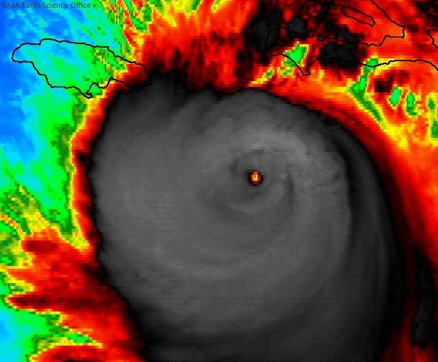
OOOMMMMGGGGGGGGGGGGGG! 
Member Since 2005
For official information, please refer to NHC: https://www.nhc.noaa.gov
Hurricane’s hit Puerto Rico:
San Felipe 1928, San Ciprián 1932, Santa Clara 1956, Hugo 1989, Marilyn 1995, Hortense 1996, Georges 1998, Maria 2017, Fiona 2022
Model Runs:
GFS:
[5:30 AM/PM, 11:30 AM/PM]
HWRF, GFDL, UKMET, NAVGEM:
[6:30-8:00 AM/PM, 12:30-2:00 AM/PM]
ECMWF:
[1:45 AM/PM]
For official information, please refer to NHC: https://www.nhc.noaa.gov
Hurricane’s hit Puerto Rico:
San Felipe 1928, San Ciprián 1932, Santa Clara 1956, Hugo 1989, Marilyn 1995, Hortense 1996, Georges 1998, Maria 2017, Fiona 2022
Model Runs:
GFS:
[5:30 AM/PM, 11:30 AM/PM]
HWRF, GFDL, UKMET, NAVGEM:
[6:30-8:00 AM/PM, 12:30-2:00 AM/PM]
ECMWF:
[1:45 AM/PM]
-
StormWatch
- Cat. 3
- Posts: 3755
- Joined: Thu Aug 06, 2015 11:39 am
- Location: Texas, USA
Re: Huracán Matthew
Mas cerca!
Via Twitter!
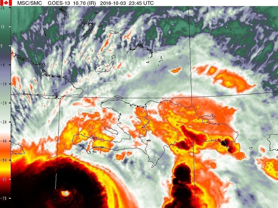
Via Twitter!
Member Since 2005
For official information, please refer to NHC: https://www.nhc.noaa.gov
Hurricane’s hit Puerto Rico:
San Felipe 1928, San Ciprián 1932, Santa Clara 1956, Hugo 1989, Marilyn 1995, Hortense 1996, Georges 1998, Maria 2017, Fiona 2022
Model Runs:
GFS:
[5:30 AM/PM, 11:30 AM/PM]
HWRF, GFDL, UKMET, NAVGEM:
[6:30-8:00 AM/PM, 12:30-2:00 AM/PM]
ECMWF:
[1:45 AM/PM]
For official information, please refer to NHC: https://www.nhc.noaa.gov
Hurricane’s hit Puerto Rico:
San Felipe 1928, San Ciprián 1932, Santa Clara 1956, Hugo 1989, Marilyn 1995, Hortense 1996, Georges 1998, Maria 2017, Fiona 2022
Model Runs:
GFS:
[5:30 AM/PM, 11:30 AM/PM]
HWRF, GFDL, UKMET, NAVGEM:
[6:30-8:00 AM/PM, 12:30-2:00 AM/PM]
ECMWF:
[1:45 AM/PM]
-
StormWatch
- Cat. 3
- Posts: 3755
- Joined: Thu Aug 06, 2015 11:39 am
- Location: Texas, USA
Re: Huracán Matthew

Member Since 2005
For official information, please refer to NHC: https://www.nhc.noaa.gov
Hurricane’s hit Puerto Rico:
San Felipe 1928, San Ciprián 1932, Santa Clara 1956, Hugo 1989, Marilyn 1995, Hortense 1996, Georges 1998, Maria 2017, Fiona 2022
Model Runs:
GFS:
[5:30 AM/PM, 11:30 AM/PM]
HWRF, GFDL, UKMET, NAVGEM:
[6:30-8:00 AM/PM, 12:30-2:00 AM/PM]
ECMWF:
[1:45 AM/PM]
For official information, please refer to NHC: https://www.nhc.noaa.gov
Hurricane’s hit Puerto Rico:
San Felipe 1928, San Ciprián 1932, Santa Clara 1956, Hugo 1989, Marilyn 1995, Hortense 1996, Georges 1998, Maria 2017, Fiona 2022
Model Runs:
GFS:
[5:30 AM/PM, 11:30 AM/PM]
HWRF, GFDL, UKMET, NAVGEM:
[6:30-8:00 AM/PM, 12:30-2:00 AM/PM]
ECMWF:
[1:45 AM/PM]

Re: Huracán Matthew
Wow, tomando seriedad y dejando a un lado mi nombre de Vaguada, ciertamente me inundó un sentido de tristeza esas últimas imágenes de este huracán. Solo pensar lo que nuestros hermanos ya deben de haber comenzado a sentir me aflige. Deberá ser una experiencia aterradora máximo al tener un impacto a estas horas de la noche e imaginándome aquellos más lejos de la ciudad y que ignoran el grado del peligro que se les avecina. Solo le pido a Dios su misericordia y protección para todos ellos y a su vez le doy gracias por su infinita bendición sobre esta hermosa isla. A pesar de ser un aficionado de la meteorología realmente no sé si me gustaría estar en una posición de recibir un golpe como este. De todo corazon Dios los proteja y que surja un miragro para mañana y no se pierdan vidas ni tampoco se pierda sus pocas pertenencias. Me retiro realmente afligido!!
Las vaguadas no somos tan malas como algunos creen 
-
StormWatch
- Cat. 3
- Posts: 3755
- Joined: Thu Aug 06, 2015 11:39 am
- Location: Texas, USA
Re: Huracán Matthew
Catastrofica la lluvia q se espera!
#PrayForHaiti

#PrayForHaiti
Member Since 2005
For official information, please refer to NHC: https://www.nhc.noaa.gov
Hurricane’s hit Puerto Rico:
San Felipe 1928, San Ciprián 1932, Santa Clara 1956, Hugo 1989, Marilyn 1995, Hortense 1996, Georges 1998, Maria 2017, Fiona 2022
Model Runs:
GFS:
[5:30 AM/PM, 11:30 AM/PM]
HWRF, GFDL, UKMET, NAVGEM:
[6:30-8:00 AM/PM, 12:30-2:00 AM/PM]
ECMWF:
[1:45 AM/PM]
For official information, please refer to NHC: https://www.nhc.noaa.gov
Hurricane’s hit Puerto Rico:
San Felipe 1928, San Ciprián 1932, Santa Clara 1956, Hugo 1989, Marilyn 1995, Hortense 1996, Georges 1998, Maria 2017, Fiona 2022
Model Runs:
GFS:
[5:30 AM/PM, 11:30 AM/PM]
HWRF, GFDL, UKMET, NAVGEM:
[6:30-8:00 AM/PM, 12:30-2:00 AM/PM]
ECMWF:
[1:45 AM/PM]

Re: Huracán Matthew
Me uno a tus buenos pensamientos y oraciones Vaguada, y a las de todos lo demas que igualmente se han expresado.
Esta estacion del tiempo, muy cerca de donde entrata el centro ya esta reportando vientos sostenidos de 85MPH y rafagas de 111MPH
https://www.wunderground.com/ht//les-ca ... 00.1.78447
Esta estacion del tiempo, muy cerca de donde entrata el centro ya esta reportando vientos sostenidos de 85MPH y rafagas de 111MPH
https://www.wunderground.com/ht//les-ca ... 00.1.78447