David.79 wrote:StormWatch wrote:No posteare ningun modelo!
NO VEN absolutamente NADA!
Igual q el 99L
Bahhhhhhhhhhhhhhhhhhhhhh!!


Saludos David79 y demas foristas:
Yo ando mas o menos asi, pero no por el Invest92. A ese ya mas o menos veo por donde quiere ir.

Lo mio es a causa de los libros electronicos. Llevo horas en uno. A veces prefiero el "hard copy".
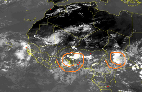
Del sistema, mas arriba dije algo que parece acorde con el ultimo TWO. Ese 0-50 tanto tiempo y velocidad se parece a desarrollo no tan rapido o al menos no en menos de tres dias. Y mas ahora con el ultimo TWO de las 2 AM del NHC en Miami:
"TROPICAL WEATHER OUTLOOK
NWS NATIONAL HURRICANE CENTER MIAMI FL
200 AM EDT TUE AUG 30 2016
For the North Atlantic...Caribbean Sea and the Gulf of Mexico:
The National Hurricane Center is issuing advisories on Hurricane
Gaston, located well east of Bermuda, on Tropical Depression Eight,
located southeast of Cape Hatteras, North Carolina, and on Tropical
Depression Nine, located over the southeastern Gulf of Mexico.
A weak area of low pressure, associated with a tropical wave, is
located over the far eastern Atlantic between the west coast of
Africa and the Cabo Verde Islands. Environmental conditions are
expected to become a little more favorable for some gradual
development of this system late this week while it moves
westward at 15 to 20 mph over the tropical Atlantic.
* Formation chance through 48 hours...low...near 0 percent
* Formation chance through 5 days...medium...40 percent
Forecaster Brown"
Ojala nunca llegue a esas categorias que inicialmente se ven en esos modelos. Prohibido un Cat 2 o mas en PR y en ningun lado. Si nos pasa por encima un Cat, 2 o mas, entonces si nos vamos por el abismo fiscal y mucho mas con lo mal que anda la infraestructura aqui.