

11:00 PM AST Sun Jun 30
Location: 11.5°N 58.1°W
Moving: W at 20 mph
Min pressure: 959 mb
Max sustained: 130 mph
000
WTNT42 KNHC 010244
TCDAT2
Hurricane Beryl Discussion Number 10
NWS National Hurricane Center Miami FL AL022024
1100 PM AST Sun Jun 30 2024
There are a few pieces of evidence that show that Beryl is in the
middle of an eyewall replacement cycle (ERC). The clear eye seen on
infrared satellite earlier today has become a little more clouded
over during the past few hours. In addition, data from the last leg
through Beryl from both the Air Force Reserve and NOAA Hurricane
Hunters indicated concentric eyewalls, which also matches current
radar imagery we are receiving from Barbados Meteorological Service.
An earlier SSMIS microwave pass at 2150 UTC also showed a formative
outer moat forming outside the small inner eyewall. In response to
the evolving structure, 700-mb flight-level winds from the NOAA and
Air Force planes are a little lower than observed earlier today, and
the latest round of Dvorak estimates also support a slightly lower
intensity. However, the initial intensity will remain at 115 kt for
this advisory, given a couple of dropsonde observations in the NE
quadrant of Beryl's inner eyewall.
Aircraft fixes indicate Beryl continues to move quickly westward
at 280/17 kt. There isn't much change with the track forecast
philosophy, as a extensive mid-level ridge poleward of Beryl should
maintain its westward to west-northwest motion for the next few days
as it move through the Windward Islands and into the eastern
Caribbean Sea. The ridge does become positioned more northwest of
Beryl towards the end of the forecast period, potentially allowing
the hurricane to slow down gradually once it reaches the
northwestern Caribbean Sea. The track guidance this cycle is quite
similar to the previous cycle, and thus the latest NHC track
forecast is also quite similar to the prior advisory.
Given the evolution to Beryl's inner core structure tonight due to
the aforementioned ERC, it would not be surprising to see a
short-term fluctuation down in Beryl's peak winds, though Beryl is
expected to remain a dangerous major hurricane as it crosses through
the Windward Islands tomorrow morning. In fact, there could also be
a bit of restrengthening after the ERC completes in the northwestern
Caribbean, and that is reflected in the short-term forecast. After
48 hours, a subtle upper-level trough to Beryl's north could induce
a bit more westerly vertical wind shear over the hurricane, and some
gradual weakening continues to be shown after 48 hours. However, it
should be emphasized that Beryl is forecast to remain a significant
hurricane during its entire trek across the Caribbean region, though
more prominent weakening is likely if Beryl crosses the Yucatan
between days 4-5 as shown in the latest forecast. The NHC intensity
forecast remains in good agreement with the consensus aids, and is
only slightly adjusted from the prior advisory.
Key Messages:
1. Beryl is expected to remain an extremely dangerous major
hurricane when it reaches the Windward Islands tomorrow morning.
This is a very dangerous situation and residents in these areas
should listen to local government and emergency management officials
for any preparedness and/or evacuation orders. These preparations
should have been completed today as significant impacts will begin
tomorrow morning.
2. Potentially catastrophic hurricane-force winds, a life-
threatening storm surge, and damaging waves are expected when Beryl
passes over portions of the Windward Islands with the highest risk
of the core in St. Vincent and the Grenadines, and Grenada
beginning early Monday morning. Hurricane Warnings are in effect
for much of the Windward Islands.
3. Heavy rainfall and localized flooding are expected across the
Windward Islands through Monday.
4. Beryl is expected to remain a powerful hurricane as it moves
across the Caribbean Sea later this week. A Tropical Storm Watch is
in effect for portions of the southern coast of the Dominican
Republic and Haiti. Interests elsewhere in Hispaniola, Jamaica, the
Cayman Islands, and the remainder of the northwestern Caribbean
should monitor its progress and additional Watches and Warnings will
likely be required this week.
FORECAST POSITIONS AND MAX WINDS
INIT 01/0300Z 11.5N 58.1W 115 KT 130 MPH
12H 01/1200Z 12.2N 60.7W 115 KT 130 MPH
24H 02/0000Z 13.4N 64.2W 120 KT 140 MPH
36H 02/1200Z 14.8N 68.0W 115 KT 130 MPH
48H 03/0000Z 15.9N 72.0W 105 KT 120 MPH
60H 03/1200Z 16.7N 75.8W 95 KT 110 MPH
72H 04/0000Z 17.6N 79.5W 90 KT 105 MPH
96H 05/0000Z 19.0N 85.9W 85 KT 100 MPH
120H 06/0000Z 20.7N 91.5W 55 KT 65 MPH...OVER WATER
$$
Forecaster Papin
Huracán Beryl entrando al oeste del Mar Caribe
Re: Huracán Beryl rumbo al Caribe
11:10 AM AST Mon Jul 1
Location: 12.5°N 61.5°W
Moving: WNW at 20 mph
Min pressure: 950 mb
Max sustained: 150 mph
000
WTNT42 KNHC 011457
TCDAT2
Hurricane Beryl Discussion Number 12
NWS National Hurricane Center Miami FL AL022024
1100 AM AST Mon Jul 01 2024
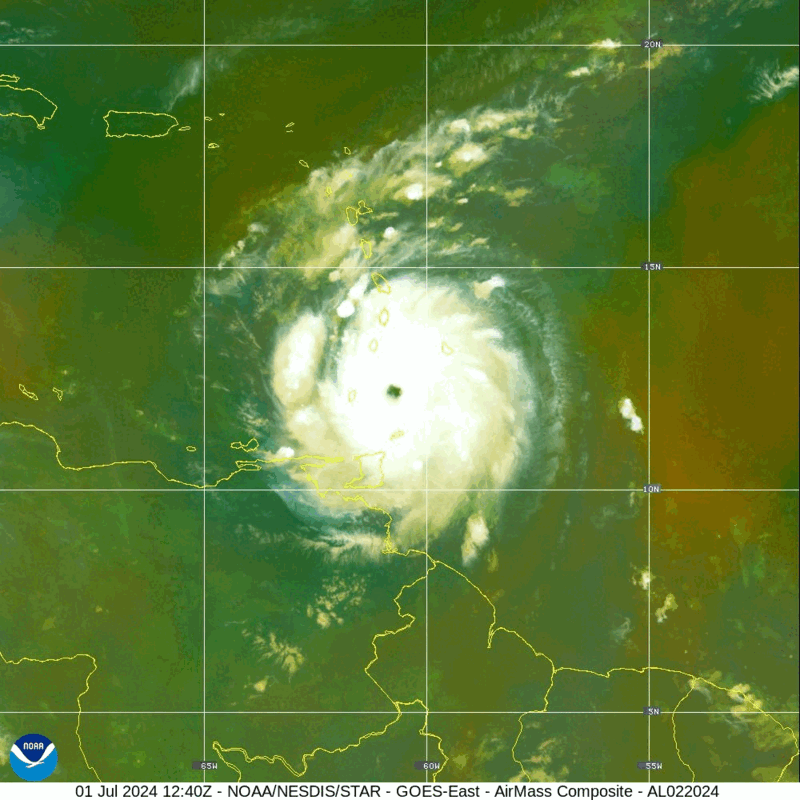
Satellite and radar data this morning suggest Beryl has completed an
eyewall replacement cycle. Radar images from Barbados show a solid
ring of deep convection surrounding the warming, well-defined eye of
the hurricane. Data collected by the NOAA and Air Force Hurricane
Hunters this morning confirm that Beryl has strengthened. Dropsondes
indicate the central pressure has fallen to around 956 mb, and the
earlier flight-level winds and SFMR data supported an intensity of
around 115 kt a couple of hours ago. The hurricane's satellite
structure has continued to improve this morning, and recent
objective satellite estimates justify raising the initial intensity
to 120 kt. The core of the powerful hurricane is nearing Carriacou
Island, Grenada, and the Grenadine Islands, where conditions are
rapidly deteriorating and residents should take action to protect
their lives.
Aircraft and radar fixes indicate Beryl has jogged northwestward
over the past several hours, and the initial estimated motion is
west-northwest or 285/17 kt. The hurricane is currently moving
across the southern Windward Islands. A mid-level steering ridge to
the north of Beryl should steer the hurricane quickly
west-northwestward to westward across the Caribbean Sea during the
next few days as a mid-level ridge strengthens to the north of the
cyclone. This portion of the track forecast is very similar to the
previous advisory, and the NHC forecast remains close to the
multi-model consensus aids. At days 3-5, there is some increased
spread in the track guidance, likely regarding the strength of the
steering ridge as Beryl approaches the northwestern Caribbean Sea
and the Yucatan Peninsula. This portion of the forecast was nudged
slightly north of the previous one, but still lies south of the
consensus aids.
Since the eyewall replacement cycle has completed, the updated NHC
forecast allows for some additional near-term strengthening based on
recent aircraft data and the improved satellite and radar structure
of the hurricane. As previously noted, an increase in westerly shear
is expected by midweek, which is expected to induce some weakening
while Beryl moves across the central and northwestern Caribbean Sea.
This is reflected in the latest NHC prediction that follows the
multi-model consensus trends. Regardless, Beryl is forecast to
remain a powerful hurricane through late this week, and interests in
the northwestern Caribbean and the Yucatan Peninsula should continue
to monitor the latest forecast updates.
Based on the latest NHC forecast, the government of Jamaica has
issued a Hurricane Watch for the island.
Key Messages:
1. The eyewall of Beryl is moving through the southern Windward
Islands. This is an extremely dangerous and life-threatening
situation. Take action now to protect your life! Residents in
Grenada, the Grenadine Islands, and Carriacou Island should not
leave their shelter as destructive winds and life-threatening storm
surge are expected during the next few hours. Shelter in place
through the passage of these life-threatening conditions and do not
venture out in the eye of the storm.
2. Heavy rainfall and localized flash flooding are expected across
the Windward Islands through this afternoon.
3. Beryl is expected to remain a powerful hurricane as it moves
across the Caribbean Sea later this week. A Hurricane Watch has been
issued for Jamaica. Interests in the Cayman Islands, Belize, the
Yucatan Peninsula, and the remainder of the northwestern Caribbean
should monitor its progress. Additional watches and warnings will
likely be required during the next day or two.
FORECAST POSITIONS AND MAX WINDS
INIT 01/1500Z 12.4N 61.3W 120 KT 140 MPH
12H 02/0000Z 13.3N 64.1W 125 KT 145 MPH
24H 02/1200Z 14.5N 67.8W 125 KT 145 MPH
36H 03/0000Z 15.6N 71.7W 110 KT 125 MPH
48H 03/1200Z 16.4N 75.6W 95 KT 110 MPH
60H 04/0000Z 17.2N 79.2W 90 KT 105 MPH
72H 04/1200Z 17.8N 82.6W 80 KT 90 MPH
96H 05/1200Z 19.0N 88.5W 65 KT 75 MPH...INLAND
120H 06/1200Z 20.5N 93.0W 55 KT 65 MPH...OVER WATER
$$
Forecaster Reinhart
Location: 12.5°N 61.5°W
Moving: WNW at 20 mph
Min pressure: 950 mb
Max sustained: 150 mph
000
WTNT42 KNHC 011457
TCDAT2
Hurricane Beryl Discussion Number 12
NWS National Hurricane Center Miami FL AL022024
1100 AM AST Mon Jul 01 2024
Satellite and radar data this morning suggest Beryl has completed an
eyewall replacement cycle. Radar images from Barbados show a solid
ring of deep convection surrounding the warming, well-defined eye of
the hurricane. Data collected by the NOAA and Air Force Hurricane
Hunters this morning confirm that Beryl has strengthened. Dropsondes
indicate the central pressure has fallen to around 956 mb, and the
earlier flight-level winds and SFMR data supported an intensity of
around 115 kt a couple of hours ago. The hurricane's satellite
structure has continued to improve this morning, and recent
objective satellite estimates justify raising the initial intensity
to 120 kt. The core of the powerful hurricane is nearing Carriacou
Island, Grenada, and the Grenadine Islands, where conditions are
rapidly deteriorating and residents should take action to protect
their lives.
Aircraft and radar fixes indicate Beryl has jogged northwestward
over the past several hours, and the initial estimated motion is
west-northwest or 285/17 kt. The hurricane is currently moving
across the southern Windward Islands. A mid-level steering ridge to
the north of Beryl should steer the hurricane quickly
west-northwestward to westward across the Caribbean Sea during the
next few days as a mid-level ridge strengthens to the north of the
cyclone. This portion of the track forecast is very similar to the
previous advisory, and the NHC forecast remains close to the
multi-model consensus aids. At days 3-5, there is some increased
spread in the track guidance, likely regarding the strength of the
steering ridge as Beryl approaches the northwestern Caribbean Sea
and the Yucatan Peninsula. This portion of the forecast was nudged
slightly north of the previous one, but still lies south of the
consensus aids.
Since the eyewall replacement cycle has completed, the updated NHC
forecast allows for some additional near-term strengthening based on
recent aircraft data and the improved satellite and radar structure
of the hurricane. As previously noted, an increase in westerly shear
is expected by midweek, which is expected to induce some weakening
while Beryl moves across the central and northwestern Caribbean Sea.
This is reflected in the latest NHC prediction that follows the
multi-model consensus trends. Regardless, Beryl is forecast to
remain a powerful hurricane through late this week, and interests in
the northwestern Caribbean and the Yucatan Peninsula should continue
to monitor the latest forecast updates.
Based on the latest NHC forecast, the government of Jamaica has
issued a Hurricane Watch for the island.
Key Messages:
1. The eyewall of Beryl is moving through the southern Windward
Islands. This is an extremely dangerous and life-threatening
situation. Take action now to protect your life! Residents in
Grenada, the Grenadine Islands, and Carriacou Island should not
leave their shelter as destructive winds and life-threatening storm
surge are expected during the next few hours. Shelter in place
through the passage of these life-threatening conditions and do not
venture out in the eye of the storm.
2. Heavy rainfall and localized flash flooding are expected across
the Windward Islands through this afternoon.
3. Beryl is expected to remain a powerful hurricane as it moves
across the Caribbean Sea later this week. A Hurricane Watch has been
issued for Jamaica. Interests in the Cayman Islands, Belize, the
Yucatan Peninsula, and the remainder of the northwestern Caribbean
should monitor its progress. Additional watches and warnings will
likely be required during the next day or two.
FORECAST POSITIONS AND MAX WINDS
INIT 01/1500Z 12.4N 61.3W 120 KT 140 MPH
12H 02/0000Z 13.3N 64.1W 125 KT 145 MPH
24H 02/1200Z 14.5N 67.8W 125 KT 145 MPH
36H 03/0000Z 15.6N 71.7W 110 KT 125 MPH
48H 03/1200Z 16.4N 75.6W 95 KT 110 MPH
60H 04/0000Z 17.2N 79.2W 90 KT 105 MPH
72H 04/1200Z 17.8N 82.6W 80 KT 90 MPH
96H 05/1200Z 19.0N 88.5W 65 KT 75 MPH...INLAND
120H 06/1200Z 20.5N 93.0W 55 KT 65 MPH...OVER WATER
$$
Forecaster Reinhart
Re: Huracán Beryl rumbo al Caribe
Subió a 150mph Beryl,
11:10 AM AST Mon Jul 1
Location: 12.5°N 61.5°W
Moving: WNW at 20 mph
Min pressure: 950 mb
Max sustained: 150 mph

11:10 AM AST Mon Jul 1
Location: 12.5°N 61.5°W
Moving: WNW at 20 mph
Min pressure: 950 mb
Max sustained: 150 mph

Re: Huracán Beryl entrando al oeste del Mar Caribe
NO le quiten el ojo a Beryl, la presión barométrica continua descendiendo va por 946mb y por ende intensificandose, cualquier cambio de movimiento lo podría acercar a Puerto Rico y tener condiciones de Tormenta Tropical. sigan monitoreando hasta saber que pasa a una distancia segura. Nada de lo comentado arriba es oficial solo una recomendación y una opinión. para información oficial diríjase a las agencias oficiales NHC, NWS ect...
Re: Huracán Beryl entrando al oeste del Mar Caribe
Esto es lo que me preocupa al intensificarse y bajas la presión barométrica.


-
Caboverde2023
- Onda Tropical

- Posts: 14
- Joined: Fri Jun 16, 2023 6:43 pm
Re: Huracán Beryl entrando al oeste del Mar Caribe
Vamos a dejar esta belleza aqui como evidencia y recuerdo de su grandeza.
Re: Huracán Beryl entrando al oeste del Mar Caribe
8:00 PM AST Mon Jul 1
Location: 13.4°N 64.0°W
Moving: WNW at 21 mph
Min pressure: 938 mb
Max sustained: 155 mph
Casi casi categoria 5 veremos si lo logra.
Location: 13.4°N 64.0°W
Moving: WNW at 21 mph
Min pressure: 938 mb
Max sustained: 155 mph
Casi casi categoria 5 veremos si lo logra.