
Tormenta Tropical Karen.

Re: Tormenta Tropical Karen afecta a las Antillas
Y los meteorologos reporteros??? durmiendo?...y luego nos achacan de alarmistas...oh well

Re: Tormenta Tropical Karen afecta a las Antillas
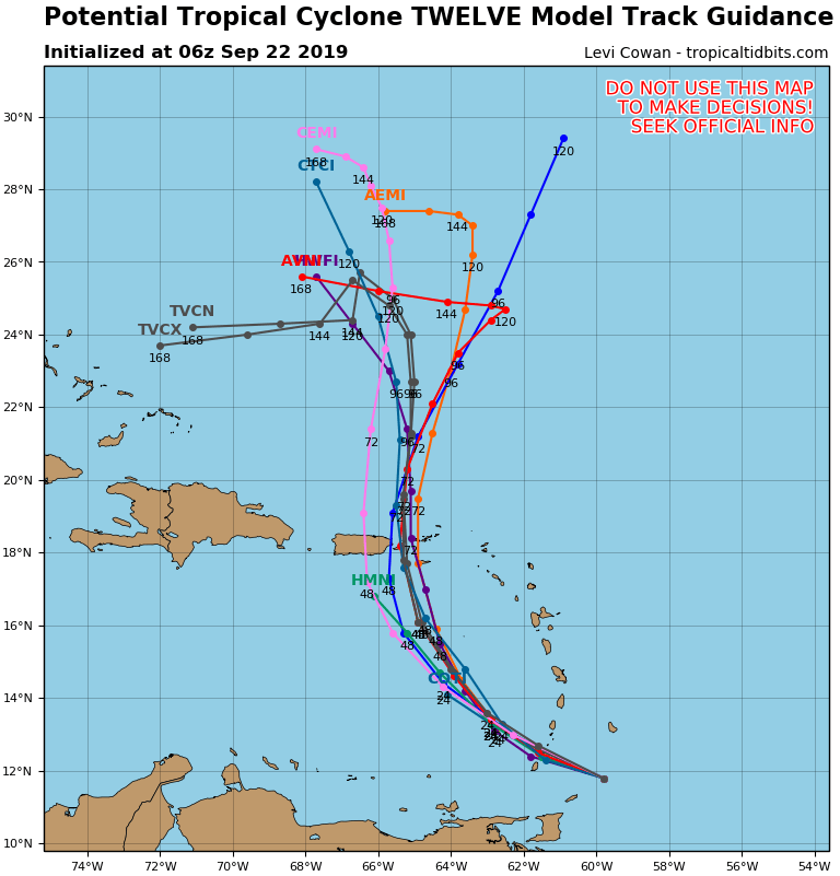
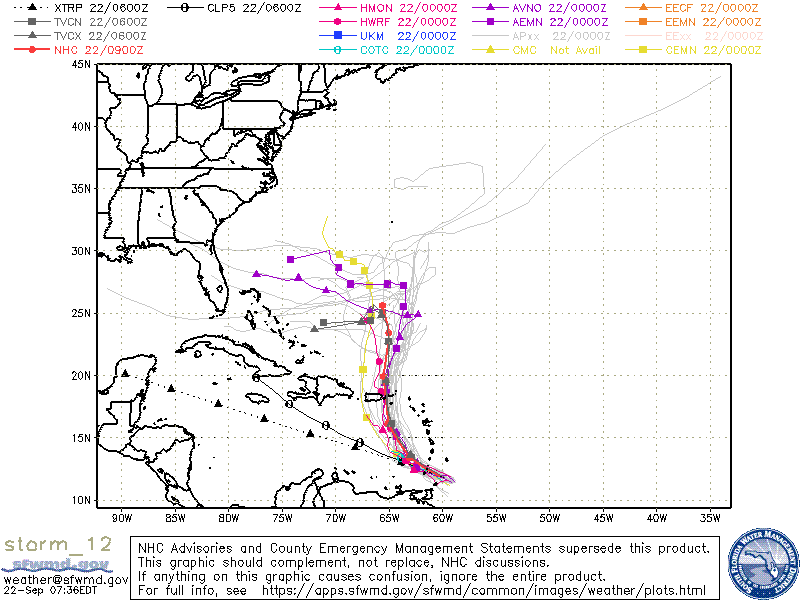
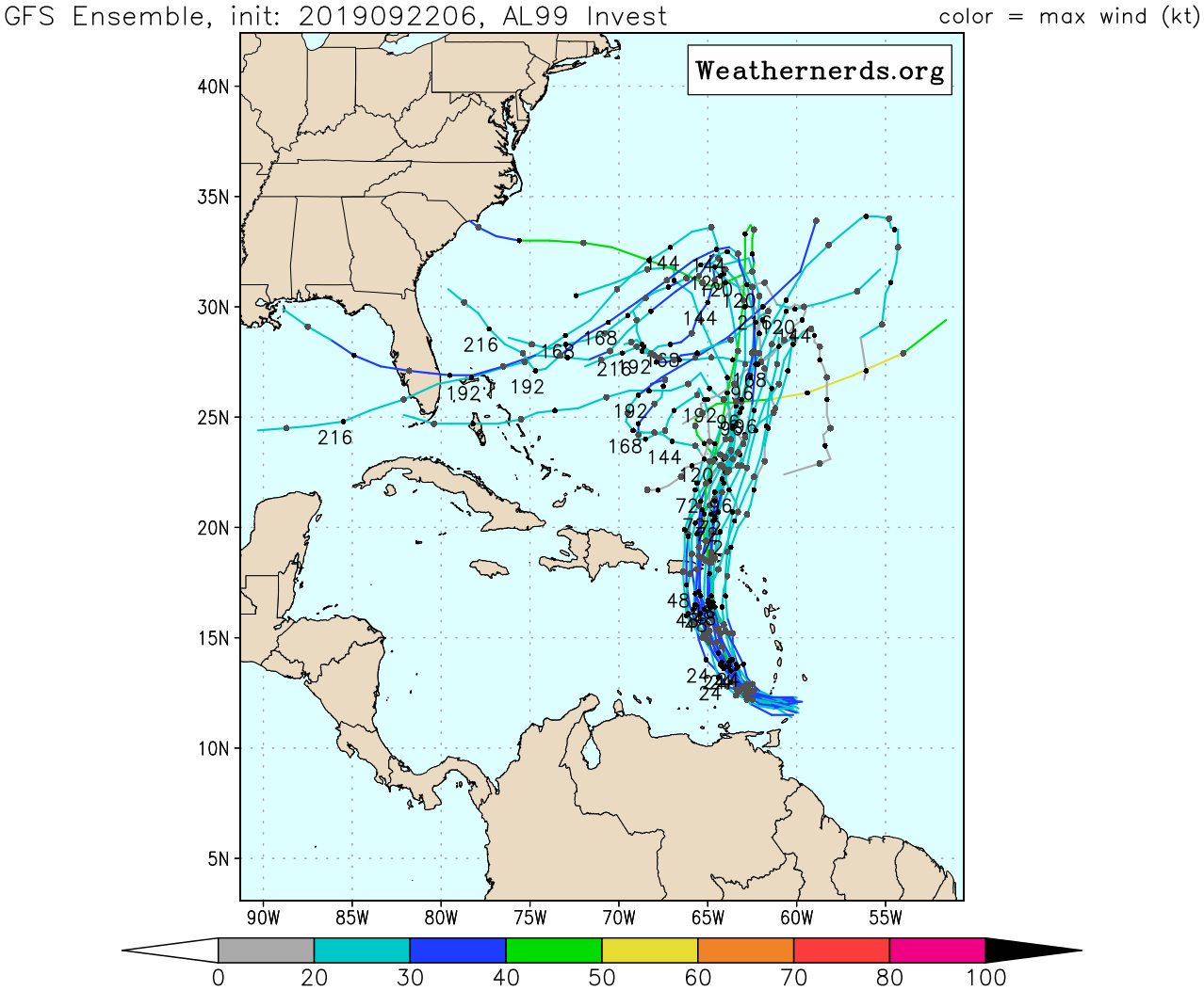
Modelos de trayectoria
-
ROCKstormSJ4315

- Tormenta Tropical

- Posts: 888
- Joined: Tue Aug 06, 2013 10:09 pm
- Location: Hato Rey, San Juan, PR
Re: Tormenta Tropical Karen afecta a las Antillas
Aunque no había posteado nada, los estaba leyendo. Durante ayer y hoy estaba hablando por teléfono con varios de los amigos foristas; quizás por eso tampoco entre antes. Les decía por teléfono que, el Invest 99 no salía bien para la foto, pero la insistencia de los expertos de la NOAA y del NWS en desarrollar un sistema del Invest, no me hacia dudar de ese hecho. Por lo general, casi a la perfección no fallan, más aún cuando el lenguaje no se fundamentaba tanto en mis amigos los modelos de trayectoria.  También decía que la trayectoria era muy extraña para septiembre. No recuerdo esa trayectoria en mucho tiempo, pero también al leer que había consenso en la misma y explicaban las razones pues tampoco lo dudaba.
No obstante, decía que tiene el domingo para desarrollarse mejor y que para mí sería sorpresa ver un huracán en tan poco tiempo, inclusive las graficas que vi en el foro sobre la intensidad a mi entender tampoco proyectaban un sistema fuerte.
También he dicho varias veces que 18 horas a dos días en meteorología es un mundo. Lo que ocurra en el día de hoy dará una proyección mejor. Veo como una vaguada que se acerca desde el este hacia el norte de PR. No he visto que se comente sobre la misma y su rol, si alguno en Karen. Durante el día de hoy se sabrá.
la lluvia es algo que me preocupa, dependera tambien de la trayectoria, cualquier ajuste en esa trayectoria hace mucha diferencia.
"Georgy Girl", The Seekers
"Back for Good", Take That
"Perfectionist", SAGA
"Graves Into Gardens", Elevation Worship ft. Brandon Lake
"Thunder", Imagine Dragons
"Viva la Vida", Coldplay
"Back for Good", Take That
"Perfectionist", SAGA
"Graves Into Gardens", Elevation Worship ft. Brandon Lake
"Thunder", Imagine Dragons
"Viva la Vida", Coldplay

Re: Tormenta Tropical Karen afecta a las Antillas
Saludo Rockstorms y demás foristas, nació Karen es un sistema difícil de proyectar su intensidad, el caza huracán hoy volará el sistema es posible que este un poco mas fuerte, la ruta lo mismo puede ser por el Canal de la Mona como por Islas Vírgenes así que hay que estar pendientes. Veremos
Re: Tormenta Tropical Karen afecta a las Antillas
Se quedo en la 11.9 en las ultimas 3 horas... 
000
WTNT32 KNHC 221153
TCPAT2
BULLETIN
Tropical Storm Karen Intermediate Advisory Number 1A
NWS National Hurricane Center Miami FL AL122019
800 AM AST Sun Sep 22 2019
...CENTER OF KAREN PASSING JUST NORTH OF TOBAGO...
SUMMARY OF 800 AM AST...1200 UTC...INFORMATION
----------------------------------------------
LOCATION...11.9N 60.9W
ABOUT 55 MI...90 KM ESE OF GRENADA
ABOUT 100 MI...160 KM SSE OF ST. VINCENT
MAXIMUM SUSTAINED WINDS...40 MPH...65 KM/H
PRESENT MOVEMENT...WNW OR 285 DEGREES AT 9 MPH...15 KM/H
MINIMUM CENTRAL PRESSURE...1005 MB...29.68 INCHES
WATCHES AND WARNINGS
--------------------
CHANGES WITH THIS ADVISORY:
The government of Barbados has issued a Tropical Storm Warning for
St. Vincent and the Grenadines.
SUMMARY OF WATCHES AND WARNINGS IN EFFECT:
A Tropical Storm Warning is in effect for...
* Trinidad and Tobago
* Grenada and its dependencies
* St. Vincent and the Grenadines
A Tropical Storm Warning means that tropical storm conditions are
expected somewhere within the warning area, in this case within the
next 12 hours.
Tropical Storm Warnings may be issued later today for other
portions of the Windward Islands. A Tropical Storm Watch will likely
be issued later today for Puerto Rico and the Virgin Islands.
Elsewhere, interests in the Leeward Islands should monitor the
progress of Karen.
A Tropical Storm Watch means that tropical storm conditions are
possible within the watch area, generally within 48 hours.
For storm information specific to your area, please monitor
products issued by your national meteorological service.
DISCUSSION AND OUTLOOK
----------------------
At 800 AM AST (1200 UTC), the center of Tropical Storm Karen was
located near latitude 11.9 North, longitude 60.9 West. Karen is
moving toward the west-northwest near 9 mph (15 km/h) and this
general motion is expected to continue today. A turn toward the
northwest is forecast to occur on Monday, followed by a turn toward
the north on Tuesday. On the forecast track, Karen will move across
the Windward Islands today, and emerge over the southeastern
Caribbean Sea tonight. On Tuesday, Karen is expected to approach
Puerto Rico and the Virgin Islands.
Maximum sustained winds are near 40 mph (65 km/h) with higher
gusts. Little change in strength is forecast during the next 48
hours.
Tropical-storm-force winds extend outward up to 125 miles (205 km)
from the center.
The estimated minimum central pressure is 1005 mb (29.68 inches).
HAZARDS AFFECTING LAND
----------------------
WIND: Tropical storm conditions are expected to first reach those
islands within the warning area this morning and afternoon, making
outside preparations difficult or dangerous.
RAINFALL: Karen is expected to produce the following rainfall
accumulations through Wednesday:
Windward Islands...3 to 6 inches, isolated 8 inches.
Leeward Islands...1 to 3 inches, isolated 5 inches.
Far northeastern Venezuela and Barbados...1 to 3 inches.
These rains may cause flash flooding and mudslides, especially in
mountainous areas.
NEXT ADVISORY
-------------
Next complete advisory at 1100 AM AST.
$$
Forecaster Brown
Re: Tormenta Tropical Karen afecta a las Antillas
Así mismo es megadicto continúa al oeste y posiblemente vendrán ajustes en la trayectoria a las 11am. Veremos
-
StormWatch
- Cat. 3

- Posts: 3755
- Joined: Thu Aug 06, 2015 11:39 am
- Location: Texas, USA
Re: Tormenta Tropical Karen afecta a las Antillas
Karen muy cerca..........
Member Since 2005
For official information, please refer to NHC: https://www.nhc.noaa.gov
Hurricane’s hit Puerto Rico:
San Felipe 1928, San Ciprián 1932, Santa Clara 1956, Hugo 1989, Marilyn 1995, Hortense 1996, Georges 1998, Maria 2017, Fiona 2022
Model Runs:
GFS:
[5:30 AM/PM, 11:30 AM/PM]
HWRF, GFDL, UKMET, NAVGEM:
[6:30-8:00 AM/PM, 12:30-2:00 AM/PM]
ECMWF:
[1:45 AM/PM]
-
StormWatch
- Cat. 3
- Posts: 3755
- Joined: Thu Aug 06, 2015 11:39 am
- Location: Texas, USA
Re: Tormenta Tropical Karen afecta a las Antillas
No será fácil un azote de Sur a Norte y plus 24 horas de lluvia 
Member Since 2005
For official information, please refer to NHC: https://www.nhc.noaa.gov
Hurricane’s hit Puerto Rico:
San Felipe 1928, San Ciprián 1932, Santa Clara 1956, Hugo 1989, Marilyn 1995, Hortense 1996, Georges 1998, Maria 2017, Fiona 2022
Model Runs:
GFS:
[5:30 AM/PM, 11:30 AM/PM]
HWRF, GFDL, UKMET, NAVGEM:
[6:30-8:00 AM/PM, 12:30-2:00 AM/PM]
ECMWF:
[1:45 AM/PM]
For official information, please refer to NHC: https://www.nhc.noaa.gov
Hurricane’s hit Puerto Rico:
San Felipe 1928, San Ciprián 1932, Santa Clara 1956, Hugo 1989, Marilyn 1995, Hortense 1996, Georges 1998, Maria 2017, Fiona 2022
Model Runs:
GFS:
[5:30 AM/PM, 11:30 AM/PM]
HWRF, GFDL, UKMET, NAVGEM:
[6:30-8:00 AM/PM, 12:30-2:00 AM/PM]
ECMWF:
[1:45 AM/PM]