¡Bienvenidos a la nueva interface gráfica de CycloForums!

Tormenta Tropical Karen.

Aquí encontrarás todo lo relacionado al la meteorología en Puerto Rico y las condiciones del tiempo actuales, así como los huracanes que se desarrollen durante las temporadas ciclónicas, actualizados por expertos y aficionados a la meteorología de todo el pais! Este es tu foro! Leelo, escribe en el y disfrútalo! Cycloman.
StormWatch
Cat. 3
Cat. 3
Posts: 3721
Joined: Thu Aug 06, 2015 11:39 am
Location: Texas, USA

Re: Invest 99l Sureste de las Antillas- 70% y 70%

Post by StormWatch »

El Europeo nos parte como melón..... :shock:

De Sur a Norte y LENTÍSIMO

Image
Member Since 2005
For official information, please refer to NHC: https://www.nhc.noaa.gov

Hurricane’s hit Puerto Rico:
San Felipe 1928, San Ciprián 1932, Santa Clara 1956, Hugo 1989, Marilyn 1995, Hortense 1996, Georges 1998, Maria 2017, Fiona 2022

Model Runs:
GFS:
[5:30 AM/PM, 11:30 AM/PM]

HWRF, GFDL, UKMET, NAVGEM:
[6:30-8:00 AM/PM, 12:30-2:00 AM/PM]

ECMWF:
[1:45 AM/PM]
StormWatch
Cat. 3
Cat. 3
Posts: 3721
Joined: Thu Aug 06, 2015 11:39 am
Location: Texas, USA

Re: Invest 99l Sureste de las Antillas- 70% y 70%

Post by StormWatch »

Esto sigue....

BOMMMMMMMMMMMMM!

Image
Member Since 2005
For official information, please refer to NHC: https://www.nhc.noaa.gov

Hurricane’s hit Puerto Rico:
San Felipe 1928, San Ciprián 1932, Santa Clara 1956, Hugo 1989, Marilyn 1995, Hortense 1996, Georges 1998, Maria 2017, Fiona 2022

Model Runs:
GFS:
[5:30 AM/PM, 11:30 AM/PM]

HWRF, GFDL, UKMET, NAVGEM:
[6:30-8:00 AM/PM, 12:30-2:00 AM/PM]

ECMWF:
[1:45 AM/PM]
User avatar
megadicto
Invest
Invest
Posts: 288
Joined: Thu Aug 27, 2015 9:50 am

Re: Invest 99L afecta a las Antillas, 80% -80%

Post by megadicto »

:shock: :shock:

000
WTNT32 KNHC 220857
TCPAT2

BULLETIN
Tropical Storm Karen Advisory Number 1
NWS National Hurricane Center Miami FL AL122019
500 AM AST Sun Sep 22 2019

...TROPICAL STORM KAREN FORMS JUST EAST OF THE WINDWARD ISLANDS...
...TROPICAL STORM WARNING ISSUED FOR PORTIONS OF THE WINDWARD
ISLANDS...


SUMMARY OF 500 AM AST...0900 UTC...INFORMATION
----------------------------------------------
LOCATION...11.9N 60.2W
ABOUT 100 MI...165 KM E OF GRENADA
ABOUT 120 MI...190 KM SE OF ST. VINCENT
MAXIMUM SUSTAINED WINDS...40 MPH...65 KM/H
PRESENT MOVEMENT...WNW OR 285 DEGREES AT 9 MPH...15 KM/H
MINIMUM CENTRAL PRESSURE...1005 MB...29.68 INCHES


WATCHES AND WARNINGS
--------------------
CHANGES WITH THIS ADVISORY:

The government of Trinidad and Tobago has issued a Tropical Storm Warning for Trinidad and Tobago. The Trinidad and Tobago Meteorological Service has issued a Tropical Storm Warning for Grenada and its dependencies.

SUMMARY OF WATCHES AND WARNINGS IN EFFECT:

A Tropical Storm Warning is in effect for...
* Trinidad and Tobago
* Grenada and its dependencies

A Tropical Storm Warning means that tropical storm conditions are expected somewhere within the warning area, in this case within the next 12 hours.

Tropical Storm Warnings may be issued later today for other portions of the Windward Islands. A Tropical Storm Watch will likely be issued later today for Puerto Rico and the Virgin Islands. Elsewhere, interests in the Leeward Islands should monitor the progress of Karen.


For storm information specific to your area, please monitor products issued by your national meteorological service.


DISCUSSION AND OUTLOOK
----------------------
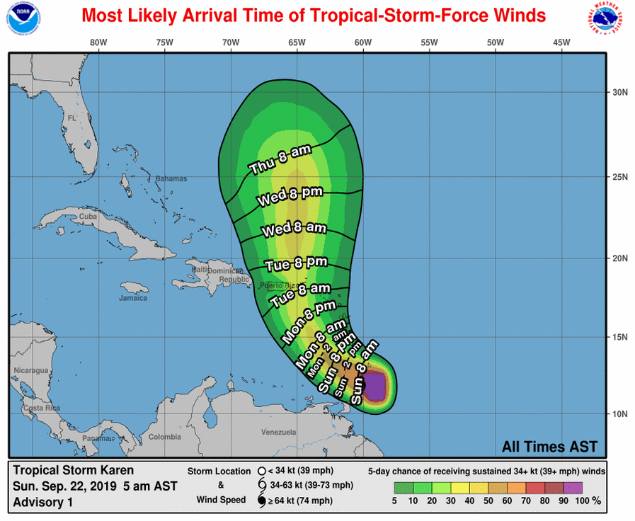
At 500 AM AST (0900 UTC), the center of newly formed Tropical Storm Karen was located near latitude 11.9 North, longitude 60.2 West.
Karen is moving toward the west-northwest near 9 mph (15 km/h) and this general motion is expected to continue today. A turn toward the northwest is forecast to occur on Monday, followed by a turn
toward the north on Tuesday. On the forecast track, Karen will move across the Windward Islands this afternoon and tonight, and emerge over the southeastern Caribbean Sea Monday morning. On Tuesday, Karen is expected to approach Puerto Rico and the Virgin Islands.

Maximum sustained winds are near 40 mph (65 km/h) with higher gusts. Little change in strength is forecast during the next 48 hours.

Tropical-storm-force winds extend outward up to 125 miles (205 km) from the center. Barbados recently reported a sustained wind of 37 mph (59 km/h) and a gust to 45 mph (72 km/h).

The estimated minimum central pressure is 1005 mb (29.68 inches).


HAZARDS AFFECTING LAND
----------------------
WIND: Tropical storm conditions are expected to first reach those islands within the warning area later this morning and afternoon, making outside preparations difficult or dangerous.

RAINFALL: Karen is expected to produce the following rainfall accumulations through Wednesday:

Windward Islands...3 to 6 inches, isolated 8 inches.

Leeward Islands...1 to 3 inches, isolated 5 inches.

Far northeastern Venezuela and Barbados...1 to 3 inches.

These rains may cause flash flooding and mudslides, especially in mountainous areas.


NEXT ADVISORY
-------------
Next intermediate advisory at 800 AM AST.
Next complete advisory at 1100 AM AST.

$$
Forecaster Stewart
Last edited by megadicto on Sun Sep 22, 2019 5:05 am, edited 2 times in total.
BAYANEY
Onda Tropical
Onda Tropical
Posts: 46
Joined: Wed Aug 07, 2013 11:43 pm

Re: Invest 99L afecta a las Antillas, 80% -80%

Post by BAYANEY »

Tenemos la tormenta Karen
-- LOCATION...11.9N 60.2W
StormWatch
Cat. 3
Cat. 3
Posts: 3721
Joined: Thu Aug 06, 2015 11:39 am
Location: Texas, USA

Re: Invest 99L afecta a las Antillas, 80% -80%

Post by StormWatch »

Uyyyyyyyyyyyyy!

Image
Member Since 2005
For official information, please refer to NHC: https://www.nhc.noaa.gov

Hurricane’s hit Puerto Rico:
San Felipe 1928, San Ciprián 1932, Santa Clara 1956, Hugo 1989, Marilyn 1995, Hortense 1996, Georges 1998, Maria 2017, Fiona 2022

Model Runs:
GFS:
[5:30 AM/PM, 11:30 AM/PM]

HWRF, GFDL, UKMET, NAVGEM:
[6:30-8:00 AM/PM, 12:30-2:00 AM/PM]

ECMWF:
[1:45 AM/PM]
BAYANEY
Onda Tropical
Onda Tropical
Posts: 46
Joined: Wed Aug 07, 2013 11:43 pm

Re: Invest 99L afecta a las Antillas, 80% -80%

Post by BAYANEY »

Image
albertopr
Onda Tropical
Onda Tropical
Posts: 45
Joined: Tue Aug 25, 2015 4:20 am

Re: Tormenta Tropical Karen afecta a las Antillas

Post by albertopr »

Nació la hija :lol:
StormWatch
Cat. 3
Cat. 3
Posts: 3721
Joined: Thu Aug 06, 2015 11:39 am
Location: Texas, USA

Re: Tormenta Tropical Karen afecta a las Antillas

Post by StormWatch »

Hmmmmm no me importa el viento, pero cuidado. Son más de 24 horas de lluvias. :o

Image
Member Since 2005
For official information, please refer to NHC: https://www.nhc.noaa.gov

Hurricane’s hit Puerto Rico:
San Felipe 1928, San Ciprián 1932, Santa Clara 1956, Hugo 1989, Marilyn 1995, Hortense 1996, Georges 1998, Maria 2017, Fiona 2022

Model Runs:
GFS:
[5:30 AM/PM, 11:30 AM/PM]

HWRF, GFDL, UKMET, NAVGEM:
[6:30-8:00 AM/PM, 12:30-2:00 AM/PM]

ECMWF:
[1:45 AM/PM]
StormWatch
Cat. 3
Cat. 3
Posts: 3721
Joined: Thu Aug 06, 2015 11:39 am
Location: Texas, USA

Re: Tormenta Tropical Karen afecta a las Antillas

Post by StormWatch »

albertopr wrote: Sun Sep 22, 2019 5:20 am Nació la hija :lol:
La hija de Maria? :mrgreen:
Member Since 2005
For official information, please refer to NHC: https://www.nhc.noaa.gov

Hurricane’s hit Puerto Rico:
San Felipe 1928, San Ciprián 1932, Santa Clara 1956, Hugo 1989, Marilyn 1995, Hortense 1996, Georges 1998, Maria 2017, Fiona 2022

Model Runs:
GFS:
[5:30 AM/PM, 11:30 AM/PM]

HWRF, GFDL, UKMET, NAVGEM:
[6:30-8:00 AM/PM, 12:30-2:00 AM/PM]

ECMWF:
[1:45 AM/PM]
StormWatch
Cat. 3
Cat. 3
Posts: 3721
Joined: Thu Aug 06, 2015 11:39 am
Location: Texas, USA

Re: Tormenta Tropical Karen afecta a las Antillas

Post by StormWatch »

Tenemos que salir de este cono.

Esto no está fácil.....No quiero un HIT TARGET
Image
Member Since 2005
For official information, please refer to NHC: https://www.nhc.noaa.gov

Hurricane’s hit Puerto Rico:
San Felipe 1928, San Ciprián 1932, Santa Clara 1956, Hugo 1989, Marilyn 1995, Hortense 1996, Georges 1998, Maria 2017, Fiona 2022

Model Runs:
GFS:
[5:30 AM/PM, 11:30 AM/PM]

HWRF, GFDL, UKMET, NAVGEM:
[6:30-8:00 AM/PM, 12:30-2:00 AM/PM]

ECMWF:
[1:45 AM/PM]
Post Reply