

Actualización
Special Tropical Weather Outlook NWS National Hurricane Center Miami FL 1100 PM EDT Sat Sep 21 2019 For the North Atlantic...Caribbean Sea and the Gulf of Mexico: Updated for the low pressure area near the Windward Islands. The National Hurricane Center is issuing advisories on Tropical Storm Jerry, located a few hundred miles north of Puerto Rico. Updated: A strong tropical wave, accompanied by a broad low pressure area located between Barbados and Tobago, is producing showers and thunderstorms that are showing signs of organization. In addition, recent satellite-derived surface wind data and observations from Barbados indicate that the disturbance is producing winds to near tropical storm force in the eastern portion of the system. Further development of this disturbance is expected over the next couple of days, and a tropical depression or tropical storm will likely form while it moves westward and then northwestward at 10 to 15 mph across the Windward Islands and over the eastern Caribbean Sea. The system is then expected to turn northward, moving near Puerto Rico and the Virgin Islands on Tuesday. Regardless of development, heavy rainfall and strong gusty winds are likely over much of the Lesser Antilles during the next couple of days and will likely spread across Puerto Rico and the Virgin Islands by Monday night or Tuesday. Interests across the eastern Caribbean should monitor the progress of this disturbance since tropical storm watches and warnings could be required for portions of the Lesser Antilles and Puerto Rico and the Virgin Islands on Sunday. * Formation chance through 48 hours...high...70 percent. * Formation chance through 5 days...high...70 percent.
Tormenta Tropical Karen.

Re: Invest 99l Sureste de las Antillas- 60% y 70%
Saludos BAYANEY ...Ea!! Lo que veía en el satélite era correcto. se está cocinando algo, veremos.BAYANEY wrote: ↑Sat Sep 21, 2019 11:06 pm Actualización
Special Tropical Weather Outlook NWS National Hurricane Center Miami FL 1100 PM EDT Sat Sep 21 2019 For the North Atlantic...Caribbean Sea and the Gulf of Mexico: Updated for the low pressure area near the Windward Islands. The National Hurricane Center is issuing advisories on Tropical Storm Jerry, located a few hundred miles north of Puerto Rico. Updated: A strong tropical wave, accompanied by a broad low pressure area located between Barbados and Tobago, is producing showers and thunderstorms that are showing signs of organization. In addition, recent satellite-derived surface wind data and observations from Barbados indicate that the disturbance is producing winds to near tropical storm force in the eastern portion of the system. Further development of this disturbance is expected over the next couple of days, and a tropical depression or tropical storm will likely form while it moves westward and then northwestward at 10 to 15 mph across the Windward Islands and over the eastern Caribbean Sea. The system is then expected to turn northward, moving near Puerto Rico and the Virgin Islands on Tuesday. Regardless of development, heavy rainfall and strong gusty winds are likely over much of the Lesser Antilles during the next couple of days and will likely spread across Puerto Rico and the Virgin Islands by Monday night or Tuesday. Interests across the eastern Caribbean should monitor the progress of this disturbance since tropical storm watches and warnings could be required for portions of the Lesser Antilles and Puerto Rico and the Virgin Islands on Sunday. * Formation chance through 48 hours...high...70 percent. * Formation chance through 5 days...high...70 percent.
-
StormWatch
- Cat. 3

- Posts: 3721
- Joined: Thu Aug 06, 2015 11:39 am
- Location: Texas, USA
Re: Invest 99l Sureste de las Antillas- 70% y 70%
Eahhhhhhh
Aviso de tormenta para mañana?
Aviso de tormenta para mañana?
Member Since 2005
For official information, please refer to NHC: https://www.nhc.noaa.gov
Hurricane’s hit Puerto Rico:
San Felipe 1928, San Ciprián 1932, Santa Clara 1956, Hugo 1989, Marilyn 1995, Hortense 1996, Georges 1998, Maria 2017, Fiona 2022
Model Runs:
GFS:
[5:30 AM/PM, 11:30 AM/PM]
HWRF, GFDL, UKMET, NAVGEM:
[6:30-8:00 AM/PM, 12:30-2:00 AM/PM]
ECMWF:
[1:45 AM/PM]
-
StormWatch
- Cat. 3
- Posts: 3721
- Joined: Thu Aug 06, 2015 11:39 am
- Location: Texas, USA
Re: Invest 99l Sureste de las Antillas- 70% y 70%
Boletín especial:
El CNH aumenta a 70% la probabilidad de desarrollo del invest 99L. Reporta vientos de tormenta en Barbados y advierten que podrían emitir vigilancias de tormenta para Puerto Rico, USVI y algunas islas de las antillas menores.
El CNH aumenta a 70% la probabilidad de desarrollo del invest 99L. Reporta vientos de tormenta en Barbados y advierten que podrían emitir vigilancias de tormenta para Puerto Rico, USVI y algunas islas de las antillas menores.
Member Since 2005
For official information, please refer to NHC: https://www.nhc.noaa.gov
Hurricane’s hit Puerto Rico:
San Felipe 1928, San Ciprián 1932, Santa Clara 1956, Hugo 1989, Marilyn 1995, Hortense 1996, Georges 1998, Maria 2017, Fiona 2022
Model Runs:
GFS:
[5:30 AM/PM, 11:30 AM/PM]
HWRF, GFDL, UKMET, NAVGEM:
[6:30-8:00 AM/PM, 12:30-2:00 AM/PM]
ECMWF:
[1:45 AM/PM]
For official information, please refer to NHC: https://www.nhc.noaa.gov
Hurricane’s hit Puerto Rico:
San Felipe 1928, San Ciprián 1932, Santa Clara 1956, Hugo 1989, Marilyn 1995, Hortense 1996, Georges 1998, Maria 2017, Fiona 2022
Model Runs:
GFS:
[5:30 AM/PM, 11:30 AM/PM]
HWRF, GFDL, UKMET, NAVGEM:
[6:30-8:00 AM/PM, 12:30-2:00 AM/PM]
ECMWF:
[1:45 AM/PM]

Re: Invest 99l Sureste de las Antillas- 60% y 70%
Bueno viendo esto y sacando análisis de lo que ha sido el Mar Caribe en los últimos dos meses, podríamos decir que habrá incertidumbre en su fuerza no en trayectoria, digo la fuerza porque el caribe ha sido un cementerio de sistemas esta temporada.
Un sistema moviéndose rápido como dice el NHC.
Vientos cortantes en altura a partir del martes.
Y un poco de aire seco.
Pondrá en competencia toda la capacidad de este sistema.
Un sistema moviéndose rápido como dice el NHC.
Vientos cortantes en altura a partir del martes.
Y un poco de aire seco.
Pondrá en competencia toda la capacidad de este sistema.
-
StormWatch
- Cat. 3
- Posts: 3721
- Joined: Thu Aug 06, 2015 11:39 am
- Location: Texas, USA
Re: Invest 99l Sureste de las Antillas- 70% y 70%
Este sistema viene a molestar y bien feo.
Debería ser huracán antes de cruzar a Puerto Rico.
Debería ser huracán antes de cruzar a Puerto Rico.
Member Since 2005
For official information, please refer to NHC: https://www.nhc.noaa.gov
Hurricane’s hit Puerto Rico:
San Felipe 1928, San Ciprián 1932, Santa Clara 1956, Hugo 1989, Marilyn 1995, Hortense 1996, Georges 1998, Maria 2017, Fiona 2022
Model Runs:
GFS:
[5:30 AM/PM, 11:30 AM/PM]
HWRF, GFDL, UKMET, NAVGEM:
[6:30-8:00 AM/PM, 12:30-2:00 AM/PM]
ECMWF:
[1:45 AM/PM]
For official information, please refer to NHC: https://www.nhc.noaa.gov
Hurricane’s hit Puerto Rico:
San Felipe 1928, San Ciprián 1932, Santa Clara 1956, Hugo 1989, Marilyn 1995, Hortense 1996, Georges 1998, Maria 2017, Fiona 2022
Model Runs:
GFS:
[5:30 AM/PM, 11:30 AM/PM]
HWRF, GFDL, UKMET, NAVGEM:
[6:30-8:00 AM/PM, 12:30-2:00 AM/PM]
ECMWF:
[1:45 AM/PM]
-
StormWatch
- Cat. 3
- Posts: 3721
- Joined: Thu Aug 06, 2015 11:39 am
- Location: Texas, USA
Re: Invest 99l Sureste de las Antillas- 70% y 70%
Lo comento pq puede tener una rápida intensificación.
Member Since 2005
For official information, please refer to NHC: https://www.nhc.noaa.gov
Hurricane’s hit Puerto Rico:
San Felipe 1928, San Ciprián 1932, Santa Clara 1956, Hugo 1989, Marilyn 1995, Hortense 1996, Georges 1998, Maria 2017, Fiona 2022
Model Runs:
GFS:
[5:30 AM/PM, 11:30 AM/PM]
HWRF, GFDL, UKMET, NAVGEM:
[6:30-8:00 AM/PM, 12:30-2:00 AM/PM]
ECMWF:
[1:45 AM/PM]
For official information, please refer to NHC: https://www.nhc.noaa.gov
Hurricane’s hit Puerto Rico:
San Felipe 1928, San Ciprián 1932, Santa Clara 1956, Hugo 1989, Marilyn 1995, Hortense 1996, Georges 1998, Maria 2017, Fiona 2022
Model Runs:
GFS:
[5:30 AM/PM, 11:30 AM/PM]
HWRF, GFDL, UKMET, NAVGEM:
[6:30-8:00 AM/PM, 12:30-2:00 AM/PM]
ECMWF:
[1:45 AM/PM]
Re: Invest 99l Sureste de las Antillas- 70% y 70%
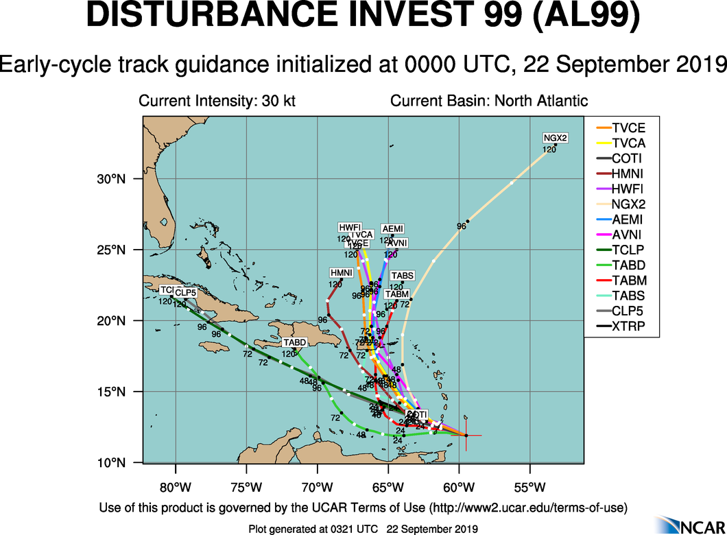
Posible Trayectoria -
será una noche larga, de desvelos en estos días
será una noche larga, de desvelos en estos días
Re: Invest 99l Sureste de las Antillas- 70% y 70%
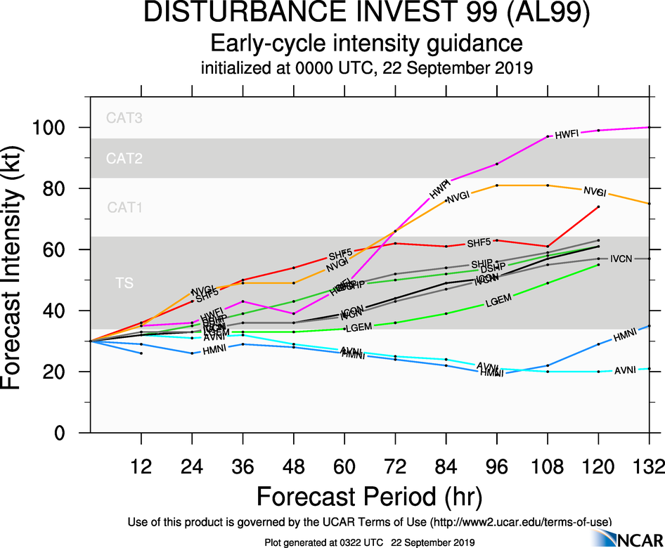
Modelos de intensidad


-
StormWatch
- Cat. 3
- Posts: 3721
- Joined: Thu Aug 06, 2015 11:39 am
- Location: Texas, USA
Re: Invest 99l Sureste de las Antillas- 70% y 70%
Lean esto:
- Invest #99L has produced sustained winds up to 50 KM/H and gusts to 70 KM/H at Grantley Adams International Airport in Barbados.
As showers and thunderstorms approach T&T, wind gusts in excess of 65 KM/H are expected.
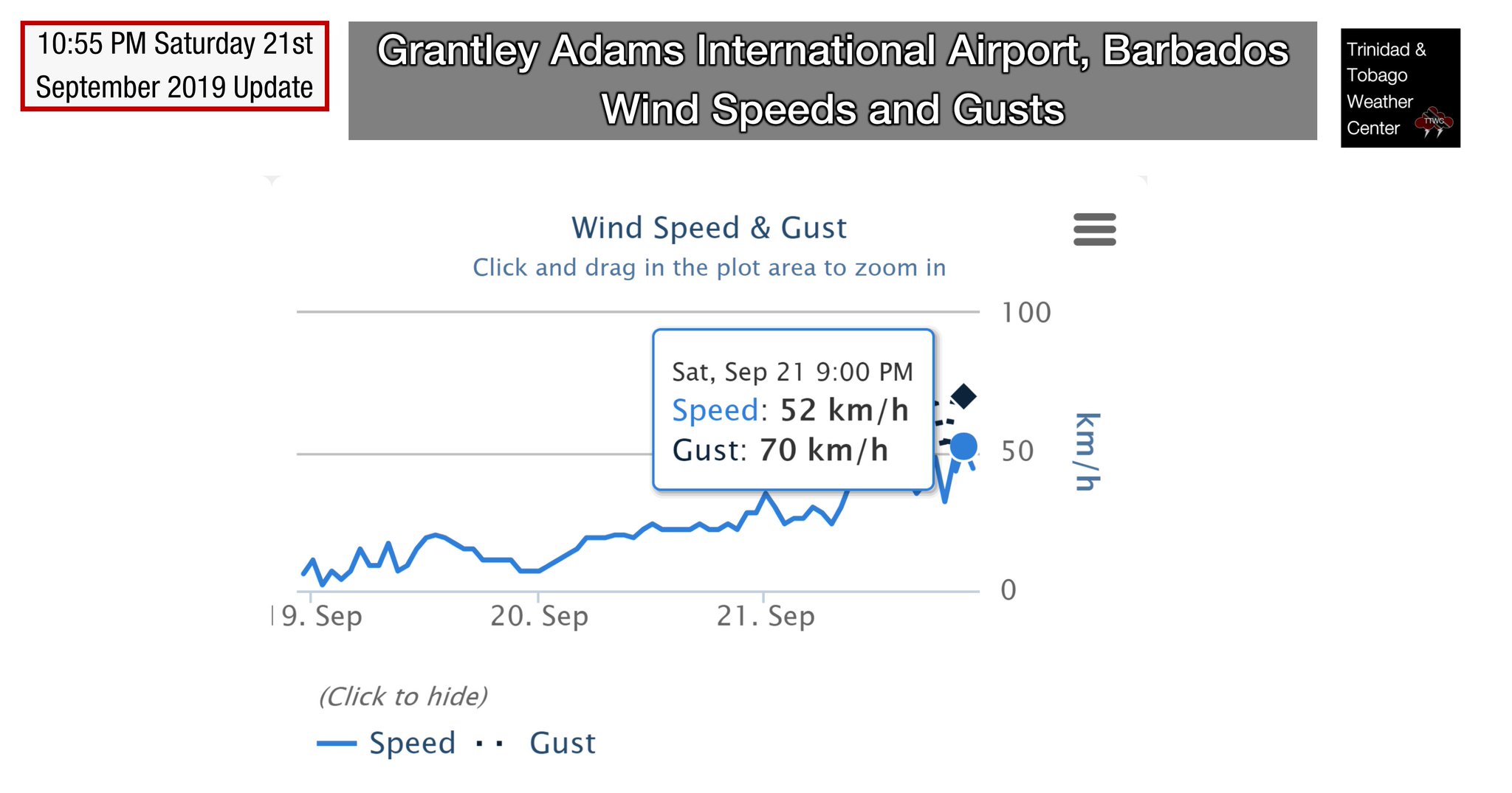
WOWWWWWW!
- Invest #99L has produced sustained winds up to 50 KM/H and gusts to 70 KM/H at Grantley Adams International Airport in Barbados.
As showers and thunderstorms approach T&T, wind gusts in excess of 65 KM/H are expected.
WOWWWWWW!
Member Since 2005
For official information, please refer to NHC: https://www.nhc.noaa.gov
Hurricane’s hit Puerto Rico:
San Felipe 1928, San Ciprián 1932, Santa Clara 1956, Hugo 1989, Marilyn 1995, Hortense 1996, Georges 1998, Maria 2017, Fiona 2022
Model Runs:
GFS:
[5:30 AM/PM, 11:30 AM/PM]
HWRF, GFDL, UKMET, NAVGEM:
[6:30-8:00 AM/PM, 12:30-2:00 AM/PM]
ECMWF:
[1:45 AM/PM]
For official information, please refer to NHC: https://www.nhc.noaa.gov
Hurricane’s hit Puerto Rico:
San Felipe 1928, San Ciprián 1932, Santa Clara 1956, Hugo 1989, Marilyn 1995, Hortense 1996, Georges 1998, Maria 2017, Fiona 2022
Model Runs:
GFS:
[5:30 AM/PM, 11:30 AM/PM]
HWRF, GFDL, UKMET, NAVGEM:
[6:30-8:00 AM/PM, 12:30-2:00 AM/PM]
ECMWF:
[1:45 AM/PM]