
Huracán Irma
-
categoria5
- Onda Tropical

- Posts: 46
- Joined: Mon Aug 17, 2015 12:33 am
Re: Huracan Irma - Categoría 3
3:32am.!!! Viene Boricua que tenemos que estar ready.!!!
-
StormWatch
- Cat. 3

- Posts: 3721
- Joined: Thu Aug 06, 2015 11:39 am
- Location: Texas, USA
Re: Huracan Irma - Categoría 3
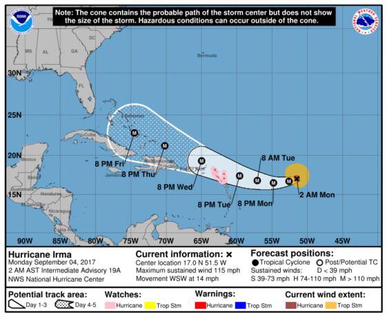
Boletín intermedio 2:00am Mon Sep 4
Huracán Irma
Location: 17.0°N 51.5°W
Moving: WSW at 14 mph
Min pressure: 961 mb
Max sustained: 115 mph
Huracán Irma
Location: 17.0°N 51.5°W
Moving: WSW at 14 mph
Min pressure: 961 mb
Max sustained: 115 mph
Member Since 2005
For official information, please refer to NHC: https://www.nhc.noaa.gov
Hurricane’s hit Puerto Rico:
San Felipe 1928, San Ciprián 1932, Santa Clara 1956, Hugo 1989, Marilyn 1995, Hortense 1996, Georges 1998, Maria 2017, Fiona 2022
Model Runs:
GFS:
[5:30 AM/PM, 11:30 AM/PM]
HWRF, GFDL, UKMET, NAVGEM:
[6:30-8:00 AM/PM, 12:30-2:00 AM/PM]
ECMWF:
[1:45 AM/PM]
-
StormWatch
- Cat. 3
- Posts: 3721
- Joined: Thu Aug 06, 2015 11:39 am
- Location: Texas, USA
Re: Huracan Irma - Categoría 3
Esta por la 16.7 y 50.7

Member Since 2005
For official information, please refer to NHC: https://www.nhc.noaa.gov
Hurricane’s hit Puerto Rico:
San Felipe 1928, San Ciprián 1932, Santa Clara 1956, Hugo 1989, Marilyn 1995, Hortense 1996, Georges 1998, Maria 2017, Fiona 2022
Model Runs:
GFS:
[5:30 AM/PM, 11:30 AM/PM]
HWRF, GFDL, UKMET, NAVGEM:
[6:30-8:00 AM/PM, 12:30-2:00 AM/PM]
ECMWF:
[1:45 AM/PM]
For official information, please refer to NHC: https://www.nhc.noaa.gov
Hurricane’s hit Puerto Rico:
San Felipe 1928, San Ciprián 1932, Santa Clara 1956, Hugo 1989, Marilyn 1995, Hortense 1996, Georges 1998, Maria 2017, Fiona 2022
Model Runs:
GFS:
[5:30 AM/PM, 11:30 AM/PM]
HWRF, GFDL, UKMET, NAVGEM:
[6:30-8:00 AM/PM, 12:30-2:00 AM/PM]
ECMWF:
[1:45 AM/PM]
-
ROCKstormSJ4315

- Tormenta Tropical

- Posts: 888
- Joined: Tue Aug 06, 2013 10:09 pm
- Location: Hato Rey, San Juan, PR
Re: Huracan Irma - Categoría 3
Tardan, parece que han hecho cambio Al texto. Veremos
"Georgy Girl", The Seekers
"Back for Good", Take That
"Perfectionist", SAGA
"Graves Into Gardens", Elevation Worship ft. Brandon Lake
"Thunder", Imagine Dragons
"Viva la Vida", Coldplay
"Back for Good", Take That
"Perfectionist", SAGA
"Graves Into Gardens", Elevation Worship ft. Brandon Lake
"Thunder", Imagine Dragons
"Viva la Vida", Coldplay

Re: Huracan Irma - Categoría 3
Buenos Días
Irma fuerte. Esperando el boletín. Creo que vienen más ajustes
Irma fuerte. Esperando el boletín. Creo que vienen más ajustes
Re: Huracan Irma - Categoría 3
000
WTNT31 KNHC 040854
TCPAT1
BULLETIN
Hurricane Irma Advisory Number 20
NWS National Hurricane Center Miami FL AL112017
500 AM AST Mon Sep 04 2017
...TROPICAL-STORM-FORCE WINDS EXPECTED TO BEGIN IN THE LEEWARD
ISLANDS LATE TUESDAY...
SUMMARY OF 500 AM AST...0900 UTC...INFORMATION
----------------------------------------------
LOCATION...16.9N 52.3W
ABOUT 625 MI...1010 KM E OF THE LEEWARD ISLANDS
MAXIMUM SUSTAINED WINDS...115 MPH...185 KM/H
PRESENT MOVEMENT...WSW OR 255 DEGREES AT 14 MPH...22 KM/H
MINIMUM CENTRAL PRESSURE...961 MB...28.38 INCHES
WATCHES AND WARNINGS
--------------------
CHANGES WITH THIS ADVISORY:
None.
SUMMARY OF WATCHES AND WARNINGS IN EFFECT:
A Hurricane Watch is in effect for...
* Antigua, Barbuda, Anguilla, Montserrat, St. Kitts, and Nevis
* Saba, St. Eustatius, and Sint Maarten
* Saint Martin and Saint Barthelemy
A Hurricane Watch means that hurricane conditions are possible
within the watch area. A watch is typically issued 48 hours
before the anticipated first occurrence of tropical-storm-force
winds, conditions that make outside preparations difficult or
dangerous.
Interests in the remainder of the Leeward Islands, the British and
U.S. Virgin Islands, Puerto Rico, and the Dominican Republic should
monitor the progress of Irma. Additional hurricane and tropical
storm watches and warnings will likely be required for portions of
this area later today.
For storm information specific to your area, please monitor
products issued by your national meteorological service.
DISCUSSION AND 48-HOUR OUTLOOK
------------------------------
At 500 AM AST (0900 UTC), the eye of Hurricane Irma was located near
latitude 16.9 North, longitude 52.3 West. Irma is moving toward
the west-southwest near 14 mph (22 km/h). A turn toward the west
is expected later today, followed by a west-northwestward turn late
Tuesday. On the forecast track, the center of Irma will move
closer to the Leeward Islands through Tuesday and then be near the
northern Leeward Islands Tuesday night.
Maximum sustained winds are near 115 mph (185 km/h) with higher
gusts. Irma is a category 3 hurricane on the Saffir-Simpson
Hurricane Wind Scale. Some strengthening is forecast through
Tuesday night.
Hurricane-force winds extend outward up to 30 miles (45 km) from the
center, and tropical-storm-force winds extend outward up to 140
miles (220 km).
The estimated minimum central pressure is 961 mb (28.38 inches).
HAZARDS AFFECTING LAND
----------------------
WIND: Hurricane conditions are possible within the watch area by
Tuesday night, with tropical storm conditions possible by late
Tuesday.
SURF: Swells generated by Irma will begin affecting the northern
Leeward Islands today. These swells are likely to cause
life-threatening surf and rip current conditions. Please consult
products from your local weather office.
NEXT ADVISORY
-------------
Next intermediate advisory at 800 AM AST.
Next complete advisory at 1100 AM AST.
$$
Forecaster Berg
-
ROCKstormSJ4315
- Tormenta Tropical
- Posts: 888
- Joined: Tue Aug 06, 2013 10:09 pm
- Location: Hato Rey, San Juan, PR
Re: Huracan Irma - Categoría 3
No veo cambios en Los avisos pero creo que la ajustaron mas cerca a PR.
"Georgy Girl", The Seekers
"Back for Good", Take That
"Perfectionist", SAGA
"Graves Into Gardens", Elevation Worship ft. Brandon Lake
"Thunder", Imagine Dragons
"Viva la Vida", Coldplay
"Back for Good", Take That
"Perfectionist", SAGA
"Graves Into Gardens", Elevation Worship ft. Brandon Lake
"Thunder", Imagine Dragons
"Viva la Vida", Coldplay
Re: Huracan Irma - Categoría 3
Según leo esperan hoy ese cambio wnw y creo que influye en aguantar algo los avisos. Estamos ante un escenario que podría ser muy serio. Los sigo leyendo. No quiero pensar en un direct hit. Saben cuando sale ese primer casa hoy?
-
ROCKstormSJ4315
- Tormenta Tropical
- Posts: 888
- Joined: Tue Aug 06, 2013 10:09 pm
- Location: Hato Rey, San Juan, PR
Re: Huracan Irma - Categoría 3
Pense que Al menos habria Watch para IV pero no fue asi. El de Las 11 AM creo que sera muy importante.
"Georgy Girl", The Seekers
"Back for Good", Take That
"Perfectionist", SAGA
"Graves Into Gardens", Elevation Worship ft. Brandon Lake
"Thunder", Imagine Dragons
"Viva la Vida", Coldplay
"Back for Good", Take That
"Perfectionist", SAGA
"Graves Into Gardens", Elevation Worship ft. Brandon Lake
"Thunder", Imagine Dragons
"Viva la Vida", Coldplay
-
ROCKstormSJ4315
- Tormenta Tropical
- Posts: 888
- Joined: Tue Aug 06, 2013 10:09 pm
- Location: Hato Rey, San Juan, PR
Re: Huracan Irma - Categoría 3
Del TWD de Las 5 AM
FORECAST POSITIONS AND MAX WINDS
INIT 04/0900Z 16.9N 52.3W 100 KT 115 MPH
12H 04/1800Z 16.7N 53.9W 105 KT 120 MPH
24H 05/0600Z 16.6N 56.2W 110 KT 125 MPH
36H 05/1800Z 17.0N 58.6W 115 KT 130 MPH
48H 06/0600Z 17.8N 61.2W 120 KT 140 MPH
72H 07/0600Z 19.6N 66.8W 120 KT 140 MPH
96H 08/0600Z 21.0N 72.0W 115 KT 130 MPH
120H 09/0600Z 22.0N 76.5W 110 KT 125 MPH
Eso es mas cerca que antes.
"Georgy Girl", The Seekers
"Back for Good", Take That
"Perfectionist", SAGA
"Graves Into Gardens", Elevation Worship ft. Brandon Lake
"Thunder", Imagine Dragons
"Viva la Vida", Coldplay
"Back for Good", Take That
"Perfectionist", SAGA
"Graves Into Gardens", Elevation Worship ft. Brandon Lake
"Thunder", Imagine Dragons
"Viva la Vida", Coldplay