INVEST 92L
-
StormWatch
- Cat. 3

- Posts: 3755
- Joined: Thu Aug 06, 2015 11:39 am
- Location: Texas, USA
Re: INVEST 92L detras de Harvey: 60%-60%
Yesss! Set! Hoy barremos los Mets, la compu con el zoom puesto en el floater del Invest 92L y un supuesto “café” el café es mentira, pq por aquí no se puede escribir sobre Jjjaajjaa!


Member Since 2005
For official information, please refer to NHC: https://www.nhc.noaa.gov
Hurricane’s hit Puerto Rico:
San Felipe 1928, San Ciprián 1932, Santa Clara 1956, Hugo 1989, Marilyn 1995, Hortense 1996, Georges 1998, Maria 2017, Fiona 2022
Model Runs:
GFS:
[5:30 AM/PM, 11:30 AM/PM]
HWRF, GFDL, UKMET, NAVGEM:
[6:30-8:00 AM/PM, 12:30-2:00 AM/PM]
ECMWF:
[1:45 AM/PM]
Re: INVEST 92L detras de Harvey: 60%-60%
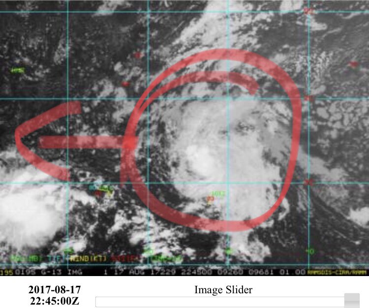
Tiene una vaguada al norte... y lleva 2 horas olvidandose de ella.
Re: INVEST 92L detras de Harvey: 60%-60%
Esos brinquitos al Oeste son los que le dan sabor al foro!! 
Re: INVEST 92L detras de Harvey: 60%-60%
Estaba viendo el weather channel y el shear le está dando alguito al norte pero entrando en aguas bien calidas. 

Re: INVEST 92L detras de Harvey: 60%-60%
Siempre pense que esta tendria mas posibilidades de afectarnos que Harvey... yo no diria que va due west pero va como a 280 mas o menos
pero tampoco pienso que llegue a ser algo importante y si lo hace seria antes de llegar a nuestras costas para luego romperse
ES SOLO UNA OPINION PERSONAL

pero tampoco pienso que llegue a ser algo importante y si lo hace seria antes de llegar a nuestras costas para luego romperse
ES SOLO UNA OPINION PERSONAL
-
StormWatch
- Cat. 3

- Posts: 3755
- Joined: Thu Aug 06, 2015 11:39 am
- Location: Texas, USA
Re: INVEST 92L detras de Harvey: 60%-60%
Se ve bien, espero q el boletín de las 8pm le suban los % a 80-80!
Shhhh callaito 3-0 Yankees

Shhhh callaito 3-0 Yankees

Member Since 2005
For official information, please refer to NHC: https://www.nhc.noaa.gov
Hurricane’s hit Puerto Rico:
San Felipe 1928, San Ciprián 1932, Santa Clara 1956, Hugo 1989, Marilyn 1995, Hortense 1996, Georges 1998, Maria 2017, Fiona 2022
Model Runs:
GFS:
[5:30 AM/PM, 11:30 AM/PM]
HWRF, GFDL, UKMET, NAVGEM:
[6:30-8:00 AM/PM, 12:30-2:00 AM/PM]
ECMWF:
[1:45 AM/PM]
For official information, please refer to NHC: https://www.nhc.noaa.gov
Hurricane’s hit Puerto Rico:
San Felipe 1928, San Ciprián 1932, Santa Clara 1956, Hugo 1989, Marilyn 1995, Hortense 1996, Georges 1998, Maria 2017, Fiona 2022
Model Runs:
GFS:
[5:30 AM/PM, 11:30 AM/PM]
HWRF, GFDL, UKMET, NAVGEM:
[6:30-8:00 AM/PM, 12:30-2:00 AM/PM]
ECMWF:
[1:45 AM/PM]
-
StormWatch
- Cat. 3

- Posts: 3755
- Joined: Thu Aug 06, 2015 11:39 am
- Location: Texas, USA
Re: INVEST 92L detras de Harvey: 60%-60%
UPPPPPPPPPP
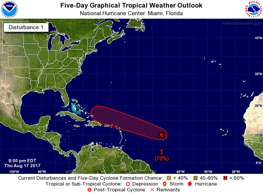
70% - 70%
As of 8:00 pm EDT Thu Aug 17 2017 ...
Shower and thunderstorm activity associated with an area of low
pressure located about 1000 miles east of the Leeward Islands have
changed little in organization during the past several hours.
However, only a slight increase in the organization of the shower
activity could lead to the formation of a tropical depression during
the next couple of days before upper-level winds become less
favorable for development early next week. The low is expected
to move west-northwestward at about 20 mph during the next few
days, and interests in the northern Leeward Islands should monitor
the progress of this disturbance.
* Formation chance through 48 hours...high...70 percent.
Member Since 2005
For official information, please refer to NHC: https://www.nhc.noaa.gov
Hurricane’s hit Puerto Rico:
San Felipe 1928, San Ciprián 1932, Santa Clara 1956, Hugo 1989, Marilyn 1995, Hortense 1996, Georges 1998, Maria 2017, Fiona 2022
Model Runs:
GFS:
[5:30 AM/PM, 11:30 AM/PM]
HWRF, GFDL, UKMET, NAVGEM:
[6:30-8:00 AM/PM, 12:30-2:00 AM/PM]
ECMWF:
[1:45 AM/PM]
For official information, please refer to NHC: https://www.nhc.noaa.gov
Hurricane’s hit Puerto Rico:
San Felipe 1928, San Ciprián 1932, Santa Clara 1956, Hugo 1989, Marilyn 1995, Hortense 1996, Georges 1998, Maria 2017, Fiona 2022
Model Runs:
GFS:
[5:30 AM/PM, 11:30 AM/PM]
HWRF, GFDL, UKMET, NAVGEM:
[6:30-8:00 AM/PM, 12:30-2:00 AM/PM]
ECMWF:
[1:45 AM/PM]
Re: INVEST 92L detras de Harvey: 60%-60%
El sistema luce saludable y está a nada de convertirse en Depresión Tropical. Una pena que esté aún tan alejado porque el avión podría toparse con un sistema ciclónico por lo bien que luce en el satélite. Esperamos que siga ¨resvalando¨ hacia el oeste para pase cerca del noreste nuestro. 
Re: INVEST 92L detras de Harvey: 60%-60%
vamo a echarle azucar!!!
-
StormWatch
- Cat. 3

- Posts: 3755
- Joined: Thu Aug 06, 2015 11:39 am
- Location: Texas, USA
Re: INVEST 92L detras de Harvey: 60%-60%
Más cerca al Norte de PR y la República Dominicana.Eguie wrote: ↑Thu Aug 17, 2017 7:49 pm El sistema luce saludable y está a nada de convertirse en Depresión Tropical. Una pena que esté aún tan alejado porque el avión podría toparse con un sistema ciclónico por lo bien que luce en el satélite. Esperamos que siga ¨resvalando¨ hacia el oeste para pase cerca del noreste nuestro.
Veremos q traen los modelos de trayectoria.

Member Since 2005
For official information, please refer to NHC: https://www.nhc.noaa.gov
Hurricane’s hit Puerto Rico:
San Felipe 1928, San Ciprián 1932, Santa Clara 1956, Hugo 1989, Marilyn 1995, Hortense 1996, Georges 1998, Maria 2017, Fiona 2022
Model Runs:
GFS:
[5:30 AM/PM, 11:30 AM/PM]
HWRF, GFDL, UKMET, NAVGEM:
[6:30-8:00 AM/PM, 12:30-2:00 AM/PM]
ECMWF:
[1:45 AM/PM]
For official information, please refer to NHC: https://www.nhc.noaa.gov
Hurricane’s hit Puerto Rico:
San Felipe 1928, San Ciprián 1932, Santa Clara 1956, Hugo 1989, Marilyn 1995, Hortense 1996, Georges 1998, Maria 2017, Fiona 2022
Model Runs:
GFS:
[5:30 AM/PM, 11:30 AM/PM]
HWRF, GFDL, UKMET, NAVGEM:
[6:30-8:00 AM/PM, 12:30-2:00 AM/PM]
ECMWF:
[1:45 AM/PM]


