Aquí encontrarás todo lo relacionado al la meteorología en Puerto Rico y las condiciones del tiempo actuales, así como los huracanes que se desarrollen durante las temporadas ciclónicas, actualizados por expertos y aficionados a la meteorología de todo el pais! Este es tu foro! Leelo, escribe en el y disfrútalo! Cycloman.
Tropical Weather Outlook
NWS National Hurricane Center Miami FL
200 AM EDT Wed Jun 14 2017
For the North Atlantic...Caribbean Sea and the Gulf of Mexico:
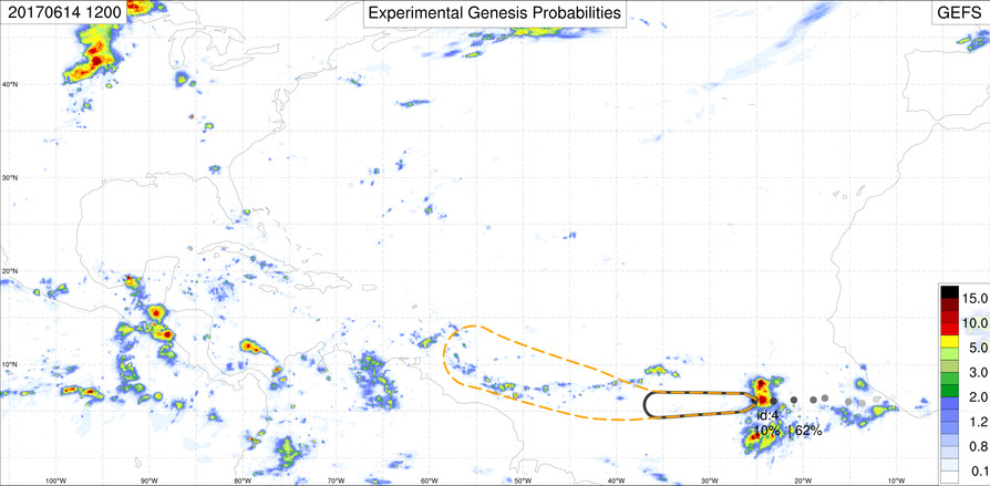
1. A strong tropical wave over the far eastern Atlantic Ocean is
producing a large area of showers and thunderstorms well south of
the Cabo Verde Islands. Development, if any, of this system is
expected to be slow to occur over the next several days while the
wave moves westward at 15 to 20 mph over the low-latitude tropical
Atlantic.
* Formation chance through 48 hours...low...10 percent.
* Formation chance through 5 days...low...20 percent.
2. A broad area of low pressure is expected to form over the
northwestern Caribbean Sea and adjacent land areas by the weekend.
Some gradual development of this system is possible thereafter while
it moves slowly northwestward toward the southwestern Gulf of
Mexico.
* Formation chance through 48 hours...low...near 0 percent.
* Formation chance through 5 days...low...20 percent.
Tropical Weather Outlook
NWS National Hurricane Center Miami FL
800 AM EDT Wed Jun 14 2017
For the North Atlantic...Caribbean Sea and the Gulf of Mexico:
A large area of showers and thunderstorms several hundred miles
south of the Cabo Verde Islands is associated with a strong
tropical wave. Development, if any, of this system is expected to
be slow to occur during the next several days while the wave moves
westward near 20 mph over the tropical Atlantic.
* Formation chance through 48 hours...low...10 percent.
* Formation chance through 5 days...low...20 percent.
emh- huracan es simplemente ahora Edgardo. Importante: Phil Klotzbach, recordó que "el mejor momento para prepararse para los huracanes es cuando todavía no hay huracanes".
dos áreas de sospecha ciclónica con baja probabilidad (20%) en 5 días. Onda tropical al sur de islas de Cabo Verde (long 25 O) llega al sur de Puerto Rico el miércoles próximo sin efectos directos, pero seguiré vigilante. Otra área en Mar Caribe occidental es de interés para costas de México hacia el Golfo de México este fin de semsna.
Sin embargo, hay otra onda tropical cerca de long 35 O que debe llegar con buena actividad de lluvia en PR el lunes.
emh- huracan es simplemente ahora Edgardo. Importante: Phil Klotzbach, recordó que "el mejor momento para prepararse para los huracanes es cuando todavía no hay huracanes".
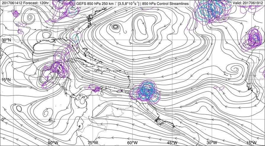
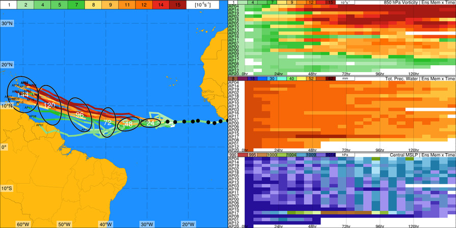
Saludos Arlequin, Edgardo y amigos foristas buena sorpresa pintura amarrilla desde el sur de Cabo Verde, por otro lado en algún momento los modelos han propuesto el desarrollo y los que se han mantenido consistente en desarrollo en corridas consecutivas resientes son el CMC y GFS, pero el europeo, navgem y ukmet también olfatean bien. Veremos que pasa con esta grata sorpresa.
Tropical Weather Outlook
NWS National Hurricane Center Miami FL
200 AM EDT Thu Jun 15 2017
For the North Atlantic...Caribbean Sea and the Gulf of Mexico:
An area of disturbed weather associated with a tropical wave is
located well south-southwest of the Cabo Verde Islands. Some gradual
development of this system is possible during the next few days
while the wave moves westward near 20 mph over the tropical
Atlantic.
* Formation chance through 48 hours...low...10 percent.
* Formation chance through 5 days...low...20 percent.
Le han dado alguna posibilidad de desarrollo ciclonico a esa ondita y a juzgar por su comportamiento en la manana de hoy, se lo esta tomando muy en serio.
Hay un par de ondas dentro de Africa con muy buena presentacion para ser ondas de Junio. De la manera en que luce la MDR, segun los mapas y la alineacion planetaria...parece que tendremos un verano bastante ocupado segun yo, deberiamos estar muy cerca de 19 sistemas ciclonicos al final de la jornada, asi que vaya juntando lata desde ahora
Saludos,, de nuevo a la carga ultimo TWO 8am
Tropical Weather Outlook
NWS National Hurricane Center Miami FL
800 AM EDT Fri Jun 16 2017
For the North Atlantic...Caribbean Sea and the Gulf of Mexico:
Cloudiness and showers associated with a tropical wave located
several hundred miles southwest of the Cabo Verde Islands have
become better organized since yesterday. Additional slow
development is possible during the next few days while the wave
moves westward at 15-20 mph over the tropical Atlantic.
* Formation chance through 48 hours...low...20 percent.
* Formation chance through 5 days...medium...40 percent.
A broad area of low pressure is expected to form over the
northwestern Caribbean Sea and the Yucatan peninsula during the
next day or two. Conditions appear to be favorable for gradual
development of this system while it moves slowly northwestward
into the southern Gulf of Mexico early next week.
* Formation chance through 48 hours...low...near 0 percent.
* Formation chance through 5 days...medium...60 percent.
$$
Para información oficial favor referirse a las agencias pertinentes. Un aficionado a la meteorología #TeamCycloforums