

Huracán Matthew
-
StormWatch
- Cat. 3

- Posts: 3741
- Joined: Thu Aug 06, 2015 11:39 am
- Location: Texas, USA
Re: Huracán Matthew
Close up Matthew
Member Since 2005
For official information, please refer to NHC: https://www.nhc.noaa.gov
Hurricane’s hit Puerto Rico:
San Felipe 1928, San Ciprián 1932, Santa Clara 1956, Hugo 1989, Marilyn 1995, Hortense 1996, Georges 1998, Maria 2017, Fiona 2022
Model Runs:
GFS:
[5:30 AM/PM, 11:30 AM/PM]
HWRF, GFDL, UKMET, NAVGEM:
[6:30-8:00 AM/PM, 12:30-2:00 AM/PM]
ECMWF:
[1:45 AM/PM]

Re: Huracán Matthew
Ahora que el shear ha disminuido bastante y hay aguas mas calientes al norte, Matthew pudiera nuevamante alcanzar la categoria 5 durante la madrugada...si se mantiene sobre agua, el azote mayor en terminos de vientos pudiera ser al area de Guantanamo, si pasa sobre el exteemos suroeste de Haiti. hay un mazico montanoso en esa zona que pudiera contribuir a disrumpir temporalmente la circulacion de Matthew, aunque no por mucho siendo una franja relativamanete estrecha de tierra.
El escenario en general es feo, muy feo...Dios los proteja.
Nota al margen:
Imagenes de un fenomeno muy llamativo ocurrido sobre Puerto Rico tras el paso de Matthews al sur.
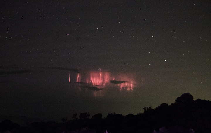
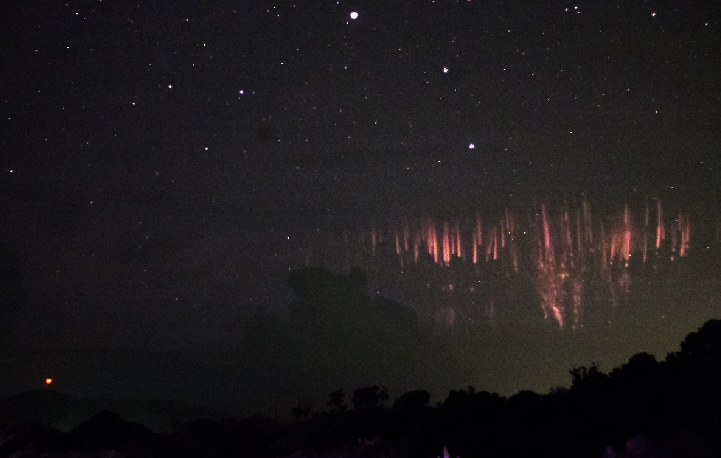
"Sprites" sobre el cielo de la isla__Son descargas electricas en la alta atmosfera cuya causa y detalle muy bien pudiera encontrar quien interese, guguleando la red o en Wikipedia.
Fueron tomadas por un tal Frankie Lucena de Cabo Rojo, a quien agradecemos y de quien nos tomamos la libertad de borrar su nombre de las fotos porque no aportaban absolutamente nada.
Las publico en el sitio de http://spaceweather.com/
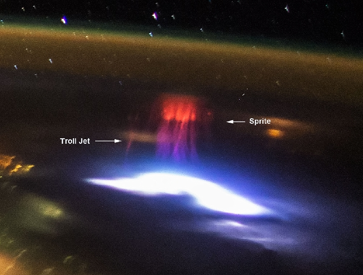
Esta otra, de lo que parece ser el HAARP en full mode, (para evitar el paso del ciclon sobre la isla) fue tomada por la estacion espacial internacional a su paso por nuestra area y se trata de la misma cosa...o sea, no el HAARP, sino los "sprites".
Que cosas verdad?
El escenario en general es feo, muy feo...Dios los proteja.
Nota al margen:
Imagenes de un fenomeno muy llamativo ocurrido sobre Puerto Rico tras el paso de Matthews al sur.
"Sprites" sobre el cielo de la isla__Son descargas electricas en la alta atmosfera cuya causa y detalle muy bien pudiera encontrar quien interese, guguleando la red o en Wikipedia.
Fueron tomadas por un tal Frankie Lucena de Cabo Rojo, a quien agradecemos y de quien nos tomamos la libertad de borrar su nombre de las fotos porque no aportaban absolutamente nada.
Las publico en el sitio de http://spaceweather.com/
Esta otra, de lo que parece ser el HAARP en full mode, (para evitar el paso del ciclon sobre la isla) fue tomada por la estacion espacial internacional a su paso por nuestra area y se trata de la misma cosa...o sea, no el HAARP, sino los "sprites".
Que cosas verdad?
Re: Huracán Matthew
Otra nota, completamente Off Topic, pero, de interes general porque parece una noticia seria y es buena, de manera que estamos aprovechando que todo el que entra a este sitio, viene a buscar informacion sobre este monstruo llamado Matthew y le llega esta informacion por el lao, que ya supongo saldra mas adelante en los noticieros y periodicos locales.
http://www.thetimes.co.uk/article/briti ... -w7zb86zw0
Es en ingles, pero, basicamente, lo que dice es que tan curando el SIDA!
http://www.thetimes.co.uk/article/briti ... -w7zb86zw0
Es en ingles, pero, basicamente, lo que dice es que tan curando el SIDA!

Re: Huracán Matthew
Saludos DavidDavid.79 wrote:Otra nota, completamente Off Topic, pero, de interes general porque parece una noticia seria y es buena, de manera que estamos aprovechando que todo el que entra a este sitio, viene a buscar informacion sobre este monstruo llamado Matthew y le llega esta informacion por el lao, que ya supongo saldra mas adelante en los noticieros y periodicos locales.
http://www.thetimes.co.uk/article/briti ... -w7zb86zw0
Es en ingles, pero, basicamente, lo que dice es que tan curando el SIDA!
Ayer en la noche estaba leyendo sobre esta gran noticia.
De verdad seria un gran logro si de verdad encuentran la cura de esta enfermedad que atormenta tanto a la humanidad.
-
StormWatch
- Cat. 3
- Posts: 3741
- Joined: Thu Aug 06, 2015 11:39 am
- Location: Texas, USA
Re: Huracán Matthew
At 2pm
000
WTNT34 KNHC 031750
TCPAT4
BULLETIN
HURRICANE MATTHEW INTERMEDIATE ADVISORY NUMBER 22A
NWS NATIONAL HURRICANE CENTER MIAMI FL AL142016
200 PM EDT MON OCT 03 2016
...DANGEROUS HURRICANE MATTHEW MOVING NORTHWARD...
...LIFE-THREATENING RAIN...WIND...AND STORM SURGE EXPECTED IN
PORTIONS OF HAITI...
SUMMARY OF 200 PM EDT...1800 UTC...INFORMATION
----------------------------------------------
LOCATION...15.9N 74.8W
ABOUT 250 MI...400 KM SW OF PORT AU PRINCE HAITI
ABOUT 195 MI...315 KM SE OF KINGSTON JAMAICA
MAXIMUM SUSTAINED WINDS...140 MPH...220 KM/H
PRESENT MOVEMENT...N OR 5 DEGREES AT 6 MPH...9 KM/H
MINIMUM CENTRAL PRESSURE...940 MB...27.76 INCHES
WATCHES AND WARNINGS
--------------------
CHANGES WITH THIS ADVISORY:
None.
SUMMARY OF WATCHES AND WARNINGS IN EFFECT:
A Hurricane Warning is in effect for...
* Jamaica
* Haiti
* Cuban provinces of Guantanamo, Santiago de Cuba, Holguin, Granma,
and Las Tunas
* Southeastern Bahamas, including the Inaguas, Mayaguana, Acklins,
Crooked Island, Long Cay, and Ragged Island
A Hurricane Watch is in effect for...
* Cuban province of Camaguey
* Turks and Caicos Islands
* Central Bahamas, including Long Island, Exuma, Rum Cay, San
Salvador, and Cat Island
A Tropical Storm Warning is in effect for...
* Dominican Republic from Barahona westward to the border with Haiti
A Tropical Storm Watch is in effect for...
* Dominican Republic from Puerto Plata westward to the border with
Haiti
Interests elsewhere in Hispaniola, the Bahamas, and in the Florida
Peninsula and the Florida Keys should monitor the progress of
Matthew.
For storm information specific to your area, please monitor products
issued by your national meteorological service.
DISCUSSION AND 48-HOUR OUTLOOK
------------------------------
At 200 PM EDT (1800 UTC), the eye of Hurricane Matthew was located
near latitude 15.9 North, longitude 74.8 West. Matthew is moving
toward the north near 6 mph (9 km/h), and this general motion is
forecast to continue through Wednesday with an increase in forward
speed expected tonight. On the forecast track, the center of
Matthew will approach southwestern Haiti tonight, move near eastern
Cuba late Tuesday, and move near or over portions of the
southeastern and central Bahamas Tuesday night and Wednesday.
Data from an Air Force Reserve Hurricane Hunter aircraft indicate
that maximum sustained winds are near 140 mph (220 km/h) with higher
gusts. Matthew is a dangerous category 4 hurricane on the Saffir-
Simpson Hurricane Wind Scale. Some fluctuations in intensity are
possible during the next couple of days, but Matthew is expected to
remain a powerful hurricane through Wednesday.
Hurricane-force winds extend outward up to 35 miles (55 km) from
the center and tropical-storm-force winds extend outward up to 185
miles (295 km).
The latest minimum central pressure based on data from the aircraft
is 940 mb (27.76 inches).
HAZARDS AFFECTING LAND
----------------------
WIND: Hurricane conditions are expected to first reach Haiti
tonight, eastern Cuba Tuesday, and the southeastern Bahamas late
Tuesday. Tropical storm conditions are expected to first reach
Haiti this afternoon, eastern Cuba tonight, and the southeastern
Bahamas early Tuesday, making outside preparations difficult or
dangerous. Preparations to protect life and property should be
rushed to completion.
Tropical storm conditions are expected in Jamaica and along the
southern coast of the Dominican Republic within the warning area
beginning today.
Hurricane conditions are possible in the hurricane watch areas by
Tuesday night with tropical storm conditions possible on Tuesday.
Tropical storm conditions are also possible in the tropical storm
watch area in the Dominican Republic by late today.
RAINFALL: Matthew is expected to produce total rainfall amounts in
the following areas:
Southern Haiti and southwestern Dominican Republic...15 to 25
inches, isolated 40 inches
Eastern Cuba and northwestern Haiti...8 to 12 inches, isolated
20 inches
Eastern Jamaica...5 to 10 inches, isolated 15 to 20 inches
Southeastern Bahamas...8 to 12 inches, isolated 15 inches
Turks and Caicos Islands...2 to 5 inches, isolated 8 inches
Northeastern Haiti and the Dominican Republic...1 to 3 inches,
isolated 5 inches
Western Jamaica...1 to 2 inches
Life-threatening flash floods and mudslides are likely from this
rainfall in southern and northwestern Haiti, the southwestern
Dominican Republic, and eastern Cuba.
STORM SURGE: The combination of a dangerous storm surge and large
and destructive waves could raise water levels by as much as the
following amounts above normal tide levels...
Southern Coast of Cuba east of Cabo Cruz...7 to 11 feet
South Coast of Haiti...7 to 10 feet
Northern Coast of Cuba east of Camaguey...4 to 6 feet
Jamaica...2 to 4 feet
Gulf of Gonave in Haiti...3 to 5 feet
Southern coast of the Dominican Republic...1 to 3 feet
Central and southeastern Bahamas...10 to 15 feet
Surge-related flooding depends on the relative timing of the surge
and the tidal cycle, and can vary greatly over short distances.
Large waves generated by Matthew will cause water rises to occur
well in advance of and well away from the track of the center.
SURF: Swells generated by Matthew will continue to affect portions
of the coasts of Hispaniola, Jamaica, Aruba, Colombia, eastern Cuba,
and the Caribbean coastline of Central America during the next few
days. Swells from Matthew will begin affecting portions of the
Bahamas on Tuesday. These swells are likely to cause life-
threatening surf and rip current conditions. Please consult
products from your local weather office.
NEXT ADVISORY
-------------
Next complete advisory at 500 PM EDT.
$$
Forecaster Brennan
Member Since 2005
For official information, please refer to NHC: https://www.nhc.noaa.gov
Hurricane’s hit Puerto Rico:
San Felipe 1928, San Ciprián 1932, Santa Clara 1956, Hugo 1989, Marilyn 1995, Hortense 1996, Georges 1998, Maria 2017, Fiona 2022
Model Runs:
GFS:
[5:30 AM/PM, 11:30 AM/PM]
HWRF, GFDL, UKMET, NAVGEM:
[6:30-8:00 AM/PM, 12:30-2:00 AM/PM]
ECMWF:
[1:45 AM/PM]
For official information, please refer to NHC: https://www.nhc.noaa.gov
Hurricane’s hit Puerto Rico:
San Felipe 1928, San Ciprián 1932, Santa Clara 1956, Hugo 1989, Marilyn 1995, Hortense 1996, Georges 1998, Maria 2017, Fiona 2022
Model Runs:
GFS:
[5:30 AM/PM, 11:30 AM/PM]
HWRF, GFDL, UKMET, NAVGEM:
[6:30-8:00 AM/PM, 12:30-2:00 AM/PM]
ECMWF:
[1:45 AM/PM]

Re: Huracán Matthew
Ustedes se han fijado como que los modelos tratan de hacer algo con el sistema cerca de los 45w???
llevan ya vaaaaaarias corridas
llevan ya vaaaaaarias corridas
-
Laniña2016
- Invest

- Posts: 212
- Joined: Sat May 28, 2016 7:19 am
Re: Huracán Matthew
¿Qué hace?Arlequín wrote:Ustedes se han fijado como que los modelos tratan de hacer algo con el sistema cerca de los 45w???
llevan ya vaaaaaarias corridas
-
StormWatch
- Cat. 3
- Posts: 3741
- Joined: Thu Aug 06, 2015 11:39 am
- Location: Texas, USA
Re: Huracán Matthew
Imagen actual!
Si por lo menos sus vientos bajaran a 110 o menos, lo q sera catastrofico es su velocidad de traslación ... Esta fuerte eso!

Si por lo menos sus vientos bajaran a 110 o menos, lo q sera catastrofico es su velocidad de traslación ... Esta fuerte eso!
Member Since 2005
For official information, please refer to NHC: https://www.nhc.noaa.gov
Hurricane’s hit Puerto Rico:
San Felipe 1928, San Ciprián 1932, Santa Clara 1956, Hugo 1989, Marilyn 1995, Hortense 1996, Georges 1998, Maria 2017, Fiona 2022
Model Runs:
GFS:
[5:30 AM/PM, 11:30 AM/PM]
HWRF, GFDL, UKMET, NAVGEM:
[6:30-8:00 AM/PM, 12:30-2:00 AM/PM]
ECMWF:
[1:45 AM/PM]
For official information, please refer to NHC: https://www.nhc.noaa.gov
Hurricane’s hit Puerto Rico:
San Felipe 1928, San Ciprián 1932, Santa Clara 1956, Hugo 1989, Marilyn 1995, Hortense 1996, Georges 1998, Maria 2017, Fiona 2022
Model Runs:
GFS:
[5:30 AM/PM, 11:30 AM/PM]
HWRF, GFDL, UKMET, NAVGEM:
[6:30-8:00 AM/PM, 12:30-2:00 AM/PM]
ECMWF:
[1:45 AM/PM]
Re: Huracán Matthew
El EURO el HWRF el GFDL NAVGEMLaniña2016 wrote:¿Qué hace?Arlequín wrote:Ustedes se han fijado como que los modelos tratan de hacer algo con el sistema cerca de los 45w???
llevan ya vaaaaaarias corridas
muestran algo atravesando las antillas a menos de 4 dias
-
StormWatch
- Cat. 3
- Posts: 3741
- Joined: Thu Aug 06, 2015 11:39 am
- Location: Texas, USA
Re: Huracán Matthew
Arlequín wrote:El EURO el HWRF el GFDL NAVGEMLaniña2016 wrote:¿Qué hace?Arlequín wrote:Ustedes se han fijado como que los modelos tratan de hacer algo con el sistema cerca de los 45w???
llevan ya vaaaaaarias corridas
muestran algo atravesando las antillas a menos de 4 dias
Hmmmmmmmmmmmm!
Member Since 2005
For official information, please refer to NHC: https://www.nhc.noaa.gov
Hurricane’s hit Puerto Rico:
San Felipe 1928, San Ciprián 1932, Santa Clara 1956, Hugo 1989, Marilyn 1995, Hortense 1996, Georges 1998, Maria 2017, Fiona 2022
Model Runs:
GFS:
[5:30 AM/PM, 11:30 AM/PM]
HWRF, GFDL, UKMET, NAVGEM:
[6:30-8:00 AM/PM, 12:30-2:00 AM/PM]
ECMWF:
[1:45 AM/PM]
For official information, please refer to NHC: https://www.nhc.noaa.gov
Hurricane’s hit Puerto Rico:
San Felipe 1928, San Ciprián 1932, Santa Clara 1956, Hugo 1989, Marilyn 1995, Hortense 1996, Georges 1998, Maria 2017, Fiona 2022
Model Runs:
GFS:
[5:30 AM/PM, 11:30 AM/PM]
HWRF, GFDL, UKMET, NAVGEM:
[6:30-8:00 AM/PM, 12:30-2:00 AM/PM]
ECMWF:
[1:45 AM/PM]