
Invest 92L al Sur de Florida (Anaranjado 40%-40%)

Re: Invest 92L- 10-20% de posibilidades de desarrollo
Alberto ya que te veo por ahí podrías cambiarle los números de desarrollo a este pobre y abatido invest 92L . Jajaja

Re: Invest 92L- 20/30% de posibilidades de desarrollo
Se me hace difícil localizar algún Low...
-
huracan sur
- Depresión Tropical

- Posts: 400
- Joined: Wed Sep 04, 2013 3:26 am
Re: Invest 92L- 20/30% de posibilidades de desarrollo
Para información oficial favor referirse a las agencias pertinentes. Un aficionado a la meteorología #TeamCycloforums
Re: Invest 92L- 20/30% de posibilidades de desarrollo
Esto iba aquí,...
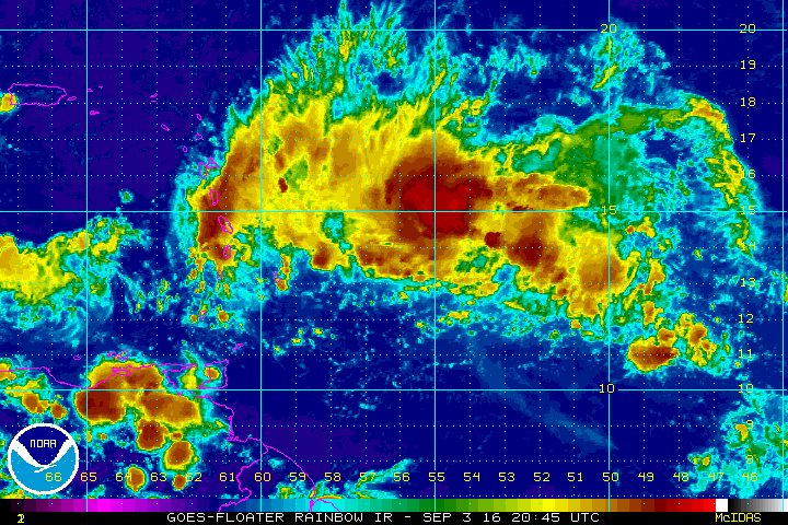
A tropical wave, accompanied by a broad area of low pressure, is
located about 250 miles east the Lesser Antilles. This system
continues to produce a large area of cloudiness and showers, and is
likely producing winds to near tropical storm force. Upper-level
winds are forecast to become less conducive for any significant
development of this disturbance while it moves westward at 15 to 20
mph through the Caribbean Sea this week. Regardless of development,
this disturbance will produce locally heavy rainfall and gusty
winds, possibly to tropical storm force, over portions of the
Lesser Antilles this afternoon through early Monday.
* Formation chance through 48 hours...low...20 percent
* Formation chance through 5 days...low...30 percent
Re: Invest 92L- 20/30% de posibilidades de desarrollo
modelos 2 am lo ponen rosando sur de PR, no c poner imagenes aqui
-
ROCKstormSJ4315

- Tormenta Tropical

- Posts: 888
- Joined: Tue Aug 06, 2013 10:09 pm
- Location: Hato Rey, San Juan, PR
Re: Invest 92L- 20/30% de posibilidades de desarrollo
Tal como comenta el companero, no se donde aparecen los modelos, pues no confio mucho en ellos, pero antes tambien comente que no me extranaria que las nuevas corridas agruparan la posible trayectoria del Invest mas cerca de PR.
Tambien en otra pagina del tiempo los veo colocando al Invest 92 rozando o quizas entrando por la costa sur.
Ya los amigos foristas mas tarde podran postear los mismos para que quede mas claro.
Tambien en otra pagina del tiempo los veo colocando al Invest 92 rozando o quizas entrando por la costa sur.
Ya los amigos foristas mas tarde podran postear los mismos para que quede mas claro.
"Georgy Girl", The Seekers
"Back for Good", Take That
"Perfectionist", SAGA
"Graves Into Gardens", Elevation Worship ft. Brandon Lake
"Thunder", Imagine Dragons
"Viva la Vida", Coldplay
"Back for Good", Take That
"Perfectionist", SAGA
"Graves Into Gardens", Elevation Worship ft. Brandon Lake
"Thunder", Imagine Dragons
"Viva la Vida", Coldplay
Re: Invest 92L- 20/30% de posibilidades de desarrollo
1. A tropical wave, accompanied by a broad area of low pressure, is
located about 250 miles east the Lesser Antilles. This system
continues to produce a large area of cloudiness and showers, and is
likely producing winds to near tropical storm force. Upper-level
winds are forecast to become less conducive for any significant
development of this disturbance while it moves westward at 15 to 20
mph through the Caribbean Sea this week. Regardless of development,
this disturbance will produce locally heavy rainfall and gusty
winds, possibly to tropical storm force, over portions of the
Lesser Antilles this afternoon through early Monday.
* Formation chance through 48 hours...low...20 percent
* Formation chance through 5 days...low...30 percent
Re: Invest 92L- 20/30% de posibilidades de desarrollo
000
ABNT20 KNHC 041127
TWOAT
TROPICAL WEATHER OUTLOOK
NWS NATIONAL HURRICANE CENTER MIAMI FL
800 AM EDT SUN SEP 4 2016
For the North Atlantic...Caribbean Sea and the Gulf of Mexico:
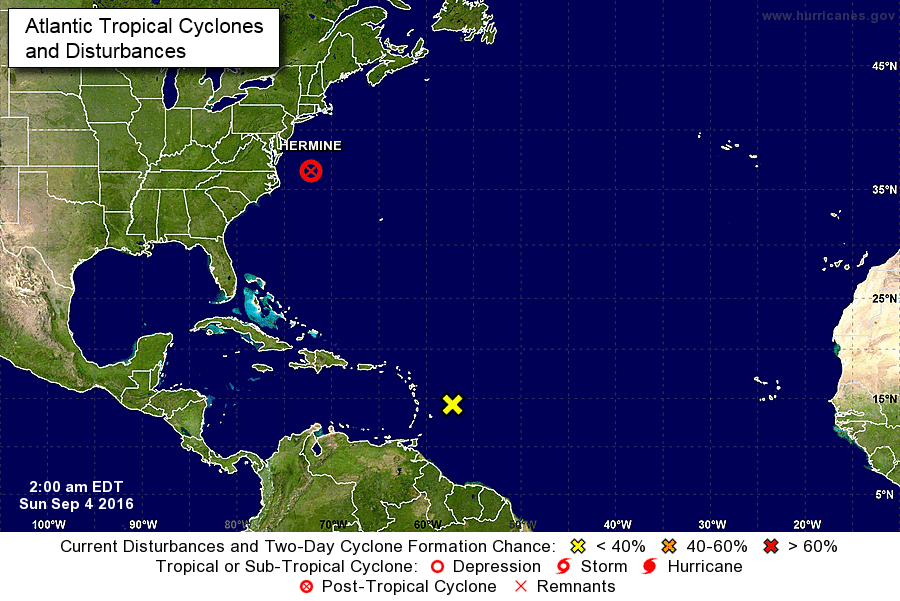
The National Hurricane Center is issuing advisories on Post-Tropical
Cyclone Hermine, located off of the mid-Atlantic coast of the United
States.
A tropical wave located just east of the Lesser Antilles is
producing a large area of cloudiness and showers and winds to near
tropical storm force. Upper-level winds are not expected to be
conducive for significant development of this disturbance while it
moves westward at 15 to 20 mph through the Caribbean Sea this week.
Regardless of whether or not development occurs, this wave will
produce locally heavy rainfall and gusty winds over portions of the
Lesser Antilles through early Monday.
* Formation chance through 48 hours...low...20 percent
* Formation chance through 5 days...low...30 percent
$$
Forecaster Cangialosi
ABNT20 KNHC 041127
TWOAT
TROPICAL WEATHER OUTLOOK
NWS NATIONAL HURRICANE CENTER MIAMI FL
800 AM EDT SUN SEP 4 2016
For the North Atlantic...Caribbean Sea and the Gulf of Mexico:
The National Hurricane Center is issuing advisories on Post-Tropical
Cyclone Hermine, located off of the mid-Atlantic coast of the United
States.
A tropical wave located just east of the Lesser Antilles is
producing a large area of cloudiness and showers and winds to near
tropical storm force. Upper-level winds are not expected to be
conducive for significant development of this disturbance while it
moves westward at 15 to 20 mph through the Caribbean Sea this week.
Regardless of whether or not development occurs, this wave will
produce locally heavy rainfall and gusty winds over portions of the
Lesser Antilles through early Monday.
* Formation chance through 48 hours...low...20 percent
* Formation chance through 5 days...low...30 percent
$$
Forecaster Cangialosi
-
huracan_1975
- Tormenta Tropical
- Posts: 630
- Joined: Sun Aug 16, 2015 9:59 am
Re: Invest 92L- 20/30% de posibilidades de desarrollo
nuevo centro relocalizado
Information as of the most recent model cycle ?
At 0600 UTC, 04 September 2016, LOW INVEST (AL92) was located in the North Atlantic basin at 14.4°N and 56.7°W. The current intensity was 30 kt and the center was moving at 19 kt at a bearing of 275 degrees. The minimum central pressure was 1007 mb.
modelos de intensidad y trayectoria 06z.
http://www.ral.ucar.edu/guidance/realti ... /al922016/