Aquí encontrarás todo lo relacionado al la meteorología en Puerto Rico y las condiciones del tiempo actuales, así como los huracanes que se desarrollen durante las temporadas ciclónicas, actualizados por expertos y aficionados a la meteorología de todo el pais! Este es tu foro! Leelo, escribe en el y disfrútalo! Cycloman.
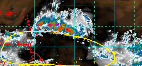
A tropical wave located about 450 miles east of the Lesser Antilles
continues to produce a large area of disorganized showers and
thunderstorms. Environmental conditions are only marginally
conducive, and any development of this system should be slow to
occur while it moves westward at 15 to 20 mph. This disturbance is
expected to bring locally heavy rainfall and gusty winds to portions
of the Lesser Antilles beginning later today through Sunday night.
* Formation chance through 48 hours...low...20 percent
* Formation chance through 5 days...low...30 percent
Hurricane’s hit Puerto Rico: San Felipe 1928, San Ciprián 1932, Santa Clara 1956, Hugo 1989, Marilyn 1995, Hortense 1996, Georges 1998, Maria 2017, Fiona 2022
boya cerca del invest 92L... reporte 2:30 pm .. vientos sostenido de 30 mph, ráfagas de casi 33 mph .. presión 29.79 = 1008 mlb
Conditions at 41040 as of
(2:50 pm ADT)
1750 GMT on 09/03/2016:
Unit of Measure: Time Zone: Select
Click on the graph icon in the table below to see a time series plot of the last five days of that observation.
5-day plot - Wind Direction Wind Direction (WDIR): E ( 90 deg true )
5-day plot - Wind Speed Wind Speed (WSPD): 23.3 kts
5-day plot - Wind Gust Wind Gust (GST): 27.2 kts
5-day plot - Wave Height Wave Height (WVHT): 9.8 ft
5-day plot - Dominant Wave Period Dominant Wave Period (DPD): 8 sec
5-day plot - Average Period Average Period (APD): 6.3 sec
5-day plot - Mean Wave Direction Mean Wave Direction (MWD): ENE ( 72 deg true )
5-day plot - Atmospheric Pressure Atmospheric Pressure (PRES): 29.79 in 5-day plot - Pressure Tendency Pressure Tendency (PTDY): -0.05 in ( Falling )
5-day plot - Air Temperature Air Temperature (ATMP): 81.3 °F
5-day plot - Water Temperature Water Temperature (WTMP): 83.7 °F
5-day plot - Dew Point Dew Point (DEWP): 77.2 °F
5-day plot - Heat Index Heat Index (HEAT): 88.7 °F 5-day plot - Wind Speed at 10 Meters Wind Speed at 10 meters (WSPD10M): 25.3 kts
5-day plot - Wind Speed at 10 Meters Wind Speed at 20 meters (WSPD20M): 27.2 kts
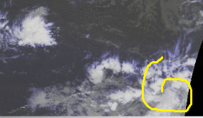
David.79 wrote:92L es el invest mas feo que hemos visto en mucho tiempo.
Si embargo la apriencia engana esta mas saludable de lo que parece.
Es una pena que hoy y desde la medianoche le quitaron la alfombra de los pies, nada al sur de lo que el pueda alimentarse, suprimieron, hasta nuevo aviso la ITCZ y no le queda mucho combustible por quemar...pero ahi va
Por cierto, esa zona mas a la derecha, al suroeste de Cabo Verde parece que intenta levantarse, ha ganado circulacion en los ultimos frames del satelite, si persisten esas tronadas pudieramos sacar un low mas adelante cerca a la 10n que es una latitud bastante atractiva
No hay mucho mas. vendran dias mejores...supongo.
Totalmente de acuerdo en lo de lo feo
y ciertamente tambien esta como la arepa.... candela por arriba y candela por abajo
At 1800 UTC, 03 September 2016, TROPICAL WAVE INVEST (AL92) was located in the North Atlantic basin at 13.6°N and 53.7°W. The current intensity was 30 kt and the center was moving at 21 kt at a bearing of 275 degrees. The minimum central pressure was 1008 mb.
boya 41040, presión bajando .... ahora en 1007 mlb bajo 1 milibar en una hora . vientos sostenido en 33 mph , ráfagas en 36 mph ,
Conditions at 41040 as of
(3:50 pm ADT)
1850 GMT on 09/03/2016:
Unit of Measure: Time Zone: Select
Click on the graph icon in the table below to see a time series plot of the last five days of that observation.
5-day plot - Wind Direction Wind Direction (WDIR): E ( 90 deg true ) 5-day plot - Wind Speed Wind Speed (WSPD): 25.3 kts
5-day plot - Wind Gust Wind Gust (GST): 29.1 kts
5-day plot - Wave Height Wave Height (WVHT): 10.5 ft
5-day plot - Dominant Wave Period Dominant Wave Period (DPD): 8 sec
5-day plot - Average Period Average Period (APD): 6.3 sec
5-day plot - Mean Wave Direction Mean Wave Direction (MWD): ENE ( 70 deg true ) 5-day plot - Atmospheric Pressure Atmospheric Pressure (PRES): 29.77 in 5-day plot - Pressure Tendency Pressure Tendency (PTDY): -0.06 in ( Falling )
5-day plot - Air Temperature Air Temperature (ATMP): 81.0 °F
5-day plot - Water Temperature Water Temperature (WTMP): 83.7 °F
5-day plot - Dew Point Dew Point (DEWP): 76.1 °F
5-day plot - Heat Index Heat Index (HEAT): 87.4 °F 5-day plot - Wind Speed at 10 Meters Wind Speed at 10 meters (WSPD10M): 27.2 kts
5-day plot - Wind Speed at 10 Meters Wind Speed at 20 meters (WSPD20M): 29.1 kts
Last edited by huracan_1975 on Sat Sep 03, 2016 3:24 pm, edited 2 times in total.
Muy interesante presión bajando y los modelos de las 18Z tienen al sistema más fuerte poco a poco. Lo que no me gusta es q subió su velocidad de traslación siempre algo malo
Javier wrote:Muy interesante presión bajando y los modelos de las 18Z tienen al sistema más fuerte poco a poco. Lo que no me gusta es q subió su velocidad de traslación siempre algo malo
algo bueno, parece q x eso los modelos se alinearon mas cerca de PR, sera pq ven q se fortaleze un poco, x lo menos con algo de lluvia me conformo...


