
Huracan GASTON - Atlantico central
-
StormWatch
- Cat. 3

- Posts: 3721
- Joined: Thu Aug 06, 2015 11:39 am
- Location: Texas, USA
Re: Tormenta Tropical GASTON - Atlantico Oriental
Adios amigo! #Gaston
Member Since 2005
For official information, please refer to NHC: https://www.nhc.noaa.gov
Hurricane’s hit Puerto Rico:
San Felipe 1928, San Ciprián 1932, Santa Clara 1956, Hugo 1989, Marilyn 1995, Hortense 1996, Georges 1998, Maria 2017, Fiona 2022
Model Runs:
GFS:
[5:30 AM/PM, 11:30 AM/PM]
HWRF, GFDL, UKMET, NAVGEM:
[6:30-8:00 AM/PM, 12:30-2:00 AM/PM]
ECMWF:
[1:45 AM/PM]
-
StormWatch
- Cat. 3
- Posts: 3721
- Joined: Thu Aug 06, 2015 11:39 am
- Location: Texas, USA
Re: Tormenta Tropical GASTON - Atlantico Oriental
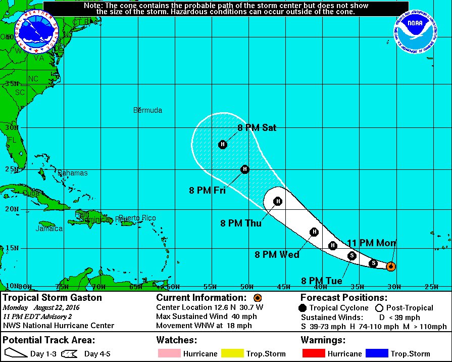
000
WTNT32 KNHC 230840
TCPAT2
BULLETIN
TROPICAL STORM GASTON ADVISORY NUMBER 3
NWS NATIONAL HURRICANE CENTER MIAMI FL AL072016
500 AM AST TUE AUG 23 2016
...GASTON STRENGTHENS OVER THE FAR EASTERN TROPICAL ATLANTIC...
SUMMARY OF 500 AM AST...0900 UTC...INFORMATION
----------------------------------------------
LOCATION...13.2N 32.4W
ABOUT 545 MI...880 KM W OF THE SOUTHERNMOST CABO VERDE ISLANDS
MAXIMUM SUSTAINED WINDS...50 MPH...85 KM/H
PRESENT MOVEMENT...WNW OR 290 DEGREES AT 20 MPH...31 KM/H
MINIMUM CENTRAL PRESSURE...1004 MB...29.65 INCHES
WATCHES AND WARNINGS
--------------------
There are no coastal watches or warnings in effect.
DISCUSSION AND 48-HOUR OUTLOOK
------------------------------
At 500 AM AST (0900 UTC), the center of Tropical Storm Gaston was
located near latitude 13.2 North, longitude 32.4 West. Gaston is
moving toward the west-northwest near 20 mph (31 km/h) and this
general motion with a slight decrease in forward speed is expected
during the next couple of days.
Maximum sustained winds have increased to near 50 mph (85 km/h) with
higher gusts. Additional strengthening is forecast, and Gaston
is expected to become a hurricane by Wednesday.
Tropical-storm-force winds extend outward up to 60 miles (95 km)
from the center.
The estimated minimum central pressure is 1004 mb (29.65 inches).
HAZARDS AFFECTING LAND
----------------------
None.
NEXT ADVISORY
-------------
Next complete advisory at 1100 AM AST.
$$
Forecaster Stewart
Member Since 2005
For official information, please refer to NHC: https://www.nhc.noaa.gov
Hurricane’s hit Puerto Rico:
San Felipe 1928, San Ciprián 1932, Santa Clara 1956, Hugo 1989, Marilyn 1995, Hortense 1996, Georges 1998, Maria 2017, Fiona 2022
Model Runs:
GFS:
[5:30 AM/PM, 11:30 AM/PM]
HWRF, GFDL, UKMET, NAVGEM:
[6:30-8:00 AM/PM, 12:30-2:00 AM/PM]
ECMWF:
[1:45 AM/PM]
For official information, please refer to NHC: https://www.nhc.noaa.gov
Hurricane’s hit Puerto Rico:
San Felipe 1928, San Ciprián 1932, Santa Clara 1956, Hugo 1989, Marilyn 1995, Hortense 1996, Georges 1998, Maria 2017, Fiona 2022
Model Runs:
GFS:
[5:30 AM/PM, 11:30 AM/PM]
HWRF, GFDL, UKMET, NAVGEM:
[6:30-8:00 AM/PM, 12:30-2:00 AM/PM]
ECMWF:
[1:45 AM/PM]
-
StormWatch
- Cat. 3
- Posts: 3721
- Joined: Thu Aug 06, 2015 11:39 am
- Location: Texas, USA
Re: Tormenta Tropical GASTON - Atlantico Oriental
Hey #Gaston
Member Since 2005
For official information, please refer to NHC: https://www.nhc.noaa.gov
Hurricane’s hit Puerto Rico:
San Felipe 1928, San Ciprián 1932, Santa Clara 1956, Hugo 1989, Marilyn 1995, Hortense 1996, Georges 1998, Maria 2017, Fiona 2022
Model Runs:
GFS:
[5:30 AM/PM, 11:30 AM/PM]
HWRF, GFDL, UKMET, NAVGEM:
[6:30-8:00 AM/PM, 12:30-2:00 AM/PM]
ECMWF:
[1:45 AM/PM]
For official information, please refer to NHC: https://www.nhc.noaa.gov
Hurricane’s hit Puerto Rico:
San Felipe 1928, San Ciprián 1932, Santa Clara 1956, Hugo 1989, Marilyn 1995, Hortense 1996, Georges 1998, Maria 2017, Fiona 2022
Model Runs:
GFS:
[5:30 AM/PM, 11:30 AM/PM]
HWRF, GFDL, UKMET, NAVGEM:
[6:30-8:00 AM/PM, 12:30-2:00 AM/PM]
ECMWF:
[1:45 AM/PM]
-
StormWatch
- Cat. 3
- Posts: 3721
- Joined: Thu Aug 06, 2015 11:39 am
- Location: Texas, USA
Re: Tormenta Tropical GASTON - Atlantico Oriental
Uno asi en la 17 y 64 

Member Since 2005
For official information, please refer to NHC: https://www.nhc.noaa.gov
Hurricane’s hit Puerto Rico:
San Felipe 1928, San Ciprián 1932, Santa Clara 1956, Hugo 1989, Marilyn 1995, Hortense 1996, Georges 1998, Maria 2017, Fiona 2022
Model Runs:
GFS:
[5:30 AM/PM, 11:30 AM/PM]
HWRF, GFDL, UKMET, NAVGEM:
[6:30-8:00 AM/PM, 12:30-2:00 AM/PM]
ECMWF:
[1:45 AM/PM]
For official information, please refer to NHC: https://www.nhc.noaa.gov
Hurricane’s hit Puerto Rico:
San Felipe 1928, San Ciprián 1932, Santa Clara 1956, Hugo 1989, Marilyn 1995, Hortense 1996, Georges 1998, Maria 2017, Fiona 2022
Model Runs:
GFS:
[5:30 AM/PM, 11:30 AM/PM]
HWRF, GFDL, UKMET, NAVGEM:
[6:30-8:00 AM/PM, 12:30-2:00 AM/PM]
ECMWF:
[1:45 AM/PM]
-
StormWatch
- Cat. 3
- Posts: 3721
- Joined: Thu Aug 06, 2015 11:39 am
- Location: Texas, USA
Re: Tormenta Tropical GASTON - Atlantico Oriental
000
WTNT32 KNHC 231435
TCPAT2
BULLETIN
TROPICAL STORM GASTON ADVISORY NUMBER 4
NWS NATIONAL HURRICANE CENTER MIAMI FL AL072016
1100 AM AST TUE AUG 23 2016
...GASTON STILL STRENGTHENING WHILE MOVING QUICKLY
WEST-NORTHWESTWARD...
SUMMARY OF 1100 AM AST...1500 UTC...INFORMATION
-----------------------------------------------
LOCATION...13.8N 34.6W
ABOUT 685 MI...1105 KM W OF THE SOUTHERNMOST CABO VERDE ISLANDS
MAXIMUM SUSTAINED WINDS...65 MPH...100 KM/H
PRESENT MOVEMENT...WNW OR 285 DEGREES AT 21 MPH...33 KM/H
MINIMUM CENTRAL PRESSURE...1002 MB...29.59 INCHES
WATCHES AND WARNINGS
--------------------
There are no coastal watches or warnings in effect.
DISCUSSION AND 48-HOUR OUTLOOK
------------------------------
At 1100 AM AST (1500 UTC), the center of Tropical Storm Gaston was
located near latitude 13.8 North, longitude 34.6 West. Gaston is
moving toward the west-northwest near 21 mph (33 km/h). A gradual
turn toward the northwest is expected during the next couple of
days with a decrease in forward speed.
Maximum sustained winds have increased to near 65 mph (100 km/h)
with higher gusts. Additional strengthening is likely, and Gaston
should become a hurricane later today.
Tropical-storm-force winds extend outward up to 70 miles (110 km)
from the center.
The estimated minimum central pressure is 1002 mb (29.59 inches).
HAZARDS AFFECTING LAND
----------------------
None.
NEXT ADVISORY
-------------
Next complete advisory at 500 PM AST.
$$
Forecaster Kimberlain
Member Since 2005
For official information, please refer to NHC: https://www.nhc.noaa.gov
Hurricane’s hit Puerto Rico:
San Felipe 1928, San Ciprián 1932, Santa Clara 1956, Hugo 1989, Marilyn 1995, Hortense 1996, Georges 1998, Maria 2017, Fiona 2022
Model Runs:
GFS:
[5:30 AM/PM, 11:30 AM/PM]
HWRF, GFDL, UKMET, NAVGEM:
[6:30-8:00 AM/PM, 12:30-2:00 AM/PM]
ECMWF:
[1:45 AM/PM]
For official information, please refer to NHC: https://www.nhc.noaa.gov
Hurricane’s hit Puerto Rico:
San Felipe 1928, San Ciprián 1932, Santa Clara 1956, Hugo 1989, Marilyn 1995, Hortense 1996, Georges 1998, Maria 2017, Fiona 2022
Model Runs:
GFS:
[5:30 AM/PM, 11:30 AM/PM]
HWRF, GFDL, UKMET, NAVGEM:
[6:30-8:00 AM/PM, 12:30-2:00 AM/PM]
ECMWF:
[1:45 AM/PM]


Re: Tormenta Tropical GASTON - Atlantico Oriental
BULLETIN
TROPICAL STORM GASTON ADVISORY NUMBER 5
NWS NATIONAL HURRICANE CENTER MIAMI FL AL072016
500 PM AST TUE AUG 23 2016
...GASTON EXPECTED TO BECOME A HURRICANE BY WEDNESDAY...
SUMMARY OF 500 PM AST...2100 UTC...INFORMATION
----------------------------------------------
LOCATION...14.2N 35.8W
ABOUT 765 MI...1230 KM W OF THE SOUTHERNMOST CABO VERDE ISLANDS
MAXIMUM SUSTAINED WINDS...65 MPH...100 KM/H
PRESENT MOVEMENT...WNW OR 290 DEGREES AT 18 MPH...30 KM/H
MINIMUM CENTRAL PRESSURE...1002 MB...29.59 INCHES
WATCHES AND WARNINGS
--------------------
There are no coastal watches or warnings in effect.
DISCUSSION AND 48-HOUR OUTLOOK
------------------------------
At 500 PM AST (2100 UTC), the center of Tropical Storm Gaston was
located near latitude 14.2 North, longitude 35.8 West. Gaston is
moving toward the west-northwest near 18 mph (30 km/h). A gradual
turn toward the northwest is forecast during the next couple of
days with a decrease in forward speed.
Maximum sustained winds remain near 65 mph (100 km/h) with higher
gusts. Additional strengthening is likely, and Gaston should become
a hurricane later tonight or early Wednesday.
Tropical-storm-force winds extend outward up to 70 miles (110 km)
from the center.
The estimated minimum central pressure is 1002 mb (29.59 inches).
HAZARDS AFFECTING LAND
----------------------
None.
NEXT ADVISORY
-------------
Next complete advisory at 1100 PM AST.
$$
Forecaster Blake
TROPICAL STORM GASTON DISCUSSION NUMBER 5
NWS NATIONAL HURRICANE CENTER MIAMI FL AL072016
500 PM AST TUE AUG 23 2016
The cloud pattern of Gaston has not changed much during the past
several hours, although perhaps the convection has become more
symmetric. Satellite classifications are about the same as before,
so the initial wind speed remains 55 kt. Gaston has about 24-36
hours to intensify before southwesterly vertical wind shear
associated with a mid-tropospheric trough is forecast to increase.
This shear should result in some weakening of the cyclone in the
2 or 3 day time frame. Thereafter, Gaston moves away from the
trough, and since the cyclone should be over warm waters near 29C,
some restrengthing is likely. Considering the complexity of the
scenario, the guidance is in relatively good agreement on this
pattern. The official forecast follows the trend of the previous
forecast and the intensity consensus.
The initial motion estimate is 290/16. Gaston should gradually turn
northwestward during the next couple of days as it moves around the
subtropical ridge. Guidance is in very good agreement on the
forecast during that time, and little change is made to the
previous NHC track in the shorter term. Beyond 3 days, a break in
the subtropical ridge is forecast, although the models are not in
great agreement on exactly what longitude Gaston reaches before its
likely recurvature. Overall, the model guidance has shifted a bit
westward, and the latest NHC track forecast is shifted in that
direction.
FORECAST POSITIONS AND MAX WINDS
INIT 23/2100Z 14.2N 35.8W 55 KT 65 MPH
12H 24/0600Z 15.2N 38.1W 65 KT 75 MPH
24H 24/1800Z 16.8N 40.7W 75 KT 85 MPH
36H 25/0600Z 18.7N 43.2W 80 KT 90 MPH
48H 25/1800Z 20.8N 45.4W 80 KT 90 MPH
72H 26/1800Z 25.5N 49.6W 70 KT 80 MPH
96H 27/1800Z 28.5N 53.5W 75 KT 85 MPH
120H 28/1800Z 31.0N 54.5W 85 KT 100 MPH
$$
Forecaster Blake
Re: Tormenta Tropical GASTON - Atlantico Oriental
TROPICAL STORM GASTON ADVISORY NUMBER 6
NWS NATIONAL HURRICANE CENTER MIAMI FL AL072016
1100 PM AST TUE AUG 23 2016
...GASTON STILL EXPECTED TO BECOME A HURRICANE ON WEDNESDAY...
SUMMARY OF 1100 PM AST...0300 UTC...INFORMATION
-----------------------------------------------
LOCATION...14.7N 37.1W
ABOUT 875 MI...1410 KM W OF THE CABO VERDE ISLANDS
MAXIMUM SUSTAINED WINDS...65 MPH...100 KM/H
PRESENT MOVEMENT...WNW OR 290 DEGREES AT 17 MPH...28 KM/H
MINIMUM CENTRAL PRESSURE...1002 MB...29.59 INCHES
WATCHES AND WARNINGS
--------------------
There are no coastal watches or warnings in effect.
DISCUSSION AND 48-HOUR OUTLOOK
------------------------------
At 1100 PM AST (0300 UTC), the center of Tropical Storm Gaston was
located near latitude 14.7 North, longitude 37.1 West. Gaston is
moving toward the west-northwest near 17 mph (28 km/h). A gradual
turn toward the northwest is forecast over the next 48 hours.
Maximum sustained winds are near 65 mph (100 km/h) with higher
gusts. Strengthening is forecast during the next couple of days,
and Gaston is likely to become a hurricane on Wednesday.
Tropical-storm-force winds extend outward up to 70 miles (110 km)
from the center.
The estimated minimum central pressure is 1002 mb (29.59 inches).
HAZARDS AFFECTING LAND
----------------------
None.
NEXT ADVISORY
-------------
Next complete advisory at 500 AM AST.
$$
Forecaster Pasch
TROPICAL STORM GASTON DISCUSSION NUMBER 6
NWS NATIONAL HURRICANE CENTER MIAMI FL AL072016
1100 PM AST TUE AUG 23 2016
Gaston's cloud pattern has a figure-nine appearance, with an
apparent dry slot over the southwest quadrant, and lacks a
well-defined CDO at this time. The intensity is held at 55 kt in
agreement with subjective and objective Dvorak estimates. The
system has fairly well-defined upper-level outflow and is expected
to remain in a low-shear environment for the next day or so.
Therefore, the cyclone is likely to intensify into a hurricane in 12
to 24 hours. In about 36 hours, however, Gaston should encounter
increasing southwesterly shear associated with an upper-tropospheric
trough near 50-55W. This should at least temporarily halt the
intensification process, and probably cause a little weakening.
The global models indicate that Gaston will pass by the trough in 72
hours, and reintensification should commence around that time. The
official intensity forecast is near the high end of the guidance
models through 72 hours, and close to the model consensus
thereafter.
The motion continues toward the west-northwest, or 290/15 kt.
Gaston should gradually turn toward the northwest in response to a
break in the subtropical ridge near 60W. The official track
forecast, which is very similar to the previous one, follows the
latest dynamical model consensus, TVCN.
FORECAST POSITIONS AND MAX WINDS
INIT 24/0300Z 14.7N 37.1W 55 KT 65 MPH
12H 24/1200Z 15.8N 39.2W 65 KT 75 MPH
24H 25/0000Z 17.5N 41.7W 70 KT 80 MPH
36H 25/1200Z 19.5N 44.1W 75 KT 85 MPH
48H 26/0000Z 22.0N 46.2W 75 KT 85 MPH
72H 27/0000Z 26.5N 51.0W 70 KT 80 MPH
96H 28/0000Z 29.5N 54.5W 75 KT 85 MPH
120H 29/0000Z 31.5N 55.0W 85 KT 100 MPH
$$
Forecaster Pasch
NWS NATIONAL HURRICANE CENTER MIAMI FL AL072016
1100 PM AST TUE AUG 23 2016
...GASTON STILL EXPECTED TO BECOME A HURRICANE ON WEDNESDAY...
SUMMARY OF 1100 PM AST...0300 UTC...INFORMATION
-----------------------------------------------
LOCATION...14.7N 37.1W
ABOUT 875 MI...1410 KM W OF THE CABO VERDE ISLANDS
MAXIMUM SUSTAINED WINDS...65 MPH...100 KM/H
PRESENT MOVEMENT...WNW OR 290 DEGREES AT 17 MPH...28 KM/H
MINIMUM CENTRAL PRESSURE...1002 MB...29.59 INCHES
WATCHES AND WARNINGS
--------------------
There are no coastal watches or warnings in effect.
DISCUSSION AND 48-HOUR OUTLOOK
------------------------------
At 1100 PM AST (0300 UTC), the center of Tropical Storm Gaston was
located near latitude 14.7 North, longitude 37.1 West. Gaston is
moving toward the west-northwest near 17 mph (28 km/h). A gradual
turn toward the northwest is forecast over the next 48 hours.
Maximum sustained winds are near 65 mph (100 km/h) with higher
gusts. Strengthening is forecast during the next couple of days,
and Gaston is likely to become a hurricane on Wednesday.
Tropical-storm-force winds extend outward up to 70 miles (110 km)
from the center.
The estimated minimum central pressure is 1002 mb (29.59 inches).
HAZARDS AFFECTING LAND
----------------------
None.
NEXT ADVISORY
-------------
Next complete advisory at 500 AM AST.
$$
Forecaster Pasch
TROPICAL STORM GASTON DISCUSSION NUMBER 6
NWS NATIONAL HURRICANE CENTER MIAMI FL AL072016
1100 PM AST TUE AUG 23 2016
Gaston's cloud pattern has a figure-nine appearance, with an
apparent dry slot over the southwest quadrant, and lacks a
well-defined CDO at this time. The intensity is held at 55 kt in
agreement with subjective and objective Dvorak estimates. The
system has fairly well-defined upper-level outflow and is expected
to remain in a low-shear environment for the next day or so.
Therefore, the cyclone is likely to intensify into a hurricane in 12
to 24 hours. In about 36 hours, however, Gaston should encounter
increasing southwesterly shear associated with an upper-tropospheric
trough near 50-55W. This should at least temporarily halt the
intensification process, and probably cause a little weakening.
The global models indicate that Gaston will pass by the trough in 72
hours, and reintensification should commence around that time. The
official intensity forecast is near the high end of the guidance
models through 72 hours, and close to the model consensus
thereafter.
The motion continues toward the west-northwest, or 290/15 kt.
Gaston should gradually turn toward the northwest in response to a
break in the subtropical ridge near 60W. The official track
forecast, which is very similar to the previous one, follows the
latest dynamical model consensus, TVCN.
FORECAST POSITIONS AND MAX WINDS
INIT 24/0300Z 14.7N 37.1W 55 KT 65 MPH
12H 24/1200Z 15.8N 39.2W 65 KT 75 MPH
24H 25/0000Z 17.5N 41.7W 70 KT 80 MPH
36H 25/1200Z 19.5N 44.1W 75 KT 85 MPH
48H 26/0000Z 22.0N 46.2W 75 KT 85 MPH
72H 27/0000Z 26.5N 51.0W 70 KT 80 MPH
96H 28/0000Z 29.5N 54.5W 75 KT 85 MPH
120H 29/0000Z 31.5N 55.0W 85 KT 100 MPH
$$
Forecaster Pasch
Re: Tormenta Tropical GASTON - Atlantico Oriental
TROPICAL STORM GASTON DISCUSSION NUMBER 9
NWS NATIONAL HURRICANE CENTER MIAMI FL AL072016
500 PM AST WED AUG 24 2016
Gaston is being affected by southwesterly vertical shear associated
with a strong mid- to upper-level trough and cut-off low seen in
water vapor imagery near 26n 51w. The shear has caused the
low-level center to become partially exposed while much of the
deep convection has been shunted to eastern half of the circulation.
In spite of the degraded satellite presentation, dropsonde data
from the unmanned NASA Global Hawk aircraft investigating Gaston
support keeping the intensity at 60 kt. In fact, additional
observations from the ongoing mission might reveal that the system
is even a little stronger than this estimate.
Gaston is in for a prolonged period of strong southwesterly shear
for the next 36 to 48 hours, with the shear possibly peaking around
30 kt during that time. The considerable shear is expected to
induce weakening, and it is possible that more weakening could occur
than indicated in the forecast despite the cyclone's moving over
warmer waters. Once Gaston's interaction with the trough lessens in
about 2 days, the cyclone should reach 29 deg C water when the
shear diminishes. This should give Gaston an opportunity to
re-intensify for at least a couple of days before the models
indicate an increase in shear at the end of the forecast period.
The intensity forecast is reduced relative to the previous one and
is a little below the multi-model consensus through 48 hours, but
then reverses and is above the consensus aids from 72-120 hours.
Gaston's heading is now definitively northwestward, and the initial
motion estimate is 315/14. A continued northwestward motion is
likely for the next few days as Gaston moves between one cell of the
subtropical ridge centered over the eastern Atlantic and the cut-off
low to the northwest. After 72 hours, Gaston should approach a more
significant weakness in the Atlantic subtropical ridge around 60w
and slow while turning north-northwestward to northward. There are
substantial model differences again this cycle, with the ECMWF
indicating a weaker subtropical ridge. The weaker ridge makes
Gaston more vulnerable to the mid-latitude westerly flow over
the North Atlantic, which results in an earlier recurvature.
However, the bulk of the guidance has a stronger ridge, and thus
have solutions that go much farther west. No major changes have
been made to the previous forecast in the short term but the track
has been adjusted much farther to the left after 72 hours, in the
direction of but not as far left as the multi-model consensus.
FORECAST POSITIONS AND MAX WINDS
INIT 24/2100Z 17.4N 40.6W 60 KT 70 MPH
12H 25/0600Z 18.8N 42.3W 55 KT 65 MPH
24H 25/1800Z 21.0N 44.5W 45 KT 50 MPH
36H 26/0600Z 23.5N 46.6W 45 KT 50 MPH
48H 26/1800Z 25.7N 49.2W 50 KT 60 MPH
72H 27/1800Z 28.3N 54.6W 65 KT 75 MPH
96H 28/1800Z 30.1N 57.4W 80 KT 90 MPH
120H 29/1800Z 31.6N 58.2W 85 KT 100 MPH
$$
Forecaster Kimberlain/Franklin
Re: Tormenta Tropical GASTON - Atlantico Oriental
TROPICAL STORM GASTON DISCUSSION NUMBER 10
NWS NATIONAL HURRICANE CENTER MIAMI FL AL072016
1100 PM AST WED AUG 24 2016
Satellite intensity estimates from all agencies, recent ASCAT
measurements, and numerous dropsondes from the unmanned NASA
Global Hawk aircraft indicate that the initial intensity of Gaston
remains at 60 kt. Strong upper-level westerlies blowing around the
base of an upper low to the northwest of Gaston are already
affecting the symmetry of the cyclone, and the low-level center is
on the western edge of the convection. This strong westerly shear is
expected to last for about 36 hours, resulting in some weakening.
Most of the global models move the upper low toward the southwest,
and in about 2 days, Gaston will again be in a favorable environment
for intensification. On this basin, the NHC forecast weakens the
cyclone during the next 24 to 36 hours, and then calls for Gaston to
intensify and reach hurricane strength over the warm waters of the
central Atlantic. The forecast follows closely the SHIPS model and
the intensity consensus.
Gaston is moving toward the northwest or 310 degrees at 15 kt
steered by the flow between the subtropical high and the same
low that is causing the shear. As the low moves southwestward and
the ridge to the north of the cyclone amplifies, Gaston should turn
a little more toward the west-northwest with a decrease in forward
speed. The NHC forecast is the middle of the guidance envelope and
is basically on top of the latest multi-model consensus. No
significant changes were made to the previous track forecast.
FORECAST POSITIONS AND MAX WINDS
INIT 25/0300Z 18.6N 42.1W 60 KT 70 MPH
12H 25/1200Z 20.1N 44.0W 60 KT 70 MPH
24H 26/0000Z 22.3N 46.0W 50 KT 60 MPH
36H 26/1200Z 24.5N 48.3W 45 KT 50 MPH
48H 27/0000Z 26.3N 51.0W 55 KT 65 MPH
72H 28/0000Z 28.5N 55.5W 70 KT 80 MPH
96H 29/0000Z 30.5N 58.5W 80 KT 90 MPH
120H 30/0000Z 32.0N 59.5W 85 KT 100 MPH
$$
Forecaster Avila

Re: Huracán GASTON - Atlantico central
Gastón es ahora lo que esperamos que fuese, un huracán.
Siempre la Madre Naturaleza es la última que ríe.