
Tormenta tropical Earl

Re: Invest 97l con 20%/30%
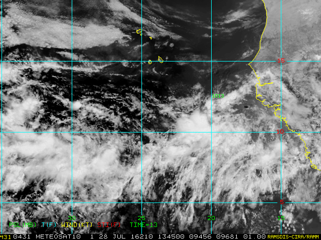
si pasa al sur por la 15 podria afectar fuerte menta ala isla
Re: Invest 97l con 20%/30%
modelo nam en sus nueva corrida


Re: Invest 97l con 20%/30%
Lo sierto es que podriamos estar sintiendo vientos en rafagas para el domingo y el lunes tanto para Puerto Rico como para Republica Dominicana


Re: Invest 97l con 20%/30%
viento de tormenta sobre rep dom

Re: Invest 97l con 20%/30%
Miren qué lindos... 96L y 97L

Siempre la Madre Naturaleza es la última que ríe.
-
StormWatch
- Cat. 3

- Posts: 3721
- Joined: Thu Aug 06, 2015 11:39 am
- Location: Texas, USA
Re: Invest 97l con 20%/30%
Vigilante wrote:Miren qué lindos... 96L y 97L
Tenga su LIKE!
Member Since 2005
For official information, please refer to NHC: https://www.nhc.noaa.gov
Hurricane’s hit Puerto Rico:
San Felipe 1928, San Ciprián 1932, Santa Clara 1956, Hugo 1989, Marilyn 1995, Hortense 1996, Georges 1998, Maria 2017, Fiona 2022
Model Runs:
GFS:
[5:30 AM/PM, 11:30 AM/PM]
HWRF, GFDL, UKMET, NAVGEM:
[6:30-8:00 AM/PM, 12:30-2:00 AM/PM]
ECMWF:
[1:45 AM/PM]
Re: Invest 97l con 20%/30%
Lo que no me gusta del 96L es que se dirige directo a la densa caba de SAL...

Queeeee haaaaaaaceeeeeeesssss!!!!


Queeeee haaaaaaaceeeeeeesssss!!!!
-
StormWatch
- Cat. 3
- Posts: 3721
- Joined: Thu Aug 06, 2015 11:39 am
- Location: Texas, USA
Re: Invest 97l con 20%/30%
Yeappppppppppp tremenda pelota de SAL, ya antes lo había comentado.Arlequín wrote:Lo que no me gusta del 96L es que se dirige directo a la densa caba de SAL...
Queeeee haaaaaaaceeeeeeesssss!!!!
Si se forma.........
Member Since 2005
For official information, please refer to NHC: https://www.nhc.noaa.gov
Hurricane’s hit Puerto Rico:
San Felipe 1928, San Ciprián 1932, Santa Clara 1956, Hugo 1989, Marilyn 1995, Hortense 1996, Georges 1998, Maria 2017, Fiona 2022
Model Runs:
GFS:
[5:30 AM/PM, 11:30 AM/PM]
HWRF, GFDL, UKMET, NAVGEM:
[6:30-8:00 AM/PM, 12:30-2:00 AM/PM]
ECMWF:
[1:45 AM/PM]
For official information, please refer to NHC: https://www.nhc.noaa.gov
Hurricane’s hit Puerto Rico:
San Felipe 1928, San Ciprián 1932, Santa Clara 1956, Hugo 1989, Marilyn 1995, Hortense 1996, Georges 1998, Maria 2017, Fiona 2022
Model Runs:
GFS:
[5:30 AM/PM, 11:30 AM/PM]
HWRF, GFDL, UKMET, NAVGEM:
[6:30-8:00 AM/PM, 12:30-2:00 AM/PM]
ECMWF:
[1:45 AM/PM]

Re: Invest 97l con 20%/30%
TROPICAL WEATHER OUTLOOK
NWS NATIONAL HURRICANE CENTER MIAMI FL
800 PM EDT THU JUL 28 2016
For the North Atlantic...Caribbean Sea and the Gulf of Mexico:
A tropical wave located over the Atlantic halfway between the west
coast of Africa and the Lesser Antilles is moving rapidly westward.
Given the fast motion of the system, development, if any, will be
slow to occur. However, this system will likely bring showers and
gusty winds to portions of the Leeward Islands during the weekend,
and then, the activity should spread westward across the Caribbean
Sea.
* Formation chance through 48 hours...low...20 percent
* Formation chance through 5 days...low...30 percent
$$
Forecaster Avila
emh- huracan es simplemente ahora Edgardo. Importante: Phil Klotzbach, recordó que "el mejor momento para prepararse para los huracanes es cuando todavía no hay huracanes".
-
StormWatch
- Cat. 3
- Posts: 3721
- Joined: Thu Aug 06, 2015 11:39 am
- Location: Texas, USA
Re: Invest 97l con 20%/30%
TROPICAL WEATHER OUTLOOK
NWS NATIONAL HURRICANE CENTER MIAMI FL
800 PM EDT THU JUL 28 2016
48 hours...low...20 percent
5 days...low...30 percent

NWS NATIONAL HURRICANE CENTER MIAMI FL
800 PM EDT THU JUL 28 2016
48 hours...low...20 percent
5 days...low...30 percent
Member Since 2005
For official information, please refer to NHC: https://www.nhc.noaa.gov
Hurricane’s hit Puerto Rico:
San Felipe 1928, San Ciprián 1932, Santa Clara 1956, Hugo 1989, Marilyn 1995, Hortense 1996, Georges 1998, Maria 2017, Fiona 2022
Model Runs:
GFS:
[5:30 AM/PM, 11:30 AM/PM]
HWRF, GFDL, UKMET, NAVGEM:
[6:30-8:00 AM/PM, 12:30-2:00 AM/PM]
ECMWF:
[1:45 AM/PM]
For official information, please refer to NHC: https://www.nhc.noaa.gov
Hurricane’s hit Puerto Rico:
San Felipe 1928, San Ciprián 1932, Santa Clara 1956, Hugo 1989, Marilyn 1995, Hortense 1996, Georges 1998, Maria 2017, Fiona 2022
Model Runs:
GFS:
[5:30 AM/PM, 11:30 AM/PM]
HWRF, GFDL, UKMET, NAVGEM:
[6:30-8:00 AM/PM, 12:30-2:00 AM/PM]
ECMWF:
[1:45 AM/PM]