
Tropical Storm Otto - It's over
-
Georges_98
- Invest

- Posts: 230
- Joined: Fri Sep 02, 2016 2:27 am
Re: Invest 90L, Caribe Occidental, Rojo:Sube 30%-80%
Este eventual sistema puede recordarnos a la tormenta tropical Odette. Un "zurdo" que pasó por RD en el 2003 y dejó un par de víctimas en la isla. Su lugar de origen es prácticamente el mismo que el posible "Otto" y los modelos lo señalan con idénticas trayectorias. RD y PR están en sus posibles destinos y no hay que olvidar al categoría 4 Paloma (Cuba), que aunque no fue totalmente "zurdo", tuvo su punto de origen en este mismo lugar que intenta nacer "Otto". Como dice Rockstorm, luce que necesitaremos más paciencia de la normal con la incertidumbre sobre su trayectoria. Nos esperan unos días de intensos "análisis".
-
ROCKstormSJ4315

- Tormenta Tropical

- Posts: 888
- Joined: Tue Aug 06, 2013 10:09 pm
- Location: Hato Rey, San Juan, PR
Re: Invest 90L, Caribe Occidental, Rojo:Baja 20%-70%
Aun tiene posibilidades, pero ante la menor organizacion en las ultimas horas, le bajan %.
Aqui el ultimo TWO de NHC en Miami:
"TROPICAL WEATHER OUTLOOK
NWS NATIONAL HURRICANE CENTER MIAMI FL
700 AM EST THU NOV 17 2016
For the North Atlantic...Caribbean Sea and the Gulf of Mexico:
1. Cloudiness and showers over the southwestern Caribbean Sea are
associated with a broad low pressure area. This system has become
a little less organized since yesterday. However, environmental
conditions are expected to be conducive for slow development during
the next several days, and a tropical depression could form over the
weekend or early next week while the low moves slowly and
erratically.
* Formation chance through 48 hours...low...20 percent
* Formation chance through 5 days...high...70 percent
Forecaster Beven"
"Georgy Girl", The Seekers
"Back for Good", Take That
"Perfectionist", SAGA
"Graves Into Gardens", Elevation Worship ft. Brandon Lake
"Thunder", Imagine Dragons
"Viva la Vida", Coldplay
"Back for Good", Take That
"Perfectionist", SAGA
"Graves Into Gardens", Elevation Worship ft. Brandon Lake
"Thunder", Imagine Dragons
"Viva la Vida", Coldplay
-
ROCKstormSJ4315
- Tormenta Tropical
- Posts: 888
- Joined: Tue Aug 06, 2013 10:09 pm
- Location: Hato Rey, San Juan, PR
Re: Invest 90L, Caribe Occidental, Rojo:Baja 20%-70%
Tal como se ha comentado, si este sistema se desarrolla, tardara. Esto parece que va para largo.
Aqui el ultimo TWO del NHC en Miami:
"TROPICAL WEATHER OUTLOOK
NWS NATIONAL HURRICANE CENTER MIAMI FL
700 AM EST FRI NOV 18 2016
For the North Atlantic...Caribbean Sea and the Gulf of Mexico:
1. Disorganized cloudiness and showers over the southwestern Caribbean
Sea are associated with a broad low pressure area. Upper-level
winds have become less conducive, and during the next couple of
days any development should be slow to occur. After that time,
environmental conditions are expected to be more conducive for
gradual development, and a tropical depression could form early
next week while the low moves slowly and erratically.
* Formation chance through 48 hours...low...10 percent
* Formation chance through 5 days...medium...60 percent
Forecaster Beve"
"Georgy Girl", The Seekers
"Back for Good", Take That
"Perfectionist", SAGA
"Graves Into Gardens", Elevation Worship ft. Brandon Lake
"Thunder", Imagine Dragons
"Viva la Vida", Coldplay
"Back for Good", Take That
"Perfectionist", SAGA
"Graves Into Gardens", Elevation Worship ft. Brandon Lake
"Thunder", Imagine Dragons
"Viva la Vida", Coldplay

Re: Invest 90L, Caribe Occidental, Rojo:Baja 10%-60%
Que espera, esto va para largo como dicen los amigos forista, ya no hay mucho consenso en nada, en algunas corridas lo modelos desarrollan, en otras no, a veces más débil en otras más fuerte, a veces lo mueven para Nicaragua en otras lo dejan dando vueltas sin un rumbo fijo, paciencia mucha paciencia con esto no hay de otra.
-
ROCKstormSJ4315
- Tormenta Tropical
- Posts: 888
- Joined: Tue Aug 06, 2013 10:09 pm
- Location: Hato Rey, San Juan, PR
Re: Invest 90L, Caribe Occidental, Rojo:Baja 0%-50%
Ahora que la bajaron, es cuando mejor se ha visto desde que existe y segun pasan las horas se ve mejor. Seguira esa tendencia?. 
Este sistema, como dije antes parece que sera peor que Gaston, en terminos de entenderlo.
Aqui el ultimo TWO del NHC en Miami:
"TROPICAL WEATHER OUTLOOK
NWS NATIONAL HURRICANE CENTER MIAMI FL
100 AM EST SAT NOV 19 2016
For the North Atlantic...Caribbean Sea and the Gulf of Mexico:
1. Showers and thunderstorms have increased somewhat in association
with a broad area of low pressure over the southwestern Caribbean
Sea this evening. However the shower and thunderstorm activity is
disorganized, and surface pressures are not falling. Upper-level
winds are expected to be only marginally conducive for development
over the next couple of days. After that time, environmental
conditions are expected to be more conducive for gradual
development, and a tropical depression could still form early next
week while the low moves slowly and erratically.
* Formation chance through 48 hours...low...near 0 percent
* Formation chance through 5 days...medium...50 percent
Forecaster Pasch"
"Georgy Girl", The Seekers
"Back for Good", Take That
"Perfectionist", SAGA
"Graves Into Gardens", Elevation Worship ft. Brandon Lake
"Thunder", Imagine Dragons
"Viva la Vida", Coldplay
"Back for Good", Take That
"Perfectionist", SAGA
"Graves Into Gardens", Elevation Worship ft. Brandon Lake
"Thunder", Imagine Dragons
"Viva la Vida", Coldplay
-
StormWatch
- Cat. 3

- Posts: 3755
- Joined: Thu Aug 06, 2015 11:39 am
- Location: Texas, USA
Re: Invest 90L, Caribe Occidental, Anaranjado:Baja 0%-50%
Que clase palo dio este Invest 90L
ahora tiene 40-60
SPECIAL TROPICAL WEATHER OUTLOOK
NWS NATIONAL HURRICANE CENTER MIAMI FL
915 AM EST SAT NOV 19 2016
For the North Atlantic...Caribbean Sea and the Gulf of Mexico:
Showers and thunderstorms have increased and become better organized
this morning in association with an area of low pressure located
over the southwestern Caribbean Sea. In addition, satellite data
and surface observations indicate that the circulation has become a
little better defined. Although environmental conditions are only
marginally conducive for additional development, only a small
increase in the organization of the low could result in the
formation of a tropical depression. This system is expected to move
slowly and erratically during the next few days.
* Formation chance through 48 hours...medium...40 percent
* Formation chance through 5 days...medium...60 percent
Member Since 2005
For official information, please refer to NHC: https://www.nhc.noaa.gov
Hurricane’s hit Puerto Rico:
San Felipe 1928, San Ciprián 1932, Santa Clara 1956, Hugo 1989, Marilyn 1995, Hortense 1996, Georges 1998, Maria 2017, Fiona 2022
Model Runs:
GFS:
[5:30 AM/PM, 11:30 AM/PM]
HWRF, GFDL, UKMET, NAVGEM:
[6:30-8:00 AM/PM, 12:30-2:00 AM/PM]
ECMWF:
[1:45 AM/PM]
-
StormWatch
- Cat. 3
- Posts: 3755
- Joined: Thu Aug 06, 2015 11:39 am
- Location: Texas, USA
Re: Invest 90L, Caribe Occidental, Anaranjado:Baja 0%-50%
Esto NOOOO viene para ACA! Tranquilos
Feliz NAVIDAD!
Go CUBS Go
Feliz NAVIDAD!
Go CUBS Go
Member Since 2005
For official information, please refer to NHC: https://www.nhc.noaa.gov
Hurricane’s hit Puerto Rico:
San Felipe 1928, San Ciprián 1932, Santa Clara 1956, Hugo 1989, Marilyn 1995, Hortense 1996, Georges 1998, Maria 2017, Fiona 2022
Model Runs:
GFS:
[5:30 AM/PM, 11:30 AM/PM]
HWRF, GFDL, UKMET, NAVGEM:
[6:30-8:00 AM/PM, 12:30-2:00 AM/PM]
ECMWF:
[1:45 AM/PM]
For official information, please refer to NHC: https://www.nhc.noaa.gov
Hurricane’s hit Puerto Rico:
San Felipe 1928, San Ciprián 1932, Santa Clara 1956, Hugo 1989, Marilyn 1995, Hortense 1996, Georges 1998, Maria 2017, Fiona 2022
Model Runs:
GFS:
[5:30 AM/PM, 11:30 AM/PM]
HWRF, GFDL, UKMET, NAVGEM:
[6:30-8:00 AM/PM, 12:30-2:00 AM/PM]
ECMWF:
[1:45 AM/PM]
-
ROCKstormSJ4315
- Tormenta Tropical
- Posts: 888
- Joined: Tue Aug 06, 2013 10:09 pm
- Location: Hato Rey, San Juan, PR
Re: Invest 90L, Caribe Occidental, Anaranjado:Sube 40%-60%
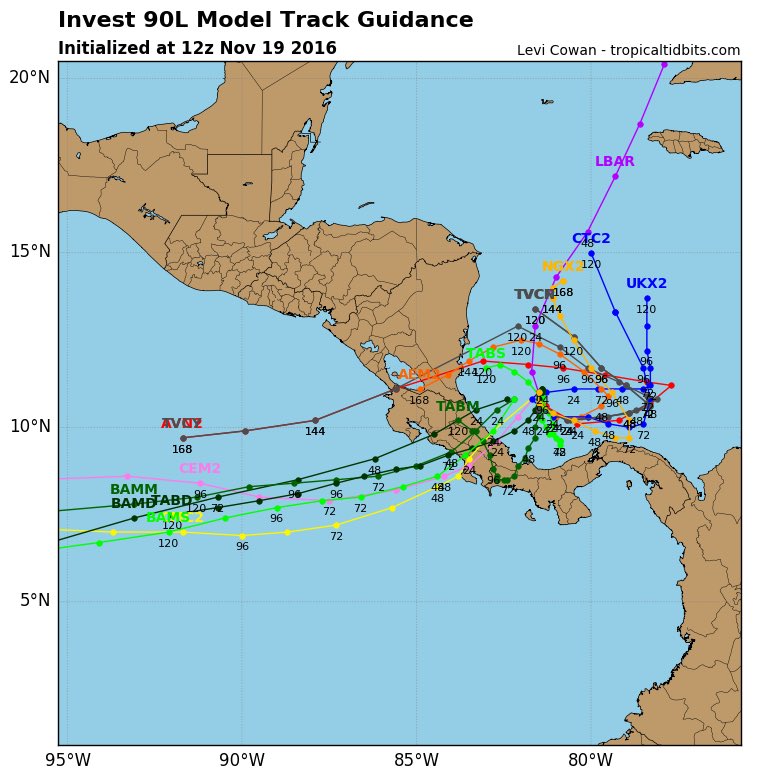
Bueno, ya lo habia comentado de madrugada, que esto se veia mejor y parece que por fin lo vieron.
Hacia donde va, quien sabe.
Cuando se forme el LLC y se mueva sin movimiento erratico, pensare en la trayectoria. Por ahora pareciera que el NHC muestra la formacion del Low un tanto al NE de donde esta ahora, si uno se deja llevar por la forma del area anaranjada. Y sigue aun su movimiento erratico.
Hacia donde va, quien sabe.
Cuando se forme el LLC y se mueva sin movimiento erratico, pensare en la trayectoria.
"Georgy Girl", The Seekers
"Back for Good", Take That
"Perfectionist", SAGA
"Graves Into Gardens", Elevation Worship ft. Brandon Lake
"Thunder", Imagine Dragons
"Viva la Vida", Coldplay
"Back for Good", Take That
"Perfectionist", SAGA
"Graves Into Gardens", Elevation Worship ft. Brandon Lake
"Thunder", Imagine Dragons
"Viva la Vida", Coldplay
-
ROCKstormSJ4315
- Tormenta Tropical
- Posts: 888
- Joined: Tue Aug 06, 2013 10:09 pm
- Location: Hato Rey, San Juan, PR
Re: Invest 90L, Caribe Occidental, Rojo:Sube 50%-70%
Bueno, si sigue la tendencia, podriamos tener una nueva depresion pronto.
Aqui el ultimo informe del NHC en Miami:
"TROPICAL WEATHER OUTLOOK
NWS NATIONAL HURRICANE CENTER MIAMI FL
100 PM EST SAT NOV 19 2016
For the North Atlantic...Caribbean Sea and the Gulf of Mexico:
1. A concentrated area of showers and thunderstorms have been
persisting near the center of an area of low pressure located
over the southwestern Caribbean Sea. In addition, satellite data
suggest that the circulation of the low continues to become better
defined. Although environmental conditions are only marginally
conducive for additional development, only a small increase in the
organization of the low could result in the formation of a tropical
depression. This low is expected to move slowly and erratically
during the next few days.
* Formation chance through 48 hours...medium...50 percent
* Formation chance through 5 days...high...70 percent
Forecaster Cangialosi"
"Georgy Girl", The Seekers
"Back for Good", Take That
"Perfectionist", SAGA
"Graves Into Gardens", Elevation Worship ft. Brandon Lake
"Thunder", Imagine Dragons
"Viva la Vida", Coldplay
"Back for Good", Take That
"Perfectionist", SAGA
"Graves Into Gardens", Elevation Worship ft. Brandon Lake
"Thunder", Imagine Dragons
"Viva la Vida", Coldplay
Re: Invest 90L, Caribe Occidental, Rojo:Sube 50%-70%
Se ve bien a esta hora. veremos.
