
Mira que bien!
Entretenimiento antes q termine la temporada de huracanes!
Falta el out #27, parte baja de la 9na entrada!.....Jajjajajajajajajaaja
Tropical Storm Otto - It's over
-
StormWatch
- Cat. 3

- Posts: 3721
- Joined: Thu Aug 06, 2015 11:39 am
- Location: Texas, USA
Re: Area de Interes, Caribe Occidental, Anaranjado 0%-60%
Member Since 2005
For official information, please refer to NHC: https://www.nhc.noaa.gov
Hurricane’s hit Puerto Rico:
San Felipe 1928, San Ciprián 1932, Santa Clara 1956, Hugo 1989, Marilyn 1995, Hortense 1996, Georges 1998, Maria 2017, Fiona 2022
Model Runs:
GFS:
[5:30 AM/PM, 11:30 AM/PM]
HWRF, GFDL, UKMET, NAVGEM:
[6:30-8:00 AM/PM, 12:30-2:00 AM/PM]
ECMWF:
[1:45 AM/PM]
-
ROCKstormSJ4315

- Tormenta Tropical

- Posts: 888
- Joined: Tue Aug 06, 2013 10:09 pm
- Location: Hato Rey, San Juan, PR
Re: Area de Interes, Caribe Occidental, Rojo 10%-70%
Bueno, segun esperado, suben los porcientos
Solo falta ver que se desarolle completamente el sistema y monitorear el movimiento que para estas fechas sera muy dificil, pero que tiene buena posibilidad de ser un "Reverse Storm".
Aqui esta el ultimo TWO del NHC en Miami:
"TROPICAL WEATHER OUTLOOK
NWS NATIONAL HURRICANE CENTER MIAMI FL
700 PM EST MON NOV 14 2016
For the North Atlantic...Caribbean Sea and the Gulf of Mexico:
1. Cloudiness and thunderstorms have increased over the southwestern
Caribbean Sea in association with a broad area of low pressure that
is gradually forming across the region. Environmental conditions
are conducive for slow development of this disturbance during the
next several days, and a tropical depression is likely to form by
late this week or over the weekend while the low drifts northward or
northeastward.
* Formation chance through 48 hours...low...10 percent
* Formation chance through 5 days...high...70 percent
Forecaster Kimberlain"
"Georgy Girl", The Seekers
"Back for Good", Take That
"Perfectionist", SAGA
"Graves Into Gardens", Elevation Worship ft. Brandon Lake
"Thunder", Imagine Dragons
"Viva la Vida", Coldplay
"Back for Good", Take That
"Perfectionist", SAGA
"Graves Into Gardens", Elevation Worship ft. Brandon Lake
"Thunder", Imagine Dragons
"Viva la Vida", Coldplay

Re: Area de Interes, Caribe Occidental, Rojo 10%-70%
Saludos
Aqui parece que el # 15 de la temporada tiene el consenso de los modelos para el bautismo de Otto, sin embargo la ruta sera un dolor de cabeza, asi que a observar por muchos dias.
Aqui parece que el # 15 de la temporada tiene el consenso de los modelos para el bautismo de Otto, sin embargo la ruta sera un dolor de cabeza, asi que a observar por muchos dias.
-
ROCKstormSJ4315
- Tormenta Tropical
- Posts: 888
- Joined: Tue Aug 06, 2013 10:09 pm
- Location: Hato Rey, San Juan, PR
Re: Area de Interes, Caribe Occidental, Rojo:Sube 10%-80%
Sube 10% mas a largo plazo.
Aqui el ultimo TWO del NHC en Miami:
"TROPICAL WEATHER OUTLOOK
NWS NATIONAL HURRICANE CENTER MIAMI FL
700 AM EST TUE NOV 15 2016
For the North Atlantic...Caribbean Sea and the Gulf of Mexico:
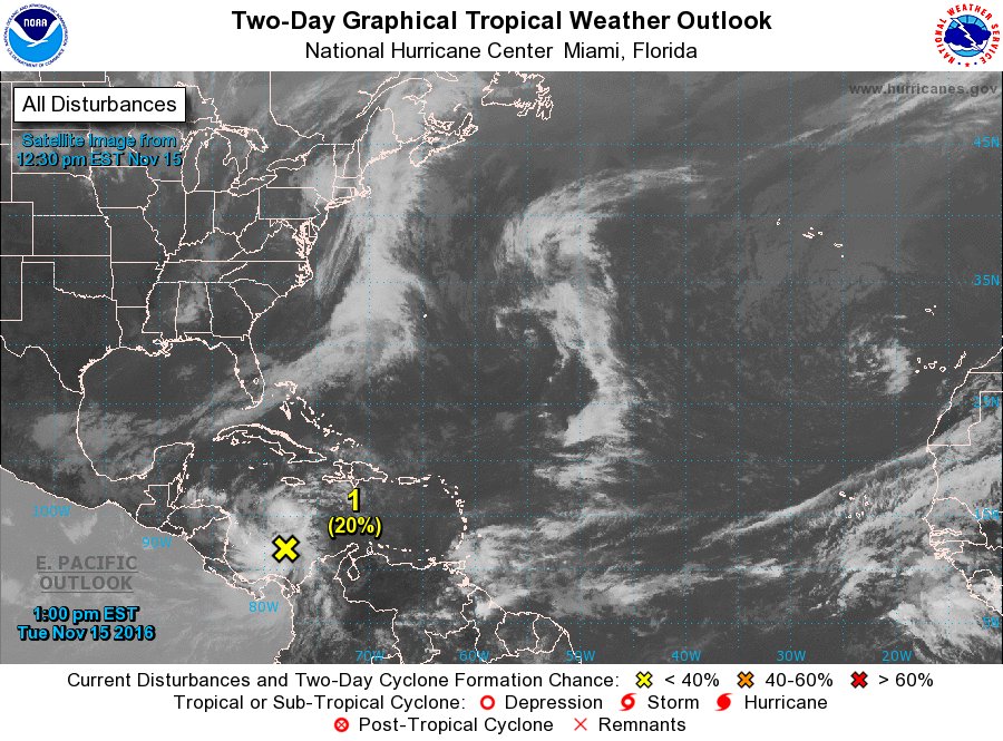
1. A large area cloudiness and thunderstorms is associated with a
broad low pressure system located over the southwestern Caribbean
Sea. Environmental conditions are expected to be conducive for slow
development of this disturbance during the next several days, and a
tropical depression is likely to form by late this week or over the
weekend while the low drifts northward or northeastward.
* Formation chance through 48 hours...low...10 percent
* Formation chance through 5 days...high...80 percent
Forecaster Stewart"
Aqui el ultimo TWO del NHC en Miami:
"TROPICAL WEATHER OUTLOOK
NWS NATIONAL HURRICANE CENTER MIAMI FL
700 AM EST TUE NOV 15 2016
For the North Atlantic...Caribbean Sea and the Gulf of Mexico:
1. A large area cloudiness and thunderstorms is associated with a
broad low pressure system located over the southwestern Caribbean
Sea. Environmental conditions are expected to be conducive for slow
development of this disturbance during the next several days, and a
tropical depression is likely to form by late this week or over the
weekend while the low drifts northward or northeastward.
* Formation chance through 48 hours...low...10 percent
* Formation chance through 5 days...high...80 percent
Forecaster Stewart"
"Georgy Girl", The Seekers
"Back for Good", Take That
"Perfectionist", SAGA
"Graves Into Gardens", Elevation Worship ft. Brandon Lake
"Thunder", Imagine Dragons
"Viva la Vida", Coldplay
"Back for Good", Take That
"Perfectionist", SAGA
"Graves Into Gardens", Elevation Worship ft. Brandon Lake
"Thunder", Imagine Dragons
"Viva la Vida", Coldplay
-
ROCKstormSJ4315
- Tormenta Tropical
- Posts: 888
- Joined: Tue Aug 06, 2013 10:09 pm
- Location: Hato Rey, San Juan, PR
Re: Invest 90L, Caribe Occidental, Rojo:Sube 10%-80%
Bueno, en algunas paginas ya le llaman Invest 90L. No obstante cuando uno va la pagina de los "Floaters" le llaman Genesis036 
"Georgy Girl", The Seekers
"Back for Good", Take That
"Perfectionist", SAGA
"Graves Into Gardens", Elevation Worship ft. Brandon Lake
"Thunder", Imagine Dragons
"Viva la Vida", Coldplay
"Back for Good", Take That
"Perfectionist", SAGA
"Graves Into Gardens", Elevation Worship ft. Brandon Lake
"Thunder", Imagine Dragons
"Viva la Vida", Coldplay
-
StormWatch
- Cat. 3
- Posts: 3721
- Joined: Thu Aug 06, 2015 11:39 am
- Location: Texas, USA
Re: Invest 90L, Caribe Occidental, Rojo:Sube 10%-80%
Invest 90L

Member Since 2005
For official information, please refer to NHC: https://www.nhc.noaa.gov
Hurricane’s hit Puerto Rico:
San Felipe 1928, San Ciprián 1932, Santa Clara 1956, Hugo 1989, Marilyn 1995, Hortense 1996, Georges 1998, Maria 2017, Fiona 2022
Model Runs:
GFS:
[5:30 AM/PM, 11:30 AM/PM]
HWRF, GFDL, UKMET, NAVGEM:
[6:30-8:00 AM/PM, 12:30-2:00 AM/PM]
ECMWF:
[1:45 AM/PM]
For official information, please refer to NHC: https://www.nhc.noaa.gov
Hurricane’s hit Puerto Rico:
San Felipe 1928, San Ciprián 1932, Santa Clara 1956, Hugo 1989, Marilyn 1995, Hortense 1996, Georges 1998, Maria 2017, Fiona 2022
Model Runs:
GFS:
[5:30 AM/PM, 11:30 AM/PM]
HWRF, GFDL, UKMET, NAVGEM:
[6:30-8:00 AM/PM, 12:30-2:00 AM/PM]
ECMWF:
[1:45 AM/PM]
-
StormWatch
- Cat. 3
- Posts: 3721
- Joined: Thu Aug 06, 2015 11:39 am
- Location: Texas, USA
Re: Invest 90L, Caribe Occidental, Rojo:Sube 10%-80%
Para donde va?
Member Since 2005
For official information, please refer to NHC: https://www.nhc.noaa.gov
Hurricane’s hit Puerto Rico:
San Felipe 1928, San Ciprián 1932, Santa Clara 1956, Hugo 1989, Marilyn 1995, Hortense 1996, Georges 1998, Maria 2017, Fiona 2022
Model Runs:
GFS:
[5:30 AM/PM, 11:30 AM/PM]
HWRF, GFDL, UKMET, NAVGEM:
[6:30-8:00 AM/PM, 12:30-2:00 AM/PM]
ECMWF:
[1:45 AM/PM]
For official information, please refer to NHC: https://www.nhc.noaa.gov
Hurricane’s hit Puerto Rico:
San Felipe 1928, San Ciprián 1932, Santa Clara 1956, Hugo 1989, Marilyn 1995, Hortense 1996, Georges 1998, Maria 2017, Fiona 2022
Model Runs:
GFS:
[5:30 AM/PM, 11:30 AM/PM]
HWRF, GFDL, UKMET, NAVGEM:
[6:30-8:00 AM/PM, 12:30-2:00 AM/PM]
ECMWF:
[1:45 AM/PM]
-
StormWatch
- Cat. 3
- Posts: 3721
- Joined: Thu Aug 06, 2015 11:39 am
- Location: Texas, USA
Re: Invest 90L, Caribe Occidental, Rojo:Sube 10%-80%
100 PM EST TUE NOV 15 2016
Formation chance through 48 hours...low...20 percent
Formation chance through 5 days...high...80 percent
Formation chance through 48 hours...low...20 percent
Formation chance through 5 days...high...80 percent
Member Since 2005
For official information, please refer to NHC: https://www.nhc.noaa.gov
Hurricane’s hit Puerto Rico:
San Felipe 1928, San Ciprián 1932, Santa Clara 1956, Hugo 1989, Marilyn 1995, Hortense 1996, Georges 1998, Maria 2017, Fiona 2022
Model Runs:
GFS:
[5:30 AM/PM, 11:30 AM/PM]
HWRF, GFDL, UKMET, NAVGEM:
[6:30-8:00 AM/PM, 12:30-2:00 AM/PM]
ECMWF:
[1:45 AM/PM]
For official information, please refer to NHC: https://www.nhc.noaa.gov
Hurricane’s hit Puerto Rico:
San Felipe 1928, San Ciprián 1932, Santa Clara 1956, Hugo 1989, Marilyn 1995, Hortense 1996, Georges 1998, Maria 2017, Fiona 2022
Model Runs:
GFS:
[5:30 AM/PM, 11:30 AM/PM]
HWRF, GFDL, UKMET, NAVGEM:
[6:30-8:00 AM/PM, 12:30-2:00 AM/PM]
ECMWF:
[1:45 AM/PM]
-
ROCKstormSJ4315
- Tormenta Tropical
- Posts: 888
- Joined: Tue Aug 06, 2013 10:09 pm
- Location: Hato Rey, San Juan, PR
Re: Invest 90L, Caribe Occidental, Rojo:Sube 20%-80%
Ultimo TWO del sistema, segun el NHC en Miami:
"TROPICAL WEATHER OUTLOOK
NWS NATIONAL HURRICANE CENTER MIAMI FL
100 PM EST TUE NOV 15 2016
For the North Atlantic...Caribbean Sea and the Gulf of Mexico:
1. A large area cloudiness and thunderstorms is associated with a
broad low pressure system located over the southwestern Caribbean
Sea. Environmental conditions are expected to be conducive for slow
development of this disturbance during the next several days, and a
tropical depression is likely to form by late this week or over the
weekend while the low drifts generally northward.
* Formation chance through 48 hours...low...20 percent
* Formation chance through 5 days...high...80 percent
Forecaster Stewart""
"Georgy Girl", The Seekers
"Back for Good", Take That
"Perfectionist", SAGA
"Graves Into Gardens", Elevation Worship ft. Brandon Lake
"Thunder", Imagine Dragons
"Viva la Vida", Coldplay
"Back for Good", Take That
"Perfectionist", SAGA
"Graves Into Gardens", Elevation Worship ft. Brandon Lake
"Thunder", Imagine Dragons
"Viva la Vida", Coldplay
-
ROCKstormSJ4315
- Tormenta Tropical
- Posts: 888
- Joined: Tue Aug 06, 2013 10:09 pm
- Location: Hato Rey, San Juan, PR
Re: Invest 90L, Caribe Occidental, Rojo:Sube 20%-80%
Creo que este sistema le ganara al famoso Gaston. Digno de gastarle o quemarle a uno las dendritas del cerebro.
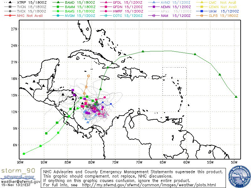
En primer lugar, aun no hay circulacion cerrada. Por tanto, ya es sabido que para mi, los modelos de trayectoria, sin centro de circulacion no me dicen nada. Aun mirando los palitos chinos o mikados(modelos de trayectoria) parecen una de esas maquinas de Chiclets o sopresas de 25 centavos, que uno cuando niño seguia colocandole monedas a ver si salia lo que uno queria y nunca salia lo que uno queria. Es decir, aun los modelos parecen palitos chinos en microondas. En otras palabras no dicen nada de la trayectoria. Sumale que para estas fechas las trayectorias de estos sistemas son muy dificiles de predecir. Aunque esa X la veo mas al este segun cambian los TWO. Eso me hace pensar que hay buena posiblidad que se mueva mas al este-noreste que al norte. Un posible "Reverse Storm".
A eso se le suma, que se estima que estara unos cuandos dias casi estacionaria o "meandering", lo que hara que cada dia la posible trayectoria dependa de cualquier cosa a su alrededor. Por tanto, en ese tiempo podria ganar mucha fuerza como tambien debilitarse, moverse sobre PR o ni siquiera acercarse. Lo mas que queda es monitorear lo que pasa en los proximos dias.
Aqui el ultimo TWO del NHC en Miami:
"TROPICAL WEATHER OUTLOOK
NWS NATIONAL HURRICANE CENTER MIAMI FL
100 AM EST WED NOV 16 2016
For the North Atlantic...Caribbean Sea and the Gulf of Mexico:
1. A large area of cloudiness and showers over the southwestern
Caribbean Sea are associated with a broad low pressure system.
Environmental conditions are expected to be conducive for slow
development of this system during the next several days, and a
tropical depression is likely to form late this week or over the
weekend while the low moves little.
* Formation chance through 48 hours...low...30 percent
* Formation chance through 5 days...high...80 percent
Forecaster Cangialosi"
"Georgy Girl", The Seekers
"Back for Good", Take That
"Perfectionist", SAGA
"Graves Into Gardens", Elevation Worship ft. Brandon Lake
"Thunder", Imagine Dragons
"Viva la Vida", Coldplay
"Back for Good", Take That
"Perfectionist", SAGA
"Graves Into Gardens", Elevation Worship ft. Brandon Lake
"Thunder", Imagine Dragons
"Viva la Vida", Coldplay