Aquí encontrarás todo lo relacionado al la meteorología en Puerto Rico y las condiciones del tiempo actuales, así como los huracanes que se desarrollen durante las temporadas ciclónicas, actualizados por expertos y aficionados a la meteorología de todo el pais! Este es tu foro! Leelo, escribe en el y disfrútalo! Cycloman.
Hurricane’s hit Puerto Rico: San Felipe 1928, San Ciprián 1932, Santa Clara 1956, Hugo 1989, Marilyn 1995, Hortense 1996, Georges 1998, Maria 2017, Fiona 2022
Curiosamente el americano esta rogando pq este Invest se desarrolle, puede debilitar la alta presion y alejar al temible de Matthew de la costa este de los Estados Unidos.
BULLETIN
TROPICAL STORM NICOLE ADVISORY NUMBER 1
NWS NATIONAL HURRICANE CENTER MIAMI FL AL152016
1100 AM AST TUE OCT 04 2016
...NEW TROPICAL STORM IN THE ATLANTIC...
SUMMARY OF 1100 AM AST...1500 UTC...INFORMATION
-----------------------------------------------
LOCATION...23.8N 60.4W
ABOUT 525 MI...840 KM NE OF SAN JUAN PUERTO RICO
MAXIMUM SUSTAINED WINDS...50 MPH...85 KM/H
PRESENT MOVEMENT...NW OR 310 DEGREES AT 8 MPH...13 KM/H
MINIMUM CENTRAL PRESSURE...1005 MB...29.68 INCHES
WATCHES AND WARNINGS
--------------------
There are no coastal watches or warnings in effect.
DISCUSSION AND 48-HOUR OUTLOOK
------------------------------
At 1100 AM AST (1500 UTC), the center of Tropical Storm Nicole was
located near latitude 23.8 North, longitude 60.4 West. Nicole is
moving toward the northwest near 8 mph (13 km/h) and a turn toward
the north-northwest with a decrease in forward speed is expected
over the next couple of days.
Maximum sustained winds are near 50 mph (85 km/h) with higher gusts.
Little change in strength is forecast for the next day or so,
followed by gradual weakening.
Tropical-storm-force winds extend outward up to 70 miles (110 km)
from the center.
The estimated minimum central pressure is 1005 mb (29.68 inches).
HAZARDS AFFECTING LAND
----------------------
None.
NEXT ADVISORY
-------------
Next complete advisory at 500 PM AST.
Hurricane’s hit Puerto Rico: San Felipe 1928, San Ciprián 1932, Santa Clara 1956, Hugo 1989, Marilyn 1995, Hortense 1996, Georges 1998, Maria 2017, Fiona 2022
Hurricane’s hit Puerto Rico: San Felipe 1928, San Ciprián 1932, Santa Clara 1956, Hugo 1989, Marilyn 1995, Hortense 1996, Georges 1998, Maria 2017, Fiona 2022
Hurricane’s hit Puerto Rico: San Felipe 1928, San Ciprián 1932, Santa Clara 1956, Hugo 1989, Marilyn 1995, Hortense 1996, Georges 1998, Maria 2017, Fiona 2022
De esta, no comente nada, pero siempre supe que se iba a desarrollar en un ciclon.
Bueno...no siempre.
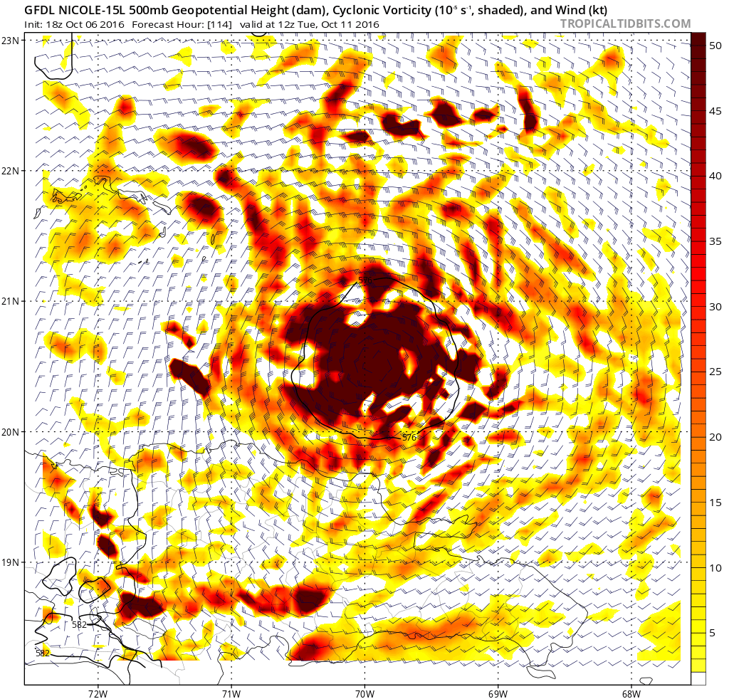
Si, desde el momento que empezo a aumentar la vorticidad cientos de millas al este de Barlovento mientra se desplazaba hacia el oeste y luego se mantuvo majomenos estacionaria por algun tiempo.
Un momento!__Buscamos la razon de este frenazo...una vaguada lo comenzo a halar hacia el norte...para el Caribe, ni de turista!
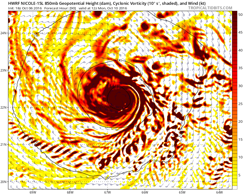
De ahi en mas era simple el pronostico, aplicamos la consabida formula: "trayectoria sin sistema...sistema sin trayectoria" Si se va es que habra ciclon...no hay de otra!__Efectivamente...ahi tenemos a Nicole, una tormenta que, de momento es una de las mas feas de la temporada, no me apena decirlo y a quien le deseamos la mejor de las suertes.
BULLETIN
HURRICANE NICOLE SPECIAL ADVISORY NUMBER 10
NWS NATIONAL HURRICANE CENTER MIAMI FL AL152016
200 PM AST THU OCT 06 2016
...NICOLE BECOMES A HURRICANE...
SUMMARY OF 200 PM AST...1800 UTC...INFORMATION
----------------------------------------------
LOCATION...27.3N 65.0W
ABOUT 345 MI...555 KM S OF BERMUDA
ABOUT 620 MI...995 KM N OF SAN JUAN PUERTO RICO
MAXIMUM SUSTAINED WINDS...80 MPH...130 KM/H
PRESENT MOVEMENT...NW OR 325 DEGREES AT 8 MPH...13 KM/H
MINIMUM CENTRAL PRESSURE...985 MB...29.09 INCHES
WATCHES AND WARNINGS
--------------------
There are no coastal watches or warnings in effect.
DISCUSSION AND 48-HOUR OUTLOOK
------------------------------
At 200 PM AST (1800 UTC), the center of Hurricane Nicole was located
near latitude 27.2 North, longitude 64.9 West. Nicole is moving
toward the north-northwest near 7 mph (11 km/h). A turn toward the
north-northwest is expected later today. A slow and meandering
motion is forecast tonight and Friday.
Maximum sustained winds have increased to near 80 mph (130 km/h)
with higher gusts. Some additional strengthening is likely over
the nest day or so, followed by slow weakening.
Hurricane-force winds extend outward up to 15 miles (30 km) from the
center and tropical-storm-force winds extend outward up to 70 miles
(110 km).
The estimated minimum central pressure is 985 mb (29.09 inches).
HAZARDS AFFECTING LAND
----------------------
SURF: Swells associated with Nicole, along with rough surf
conditions, will affect Bermuda for the next few days.
NEXT ADVISORY
-------------
Next complete advisory at 500 PM AST.
$$
Forecaster Pasch
Disclaimer: "Solo soy otro fan de la meteorolgia...para informacion mas precisa vaya a buscarla del NHC y del SNM.... No soy la voz oficial de comunicaciones de la AAA asi que pendiente a sus anuncios oficiales en los medios de comunicación de prensa escrita, radial, televisiva, redes socials, etc."