Page 3 of 4
Re: Onda Tropical Atlántic AL92 80-90%
Posted: Sun Jun 18, 2023 10:41 pm
by E. Irizarry
TTAA00 KNHC DDHHMM
Tropical Weather Outlook
NWS National Hurricane Center Miami FL
800 PM EDT Sun Jun 18 2023
For the North Atlantic...Caribbean Sea and the Gulf of Mexico:
1. Central Tropical Atlantic (AL92):
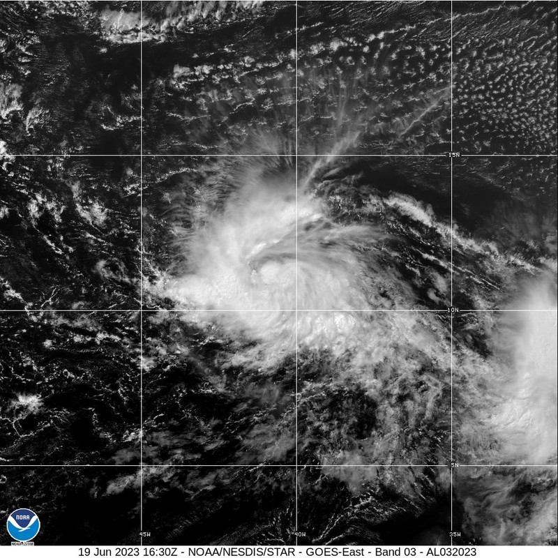
Showers and thunderstorms continue to become better organized in
association with a broad area of low pressure located several
hundred miles southwest of the Cabo Verde Islands. Environmental
conditions appear conducive for additional development, and a
tropical depression or tropical storm is expected to form over the
next day or so. This system is forecast to move westward at 15 to 20
mph across the central tropical Atlantic with further development
through the middle part of the week. Additional information on this
system, including gale warnings, can be found in High Seas Forecasts
issued by the National Weather Service.
* Formation chance through 48 hours...high...90 percent.
* Formation chance through 7 days...high...90 percent.
Re: Onda Tropical Atlántic AL92 80-90%
Posted: Mon Jun 19, 2023 6:15 am
by Arlequín
Ultima corrida de los modelos
El caribe debe estar atentos a este sistema
Re: Onda Tropical Atlántic AL92 80-90%
Posted: Mon Jun 19, 2023 8:10 am
by Arlequín
Lo que nos salvaría es que se este debilitando al entrar al caribe, en cuanto a la ruta parece que todo se esta alineando para nuestras áreas...atentos a este sistema

Depresión Tropical #3 Atlantico Central
Posted: Mon Jun 19, 2023 10:26 am
by E. Irizarry
Bueno, el caramelo ya está. Tenemos Depresión Tropical
A esperar el boletín completo y posible trayectoria, inicialmente pienso que se irán con un "Happy Medium " entre el Euro y GFS y eso da como resultado en NE del Caribe. A esperar la información completa a las 11am
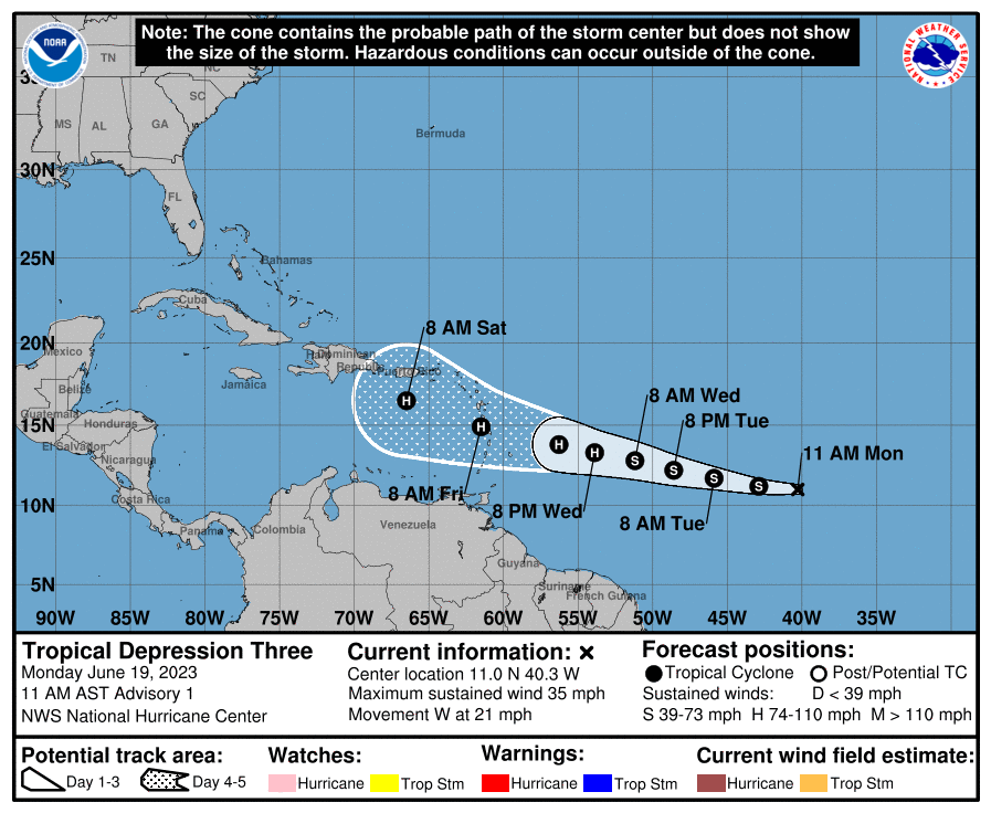
NHC will initiate advisories on Tropical Depression Three, located over the central Tropical Atlantic, at 1100 AM AST (1500 UTC).
Re: Depresión Tropical #3 en el Atlántico central
Posted: Mon Jun 19, 2023 11:48 am
by Obi-Wan
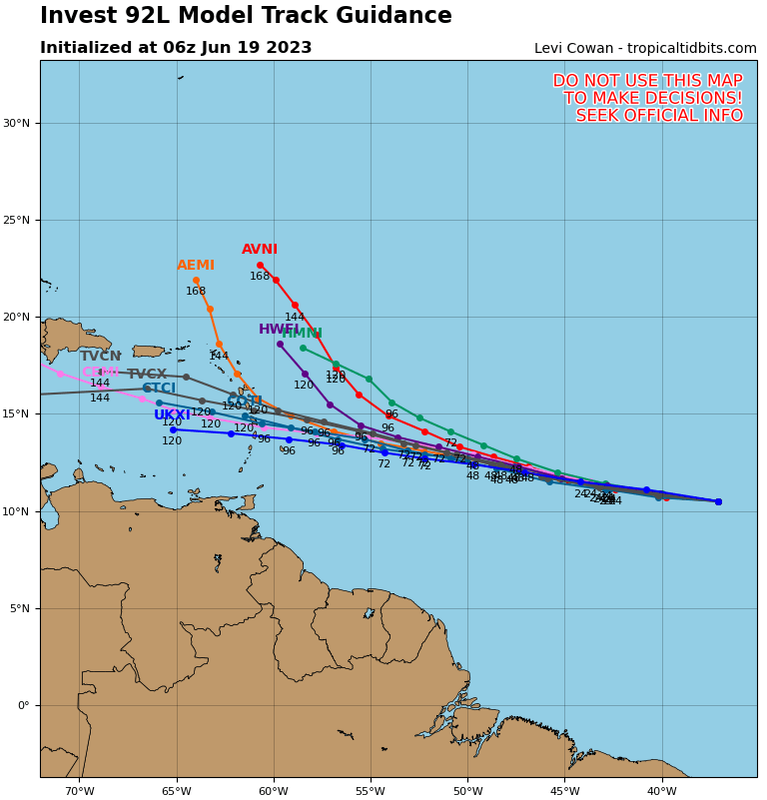
El NHC fue políticamente correcto al realizar una mezcla entre la trayectoria del Euro y la intensidad del GFS.
Asi que entre una tormenta o huracan categoría 1 sobre nuestra zona o muy cerca es posible para el fin de semana.
Pero como dice el mismo pronóstico, aun hay disparidad entre los modelos, tanto en trayectoria como intensidad y por lo tanto el margen de error es alto y habran ajustes.
Seguiremos atentos.
Re: Depresión Tropical #3 en el Atlántico central
Posted: Mon Jun 19, 2023 11:52 am
by Obi-Wan
Para record:
Re: Depresión Tropical #3 en el Atlántico central
Posted: Mon Jun 19, 2023 4:16 pm
by E. Irizarry
Saludos
Creo que "nació " Bret, Todavía no es Oficial, pero los T numbers así la califican.
La tendencia del GFS se terminó de dar y ahora trae al futuro Bret a nuestra área, y también con el patrón de debilitarlo al entrar al Caribe.
La trayectoria tiene una clara tendencia hacia el ENE Del Caribe, lo que es bien incierto es la intensidad. Dependerá del Timming y el rol que jugará la vaguada y donde se posicione.
A esperar el boletín de las 5pm
Re: Depresión Tropical #3 en el Atlántico central
Posted: Mon Jun 19, 2023 4:41 pm
by Obi-Wan
Para record TT Bret:
Re: Depresión Tropical #3 en el Atlántico central
Posted: Mon Jun 19, 2023 4:50 pm
by Arlequín
En mi opinión... tengo mis dudas de que siga como huracán cuando entre al caribe... sobretodo viendo lo que muestran los ensembles del EURO, pero ellos son los que saben en la materia yo solo digo una opinión personal

Mientras tanto el sistema se ve cada vez mejor con el pasar de las horas
Re: Depresión Tropical #3 en el Atlántico central
Posted: Mon Jun 19, 2023 4:52 pm
by E. Irizarry
000
WTNT33 KNHC 192042
TCPAT3
BULLETIN
Tropical Storm Bret Advisory Number 2
NWS National Hurricane Center Miami FL AL032023
500 PM AST Mon Jun 19 2023
...TROPICAL STORM BRET FORMS OVER THE CENTRAL ATLANTIC...
...INTERESTS IN THE LESSER ANTILLES SHOULD MONITOR THIS SYSTEM...
SUMMARY OF 500 PM AST...2100 UTC...INFORMATION
----------------------------------------------
LOCATION...11.3N 42.2W
ABOUT 1295 MI...2085 KM E OF THE SOUTHERN WINDWARD ISLANDS
MAXIMUM SUSTAINED WINDS...40 MPH...65 KM/H
PRESENT MOVEMENT...W OR 280 DEGREES AT 21 MPH...33 KM/H
MINIMUM CENTRAL PRESSURE...1008 MB...29.77 INCHES
WATCHES AND WARNINGS
--------------------
There are no coastal watches or warnings in effect.
Interests in the Lesser Antilles should monitor the progress of
this system.