
Huracan Fiona Cat 1 - Al sur de Puerto Rico
-
Georges_98
- Invest

- Posts: 227
- Joined: Fri Sep 02, 2016 2:27 am
Re: Onda Tropical Atlantico Central 30%/40%
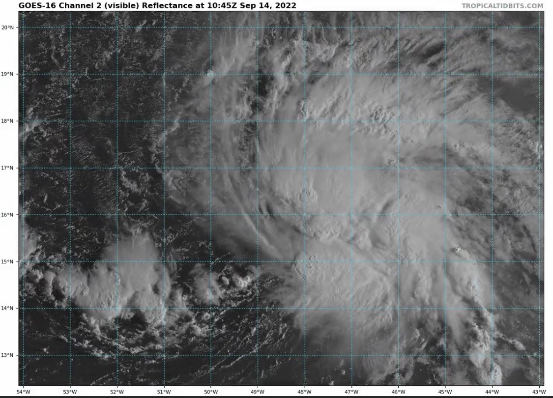
Muy bien establecidas que están las dos Highs. La estarán acompañando hasta las 60w. Hay una gran capa de SAL alrededor de la onda, pero increíblemente está batallando con ella con notable éxito. Si consigue desarrollo y entra a Depresión antes de las 50w podemos respirar tranquilos, ya que la High próxima a las Bermudas comenzará a deblitarse en 72 hrs, lo que le permitiría un giro hacia el norte y pescadolandia con ella.

Re: Onda Tropical Atlantico Central 30%/40%
Que bueno que mencionas el SAL porque justo eso iba a postear... parece ser que ira desvaneciendose esa capa de polvo sahariano segun el pronostico de hoyGeorges_98 wrote: ↑Tue Sep 13, 2022 11:03 am Muy bien establecidas que están las dos Highs. La estarán acompañando hasta las 60w. Hay una gran capa de SAL alrededor de la onda, pero increíblemente está batallando con ella con notable éxito. Si consigue desarrollo y entra a Depresión antes de las 50w podemos respirar tranquilos, ya que la High próxima a las Bermudas comenzará a deblitarse en 72 hrs, lo que le permitiría un giro hacia el norte y pescadolandia con ella.
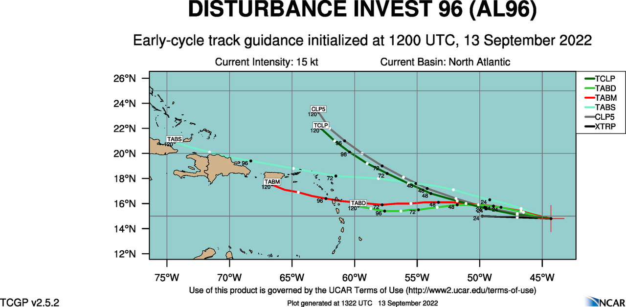
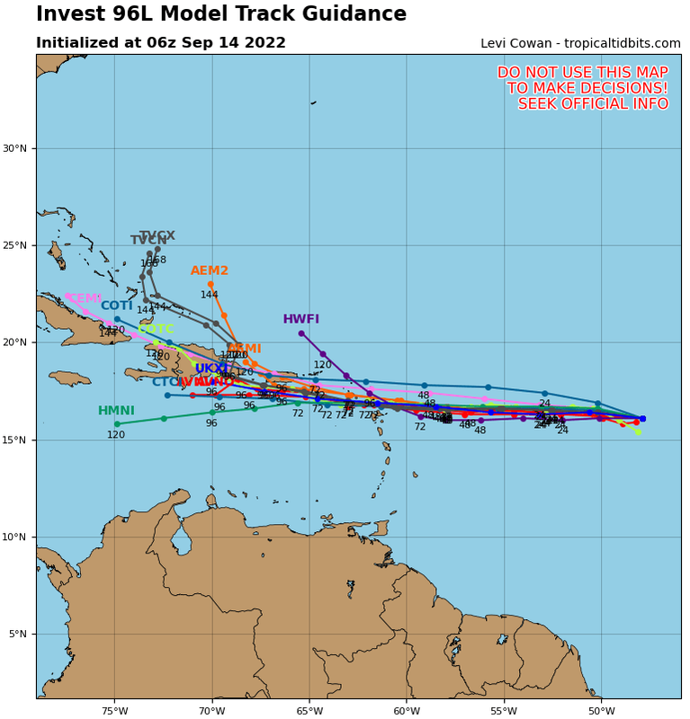
En otro orden esta es la primera proyeccion del 96L
-
StormWatch
- Cat. 3

- Posts: 3721
- Joined: Thu Aug 06, 2015 11:39 am
- Location: Texas, USA
Re: Invest 96L Atlantico Central 30%/40%
Hmmmmmmmmm direct HIT 
Member Since 2005
For official information, please refer to NHC: https://www.nhc.noaa.gov
Hurricane’s hit Puerto Rico:
San Felipe 1928, San Ciprián 1932, Santa Clara 1956, Hugo 1989, Marilyn 1995, Hortense 1996, Georges 1998, Maria 2017, Fiona 2022
Model Runs:
GFS:
[5:30 AM/PM, 11:30 AM/PM]
HWRF, GFDL, UKMET, NAVGEM:
[6:30-8:00 AM/PM, 12:30-2:00 AM/PM]
ECMWF:
[1:45 AM/PM]
-
StormWatch
- Cat. 3
- Posts: 3721
- Joined: Thu Aug 06, 2015 11:39 am
- Location: Texas, USA
Re: Invest 96L Atlantico Central 30%/40%
Member Since 2005
For official information, please refer to NHC: https://www.nhc.noaa.gov
Hurricane’s hit Puerto Rico:
San Felipe 1928, San Ciprián 1932, Santa Clara 1956, Hugo 1989, Marilyn 1995, Hortense 1996, Georges 1998, Maria 2017, Fiona 2022
Model Runs:
GFS:
[5:30 AM/PM, 11:30 AM/PM]
HWRF, GFDL, UKMET, NAVGEM:
[6:30-8:00 AM/PM, 12:30-2:00 AM/PM]
ECMWF:
[1:45 AM/PM]
For official information, please refer to NHC: https://www.nhc.noaa.gov
Hurricane’s hit Puerto Rico:
San Felipe 1928, San Ciprián 1932, Santa Clara 1956, Hugo 1989, Marilyn 1995, Hortense 1996, Georges 1998, Maria 2017, Fiona 2022
Model Runs:
GFS:
[5:30 AM/PM, 11:30 AM/PM]
HWRF, GFDL, UKMET, NAVGEM:
[6:30-8:00 AM/PM, 12:30-2:00 AM/PM]
ECMWF:
[1:45 AM/PM]

Re: Invest 96L Atlantico Central 30%/40%
Saludos a tod@s!
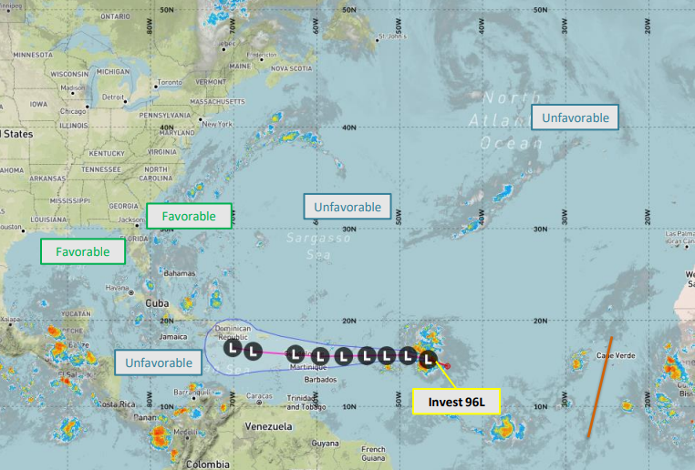
La ruta del 96L hay mucho consenso de que sería por nuestra área (PR)....Lo que hay que ver es si logra seguir manejando el aire seco y cuan fuerte serían los vientos cortantes que se pronostican una vez esté más cerca al Caribe. Si estos no son tan fuertes como se prevén pues tendríamos algo más fuerte en las puertas de nuestras casas.
Este escenario se me parece tanto a la Tormenta Tropical Jeanne, recuerdo que no se le daba prácticamente posibilidad de Desarrollo antes de llegar a PR y ya sabemos la historia...justo al entrar a PR estaba en el proceso de formación de un ojo entrando con vientos de 70mph a solo 4 millas de ser catalogado Huracán cat 1, curiosamente fue casi para la misma fecha, un 15 de septiembre entrando por Guayama PR.
Veremos como evoluciona todo y la naturaleza dictará. Mientras tanto nos mantenemos vigilantes!
-
StormWatch
- Cat. 3
- Posts: 3721
- Joined: Thu Aug 06, 2015 11:39 am
- Location: Texas, USA
Re: Invest 96L Atlantico Central 30%/40%
Hola PR, soy el Invest 96L
Voy de camino……….!! See y’all soon!
Voy de camino……….!! See y’all soon!
Member Since 2005
For official information, please refer to NHC: https://www.nhc.noaa.gov
Hurricane’s hit Puerto Rico:
San Felipe 1928, San Ciprián 1932, Santa Clara 1956, Hugo 1989, Marilyn 1995, Hortense 1996, Georges 1998, Maria 2017, Fiona 2022
Model Runs:
GFS:
[5:30 AM/PM, 11:30 AM/PM]
HWRF, GFDL, UKMET, NAVGEM:
[6:30-8:00 AM/PM, 12:30-2:00 AM/PM]
ECMWF:
[1:45 AM/PM]
For official information, please refer to NHC: https://www.nhc.noaa.gov
Hurricane’s hit Puerto Rico:
San Felipe 1928, San Ciprián 1932, Santa Clara 1956, Hugo 1989, Marilyn 1995, Hortense 1996, Georges 1998, Maria 2017, Fiona 2022
Model Runs:
GFS:
[5:30 AM/PM, 11:30 AM/PM]
HWRF, GFDL, UKMET, NAVGEM:
[6:30-8:00 AM/PM, 12:30-2:00 AM/PM]
ECMWF:
[1:45 AM/PM]
-
StormWatch
- Cat. 3
- Posts: 3721
- Joined: Thu Aug 06, 2015 11:39 am
- Location: Texas, USA
Re: Invest 96L Atlantico Central 30%/40%
Buenas, BUENAS! 
Member Since 2005
For official information, please refer to NHC: https://www.nhc.noaa.gov
Hurricane’s hit Puerto Rico:
San Felipe 1928, San Ciprián 1932, Santa Clara 1956, Hugo 1989, Marilyn 1995, Hortense 1996, Georges 1998, Maria 2017, Fiona 2022
Model Runs:
GFS:
[5:30 AM/PM, 11:30 AM/PM]
HWRF, GFDL, UKMET, NAVGEM:
[6:30-8:00 AM/PM, 12:30-2:00 AM/PM]
ECMWF:
[1:45 AM/PM]
For official information, please refer to NHC: https://www.nhc.noaa.gov
Hurricane’s hit Puerto Rico:
San Felipe 1928, San Ciprián 1932, Santa Clara 1956, Hugo 1989, Marilyn 1995, Hortense 1996, Georges 1998, Maria 2017, Fiona 2022
Model Runs:
GFS:
[5:30 AM/PM, 11:30 AM/PM]
HWRF, GFDL, UKMET, NAVGEM:
[6:30-8:00 AM/PM, 12:30-2:00 AM/PM]
ECMWF:
[1:45 AM/PM]
-
StormWatch
- Cat. 3
- Posts: 3721
- Joined: Thu Aug 06, 2015 11:39 am
- Location: Texas, USA
Re: Invest 96L Atlantico Central 30%/40%
Se humea algo cerca! Stay TUNE!

Member Since 2005
For official information, please refer to NHC: https://www.nhc.noaa.gov
Hurricane’s hit Puerto Rico:
San Felipe 1928, San Ciprián 1932, Santa Clara 1956, Hugo 1989, Marilyn 1995, Hortense 1996, Georges 1998, Maria 2017, Fiona 2022
Model Runs:
GFS:
[5:30 AM/PM, 11:30 AM/PM]
HWRF, GFDL, UKMET, NAVGEM:
[6:30-8:00 AM/PM, 12:30-2:00 AM/PM]
ECMWF:
[1:45 AM/PM]
For official information, please refer to NHC: https://www.nhc.noaa.gov
Hurricane’s hit Puerto Rico:
San Felipe 1928, San Ciprián 1932, Santa Clara 1956, Hugo 1989, Marilyn 1995, Hortense 1996, Georges 1998, Maria 2017, Fiona 2022
Model Runs:
GFS:
[5:30 AM/PM, 11:30 AM/PM]
HWRF, GFDL, UKMET, NAVGEM:
[6:30-8:00 AM/PM, 12:30-2:00 AM/PM]
ECMWF:
[1:45 AM/PM]
Re: Invest 96L Atlantico Central 30%/40%
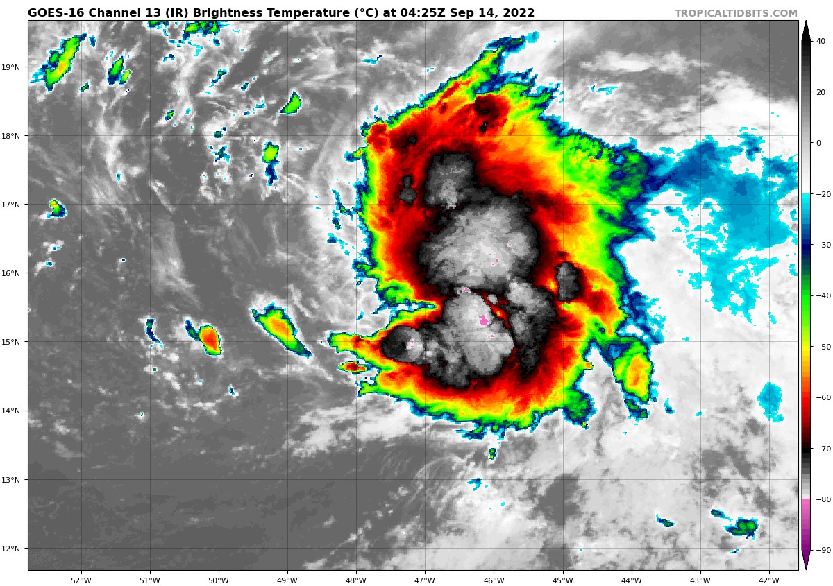
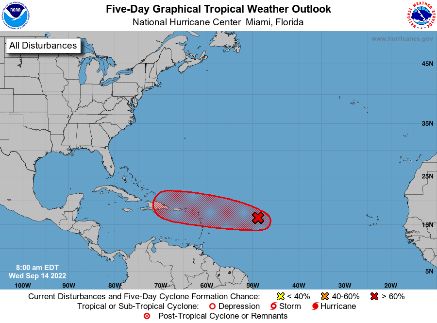
Las cosas se estan poniendo algo peligrosas
ZCZC MIATWOAT ALL
TTAA00 KNHC DDHHMM
Tropical Weather Outlook
NWS National Hurricane Center Miami FL
800 AM EDT Wed Sep 14 2022
For the North Atlantic...Caribbean Sea and the Gulf of Mexico:
1. Central Tropical Atlantic:
Showers and thunderstorms associated with a broad and elongated
area of low pressure located about 800 miles east of the Lesser
Antilles have persisted overnight and are showing signs of
organization. Although upper-level winds are not particularly
conducive for additional development, only a slight increase in
organization would result in the formation of a tropical
depression. The system is forecast to move generally westward
over the tropical Atlantic during the next day or so, and move
near or over portions of the Leeward Islands Friday and Friday
night. Regardless of development, the system is likely to bring
gusty winds and locally heavy rainfall to portions of the Leeward
Islands Friday through Saturday. Interests in the Leeward Islands,
the Virgin Islands, and Puerto Rico should monitor the progress of
this system.
* Formation chance through 48 hours...high...70 percent.
* Formation chance through 5 days...high...70 percent.
Forecaster Brown
-
StormWatch
- Cat. 3
- Posts: 3721
- Joined: Thu Aug 06, 2015 11:39 am
- Location: Texas, USA
Re: Invest 96L Atlantico Central 30%/40%
El administrador que esta pasando?
Despierta BORICUA!
70-70
Despierta BORICUA!
70-70
Member Since 2005
For official information, please refer to NHC: https://www.nhc.noaa.gov
Hurricane’s hit Puerto Rico:
San Felipe 1928, San Ciprián 1932, Santa Clara 1956, Hugo 1989, Marilyn 1995, Hortense 1996, Georges 1998, Maria 2017, Fiona 2022
Model Runs:
GFS:
[5:30 AM/PM, 11:30 AM/PM]
HWRF, GFDL, UKMET, NAVGEM:
[6:30-8:00 AM/PM, 12:30-2:00 AM/PM]
ECMWF:
[1:45 AM/PM]
For official information, please refer to NHC: https://www.nhc.noaa.gov
Hurricane’s hit Puerto Rico:
San Felipe 1928, San Ciprián 1932, Santa Clara 1956, Hugo 1989, Marilyn 1995, Hortense 1996, Georges 1998, Maria 2017, Fiona 2022
Model Runs:
GFS:
[5:30 AM/PM, 11:30 AM/PM]
HWRF, GFDL, UKMET, NAVGEM:
[6:30-8:00 AM/PM, 12:30-2:00 AM/PM]
ECMWF:
[1:45 AM/PM]