

Gracias!BAYANEY wrote: ↑Mon Sep 13, 2021 9:00 am Comparación del modelo ECMWF de María hacen 4 años para la misma fecha.
http://imgur.com/gallery/lFjSLMN
Tormenta Tropical Peter
Re: INVEST 95L


Re: INVEST 95L
Diantre!!! Uuyyyyymegadicto wrote: ↑Mon Sep 13, 2021 4:16 pmGracias!BAYANEY wrote: ↑Mon Sep 13, 2021 9:00 am Comparación del modelo ECMWF de María hacen 4 años para la misma fecha.
http://imgur.com/gallery/lFjSLMN
 , aunque sabemos que atmosférica mente hablando son diferentes, pero no deja de ser curioso como los modelos se equivocan, lo mismo pasó con el 93l y el europeo, los modelos son guías pero las variables muchas y cambiantes se equivocan muchas veces.

-
StormWatch
- Cat. 3

- Posts: 3721
- Joined: Thu Aug 06, 2015 11:39 am
- Location: Texas, USA
Re: INVEST 95L
 Si el año pasa'o tuvimos problemas,
quizás este año tengamos más..
Si el año pasa'o tuvimos problemas
quizás este año tengamos más
Wepaaaaaaaaa! 95L pronto entrará completamente al agua…
STAY TUNEEEEEE!

Member Since 2005
For official information, please refer to NHC: https://www.nhc.noaa.gov
Hurricane’s hit Puerto Rico:
San Felipe 1928, San Ciprián 1932, Santa Clara 1956, Hugo 1989, Marilyn 1995, Hortense 1996, Georges 1998, Maria 2017, Fiona 2022
Model Runs:
GFS:
[5:30 AM/PM, 11:30 AM/PM]
HWRF, GFDL, UKMET, NAVGEM:
[6:30-8:00 AM/PM, 12:30-2:00 AM/PM]
ECMWF:
[1:45 AM/PM]
Re: INVEST 95L
Tropical Weather Outlook
NWS National Hurricane Center Miami FL
800 PM EDT Mon Sep 13 2021
For the North Atlantic...Caribbean Sea and the Gulf of Mexico:
The National Hurricane Center is issuing advisories on Tropical
Storm Nicholas, located near the central Texas coast.
1. A tropical wave located over the far eastern tropical Atlantic is
producing an area of disorganized cloudiness and thunderstorms.
Environmental conditions are forecast to be conducive for gradual
development of this disturbance over the next several days, and a
tropical depression is likely to form by later this week while the
system moves westward at about 15 mph across the eastern tropical
Atlantic Ocean.
* Formation chance through 48 hours...medium...40 percent.
* Formation chance through 5 days...high...80 percent.
-
StormWatch
- Cat. 3
- Posts: 3721
- Joined: Thu Aug 06, 2015 11:39 am
- Location: Texas, USA
Re: INVEST 95L
Nada mal!StormWatch wrote: ↑Mon Sep 13, 2021 6:36 pmSi el año pasa'o tuvimos problemas,
quizás este año tengamos más..
Si el año pasa'o tuvimos problemas
quizás este año tengamos más
Wepaaaaaaaaa! 95L pronto entrará completamente al agua…
STAY TUNEEEEEE!
Member Since 2005
For official information, please refer to NHC: https://www.nhc.noaa.gov
Hurricane’s hit Puerto Rico:
San Felipe 1928, San Ciprián 1932, Santa Clara 1956, Hugo 1989, Marilyn 1995, Hortense 1996, Georges 1998, Maria 2017, Fiona 2022
Model Runs:
GFS:
[5:30 AM/PM, 11:30 AM/PM]
HWRF, GFDL, UKMET, NAVGEM:
[6:30-8:00 AM/PM, 12:30-2:00 AM/PM]
ECMWF:
[1:45 AM/PM]
For official information, please refer to NHC: https://www.nhc.noaa.gov
Hurricane’s hit Puerto Rico:
San Felipe 1928, San Ciprián 1932, Santa Clara 1956, Hugo 1989, Marilyn 1995, Hortense 1996, Georges 1998, Maria 2017, Fiona 2022
Model Runs:
GFS:
[5:30 AM/PM, 11:30 AM/PM]
HWRF, GFDL, UKMET, NAVGEM:
[6:30-8:00 AM/PM, 12:30-2:00 AM/PM]
ECMWF:
[1:45 AM/PM]
-
StormWatch
- Cat. 3
- Posts: 3721
- Joined: Thu Aug 06, 2015 11:39 am
- Location: Texas, USA
Re: INVEST 95L
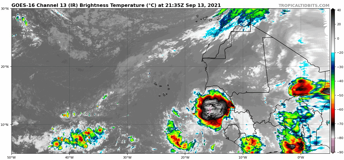
Imagen actual del Invest 95L
Clase PELOTA DE SISTEMA!

Clase PELOTA DE SISTEMA!
Member Since 2005
For official information, please refer to NHC: https://www.nhc.noaa.gov
Hurricane’s hit Puerto Rico:
San Felipe 1928, San Ciprián 1932, Santa Clara 1956, Hugo 1989, Marilyn 1995, Hortense 1996, Georges 1998, Maria 2017, Fiona 2022
Model Runs:
GFS:
[5:30 AM/PM, 11:30 AM/PM]
HWRF, GFDL, UKMET, NAVGEM:
[6:30-8:00 AM/PM, 12:30-2:00 AM/PM]
ECMWF:
[1:45 AM/PM]
For official information, please refer to NHC: https://www.nhc.noaa.gov
Hurricane’s hit Puerto Rico:
San Felipe 1928, San Ciprián 1932, Santa Clara 1956, Hugo 1989, Marilyn 1995, Hortense 1996, Georges 1998, Maria 2017, Fiona 2022
Model Runs:
GFS:
[5:30 AM/PM, 11:30 AM/PM]
HWRF, GFDL, UKMET, NAVGEM:
[6:30-8:00 AM/PM, 12:30-2:00 AM/PM]
ECMWF:
[1:45 AM/PM]
-
StormWatch
- Cat. 3
- Posts: 3721
- Joined: Thu Aug 06, 2015 11:39 am
- Location: Texas, USA
Re: INVEST 95L
Me encanta esta foto!
Al fondo el 95L……!!
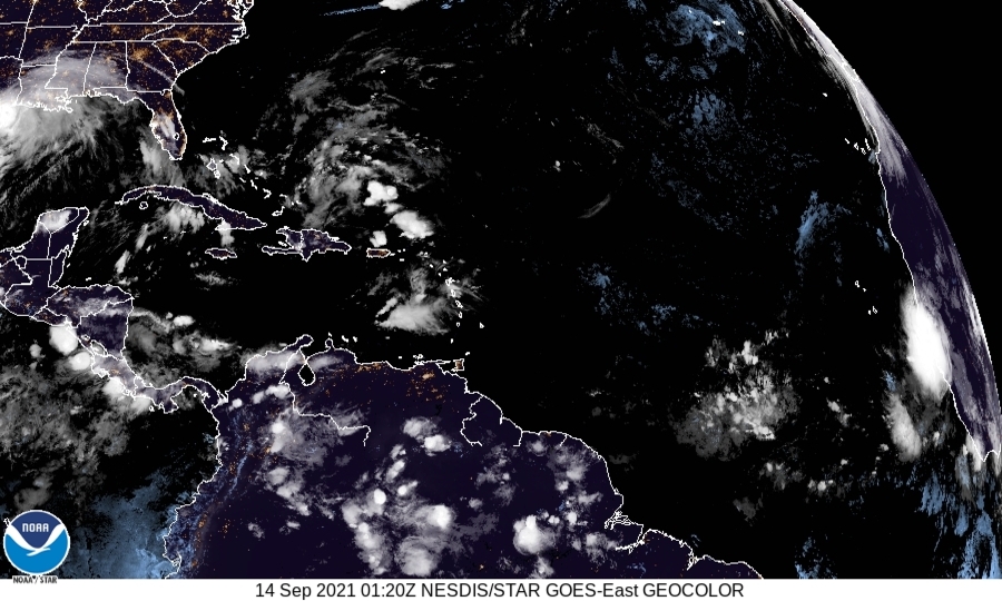
Al fondo el 95L……!!
Member Since 2005
For official information, please refer to NHC: https://www.nhc.noaa.gov
Hurricane’s hit Puerto Rico:
San Felipe 1928, San Ciprián 1932, Santa Clara 1956, Hugo 1989, Marilyn 1995, Hortense 1996, Georges 1998, Maria 2017, Fiona 2022
Model Runs:
GFS:
[5:30 AM/PM, 11:30 AM/PM]
HWRF, GFDL, UKMET, NAVGEM:
[6:30-8:00 AM/PM, 12:30-2:00 AM/PM]
ECMWF:
[1:45 AM/PM]
For official information, please refer to NHC: https://www.nhc.noaa.gov
Hurricane’s hit Puerto Rico:
San Felipe 1928, San Ciprián 1932, Santa Clara 1956, Hugo 1989, Marilyn 1995, Hortense 1996, Georges 1998, Maria 2017, Fiona 2022
Model Runs:
GFS:
[5:30 AM/PM, 11:30 AM/PM]
HWRF, GFDL, UKMET, NAVGEM:
[6:30-8:00 AM/PM, 12:30-2:00 AM/PM]
ECMWF:
[1:45 AM/PM]
Re: INVEST 95L
Ha mantenido una muy buena conveccionStormWatch wrote: ↑Mon Sep 13, 2021 9:40 pmNada mal!StormWatch wrote: ↑Mon Sep 13, 2021 6:36 pm
quizás este año tengamos más..
Si el año pasa'o tuvimos problemas
quizás este año tengamos más
Wepaaaaaaaaa! 95L pronto entrará completamente al agua…
STAY TUNEEEEEE!
Aqui la corrida de las 00z
