

Depression Tropical Josephine
-
StormWatch
- Cat. 3

- Posts: 3721
- Joined: Thu Aug 06, 2015 11:39 am
- Location: Texas, USA
Re: Invest 95L - Onda tropical al este de las Antillas Menores 90-90%
Trayectoria oficial!
Member Since 2005
For official information, please refer to NHC: https://www.nhc.noaa.gov
Hurricane’s hit Puerto Rico:
San Felipe 1928, San Ciprián 1932, Santa Clara 1956, Hugo 1989, Marilyn 1995, Hortense 1996, Georges 1998, Maria 2017, Fiona 2022
Model Runs:
GFS:
[5:30 AM/PM, 11:30 AM/PM]
HWRF, GFDL, UKMET, NAVGEM:
[6:30-8:00 AM/PM, 12:30-2:00 AM/PM]
ECMWF:
[1:45 AM/PM]
-
hurrizonepr
- Depresión Tropical

- Posts: 451
- Joined: Wed Sep 04, 2013 10:30 am
Re: Depresión Tropical # 11 al este de las Antillas Menores
BULLETIN
Tropical Depression Eleven Advisory Number 1
NWS National Hurricane Center Miami FL AL112020
500 PM AST Tue Aug 11 2020
...NEW TROPICAL DEPRESSION FORMS OVER THE TROPICAL ATLANTIC OCEAN...
SUMMARY OF 500 PM AST...2100 UTC...INFORMATION
----------------------------------------------
LOCATION...11.7N 40.0W
ABOUT 1110 MI...1790 KM WSW OF THE CABO VERDE ISLANDS
ABOUT 1450 MI...2335 KM E OF THE LESSER ANTILLES
MAXIMUM SUSTAINED WINDS...35 MPH...55 KM/H
PRESENT MOVEMENT...W OR 280 DEGREES AT 16 MPH...26 KM/H
MINIMUM CENTRAL PRESSURE...1007 MB...29.74 INCHES
WATCHES AND WARNINGS
--------------------
There are no coastal watches or warnings in effect.
DISCUSSION AND OUTLOOK
----------------------
At 500 PM AST (2100 UTC), the center of Tropical Depression Eleven
was located near latitude 11.7 North, longitude 40.0 West. The
depression is moving toward the west near 16 mph (26 km/h), and this
general motion is expected to continue through Wednesday. A
west-northwestward motion at a similar forward speed is forecast to
begin Wednesday night and continue through the rest of the week.
Maximum sustained winds are near 35 mph (55 km/h) with higher gusts.
Some strengthening is forecast during the next 48 hours, and the
depression is expected to become a tropical storm by Wednesday
night.
The estimated minimum central pressure is 1007 mb (29.74 inches).
HAZARDS AFFECTING LAND
----------------------
None
Last edited by hurrizonepr on Tue Aug 11, 2020 10:05 pm, edited 1 time in total.

Re: Depresión Tropical # 11 al este de las Antillas Menores 90-90%
Saludos a Todos!!! Las tronadas a esta hora tapando el centro de circulación de la Depresión Tropical #11 cerca de la 12n y su movimiento se ve que es west, veremos que pasará cuando n este sistema, entre mas al sur con movimiento oeste se mantenga se podría acercar al Caribe y por ende hay que vigilar de cerca estos tipos de sistemas que batallarán aunque las condiciones no sean la mejore. Veremos
-
StormWatch
- Cat. 3
- Posts: 3721
- Joined: Thu Aug 06, 2015 11:39 am
- Location: Texas, USA
Re: Invest 95L - Onda tropical al suroeste de Cabo Verde 40%-50%
Aquí el link!

Sorry! Perdón por lo tarde!
https://www.tropicaltidbits.com/sat/sat ... product=ir
Member Since 2005
For official information, please refer to NHC: https://www.nhc.noaa.gov
Hurricane’s hit Puerto Rico:
San Felipe 1928, San Ciprián 1932, Santa Clara 1956, Hugo 1989, Marilyn 1995, Hortense 1996, Georges 1998, Maria 2017, Fiona 2022
Model Runs:
GFS:
[5:30 AM/PM, 11:30 AM/PM]
HWRF, GFDL, UKMET, NAVGEM:
[6:30-8:00 AM/PM, 12:30-2:00 AM/PM]
ECMWF:
[1:45 AM/PM]
For official information, please refer to NHC: https://www.nhc.noaa.gov
Hurricane’s hit Puerto Rico:
San Felipe 1928, San Ciprián 1932, Santa Clara 1956, Hugo 1989, Marilyn 1995, Hortense 1996, Georges 1998, Maria 2017, Fiona 2022
Model Runs:
GFS:
[5:30 AM/PM, 11:30 AM/PM]
HWRF, GFDL, UKMET, NAVGEM:
[6:30-8:00 AM/PM, 12:30-2:00 AM/PM]
ECMWF:
[1:45 AM/PM]
-
StormWatch
- Cat. 3
- Posts: 3721
- Joined: Thu Aug 06, 2015 11:39 am
- Location: Texas, USA
Re: Depresión Tropical # 11 al este de las Antillas Menores
Este sistema no se le ven bandas en espiral y la está pasando mal ahora mismo según veo el visible.
Member Since 2005
For official information, please refer to NHC: https://www.nhc.noaa.gov
Hurricane’s hit Puerto Rico:
San Felipe 1928, San Ciprián 1932, Santa Clara 1956, Hugo 1989, Marilyn 1995, Hortense 1996, Georges 1998, Maria 2017, Fiona 2022
Model Runs:
GFS:
[5:30 AM/PM, 11:30 AM/PM]
HWRF, GFDL, UKMET, NAVGEM:
[6:30-8:00 AM/PM, 12:30-2:00 AM/PM]
ECMWF:
[1:45 AM/PM]
For official information, please refer to NHC: https://www.nhc.noaa.gov
Hurricane’s hit Puerto Rico:
San Felipe 1928, San Ciprián 1932, Santa Clara 1956, Hugo 1989, Marilyn 1995, Hortense 1996, Georges 1998, Maria 2017, Fiona 2022
Model Runs:
GFS:
[5:30 AM/PM, 11:30 AM/PM]
HWRF, GFDL, UKMET, NAVGEM:
[6:30-8:00 AM/PM, 12:30-2:00 AM/PM]
ECMWF:
[1:45 AM/PM]
-
StormWatch
- Cat. 3
- Posts: 3721
- Joined: Thu Aug 06, 2015 11:39 am
- Location: Texas, USA
Re: Depresión Tropical # 11 al este de las Antillas Menores
Via CycloforumPR
[DT#11 11PM]
El pronóstico de intensidad fue aumentado levemente, ahora estimando que podría subir a 60 mph, según se debiliten los vientos alisios y ello permita el crecimiento de convección. Por eso, la ruta ha sido alejada levemente. Más débil, más al oeste.
[DT#11 11PM]
El pronóstico de intensidad fue aumentado levemente, ahora estimando que podría subir a 60 mph, según se debiliten los vientos alisios y ello permita el crecimiento de convección. Por eso, la ruta ha sido alejada levemente. Más débil, más al oeste.
Member Since 2005
For official information, please refer to NHC: https://www.nhc.noaa.gov
Hurricane’s hit Puerto Rico:
San Felipe 1928, San Ciprián 1932, Santa Clara 1956, Hugo 1989, Marilyn 1995, Hortense 1996, Georges 1998, Maria 2017, Fiona 2022
Model Runs:
GFS:
[5:30 AM/PM, 11:30 AM/PM]
HWRF, GFDL, UKMET, NAVGEM:
[6:30-8:00 AM/PM, 12:30-2:00 AM/PM]
ECMWF:
[1:45 AM/PM]
For official information, please refer to NHC: https://www.nhc.noaa.gov
Hurricane’s hit Puerto Rico:
San Felipe 1928, San Ciprián 1932, Santa Clara 1956, Hugo 1989, Marilyn 1995, Hortense 1996, Georges 1998, Maria 2017, Fiona 2022
Model Runs:
GFS:
[5:30 AM/PM, 11:30 AM/PM]
HWRF, GFDL, UKMET, NAVGEM:
[6:30-8:00 AM/PM, 12:30-2:00 AM/PM]
ECMWF:
[1:45 AM/PM]
-
StormWatch
- Cat. 3
- Posts: 3721
- Joined: Thu Aug 06, 2015 11:39 am
- Location: Texas, USA
Re: Depresión Tropical # 11 al este de las Antillas Menores
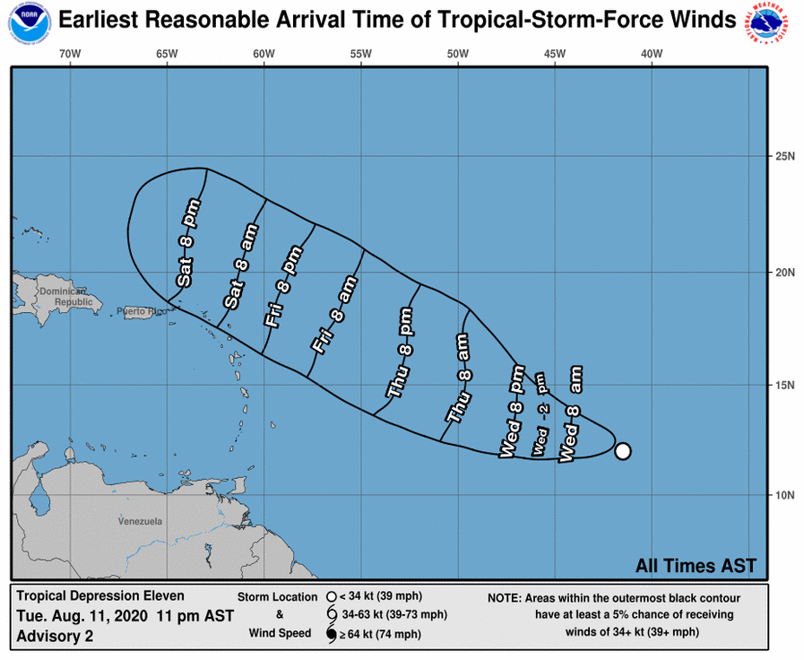
Trayectoria oficial de la Depresión #11, según el NHC a las 11pm

Member Since 2005
For official information, please refer to NHC: https://www.nhc.noaa.gov
Hurricane’s hit Puerto Rico:
San Felipe 1928, San Ciprián 1932, Santa Clara 1956, Hugo 1989, Marilyn 1995, Hortense 1996, Georges 1998, Maria 2017, Fiona 2022
Model Runs:
GFS:
[5:30 AM/PM, 11:30 AM/PM]
HWRF, GFDL, UKMET, NAVGEM:
[6:30-8:00 AM/PM, 12:30-2:00 AM/PM]
ECMWF:
[1:45 AM/PM]
For official information, please refer to NHC: https://www.nhc.noaa.gov
Hurricane’s hit Puerto Rico:
San Felipe 1928, San Ciprián 1932, Santa Clara 1956, Hugo 1989, Marilyn 1995, Hortense 1996, Georges 1998, Maria 2017, Fiona 2022
Model Runs:
GFS:
[5:30 AM/PM, 11:30 AM/PM]
HWRF, GFDL, UKMET, NAVGEM:
[6:30-8:00 AM/PM, 12:30-2:00 AM/PM]
ECMWF:
[1:45 AM/PM]
-
hurrizonepr
- Depresión Tropical
- Posts: 451
- Joined: Wed Sep 04, 2013 10:30 am
Re: Depresión Tropical # 11 al este de las Antillas Menores
Boletín 5am:
BULLETIN
Tropical Depression Eleven Advisory Number 3
NWS National Hurricane Center Miami FL AL112020
500 AM AST Wed Aug 12 2020
...DEPRESSION EXPECTED TO BECOME A TROPICAL STORM LATER TODAY...
SUMMARY OF 500 AM AST...0900 UTC...INFORMATION
----------------------------------------------
LOCATION...12.2N 42.9W
ABOUT 1405 MI...2265 KM ESE OF THE NORTHERN LEEWARD ISLANDS
MAXIMUM SUSTAINED WINDS...35 MPH...55 KM/H
PRESENT MOVEMENT...W OR 280 DEGREES AT 15 MPH...24 KM/H
MINIMUM CENTRAL PRESSURE...1008 MB...29.77 INCHES
WATCHES AND WARNINGS
--------------------
There are no coastal watches or warnings in effect.
DISCUSSION AND OUTLOOK
----------------------
At 500 AM AST (0900 UTC), the center of Tropical Depression Eleven
was located near latitude 12.2 North, longitude 42.9 West. The
depression is moving toward the west near 15 mph (24 km/h), and this
general motion is expected to continue through today. A motion
toward the west-northwest at a similar forward speed is forecast to
begin tonight and continue through the rest of the week.
Maximum sustained winds are near 35 mph (55 km/h) with higher gusts.
Gradual strengthening is forecast during the next 48 hours, and the
depression is expected to become a tropical storm later today.
The estimated minimum central pressure is 1008 mb (29.77 inches).
HAZARDS AFFECTING LAND
----------------------
None.
NEXT ADVISORY
-------------
Next complete advisory at 1100 AM AST.
$$
Forecaster Stewart
-
hurrizonepr
- Depresión Tropical
- Posts: 451
- Joined: Wed Sep 04, 2013 10:30 am
Re: Depresión Tropical # 11 al este de las Antillas Menores
11am:
BULLETIN
Tropical Depression Eleven Advisory Number 4
NWS National Hurricane Center Miami FL AL112020
1100 AM AST Wed Aug 12 2020
...DEPRESSION REMAINS JUST BELOW TROPICAL STORM STRENGTH...
SUMMARY OF 1100 AM AST...1500 UTC...INFORMATION
-----------------------------------------------
LOCATION...12.4N 44.2W
ABOUT 1320 MI...2125 KM ESE OF THE NORTHERN LEEWARD ISLANDS
MAXIMUM SUSTAINED WINDS...35 MPH...55 KM/H
PRESENT MOVEMENT...W OR 280 DEGREES AT 14 MPH...22 KM/H
MINIMUM CENTRAL PRESSURE...1007 MB...29.74 INCHES
WATCHES AND WARNINGS
--------------------
There are no coastal watches or warnings in effect.
DISCUSSION AND OUTLOOK
----------------------
At 1100 AM AST (1500 UTC), the center of Tropical Depression Eleven
was located near latitude 12.4 North, longitude 44.2 West. The
depression is moving toward the west near 14 mph (22 km/h), and this
general motion is expected to continue today. A turn toward the
west-northwest at a similar forward speed is expected tonight, with
this motion continuing through the rest of the week.
Maximum sustained winds are near 35 mph (55 km/h) with higher gusts.
Gradual strengthening is forecast during the next 48 hours, and the
depression is expected to become a tropical storm later today.
The estimated minimum central pressure is 1007 mb (29.74 inches).
HAZARDS AFFECTING LAND
----------------------
None.
NEXT ADVISORY
-------------
Next complete advisory at 500 PM AST.
$$
Forecaster Beven
-
StormWatch
- Cat. 3
- Posts: 3721
- Joined: Thu Aug 06, 2015 11:39 am
- Location: Texas, USA
Re: Depresión Tropical # 11 al este de las Antillas Menores
Muchísimo mejor durante el día de hoy, ya tiene esas bandas en espiral clásico de la S....

Member Since 2005
For official information, please refer to NHC: https://www.nhc.noaa.gov
Hurricane’s hit Puerto Rico:
San Felipe 1928, San Ciprián 1932, Santa Clara 1956, Hugo 1989, Marilyn 1995, Hortense 1996, Georges 1998, Maria 2017, Fiona 2022
Model Runs:
GFS:
[5:30 AM/PM, 11:30 AM/PM]
HWRF, GFDL, UKMET, NAVGEM:
[6:30-8:00 AM/PM, 12:30-2:00 AM/PM]
ECMWF:
[1:45 AM/PM]
For official information, please refer to NHC: https://www.nhc.noaa.gov
Hurricane’s hit Puerto Rico:
San Felipe 1928, San Ciprián 1932, Santa Clara 1956, Hugo 1989, Marilyn 1995, Hortense 1996, Georges 1998, Maria 2017, Fiona 2022
Model Runs:
GFS:
[5:30 AM/PM, 11:30 AM/PM]
HWRF, GFDL, UKMET, NAVGEM:
[6:30-8:00 AM/PM, 12:30-2:00 AM/PM]
ECMWF:
[1:45 AM/PM]