
Tormenta tropical Isaias


Re: Invest 92L (PTC#9) al este de la Antillas con 80%/90%
Parece reformar el centro and al sur todavía. Por el momento puede que la distancia al sur sea de hasta 80 millas a PR. No significa que no sea evento de lluvias pero los vientos deben ser menos intensos.
Siempre recuerden esto:
Los sistemas tropicales no se mueven en linea recta, se mueven es "zig-zag", o oscilaciones. Es normal que este a 290 grados y de momento vaya a 270 grados, esto hace un promedio de 280 grados, lo cual es Oeste-Noroeste. Es normal.
Los sistemas tropicales no se mueven en linea recta, se mueven es "zig-zag", o oscilaciones. Es normal que este a 290 grados y de momento vaya a 270 grados, esto hace un promedio de 280 grados, lo cual es Oeste-Noroeste. Es normal.

Re: Invest 92L (PTC#9) al este de la Antillas con 80%/90%
Saludos Carlos
Solo le temo a la lluvia y no tanto anlos vientos sienore y cuando estes bien guardado.
Hay que darle gracias a Dios que el resultado neto sea agua...excelente. PR no aguanta otra tragedia mas....
Aprovecha que PF Aguadilla aumentó la producción para mantener por mas tiempo el servicio de agua potable para tu area
Disclaimer: "Solo soy otro fan de la meteorolgia...para informacion mas precisa vaya a buscarla del NHC y del SNM.... No soy la voz oficial de comunicaciones de la AAA asi que pendiente a sus anuncios oficiales en los medios de comunicación de prensa escrita, radial, televisiva, redes socials, etc."


Re: Invest 92L (PTC#9) al este de la Antillas con 80%/90%
Saludos camaradas.
Y el centro donde andara?
Sera eso que se ve en el radar de Meteo Oeste de Guadalupe?
Y el centro donde andara?
Sera eso que se ve en el radar de Meteo Oeste de Guadalupe?
-
StormWatch
- Cat. 3

- Posts: 3721
- Joined: Thu Aug 06, 2015 11:39 am
- Location: Texas, USA
Re: Invest 92L (PTC#9) al este de la Antillas con 80%/90%
BOMMMM!
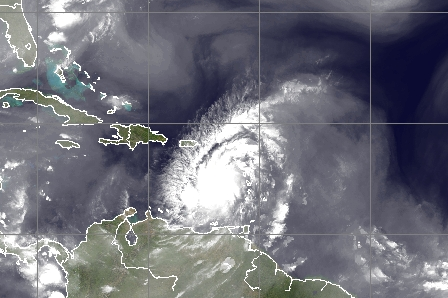
Beginning to see evidence of a better defined circulation developing with #PTC9. Radar from barbadosweather.org shows obvious cyclonic rotation as the system moves into the Caribbean. Some evidence of a center around 16N/63W.

Beginning to see evidence of a better defined circulation developing with #PTC9. Radar from barbadosweather.org shows obvious cyclonic rotation as the system moves into the Caribbean. Some evidence of a center around 16N/63W.
Member Since 2005
For official information, please refer to NHC: https://www.nhc.noaa.gov
Hurricane’s hit Puerto Rico:
San Felipe 1928, San Ciprián 1932, Santa Clara 1956, Hugo 1989, Marilyn 1995, Hortense 1996, Georges 1998, Maria 2017, Fiona 2022
Model Runs:
GFS:
[5:30 AM/PM, 11:30 AM/PM]
HWRF, GFDL, UKMET, NAVGEM:
[6:30-8:00 AM/PM, 12:30-2:00 AM/PM]
ECMWF:
[1:45 AM/PM]
Re: Invest 92L (PTC#9) al este de la Antillas con 80%/90%
Todos sus vientos fuertes se encuentran al Norte
Re: Invest 92L (PTC#9) al este de la Antillas con 80%/90%
Time: 14:18:00Z
Coordinates: 16.633N 64.717W
Acft. Static Air Press: 923.1 mb
Acft. Geopotential Hgt: 785 m (2,575 ft)
Extrap. Sfc. Press: 1009.6 mb (29.82 inHg)
Flt. Lvl. Wind (30s): From 45° at 37 kts (From the NE at 42.6 mph)
Air Temp: 21.6°C (70.9°F)
Dew Pt: 19.5°C (67.1°F)
Peak (10s) Flt. Lvl. Wind: 38 kts (43.7 mph)
SFMR Peak (10s) Sfc. Wind: 30 kts (34.5 mph)
SFMR Rain Rate: 0 mm/hr
-
StormWatch
- Cat. 3
- Posts: 3721
- Joined: Thu Aug 06, 2015 11:39 am
- Location: Texas, USA
Re: Invest 92L (PTC#9) al este de la Antillas con 80%/90%
Que GRANDE!
Member Since 2005
For official information, please refer to NHC: https://www.nhc.noaa.gov
Hurricane’s hit Puerto Rico:
San Felipe 1928, San Ciprián 1932, Santa Clara 1956, Hugo 1989, Marilyn 1995, Hortense 1996, Georges 1998, Maria 2017, Fiona 2022
Model Runs:
GFS:
[5:30 AM/PM, 11:30 AM/PM]
HWRF, GFDL, UKMET, NAVGEM:
[6:30-8:00 AM/PM, 12:30-2:00 AM/PM]
ECMWF:
[1:45 AM/PM]
For official information, please refer to NHC: https://www.nhc.noaa.gov
Hurricane’s hit Puerto Rico:
San Felipe 1928, San Ciprián 1932, Santa Clara 1956, Hugo 1989, Marilyn 1995, Hortense 1996, Georges 1998, Maria 2017, Fiona 2022
Model Runs:
GFS:
[5:30 AM/PM, 11:30 AM/PM]
HWRF, GFDL, UKMET, NAVGEM:
[6:30-8:00 AM/PM, 12:30-2:00 AM/PM]
ECMWF:
[1:45 AM/PM]
-
hurrizonepr
- Depresión Tropical

- Posts: 451
- Joined: Wed Sep 04, 2013 10:30 am
Re: Invest 92L (PTC#9) al este de la Antillas con 80%/90%
Me parece que a las 11 tendrá nombre.
-
StormWatch
- Cat. 3
- Posts: 3721
- Joined: Thu Aug 06, 2015 11:39 am
- Location: Texas, USA
Re: Invest 92L (PTC#9) al este de la Antillas con 80%/90%
Todavía!!!

Member Since 2005
For official information, please refer to NHC: https://www.nhc.noaa.gov
Hurricane’s hit Puerto Rico:
San Felipe 1928, San Ciprián 1932, Santa Clara 1956, Hugo 1989, Marilyn 1995, Hortense 1996, Georges 1998, Maria 2017, Fiona 2022
Model Runs:
GFS:
[5:30 AM/PM, 11:30 AM/PM]
HWRF, GFDL, UKMET, NAVGEM:
[6:30-8:00 AM/PM, 12:30-2:00 AM/PM]
ECMWF:
[1:45 AM/PM]
For official information, please refer to NHC: https://www.nhc.noaa.gov
Hurricane’s hit Puerto Rico:
San Felipe 1928, San Ciprián 1932, Santa Clara 1956, Hugo 1989, Marilyn 1995, Hortense 1996, Georges 1998, Maria 2017, Fiona 2022
Model Runs:
GFS:
[5:30 AM/PM, 11:30 AM/PM]
HWRF, GFDL, UKMET, NAVGEM:
[6:30-8:00 AM/PM, 12:30-2:00 AM/PM]
ECMWF:
[1:45 AM/PM]
-
hurrizonepr
- Depresión Tropical
- Posts: 451
- Joined: Wed Sep 04, 2013 10:30 am
Re: Invest 92L (PTC#9) al este de la Antillas con 80%/90%
WTNT34 KNHC 291449
TCPAT4
BULLETIN
Potential Tropical Cyclone Nine Advisory Number 5
NWS National Hurricane Center Miami FL AL092020
1100 AM AST Wed Jul 29 2020
...HEAVY RAINFALL AND GUSTY WINDS CONTINUE TO SPREAD OVER THE
LEEWARD ISLANDS...
SUMMARY OF 1100 AM AST...1500 UTC...INFORMATION
-----------------------------------------------
LOCATION...15.8N 63.7W
ABOUT 150 MI...240 KM SSE OF ST. CROIX
ABOUT 240 MI...385 KM SE OF SAN JUAN PUERTO RICO
MAXIMUM SUSTAINED WINDS...45 MPH...75 KM/H
PRESENT MOVEMENT...WNW OR 290 DEGREES AT 23 MPH...37 KM/H
MINIMUM CENTRAL PRESSURE...1006 MB...29.71 INCHES
WATCHES AND WARNINGS
--------------------
CHANGES WITH THIS ADVISORY:
The government of the Bahamas has issued a Tropical Storm Warning
for the southeast Bahamas and Turks and Caicos Islands. The
government of the Bahamas has also issued a Tropical Storm Watch
for the central Bahamas.
SUMMARY OF WATCHES AND WARNINGS IN EFFECT:
A Tropical Storm Warning is in effect for...
* Puerto Rico, Vieques, Culebra
* U.S. Virgin Islands
* British Virgin Islands
* Antigua, Barbuda, Montserrat, St. Kitts, Nevis, and Anguilla
* Guadeloupe, Martinique, St. Martin, and St. Barthelemy
* Saba and St. Eustatius
* St. Maarten
* Dominican Republic from Cabo Caucedo eastward to Cabo Engano and
then westward along the northern coast to the Dominican
Republic/Haiti border
* North coast of Haiti from Le Mole St Nicholas eastward to the
northern border with the Dominican Republic
* Turks and Caicos Islands
* Southeastern Bahamas including the Acklins, Crooked Island, Long
Cay, the Inaguas, Mayaguana, and the Ragged Islands
A Tropical Storm Watch is in effect for...
* Dominican Republic from the southern Haiti border eastward to
Cabo Caucedo
* Central Bahamas, including Cat Island, the Exumas, Long Island,
Rum Cay, and San Salvador
Interests in the northwestern Bahamas and Cuba should monitor the
progress of this system.
A Tropical Storm Warning means that tropical storm conditions are
expected somewhere within the warning area within 36 hours.
A Tropical Storm Watch means that tropical storm conditions are
possible within the watch area, generally within 48 hours.
For storm information specific to your area in the United
States, including possible inland watches and warnings, please
monitor products issued by your local National Weather Service
forecast office. For storm information specific to your area
outside of the United States, please monitor products issued by
your national meteorological service.
DISCUSSION AND OUTLOOK
----------------------
At 1100 AM AST (1500 UTC), the disturbance was centered near
latitude 15.8 North, longitude 63.7 West. The system is moving
toward the west-northwest near 23 mph (37 km/h), and this general
motion with a reduction in forward speed is expected over the
next few days. On the forecast track, the system will move near
or just south of Puerto Rico later today and tonight, near or over
Hispaniola on Thursday, and near or over eastern Cuba on Friday.
Maximum sustained winds are near 45 mph (75 km/h) with higher gusts.
Some increase in strength is forecast through tonight, with
weakening likely on Thursday due to land interaction. Some
restrengthening is possible by this weekend.
Environmental conditions are expected to be conducive for
additional development, and a tropical storm is forecast to form
later today or tonight.
* Formation chance through 48 hours...high...90 percent
* Formation chance through 5 days...high...90 percent
Tropical-storm-force winds extend outward up to 275 miles (445 km)
primarily to the north and northeast of the center.
The estimated minimum central pressure is 1006 mb (29.71 inches).