
Claro, claro
Huracán Dorian.
-
StormWatch
- Cat. 3

- Posts: 3721
- Joined: Thu Aug 06, 2015 11:39 am
- Location: Texas, USA
Re: Huracán Dorian.
Uno escucha Andrew Alvarez y dan ganas hasta de llorar. Falta que diga que a los huracanes, la CIA o el Navy tienen un control remoto para dirigirlos a donde ellos les plazca.
Claro, claro
Claro, claro
Member Since 2005
For official information, please refer to NHC: https://www.nhc.noaa.gov
Hurricane’s hit Puerto Rico:
San Felipe 1928, San Ciprián 1932, Santa Clara 1956, Hugo 1989, Marilyn 1995, Hortense 1996, Georges 1998, Maria 2017, Fiona 2022
Model Runs:
GFS:
[5:30 AM/PM, 11:30 AM/PM]
HWRF, GFDL, UKMET, NAVGEM:
[6:30-8:00 AM/PM, 12:30-2:00 AM/PM]
ECMWF:
[1:45 AM/PM]

Re: Huracán Dorian.
Bahamas se llevó lamentablemente la peor parte, mucha tristeza cuando uno ve las imágenes de la devastación.

Re: Huracán Dorian.
Boletín 2 am
BULLETIN Hurricane Dorian Intermediate Advisory Number 43A
NWS National Hurricane Center Miami FL AL052019 200 AM EDT Wed Sep 04 2019
...TROPICAL STORM CONDITIONS OCCURRING ALONG PORTIONS OF THE NORTHEASTERN COAST OF FLORIDA... SUMMARY OF 200 AM EDT...0600 UTC...
INFORMATION ---------------------------------------------- LOCATION...28.7N 79.2W ABOUT 80 MI...130 KM ENE OF CAPE CANAVERAL FLORIDA MAXIMUM SUSTAINED WINDS...110 MPH...175 KM/H PRESENT MOVEMENT...NNW OR 340 DEGREES AT 7 MPH...11 KM/H MINIMUM CENTRAL PRESSURE...964 MB...28.47 INCHES
Re: Huracán Dorian.
000
WTNT65 KNHC 040951
TCUAT5
Hurricane Dorian Tropical Cyclone Update
NWS National Hurricane Center Miami FL AL052019
600 AM EDT Wed Sep 04 2019
...DORIAN AMBLING NORTH-NORTHWESTWARD...
SUMMARY OF 600 AM EDT...1000 UTC...INFORMATION
----------------------------------------------
LOCATION...29.2N 79.5W
ABOUT 90 MI...145 KM E OF DAYTONA BEACH FLORIDA
MAXIMUM SUSTAINED WINDS...105 MPH...165 KM/H
PRESENT MOVEMENT...NNW OR 330 DEGREES AT 8 MPH...13 KM/H
MINIMUM CENTRAL PRESSURE...963 MB...28.44 INCHES
$$
Forecaster Berg
Re: Huracán Dorian.
000
WTNT45 KNHC 042057
TCDAT5
Hurricane Dorian Discussion Number 46
NWS National Hurricane Center Miami FL AL052019
500 PM EDT Wed Sep 04 2019
Dorian has become a little better organized during the past several
hours, with the eye becoming somewhat more distinct and the cold
cloud tops in the eyewall becoming more symmetric. An Air Force
Reserve Hurricane Hunter aircraft has twice reported 110-kt
flight-level winds in the eastern eyewall, and the central pressure
has fallen to 961 mb. Based on these data and that of eyewall
dropsondes, the initial intensity is increased to 95 kt. The
aircraft data show that hurricane-force winds are 50-60 n mi
offshore of northeastern coast of Florida, while surface
observations show that tropical-storm conditions are affecting
portions of the coasts of Georgia and South Carolina.
The initial motion is now 345/8. Dorian is moving around the
western end of the subtropical ridge, and it should recurve
northward and northeastward into the mid-latitude westerlies during
the next 12-36 h. This motion should bring the center of Dorian
near the coast of South Carolina in about 24 h and near or over the
coast of North Carolina during the 36-48 h period. After that time,
the cyclone is forecast to accelerate northeastward into the
Atlantic toward the Canadian Maritimes, with a quick northeastward
motion continuing through 120 h. The track guidance remains very
tightly clustered, and the new forecast track is little changed from
the previous forecast. It should be noted that the track is close
to and almost parallel to the coast of the southeastern United
State, and any deviation to the left of the track could bring the
center onshore anywhere in the Carolinas.
Dorian is expected to remain in an environment of light to moderate
vertical wind shear and warm sea surface temperatures during the
next 36 h or so. None of the guidance shows significant
strengthening during this time, and the official forecast is
similar to, but slightly stronger than, the previous forecast.
However, based on current trends it is possible that Dorian could
briefly regain major hurricane strength during the next 12-24 h. The
hurricane is expected to maintain Category 2 intensity as it passes
near the southeastern United States coast during the 24-48 h period,
followed by a weakening trend due to increasing shear and dry air
entrainment. Extratropical transition is now expected to begin
between 48-72 h and be complete just after 72 h, with Dorian
forecast to become a hurricane-force extratropical low as it moves
towards Nova Scotia and Newfoundland.
Since the NHC track prediction continues to take Dorian dangerously
close to the southeast U.S. coast, all interests from northeast
Florida to the Carolinas should remain vigilant to the possibility
of experiencing destructive winds, flooding rains, and life-
threatening storm surges from this hurricane.
Key Messages:
1. Life-threatening storm surge and dangerous winds are expected
along portions of the Florida east coast, the coasts of Georgia,
South Carolina, and North Carolina, and portions of southeast
Virginia and the southern Chesapeake Bay, regardless of the exact
track of Dorian's center. Water levels could rise well in advance
of the arrival of strong winds. Residents in these areas should
follow advice given by local emergency officials.
2. Flash flooding will become increasingly likely across coastal
Georgia into the eastern Carolinas tonight into Friday. There is a
high risk of flash flooding over coastal sections of the Carolinas,
where significant, life-threatening, flash flooding is expected.
FORECAST POSITIONS AND MAX WINDS
INIT 04/2100Z 30.6N 79.8W 95 KT 110 MPH
12H 05/0600Z 31.4N 79.8W 95 KT 110 MPH
24H 05/1800Z 32.7N 79.0W 90 KT 105 MPH
36H 06/0600Z 34.0N 77.3W 85 KT 100 MPH
48H 06/1800Z 35.9N 74.4W 85 KT 100 MPH
72H 07/1800Z 42.1N 65.6W 75 KT 85 MPH
96H 08/1800Z 50.5N 56.0W 65 KT 75 MPH...POST-TROP/EXTRATROP
120H 09/1800Z 56.5N 42.5W 50 KT 60 MPH...POST-TROP/EXTRATROP
$$
Forecaster Beven
Re: Huracán Dorian.
Este Huracán parece que quiere hacer más daño e intenta intensificarse otra vez en ruta cercana o landfall sobre las Carolinas. Veremos.
Re: Huracán Dorian.
El caza huracán 956mb.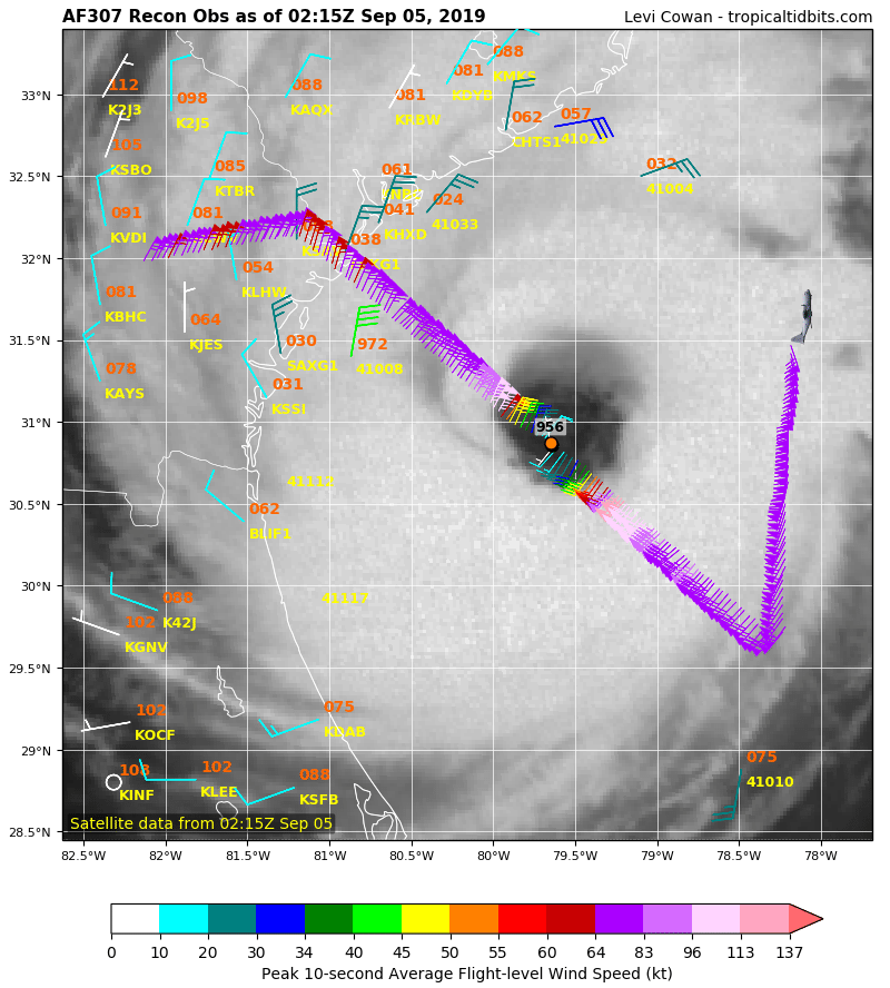
Re: Huracán Dorian.
11:00 PM EDT Wed Sep 4
Location: 31.3°N 79.6°W
Moving: N at 7 mph
Min pressure: 955 mb
Max sustained: 115 mph
Location: 31.3°N 79.6°W
Moving: N at 7 mph
Min pressure: 955 mb
Max sustained: 115 mph
-
cicloncuba
- Invest

- Posts: 183
- Joined: Thu May 02, 2019 2:50 pm
Re: Huracán Dorian.
CON LA NATURALEZA NO HAY MODELOS NI PREDICCIONES Q VALGAN.