Aquí encontrarás todo lo relacionado al la meteorología en Puerto Rico y las condiciones del tiempo actuales, así como los huracanes que se desarrollen durante las temporadas ciclónicas, actualizados por expertos y aficionados a la meteorología de todo el pais! Este es tu foro! Leelo, escribe en el y disfrútalo! Cycloman.
Tardo 24 horas en ser oficial, pero me alegra ver que se hizo a tiempo pues me preocupaba Barbados.
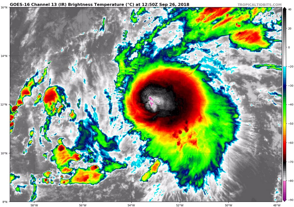
Esta temporada la palabra incertidumbre ha sido parte de la mayoria de los TWO. Una temporada algo extrana. No obstante, me gusta cuando en los TWO explican el motivo para llegar a conclusiones. La insistencia con el "shear" me llevo a ir a la imagen de vapor y tratar de analizar el "mapita"como en los tiempos de Hugo y ahi se vio una tendencia. No siempre, pero en algunas ocasiones es mas importante ver las variables de los modelos que el "output". Cuando vi esa tendencia del TUTT mire aqui y en otros foros, pero nadie comentaba de este sistema. Estaba como el personaje de Anita la Huerfanita. . El tema era el Invest 98, por eso solo deje la pregunta pues no me atrevi a ir contra la corriente pues tampoco yo estaba tan seguro.
Interesante que sea tormenta con 45 millas, pues el "shear" la esta afectado. Antes de ser tormenta oficial, habia menos "shear" y los vientos estoy casi seguro que eran mayores, pues estaba muy robusta. Ellos siguen estimando un "shear" de cerca de 30 o 40 nudos cuando pase el arco de las Antillas. Eso es tambien un estimado. Cualquier cambio en ese pronostico, seria cuando el sistema esta cerca de la 62 de longitud. Por tanto, hay que seguir mirando que pasa aun cuando el "shear" vuelva a tratar de destruir este sistema.
"Georgy Girl", The Seekers
"Back for Good", Take That "Perfectionist", SAGA
"Graves Into Gardens", Elevation Worship ft. Brandon Lake
"Thunder", Imagine Dragons
"Viva la Vida", Coldplay
El regreso de Kirk, lo que se veía en los satélites fue confirmado, veremos como puede evolucionar y si en fin esos vientos cortantes están tan fuertes, personalmente no los veo tan prohibitivo. Los valores en los mapas fuerte el shear, pero en el loop de las imágenes del satélite no parecen que estén tan altos. Veremos
Dos vuelos programados del caza huracanes para hoy.
I. ATLANTIC REQUIREMENTS
1. REMNANTS OF TROPICAL DEPRESSION KIRK
FLIGHT ONE -- TEAL 74 FLIGHT TWO -- TEAL 75
A. 26/1500Z A. 26/2330Z,27/0530Z
B. AFXXX 0112A INVEST B. AFXXX 0212A KIRK
C. 26/1230Z C. 26/2130Z
D. 11.8N 53.5W D. 12.5N 56.0W
E. 26/1430Z TO 26/1900Z E. 26/2300Z TO 27/0530Z
F. SFC TO 10,000 FT F. SFC TO 10,000 FT
ULLETIN
Tropical Storm Kirk Intermediate Advisory Number 10A
NWS National Hurricane Center Miami FL AL122018
800 AM AST Wed Sep 26 2018
...KIRK HEADED FOR THE NORTHERN WINDWARD ISLANDS...
SUMMARY OF 800 AM AST...1200 UTC...INFORMATION
----------------------------------------------
LOCATION...12.0N 53.5W
ABOUT 415 MI...665 KM E OF BARBADOS
ABOUT 535 MI...865 KM ESE OF MARTINIQUE
MAXIMUM SUSTAINED WINDS...45 MPH...75 KM/H
PRESENT MOVEMENT...W OR 280 DEGREES AT 18 MPH...30 KM/H
MINIMUM CENTRAL PRESSURE...1004 MB...29.65 INCHES
WATCHES AND WARNINGS
--------------------
CHANGES WITH THIS ADVISORY:
The government of Barbados has issued a Tropical Storm Warning for
Dominica. The government of France has issued a Tropical Storm
Warning for Guadeloupe and Martinique.
SUMMARY OF WATCHES AND WARNINGS IN EFFECT:
A Tropical Storm Warning is in effect for...
* Barbados
* St. Lucia
* Dominica
* Martinique
* Guadeloupe
A Tropical Storm Watch is in effect for...
* St. Vincent and the Grenadines
A Tropical Storm Warning means that tropical storm conditions are
expected somewhere within the warning area within 36 hours.
A Tropical Storm Watch means that tropical storm conditions are
possible within the watch area, in this case within 36 hours.
Interests elsewhere in the central and northern Lesser Antilles
should monitor the progress of Kirk as additional warnings or
watches could be issued later today.
For storm information specific to your area, please monitor
products issued by your national meteorological service.
DISCUSSION AND OUTLOOK
----------------------
At 800 AM AST (1200 UTC), the center of Tropical Storm Kirk was
located near latitude 12.0 North, longitude 53.5 West. Kirk is
moving toward the west near 18 mph (30 km/h). A westward to
west-northwestward motion is expected through Friday night. On the
forecast track, Kirk is expected to approach Barbados and the
northern Windward Islands Thursday afternoon and move into the
eastern Caribbean Sea by Friday morning.
Maximum sustained winds are near 45 mph (75 km/h) with higher
gusts. Little change in strength is forecast until Kirk moves
through the central Lesser Antilles Thursday afternoon and evening.
Rapid weakening is expected on Friday after Kirk moves over the
eastern Caribbean Sea.
Tropical-storm-force winds extend outward up to 115 miles (185 km)
from the center.
The estimated minimum central pressure is 1004 mb (29.65 inches).
HAZARDS AFFECTING LAND
----------------------
WIND: Tropical storm conditions are expected to first reach the
warning area by Thursday afternoon, making outside preparations
difficult or dangerous. Tropical storm conditions are possible
within the watch area by Thursday afternoon or evening.
RAINFALL: Kirk is expected to produce total rainfall totals of
4 to 6 inches with maximum totals of 10 across the northern Windward
and southern Leeward Islands from Barbados and St. Lucia northward
across Martinique, Dominica, and Guadeloupe. These rains may
produce life-threatening flash floods and mudslides.
NEXT ADVISORY
-------------
Next complete advisory at 1100 AM AST.
$$
Forecaster Pasch
emh- huracan es simplemente ahora Edgardo. Importante: Phil Klotzbach, recordó que "el mejor momento para prepararse para los huracanes es cuando todavía no hay huracanes".
Hurricane’s hit Puerto Rico: San Felipe 1928, San Ciprián 1932, Santa Clara 1956, Hugo 1989, Marilyn 1995, Hortense 1996, Georges 1998, Maria 2017, Fiona 2022
BULLETIN
Tropical Storm Kirk Advisory Number 11
NWS National Hurricane Center Miami FL AL122018
1100 AM AST Wed Sep 26 2018
...KIRK A LITTLE STRONGER...
SUMMARY OF 1100 AM AST...1500 UTC...INFORMATION
-----------------------------------------------
LOCATION...12.1N 54.3W
ABOUT 360 MI...575 KM ESE OF BARBADOS
ABOUT 485 MI...780 KM ESE OF MARTINIQUE
MAXIMUM SUSTAINED WINDS...50 MPH...85 KM/H
PRESENT MOVEMENT...W OR 280 DEGREES AT 18 MPH...30 KM/H
MINIMUM CENTRAL PRESSURE...1002 MB...29.59 INCHES
WATCHES AND WARNINGS
--------------------
CHANGES WITH THIS ADVISORY:
None.
SUMMARY OF WATCHES AND WARNINGS IN EFFECT:
A Tropical Storm Warning is in effect for...
* Barbados
* St. Lucia
* Dominica
* Martinique
* Guadeloupe
A Tropical Storm Watch is in effect for...
* St. Vincent and the Grenadines
A Tropical Storm Warning means that tropical storm conditions are
expected somewhere within the warning area within 36 hours.
A Tropical Storm Watch means that tropical storm conditions are
possible within the watch area, in this case within 36 hours.
Interests elsewhere in the central and northern Lesser Antilles
should monitor the progress of Kirk as additional warnings or
watches could be issued later today.
For storm information specific to your area, please monitor
products issued by your national meteorological service.
DISCUSSION AND OUTLOOK
----------------------
At 1100 AM AST (1500 UTC), the center of Tropical Storm Kirk was
located near latitude 12.1 North, longitude 54.3 West. Kirk is
moving toward the west near 18 mph (30 km/h). A westward to
west-northwestward motion is expected over the next few days.
On the forecast track, the center will move over the Lesser Antilles
within the Tropical Storm Warning area Thursday night.
Maximum sustained winds have increased to near 50 mph (85 km/h)
with higher gusts. Little change in strength is forecast until
Kirk crosses the Lesser Antilles, followed by weakening over the
eastern Caribbean Sea.
Tropical-storm-force winds extend outward up to 115 miles (185 km)
from the center.
The minimum central pressure estimated from Air Force Hurricane
Hunter observations is 1002 mb (29.59 inches).
HAZARDS AFFECTING LAND
----------------------
WIND: Tropical storm conditions are expected to first reach the
warning area by Thursday afternoon, making outside preparations
difficult or dangerous. Tropical storm conditions are possible
within the watch area by Thursday afternoon or evening.
RAINFALL: Kirk is expected to produce total rainfall of 4 to 6
inches across the northern Windward and southern Leeward Islands
with isolated maximum totals up to 10 inches across Martinique and
Dominica. These rains may produce life-threatening flash floods and
mudslides.
NEXT ADVISORY
-------------
Next intermediate advisory at 200 PM AST.
Next complete advisory at 500 PM AST.
$$
Forecaster Pasch
emh- huracan es simplemente ahora Edgardo. Importante: Phil Klotzbach, recordó que "el mejor momento para prepararse para los huracanes es cuando todavía no hay huracanes".