
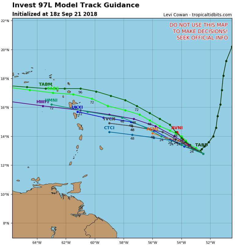
Depresión tropical #11 (Invest 97L)

Re: Disturbio en el Atlántico central 10%-20%
A las 2 pm bajó a 10%-10%... su ventana se cierra.
Siempre la Madre Naturaleza es la última que ríe.


Re: Invest 97L al Este de las Antillas 10%-10%
Tropical Weather Outlook
NWS National Hurricane Center Miami FL
Issued by the NWS Weather Prediction Center College Park MD
800 AM EDT Fri Sep 21 2018
For the North Atlantic...Caribbean Sea and the Gulf of Mexico:
Showers and thunderstorms associated with a tropical wave located
about 600 miles southeast of the Cabo Verde Islands are showing some
signs of organization. The environment is forecast to be conducive
for slow development, and a tropical depression could form early
next week while the system moves westward at 15 to 20 mph across the
low latitudes of the eastern and central tropical Atlantic Ocean.
* Formation chance through 48 hours...low...20 percent.
* Formation chance through 5 days...medium...60 percent.
A weak low pressure area located about 600 miles east of the
Windward Islands is producing disorganized showers and
thunderstorms. The combination of dry mid-level air and strong
upper-level winds is expected to hinder any further development of
this low while it moves west-northwestward at around 10 mph.
* Formation chance through 48 hours...low...10 percent.
* Formation chance through 5 days...low...10 percent.
A broad area of low pressure located just southeast of Bermuda is
producing minimal shower activity while it moves southward at 10 to
15 mph. Although a combination of dry air and strong upper-level
winds is expected to inhibit any significant development over the
next few days, the environment could become conducive for slow
development when the system moves over the southwest Atlantic Ocean
during the middle part of next week.
* Formation chance through 48 hours...low...near 0 percent.
* Formation chance through 5 days...low...20 percent.
A non-tropical low pressure system is forecast to develop tonight
over the central subtropical Atlantic Ocean midway between Bermuda
and the Azores. Conditions are expected to be conducive for the low
to acquire subtropical or tropical characteristics, and a
subtropical or tropical cyclone is expected to form late this
weekend or early next week while the low meanders over the central
Atlantic Ocean.
* Formation chance through 48 hours...low...10 percent.
* Formation chance through 5 days...high...70 percent.
$$
Forecaster Campbell/Blake
emh- huracan es simplemente ahora Edgardo. Importante: Phil Klotzbach, recordó que "el mejor momento para prepararse para los huracanes es cuando todavía no hay huracanes".

Re: Invest 97L al Este de las Antillas 10%-10%
Es correcta esta imagen? Dice que es de hoy, pero un ojo?

-
StormWatch
- Cat. 3

- Posts: 3721
- Joined: Thu Aug 06, 2015 11:39 am
- Location: Texas, USA
Re: Invest 97L al Este de las Antillas 10%-10%
Wepaaaaa!
Vía CycloforumPR
CNH emite boletín especial para la baja presión que está al Este de las Antillas menores y aumenta a 40% la probabilidad de desarrollo ciclónico. Podría convertirse en depresión tropical esta noche o mañana.
Vía CycloforumPR
CNH emite boletín especial para la baja presión que está al Este de las Antillas menores y aumenta a 40% la probabilidad de desarrollo ciclónico. Podría convertirse en depresión tropical esta noche o mañana.
Member Since 2005
For official information, please refer to NHC: https://www.nhc.noaa.gov
Hurricane’s hit Puerto Rico:
San Felipe 1928, San Ciprián 1932, Santa Clara 1956, Hugo 1989, Marilyn 1995, Hortense 1996, Georges 1998, Maria 2017, Fiona 2022
Model Runs:
GFS:
[5:30 AM/PM, 11:30 AM/PM]
HWRF, GFDL, UKMET, NAVGEM:
[6:30-8:00 AM/PM, 12:30-2:00 AM/PM]
ECMWF:
[1:45 AM/PM]
-
StormWatch
- Cat. 3
- Posts: 3721
- Joined: Thu Aug 06, 2015 11:39 am
- Location: Texas, USA
Re: Invest 97L al Este de las Antillas 10%-10%
Ojo! Be AWARE!
Member Since 2005
For official information, please refer to NHC: https://www.nhc.noaa.gov
Hurricane’s hit Puerto Rico:
San Felipe 1928, San Ciprián 1932, Santa Clara 1956, Hugo 1989, Marilyn 1995, Hortense 1996, Georges 1998, Maria 2017, Fiona 2022
Model Runs:
GFS:
[5:30 AM/PM, 11:30 AM/PM]
HWRF, GFDL, UKMET, NAVGEM:
[6:30-8:00 AM/PM, 12:30-2:00 AM/PM]
ECMWF:
[1:45 AM/PM]
For official information, please refer to NHC: https://www.nhc.noaa.gov
Hurricane’s hit Puerto Rico:
San Felipe 1928, San Ciprián 1932, Santa Clara 1956, Hugo 1989, Marilyn 1995, Hortense 1996, Georges 1998, Maria 2017, Fiona 2022
Model Runs:
GFS:
[5:30 AM/PM, 11:30 AM/PM]
HWRF, GFDL, UKMET, NAVGEM:
[6:30-8:00 AM/PM, 12:30-2:00 AM/PM]
ECMWF:
[1:45 AM/PM]
-
StormWatch
- Cat. 3
- Posts: 3721
- Joined: Thu Aug 06, 2015 11:39 am
- Location: Texas, USA
Re: Invest 97L al Este de las Antillas 10%-10%
NHC has issued a special Tropical Weather Outlook to update the chance of formation for the system located 500 mi east of the Windward Islands. A tropical depression could form later today or on Saturday. The updated outlook is available here: nhc.noaa.gov/gtwo.php?basin…
Member Since 2005
For official information, please refer to NHC: https://www.nhc.noaa.gov
Hurricane’s hit Puerto Rico:
San Felipe 1928, San Ciprián 1932, Santa Clara 1956, Hugo 1989, Marilyn 1995, Hortense 1996, Georges 1998, Maria 2017, Fiona 2022
Model Runs:
GFS:
[5:30 AM/PM, 11:30 AM/PM]
HWRF, GFDL, UKMET, NAVGEM:
[6:30-8:00 AM/PM, 12:30-2:00 AM/PM]
ECMWF:
[1:45 AM/PM]
For official information, please refer to NHC: https://www.nhc.noaa.gov
Hurricane’s hit Puerto Rico:
San Felipe 1928, San Ciprián 1932, Santa Clara 1956, Hugo 1989, Marilyn 1995, Hortense 1996, Georges 1998, Maria 2017, Fiona 2022
Model Runs:
GFS:
[5:30 AM/PM, 11:30 AM/PM]
HWRF, GFDL, UKMET, NAVGEM:
[6:30-8:00 AM/PM, 12:30-2:00 AM/PM]
ECMWF:
[1:45 AM/PM]
Re: Invest 97L al Este de las Antillas 10%-10%
Este es un ciclón en toda regla, con ojo y todo...aunque medio snú en el satélite.
Estos sistemas que surgen casi de la nada, una vez cogen cpnfianza son duros de pelar.
Tenemos suerte que los vientos no lo van a soltar al menos por los proximos tres dias...como contrapeso, los niveles de humedad mejoran, según las imagenes de vapor y comienza a entrar en aguas mas calientes.
Crucen los dedos para que el shear no baje, pero ni un tantito y esto no le de por arroparse entrando al Caribe...pudiera convertirse en tormenta en menos de lo que se pela un guineo.
Y...ni modo, nada por encima de una platanera es bienvenido en estos tiempos.
-
huracan sur
- Depresión Tropical

- Posts: 400
- Joined: Wed Sep 04, 2013 3:26 am
Re: Invest 97L al Este de las Antillas 10%-10%
Opino igual que David, yo nunca le quité el ojo a este sistema. Su circulación fue muy persistente incluso batallando contra el shear. Estos casos se dan a veces sin apoyo alguno de los modelos. Pero para mí esto es ciclon desde esta madrugada, claro opinión muy personal
Para información oficial favor referirse a las agencias pertinentes. Un aficionado a la meteorología #TeamCycloforums
-
StormWatch
- Cat. 3
- Posts: 3721
- Joined: Thu Aug 06, 2015 11:39 am
- Location: Texas, USA
Re: Invest 97L al Este de las Antillas 10%-10%
En el visible se ve q tiene un amplio movimiento.

Member Since 2005
For official information, please refer to NHC: https://www.nhc.noaa.gov
Hurricane’s hit Puerto Rico:
San Felipe 1928, San Ciprián 1932, Santa Clara 1956, Hugo 1989, Marilyn 1995, Hortense 1996, Georges 1998, Maria 2017, Fiona 2022
Model Runs:
GFS:
[5:30 AM/PM, 11:30 AM/PM]
HWRF, GFDL, UKMET, NAVGEM:
[6:30-8:00 AM/PM, 12:30-2:00 AM/PM]
ECMWF:
[1:45 AM/PM]
For official information, please refer to NHC: https://www.nhc.noaa.gov
Hurricane’s hit Puerto Rico:
San Felipe 1928, San Ciprián 1932, Santa Clara 1956, Hugo 1989, Marilyn 1995, Hortense 1996, Georges 1998, Maria 2017, Fiona 2022
Model Runs:
GFS:
[5:30 AM/PM, 11:30 AM/PM]
HWRF, GFDL, UKMET, NAVGEM:
[6:30-8:00 AM/PM, 12:30-2:00 AM/PM]
ECMWF:
[1:45 AM/PM]