
Tormenta Isaac
Re: Tormenta Isaac
Buenos dias; ya llego el cazahuranes a Isaac esperemos a ver que en escuentra. Aunque no se ve bien esperemos. No se vayannn regresen aun no a pasado por el sur..
-
La Gatha 7
- Onda Tropical

- Posts: 5
- Joined: Sat Sep 08, 2018 10:20 pm

Re: Tormenta Isaac
BULLETIN
Tropical Storm Isaac Advisory Number 20
NWS National Hurricane Center Miami FL AL092018
1100 AM AST Wed Sep 12 2018
...ISAAC SHOULD REACH THE LESSER ANTILLES EARLY THURSDAY...
SUMMARY OF 1100 AM AST...1500 UTC...INFORMATION
-----------------------------------------------
LOCATION...15.0N 54.7W
ABOUT 420 MI...675 KM E OF MARTINIQUE
ABOUT 455 MI...730 KM E OF GUADELOUPE
MAXIMUM SUSTAINED WINDS...60 MPH...95 KM/H
PRESENT MOVEMENT...W OR 275 DEGREES AT 17 MPH...28 KM/H
MINIMUM CENTRAL PRESSURE...1000 MB...29.53 INCHES
WATCHES AND WARNINGS
--------------------
CHANGES WITH THIS ADVISORY:
None.
SUMMARY OF WATCHES AND WARNINGS IN EFFECT:
A Tropical Storm Warning is in effect for...
* Martinique
* Dominica
* Guadeloupe
A Tropical Storm Watch is in effect for...
* Antigua
* Montserrat
* St. Kitts and Nevis
* Saba and St. Eustatius
A Tropical Storm Warning means that tropical storm conditions are
expected somewhere within the warning area within 24 to 36 hours.
A Tropical Storm Watch means that tropical storm conditions are
possible within the watch area, in this case within 24 to 36 hours.
Interests elsewhere in the Leeward Islands should monitor the
progress of Isaac.
For storm information specific to your area, please monitor products
issued by your national meteorological service.
DISCUSSION AND OUTLOOK
----------------------
At 1100 AM AST (1500 UTC), the center of Tropical Storm Isaac was
located by a NOAA Hurricane Hunter aircraft near latitude 15.0
North, longitude 54.7 West. Isaac is moving toward the west near 17
mph (28 km/h), and this general motion with some decrease in forward
is expected to continue through the weekend. On the forecast track,
Isaac is forecast to move across the central Lesser Antilles and
into the eastern Caribbean Sea on Thursday, and then move across the
eastern and central Caribbean Sea through Saturday.
Aircraft data indicate that maximum sustained winds remain near 60
mph (95 km/h) with higher gusts. Gradual weakening is forecast
during the next 72 hours.
Tropical-storm-force winds extend outward up to 175 miles (280 km),
primarily to the north of the center.
The estimated minimum central pressure is 1000 mb (29.53 inches).
HAZARDS AFFECTING LAND
----------------------
RAINFALL: Isaac is expected to produce total rainfall accumulations
of 2 to 4 inches with isolated amounts up 8 inches across
Martinique, Dominica, and Guadeloupe, 1 to 2 inches with isolated
amounts to 4 inches across Puerto Rico and the southern United
States Virgin Islands, with up to an inch anticipated across the
remaining Windward and Leeward Islands. This rainfall may cause
life-threatening flash flooding.
WIND: Tropical storm conditions are expected on Martinique,
Dominica, and Guadeloupe early Thursday. Tropical storm conditions
are possible within the tropical storm watch area on Thursday.
STORM SURGE: Some coastal flooding is possible in areas of onshore
winds. Near the coast, the surge will be accompanied by large
waves.
SURF: Swells generated by Isaac will begin to affect portions
of the Lesser Antilles this afternoon. These swells are likely to
cause life-threatening surf and rip current conditions. Please
consult products from your local weather office.
NEXT ADVISORY
-------------
Next intermediate advisory at 200 PM AST.
Next complete advisory at 500 PM AST.
$$
Forecaster Blake
emh- huracan es simplemente ahora Edgardo. Importante: Phil Klotzbach, recordó que "el mejor momento para prepararse para los huracanes es cuando todavía no hay huracanes".
-
ROCKstormSJ4315

- Tormenta Tropical

- Posts: 888
- Joined: Tue Aug 06, 2013 10:09 pm
- Location: Hato Rey, San Juan, PR
Re: Tormenta Isaac
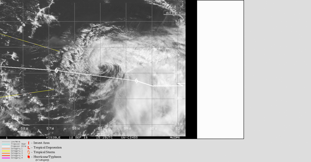
Tal como dije esta madrugada, el sistema sigue batallando aun cuando su centro esta expuesto. Mientras mantenga el centro de circulacion, los efectos indirectos persisten y no pueden dejar pasar por alto esto. Miren la foto de trayectoria junto con el alcance de los vientos. 50 millas mas o menos que suba el area sur podria estar expuesta a los vientos de fuerza de tormenta tropical. La infraestructura no esta bien por lo que ni aun los efectos indirectos de Isaac, si mantiene su identidad, nos conviene. Esta vez es data real pues el caza anda en las cercanias de Isaac. Aqui la ultima informacion, marcando en rojo lo mas importante y en azul mis comentarios:
NHC TD 11 AM:
"Tropical Storm Isaac Discussion Number 20
NWS National Hurricane Center Miami FL AL092018
1100 AM AST Wed Sep 12 2018
GOES-16 1-minute satellite imagery along with NOAA Hurricane Hunter
data show that the center of Isaac has become fully exposed on the
northwestern side of a shrinking area of deep convection. There is
still a lot of wind there, however, with the NOAA plane observing
SFMR and adjusted flight-level winds to support 50 kt as an initial
intensity.
An upper-level trough is dropping southward over the central
Atlantic, which has increased the shear this morning over Isaac.
This high shear is forecast to remain for the next day or two, and
it is possible that Isaac will degrade into a tropical wave during
that time, although the area of tropical-storm-force winds will
likely not go away for a while. In a couple of days, while the
wind shear could decrease over the east-central Caribbean Sea, there
might not be much of a system left to take advantage of the more
conducive conditions. Por primera vez se habla de una disminucion del :shear". No obstante el estimado es que ocurra en dos dias, cuando esta pasando por el sur de PR, y proyectando que ya estaria muy debil para aprovecharse de eso. Y si persiste y no degenera en una onda para ese tiempo? As a compromise, the official forecast
shows a slow weakening, in the direction of the model consensus,
and continues to show dissipation after 96 hours in line with the
GFS/ECMWF guidance. I wouldn't pay much attention to the long
range forecast for now, given the uncertainties in Isaac surviving
during the next day or two.
The low-level center of Isaac has recently accelerated, moving
westward at 15 kt, as it decoupled from the slower mid-level flow.Esto ya se estaba viendo desde ayer.
Assuming the system stays vertically coherent, a large
mid-tropospheric high is forecast to persist for the next several
days. This should keep the system moving westward at a somewhat
slower pace throughout the forecast period. There isn't much spread
in the guidance, and the official forecast is close to the previous
one after accounting for the initial position. The long-range track
forecast highly depends on the intensity forecast, so it should be
considered low confidence.
Key Messages:
1. Isaac is expected to remain at tropical storm intensity when it
moves across the Lesser Antilles on Thursday, and tropical storm
warnings are in effect for Martinique, Dominica, and Guadeloupe.
Tropical storm watches are in effect for Montserrat, St. Kitts and
Nevis, Antigua, and Saba and St. Eustatius. Interests on those
islands should follow any advice given by their local officials.
2. Life-threatening flash flooding is possible with Isaac. The
storm is expected to produce total rainfall accumulations of 2 to 4
inches with isolated amounts up 8 inches across Martinique,
Dominica and Guadeloupe. Rainfall amounts of 1 to 2 inches with
isolated amounts to 4 inches are expected across Puerto Rico and the
southern United States Virgin Islands.
FORECAST POSITIONS AND MAX WINDS
INIT 12/1500Z 15.0N 54.7W 50 KT 60 MPH
12H 13/0000Z 15.1N 56.7W 50 KT 60 MPH
24H 13/1200Z 15.3N 59.4W 45 KT 50 MPH
36H 14/0000Z 15.3N 62.6W 45 KT 50 MPH
48H 14/1200Z 15.4N 65.6W 40 KT 45 MPH
72H 15/1200Z 15.5N 71.0W 40 KT 45 MPH
96H 16/1200Z 15.5N 75.0W 35 KT 40 MPH
120H 17/1200Z...DISSIPATED
$$
Forecaster Blake"
Un poco mas que suba y estaria interesante. Yo llevo dias hablando de la latitud 16.5, llegara ahi? Eso esta por verse. No obstante ya hay un aviso de tormenta tropical para las aguas al sur de PR. Ojo, digo las aguas al sur de PR, no la isla.
NWS en Carolina:
Caribbean Sea
NWS National Hurricane Center Miami, FL
1105 AM EDT Wed Sep 12 2018
Offshore Waters Forecast for the Tropical N Atlantic from 07N to
22N between 55W and 64W, the SW N Atlantic S of 31N W of 65W
including Bahamas, and the Caribbean Sea.
Seas given as significant wave height, which is the average
height of the highest 1/3 of the waves. Individual waves may be
more than twice the significant wave height.
"Caribbean N of 15N between 64W and 72W-
1105 AM EDT Wed Sep 12 2018
...TROPICAL STORM WARNING... Ojo y recalco, aguas al sur de PR, no para la isla
.TODAY...NE to E winds 10 to 15 kt. Seas 2 to 4 ft.
.TONIGHT...NE to E winds 10 to 15 kt. Seas 2 to 4 ft.
.THU...NE winds 15 to 20 kt. Seas 4 to 6 ft.
.THU NIGHT... TROPICAL STORM CONDITIONS EXPECTED. NE winds 20 to
25 kt, becoming N to NE 35 to 40 kt late. Seas 6 to
9 ft. Scattered showers.
.FRI... TROPICAL STORM CONDITIONS POSSIBLE. NE winds 35 to 40 kt.
Seas 7 to 11 ft.
.FRI NIGHT... TROPICAL STORM CONDITIONS POSSIBLE.
.SAT... TROPICAL STORM CONDITIONS POSSIBLE.
.SAT NIGHT... TROPICAL STORM CONDITIONS POSSIBLE.
.SUN...SE winds 15 to 20 kt. Seas 3 to 5 ft."
NWS Carolina
Area Forecast Discussion...UPDATED
National Weather Service San Juan PR
1220 PM AST Wed Sep 12 2018
.UPDATE...The morning sounding from San Juan came in quite dry
with only 1.29 inches of precipitable water. This corresponds
quite well with the dry slot moving over the area that is
indicated in the MIMIC Total Precipitable Water product. The
trailing edge of the dry slot has moved over the northern U.S.
Virgin Islands and was heralded by brief heavy showers that
reduced visibilities to less than 2 miles. The rain band is part
of a wide feeder band spiraling into Isaac from the north and will
continue over the area through around noon Thursday.
Showers are expected to gradually increase while remaining widely
spaced and scattered. An area of dust forming a hemisphere over
the north part of Tropical Cyclone Isaac will also play a role in
reducing the showers not in the immediate vicinity of the storm.
Winds are expected to increase Thursday morning and will be
generally northeast at 15 to 25 mph in exposed areas, as long as
the track of Tropical Storm Isaac continues as forecast and will
likely increase with higher gusts on Friday. There is some
possibility that Isaac will degenerate into a strong tropical
wave before it passes south of our local waters, but these winds
are still likely.
&&
.AVIATION...Although TIST became MVFR for a brief period with
heavy rain and TNCM also became MVFR due to CIGs, VFR is expected
to continue at all stations thru 12/18Z as a band of dry air moves
through the area. SHRA to increase aft 12/22Z with some MVFR conds
and mtn obscurations. Sfc winds ENE 5 to 18 kt with sea breeze
influences. Winds will increase above 20 kt in exposed locations
aft 14/15Z. Max winds FL017-150 ENE 20-25 kt bcmg E 20-35 kt aft
14/09Z.
&&
.MARINE...Seas are expected to increase first in the northeast
local outer Atlantic waters tonight with up to 9 feet by the end
of the night. Maximum seas are expected to move west across the
southern outer Caribbean waters Thursday night and Friday and seas
my reach at least 12 feet during the passage of Tropical Storm
Isaac south of the area during that time.
&&
.HYDROLOGY...The passage of Tropical Storm Isaac will generate
rainfall amounts of 1 to 2 inches with local amounts up to 4
inches. The locally higher amounts are expected along the
southeast coast of Puerto Rico. Rainfall in the U.S. Virgin
Islands is expected to be highest in Saint Croix where around 2
inches are expected. Rain in Saint Thomas and Saint John will be
only somewhat less.
".PREV DISCUSSION... /issued 532 AM AST Wed Sep 12 2018/
SYNOPSIS...The proximity of a Tutt low just west of the region
and a plume of moisture in the prevailing east to northeast flow
ahead of Tropical Storm Isaac will support showers and isolated
thunderstorm activity across the coastal waters and parts of the
islands the rest of today. Based on the current forecast track,
Tropical Cyclone Isaac is forecast to move westward and remain
south of Puerto Rico and the U.S. Virgin Islands late Thursday
evening through Friday. A moist and unstable environment will
persist for the next several day and into the upcoming weekend.
SHORT TERM...Today through Friday...
The entrance of an elongated area of a somewhat drier air ahead of
Tropical Storm Isaac will reach the forecast area early this morning
and will cross the local islands throughout the day. Although this
feature will bring mostly tranquil weather conditions across the
region, streamer-like showers moving over the waters into eastern
Puerto Rico and the U.S. Virgin Islands during the morning hours, as
well as afternoon showers and thunderstorms developing over the
interior and western Puerto Rico remains possible due to the diurnal
effects. Urban and small stream flooding is likely across these areas.
Once this area of drier air continues to move westward and away from
the local islands, weather conditions are expected to deteriorate as
Isaac`s forward outer band streams across the region late Wednesday
night into Thursday. This will feed squally weather conditions along
with gusty winds and frequent lightning activity across the forecast
area as it progress westward. Streamer-like showers and thunderstorms
will move over the waters into land areas early Thursday morning into
Thursday afternoon, then afternoon convection will be triggered over
portions of the interior and western Puerto Rico. A secondary event
is then expected on Friday as Isaac approaches the local area. Although
the storm is expected to remain south of the local islands, showers
and thunderstorms are expected across most of the forecast area. Based
on the current forecast, total rainfall accumulations are forecast
to range between 1 and 3 inches with isolated higher amount`s. Thus,
urban and small stream flooding, rapid rises along rivers, and mudslides
near steep terrain are highly likely during this forecast period.
Ojo con los efectos indirectos.
LONG TERM...Saturday through Wednesday...
Tropical Storm Isaac is still surrounded by uncertainties as far
as intensity, as it is expected to continue to feel the effects of
westerly and northwesterly shear. However the current forecast
shows it passing south of the U.S.Virgin Islands and Puerto Rico
from Friday through Saturday. It will likely bring seas between 8
to 10 feet at least through Saturday mainly over the southern
portion of the local Caribbean waters and passages. After the
passage of Isaac, a moist southeasterly flow will continue across
the region through most of the upcoming weekend and into early
next week. Recent model guidance continued to suggest layered
precipitable water values in excess of 2 inches into early next
week. This along with the proximity of another Tutt low will
maintain a moist and unstable environment through ahd least Monday
of next week with a gradual improvement by Tuesday. That said,
expect fairly wet weather pattern favorable which will support
periods of moderate to heavy rainfall with showers and isolated
thunderstorm activity most of the period. Local urban and small
stream flooding will remain possible each day with potential for
mudslides in areas of steep terrain. However,model guidance still
do not suggest widespread flooding during the period.
AVIATION...VFR conditions will prevail across most terminals through
the forecast period. However, MVFR conditions are expected across
the TNCM terminal this afternoon as occasional bands of passing
showers move across the area in the northeasterly wind flow. SHRA/TSRA
are expected to develop across the interior and western portion of
Puerto Rico on Wednesday afternoon for possible impacts across TJMZ.
Surface winds will be from the northeast across all area sites through
the forecast period light up to 8 knots becoming 10 to 15 knots aft
12/14z with sea breeze variations.
MARINE...Seas up to 6 feet over the Atlantic waters and Caribbean
passages with easterly winds 10 to 20 kts today. Later this evening
and overnight, expect increasing and deteriorating seas up to 8
to 10 feet over the offshore Atlantic and Caribbean waters and
local passages with the approach of Tropical Storm Isaac. Therefore,
a small craft operators are urge to exercise caution today and
small craft advisories will be in effect later this evening.
Please refer to the latest Marine Weather Message (MWWSJU) and
Coastal Waters Forecast (CWFSJU) issued by the National Weather
service WFO San Juan PR."
Ojo con la lluvia pues entre Isaac y el TUTT se espera lluvia fuerte en diversos lugares de la ia en los proximos dias.
"Georgy Girl", The Seekers
"Back for Good", Take That
"Perfectionist", SAGA
"Graves Into Gardens", Elevation Worship ft. Brandon Lake
"Thunder", Imagine Dragons
"Viva la Vida", Coldplay
"Back for Good", Take That
"Perfectionist", SAGA
"Graves Into Gardens", Elevation Worship ft. Brandon Lake
"Thunder", Imagine Dragons
"Viva la Vida", Coldplay

Re: Tormenta Isaac
Eso estaba viendo
-
Laniña2016
- Invest

- Posts: 212
- Joined: Sat May 28, 2016 7:19 am
Re: Tormenta Isaac
Algunos modelos lo traen mas cerca, veremos que sucede
Re: Tormenta Isaac
Mirando en el satélite se ve mucho más arriba de la 15.1. Esto me está poniendo nerviosa.
