

BULLETIN
Tropical Storm Isaac Advisory Number 16
NWS National Hurricane Center Miami FL AL092018
1100 AM AST Tue Sep 11 2018
...HURRICANE AND TROPICAL STORM WATCHES ISSUED FOR ISAAC...
SUMMARY OF 1100 AM AST...1500 UTC...INFORMATION
-----------------------------------------------
LOCATION...14.6N 49.7W
ABOUT 775 MI...1250 KM E OF THE LESSER ANTILLES
MAXIMUM SUSTAINED WINDS...70 MPH...110 KM/H
PRESENT MOVEMENT...W OR 270 DEGREES AT 16 MPH...26 KM/H
MINIMUM CENTRAL PRESSURE...996 MB...29.42 INCHES
WATCHES AND WARNINGS
--------------------
CHANGES WITH THIS ADVISORY:
The government of France has issued a Hurricane Watch for Guadeloupe
and Martinique.
The government of Barbados has issued a Hurricane Watch for
Dominica.
The meteorological service of Antigua and Barbuda has issued a
Tropical Storm Watch for Antigua and Montserrat.
SUMMARY OF WATCHES AND WARNINGS IN EFFECT:
A Hurricane Watch is in effect for...
* Guadeloupe
* Martinique
* Dominica
A Tropical Storm Watch is in effect for...
* Antigua and Montserrat
A Hurricane Watch means that hurricane conditions are possible
within the watch area. A watch is typically issued 48 hours
before the anticipated first occurrence of tropical-storm-force
winds, conditions that make outside preparations difficult or
dangerous.
A Tropical Storm Watch means that tropical storm conditions are
possible within the watch area, generally within 48 hours.
Interests elsewhere in the Leeward Islands should monitor the
progress of Isaac as additional watches could be issued this
afternoon or evening.
For storm information specific to your area, please monitor
products issued by your national meteorological service.
DISCUSSION AND OUTLOOK
----------------------
At 1100 AM AST (1500 UTC), the center of Tropical Storm Isaac was
located near latitude 14.6 North, longitude 49.7 West. Isaac is
moving toward the west near 16 mph (26 km/h) and this motion is
expected to continue for the next few days. On the forecast track
Isaac is anticipated to move near or over the central Lesser
Antilles on Thursday and move into the eastern Caribbean Sea
Thursday night.
Maximum sustained winds remain near 70 mph (110 km/h) with higher
gusts. Isaac is expected to be near hurricane strength when it
moves through the central Lesser Antilles, with some weakening
forecast afterward on Friday.
Tropical-storm-force winds extend outward up to 105 miles (165 km)
from the center.
The estimated minimum central pressure is 996 mb (29.42 inches).
HAZARDS AFFECTING LAND
----------------------
RAINFALL: Isaac is expected to produce total rainfall accumulations
of 3 to 5 inches with isolated amounts near 10 inches across the
southern Leeward Islands late this week, with 1 to 2 inches
anticipated across portions of the Windward Islands.
STORM SURGE: A storm surge of 2 to 4 feet above normal tide levels
is possible near and to the north of where the center moves through
the Lesser Antilles. Near the coast, the surge will be accompanied
by large and destructive waves.
WIND: Hurricane conditions are possible within the hurricane watch
area by Thursday morning, with tropical storm conditions possible
early Thursday in both the hurricane and tropical storm watch areas.
SURF: Swells generated by Isaac will begin to affect portions
of the Lesser Antilles on Wednesday afternoon. These swells are
likely to cause life-threatening surf and rip current conditions.
Please consult products from your local weather office.
NEXT ADVISORY
-------------
Next intermediate advisory at 200 PM AST.
Next complete advisory at 500 PM AST.
$$
Forecaster Blake
Tormenta Isaac
Re: Huracán Isaac
emh- huracan es simplemente ahora Edgardo. Importante: Phil Klotzbach, recordó que "el mejor momento para prepararse para los huracanes es cuando todavía no hay huracanes".
-
StormWatch
- Cat. 3

- Posts: 3721
- Joined: Thu Aug 06, 2015 11:39 am
- Location: Texas, USA
Re: Huracán Isaac
Isaac pasará al Sur de PR.

Member Since 2005
For official information, please refer to NHC: https://www.nhc.noaa.gov
Hurricane’s hit Puerto Rico:
San Felipe 1928, San Ciprián 1932, Santa Clara 1956, Hugo 1989, Marilyn 1995, Hortense 1996, Georges 1998, Maria 2017, Fiona 2022
Model Runs:
GFS:
[5:30 AM/PM, 11:30 AM/PM]
HWRF, GFDL, UKMET, NAVGEM:
[6:30-8:00 AM/PM, 12:30-2:00 AM/PM]
ECMWF:
[1:45 AM/PM]
-
StormWatch
- Cat. 3
- Posts: 3721
- Joined: Thu Aug 06, 2015 11:39 am
- Location: Texas, USA
Re: Huracán Isaac
Vía Twitter CycloforumPR
Basado en el boletín de las 11am, la tormenta Isaac pasaría en su punto más cercano a 172 millas de Ponce, este viernes a las 3:45 pm. Siendo un ciclón de estructura pequeña, los efectos indirectos serían de mínimos a moderados, especialmente el oleaje.
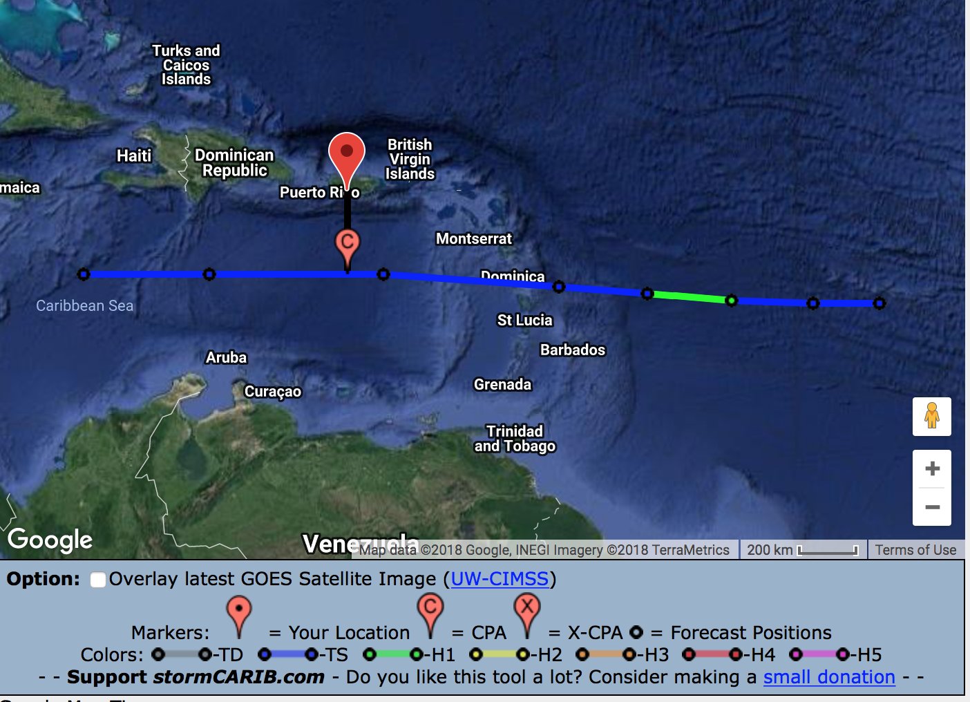
Basado en el boletín de las 11am, la tormenta Isaac pasaría en su punto más cercano a 172 millas de Ponce, este viernes a las 3:45 pm. Siendo un ciclón de estructura pequeña, los efectos indirectos serían de mínimos a moderados, especialmente el oleaje.
Member Since 2005
For official information, please refer to NHC: https://www.nhc.noaa.gov
Hurricane’s hit Puerto Rico:
San Felipe 1928, San Ciprián 1932, Santa Clara 1956, Hugo 1989, Marilyn 1995, Hortense 1996, Georges 1998, Maria 2017, Fiona 2022
Model Runs:
GFS:
[5:30 AM/PM, 11:30 AM/PM]
HWRF, GFDL, UKMET, NAVGEM:
[6:30-8:00 AM/PM, 12:30-2:00 AM/PM]
ECMWF:
[1:45 AM/PM]
For official information, please refer to NHC: https://www.nhc.noaa.gov
Hurricane’s hit Puerto Rico:
San Felipe 1928, San Ciprián 1932, Santa Clara 1956, Hugo 1989, Marilyn 1995, Hortense 1996, Georges 1998, Maria 2017, Fiona 2022
Model Runs:
GFS:
[5:30 AM/PM, 11:30 AM/PM]
HWRF, GFDL, UKMET, NAVGEM:
[6:30-8:00 AM/PM, 12:30-2:00 AM/PM]
ECMWF:
[1:45 AM/PM]
-
StormWatch
- Cat. 3
- Posts: 3721
- Joined: Thu Aug 06, 2015 11:39 am
- Location: Texas, USA
Re: Huracán Isaac
Le están dando DURÍSIMO a Isaac ....

Member Since 2005
For official information, please refer to NHC: https://www.nhc.noaa.gov
Hurricane’s hit Puerto Rico:
San Felipe 1928, San Ciprián 1932, Santa Clara 1956, Hugo 1989, Marilyn 1995, Hortense 1996, Georges 1998, Maria 2017, Fiona 2022
Model Runs:
GFS:
[5:30 AM/PM, 11:30 AM/PM]
HWRF, GFDL, UKMET, NAVGEM:
[6:30-8:00 AM/PM, 12:30-2:00 AM/PM]
ECMWF:
[1:45 AM/PM]
For official information, please refer to NHC: https://www.nhc.noaa.gov
Hurricane’s hit Puerto Rico:
San Felipe 1928, San Ciprián 1932, Santa Clara 1956, Hugo 1989, Marilyn 1995, Hortense 1996, Georges 1998, Maria 2017, Fiona 2022
Model Runs:
GFS:
[5:30 AM/PM, 11:30 AM/PM]
HWRF, GFDL, UKMET, NAVGEM:
[6:30-8:00 AM/PM, 12:30-2:00 AM/PM]
ECMWF:
[1:45 AM/PM]

Re: Huracán Isaac
Se nota la entrada de un buche de SAL
-
StormWatch
- Cat. 3
- Posts: 3721
- Joined: Thu Aug 06, 2015 11:39 am
- Location: Texas, USA
Re: Huracán Isaac
Game OVER!
Yessssssss!

Yessssssss!
Member Since 2005
For official information, please refer to NHC: https://www.nhc.noaa.gov
Hurricane’s hit Puerto Rico:
San Felipe 1928, San Ciprián 1932, Santa Clara 1956, Hugo 1989, Marilyn 1995, Hortense 1996, Georges 1998, Maria 2017, Fiona 2022
Model Runs:
GFS:
[5:30 AM/PM, 11:30 AM/PM]
HWRF, GFDL, UKMET, NAVGEM:
[6:30-8:00 AM/PM, 12:30-2:00 AM/PM]
ECMWF:
[1:45 AM/PM]
For official information, please refer to NHC: https://www.nhc.noaa.gov
Hurricane’s hit Puerto Rico:
San Felipe 1928, San Ciprián 1932, Santa Clara 1956, Hugo 1989, Marilyn 1995, Hortense 1996, Georges 1998, Maria 2017, Fiona 2022
Model Runs:
GFS:
[5:30 AM/PM, 11:30 AM/PM]
HWRF, GFDL, UKMET, NAVGEM:
[6:30-8:00 AM/PM, 12:30-2:00 AM/PM]
ECMWF:
[1:45 AM/PM]
-
ROCKstormSJ4315

- Tormenta Tropical

- Posts: 888
- Joined: Tue Aug 06, 2013 10:09 pm
- Location: Hato Rey, San Juan, PR
Re: Huracán Isaac
El ultimo TWD del NHC creo que tiene muchos cambios en el lenguaje que además de la incertidumbre ya conocida en términos de trayectoria e intensidad. A parte que los verbos, en su mayoría, son condicionales o aquel nombre extraño que para aprendérselo era difícil: pretérito pluscuamperfecto. Mas simple, lo que quiero indicar es que la mayoría de lo que dice esta discusión es condicionada a lo que ocurra con el sistema en las próximas horas con respecto a intensidad y trayectoria. Y me parece que aclaran que eso depende de varios factores que ellos mismos mencionan de los cuales aun no se tiene certeza. Esos factores son fundamentales en las variables que corren los modelos por lo que las corridas salen con un margen de error a considerar.
En rojo está lo que considero importante que encontre de la discusion del NHC en Miami:
Tropical Storm Isaac Discussion Number 16
NWS National Hurricane Center Miami FL AL092018
1100 AM AST Tue Sep 11 2018
One-minute visible satellite data from GOES-16 indicate that
the center of Isaac remains on the westward edge of the central
dense overcast. Parece que sigue afectando el "shear". The initial wind speed is kept at 60 kt, which is a
compromise between the lower subjective estimates and higher ADTs
and microwave estimates. "Estimacion del viento This is a more uncertain estimate than
normal due to the spread of the intensity fixes. The initial wind
and 12 ft seas radii have been expanded out to the north based on
TAFB estimates and microwave data.
The intensity forecast continues to be tricky. Westerly shear
should increase over the next couple of days, which would normally
cause some weakening (causa para frenar intensidad pero,) . However this effect could be tempered by
increasing SSTs, mid-level moisture and instability in the path of
the storm. (estas variables podrian tener efecto en mantener o aumentar intensidad) Given our limited skill in forecasting intensity changes
in marginal environments, plus the 5 or 10 kt of initial wind speed
uncertainty, the official forecast will show no significant change
in intensity for the next couple of days. Because of these
uncertainties, a Hurricane Watch has been issued for many of the
Leeward Islands, even though Isaac is not explicitly forecast to be
a hurricane. (Noten hasta donde al norte extienden los "watch de tormenta tropical") Some weakening is indicated at long range after
considering the global model trends in intensity, which have done
fairly well for Isaac.
The latest initial motion estimate is 270/14. Isaac is forecast to
move westward at about the same speed for the next few days due to
a mid-level ridge over the central Atlantic Ocean. Other than the
UKMET model, there is not much spread in the guidance, except with
the forward speed. Given the strength of the ridge, the cyclone
isn't likely to slow down much, so the official forecast is
basically along the previous forecast track but faster. The
uncertainty increases at long range, and is somewhat dependent on
the intensity of Isaac, but faster seems to be way to go given the
weakening trend anticipated at that time.
Key Messages:
1. Isaac is expected to be at or near hurricane intensity when it
approaches the Lesser Antilles on Thursday, and hurricane and
tropical storm watches have been issued for several islands.
Interests in those areas should follow any advice given by their
local officials.
2. Interests elsewhere in the Lesser Antilles should continue to
monitor Isaac during the next couple of days, as additional watches
could be needed for other islands.
FORECAST POSITIONS AND MAX WINDS
INIT 11/1500Z 14.6N 49.7W 60 KT 70 MPH
12H 12/0000Z 14.6N 51.8W 60 KT 70 MPH
24H 12/1200Z 14.7N 54.4W 65 KT 75 MPH
36H 13/0000Z 14.9N 57.1W 60 KT 70 MPH
48H 13/1200Z 15.1N 59.9W 60 KT 70 MPH
72H 14/1200Z 15.5N 65.5W 55 KT 65 MPH
96H 15/1200Z 15.5N 71.0W 50 KT 60 MPH
120H 16/1200Z 15.5N 75.0W 50 KT 60 MPH
$$
Forecaster Blake"
De nuevo, lo que esta en rojo es lo que a mi entender es importante y a la derecha mi interpretacion.
Miren parte de la discusion del NWS de aqui:
"Area Forecast Discussion
National Weather Service San Juan PR
105 PM AST Tue Sep 11 2018
.UPDATE...
Induced afternoon convection is expected across mainland Puerto
Rico and in the form of streamers downwind from the U.S. Virgin
Islands today. Under a light east to southeast wind flow localized
flooding could be expected through this evening.
Changes were made to the inherited wind field and marine grids in
order to adjust the forecast with the expected weather conditions
associated with Tropical Cyclone Isaac. Based on the latest
forecast track, Isaac is expected to move as a Tropical Storm off
to the south of the local islands between late Thursday into
Friday. However, considerable uncertainties continue with regards
to the track and intensity of Isaac. In addition, Satellite
imagery depict an area ahead of Isaac which could create squally
weather across the region between Wednesday and Thursday
.....PREV DISCUSSION... /issued 712 AM AST Tue Sep 11 2018/
SYNOPSIS...Several minor troughs will move through the area ahead
of Tropical Storm Isaac with afternoon showers and thunderstorms
expected in western and interior Puerto Rico, but only isolated
shower in the U.S. Virgin Islands. Considerable uncertainties
continue with regards to the track and intensity of Isaac, but
present forecasts show it passing south of the forecast area as a
Tropical storm, spreading gusty winds, showers and thunderstorms
across the area. Considerable moisture follows Isaac on Saturday
that will keep the weather wet well into next week..."
Note que aun pasando al sur podriamos tener efectos indirectos y la incertidumbre esta aun. Es por eso que entiendo que aun hay que seguir mirando este sistema por posibles ajustes en trayectoria e intensidad.
Esto es solo mi interpretacion de las discusiones del NHC y la oficina local del NWS en Carolina. Por eso lo que esta en azul en las mismas es mi opinion, lo rojo es lo que entendi importante. No es la interpretacion oficial. Refierase a ambas discusiones para leer las versiones oficiales.
Finalmente, dado la incertidumbre yo prefiero usar verbos condicionales compuestos o condicional simple.
Last edited by ROCKstormSJ4315 on Tue Sep 11, 2018 1:39 pm, edited 1 time in total.
"Georgy Girl", The Seekers
"Back for Good", Take That
"Perfectionist", SAGA
"Graves Into Gardens", Elevation Worship ft. Brandon Lake
"Thunder", Imagine Dragons
"Viva la Vida", Coldplay
"Back for Good", Take That
"Perfectionist", SAGA
"Graves Into Gardens", Elevation Worship ft. Brandon Lake
"Thunder", Imagine Dragons
"Viva la Vida", Coldplay
Re: Huracán Isaac
Alguien me puede decir que diantres ve ese modelo EMC que v dando sigsag y lo sube por cuba. Se imaginan? Algo así sería suficiente p volar en cantos todas las leyes de la naturaleza

Las vaguadas no somos tan malas como algunos creen 
Re: Huracán Isaac
Las vaguadas no somos tan malas como algunos creen